

⚠️ Hiking and scrambling are inherently dangerous activities. Please read my Disclaimer. ⚠️
Poker Peak is another one of those small little winter destinations in the Crowsnest Pass/Castle Crown area. At 1935m it’s not huge, nor is there anything difficult about it. In the summer you could drive up the Adanac Road right to the base of it and be at the top in probably 30 to 45 minutes. It is also one of a number of like-named bumps in the Hillcrest Mountain area (Hearts Peak, Spades Peak, and Clubs Peak). Just down the ridge to the south of Poker Peak is the smaller Maverick Hill, and just beyond that, Carbondale Hill. Immediately to the east lies Byron Hill. If you have the time, you could venture to Maverick Hill and Clubs Peak without much difficulty.
However, with only a limited amount of time to spare on a beautiful, but windy Easter afternoon, Jeff and I contemplated several destinations before we settled on Poker Peak. Since the Adanac (Canada spelled backwards) Road is not maintained in the winter, I 4×4’d up as far as I could before we decided to get out and hike the remaining 4km to the base of the ridge. While a considerable amount of snow has melted, sections of the road were still covered with deep snow. Instead of hiking up to the bottom of the mountain (or hill), I thought it would be good to gain the ridge just north of the summit. While it was windy at times, I’m glad we chose to go this route because the views were stellar. As I’ve said before, I would probably never hike up one of these little bumps in the summer, but for a winter/early spring destination, they are quite fun. Add some snow to the mix, and you are rewarded with some awesome scenery.
EDIT: I returned to Poker Peak in April 2016 as part of a traverse from Maverick Hill. Click to read this trip report.

I 4×4’d as far up the Adanac Road as I could, but that still left us quite far from the summit. We considered ascending the far north end of the ridge, but the snow in this section was still too deep, so we walked along the road for 4km until we came to a bare slope. Here is where we gained the Adanac Ridge just north of Poker Peak. On our way back, we dropped back down a slope just to the south of where we ascended. In a couple of weeks (if not sooner if the weather continues to warm up), the Adanac Road should be drivable again for most vehicles. We were surprised that we did not see one ATV or snowmobile the entire day.
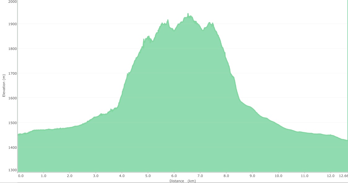
Poker Peak sits at 1935m. We didn’t begin hiking until 2:30pm, so we needed this to be a quick hit and it was, with a round trip time of 4 hours and 4 minutes. Our total distance was 12.7km with a total elevation gain of 620m.

After mashing through some deeper sections of snow on the way up, I turned around and parked on a bare patch of road. This still left us 4km from where we’d begin to hike up the ridge, but it was a fairly easy walk along the road.

A few hundred metres from where we parked, we came across a number of wolf tracks. One wolf in particular had an impressively large paw print.

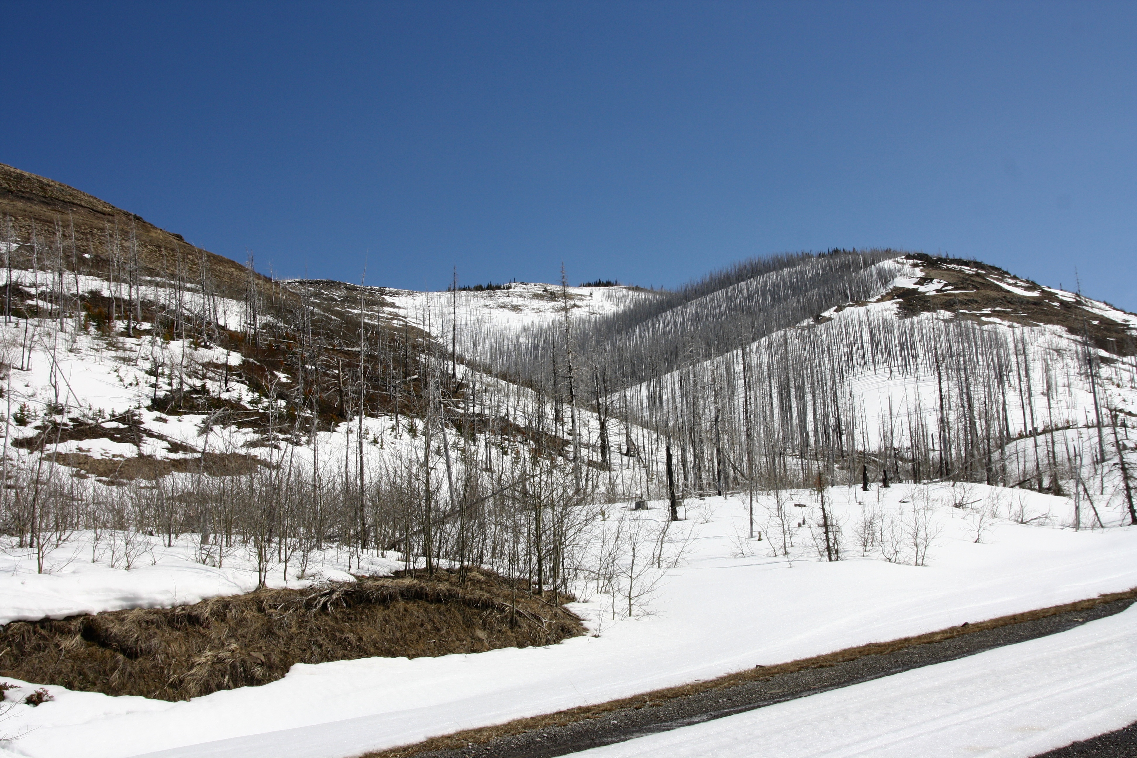
Also not far from our vehicle, we found the first of many kill sites along the road. I’m guessing the wolves and cats in this area ate fairly well over the winter. This picture is looking back down the Adanac Road towards our vehicle (in the distance).

A snow covered Hillcrest Mountain on a beautiful Easter Sunday afternoon.

Jeff snowshoes up the Adanac Road. In the distance is the usual parking spot for hiking up Hillcrest Mountain.
Here is where we left the road to hike up the bare slopes on the left. The route that we used to come down is on the right.

Looking toward the top of Adanac Ridge after gaining some elevation.

It felt good to finally hike on bare ground. (Photo by Jeff Lang)

A beautiful view to the north greeted us once we gained the ridge. From left to right: Willoughby Ridge (distance), Hillcrest Mountain, Turtle Mountain, and the South Peak of the Livingstone Range.

After briefly admiring the above view to the north, we began to hike southward along the ridge.

Buffeted by the wind, Jeff makes his way south along Adanac Ridge. Hillcrest Mountain looks like it’s ready for some visitors.

Our time of hiking on bare ground was about to end.

After not having snowshoes on Mount Backus, Jeff takes full advantage of them on Poker Peak.

Jeff navigates through a cool section of burned out trees.

The summit of Poker Peak comes into view.

There were some decidely deep drifts beneath the summit. You can also see some fresh cat tracks leading to the summit. I guess we weren’t the only ones intent on getting to the top of Poker Peak.

Another shot of Jeff snowshoeing along the ridge. As on Hillcrest Mountain, the burned timber from the 2003 Lost Creek Fire provides an intriguing backdrop for photos.

The final section before the top.

Looking east towards the front range of the Castle Crown.

Jeff took this cool shot of me as I snowshoed to the top. (Photo by Jeff Lang)

The summit of Poker Peak.

Looking east at the front range of the Castle Crown. Left to right: Mount Albert, Mount Backus, Prairie Bluff Mountain, Pincher Ridge, Victoria Peak, Table Mountain, and Whistler Mountain.

Looking to the southeast from the summit. Just to the right of centre is Southfork Mountain, then Gravenstafel Ridge, Mount Haig, and Syncline Mountain.

Another view to the south showing Southfork Mountain and Syncline Mountain.

A view further to the south along Adanac Ridge to Maverick Hill and beyond that, Carbondale Hill (foreground right). A fun, multi-destination day that we call, ‘The Whistler Loop‘ is also visible in the distant centre.

Looking to the west at Hastings Ridge. Hillcrest Mountain is on the right and Mount Coulthard is to the left of centre. The summit of Spades Peak can be seen in the centre.

Looking west at Clubs Peak (in the foreground) and the Flathead Range.

Jeff on the summit of Poker Peak (1935m). Directly behind him is Mount McCarty.

Hey that’s me on the summit. I guess I’ve finally won a game of Poker! Edit: I would return to Poker Peak two years later as part of loop that included Maverick Hill.

I think that the views to the north were the best ones all day. The Piitaistakis Eagle Watch Site, Tallon Peak, and Robertson Peak are to the right of centre. Crowsnest Mountain can be seen in the distance on the far left.

Jeff retraces our steps as we head back.

Instead of following Adanac Ridge all the way back, we decided to drop down to the Adanac Road using this slope.

The first scrambling of 2014! 😉

Walking back along the road. Old ATV and snowmobile tracks helped to pack down the snow for walking.

Back at the vehicle after 12.7km and almost exactly 4 hours of hiking/snowshoeing. After more fun 4x4ing back down the road, we were on our way. Poker Peak was a great way to spend a beautiful Easter afternoon.