

⚠️ Hiking and scrambling are inherently dangerous activities. Please read my Disclaimer. ⚠️
After being sidelined for several weeks with a torn hamstring – the unfortunate consequence of an ‘epic’ (middle-aged dad-speak for comical) mountain biking accident – I finally felt confident enough to test my leg on a mountain. Not wanting to try a solo trip in case my hamstring decided to give out, I was delighted when my son, Nathan, asked me to go hiking with him in Glacier National Park. Yes, he could be the one to carry me off the mountain… er, I mean, it’s always a such a thrill to join my kids on an outdoor adventure. 😉 Thanks Nathan!
Once we set the date in stone, it didn’t take us long to decide on Piegan Mountain as our destination. Intrigued by my friend, Mark Kadijk’s solo trip last fall, Piegan looked like the perfect choice with its short approach and outstanding views. Coupled with this, after reading trip reports by Sonny Bou and Bob Spirko, we also planned to summit nearby Pollock Mountain should my leg feel up to it, and should the class 3 couloir used to reach the summit, be free of snow. As an added bonus, we also committed to packing our fly rods for some extra fun later in the day.
In the end, my leg did better than I expected and outside of some INTENSE wind gusts near the top of the mountain, we thoroughly enjoyed this trip. For a quick and relatively easy scramble that offers up some big views, I was surprised that we saw only two other hikers on the mountain. Of course, the parking lot and the Lunch Creek trail were busy, but otherwise, we had the mountain entirely to ourselves – and I’m okay with that! Unfortunately, the couloir on Pollock was not accessible due to lingering snow, so that excursion will have to wait for a day later in the summer or early in the fall. After a roundtrip time of 4 hours and 30 minutes, we were back at my 4Runner and cruising towards a stream to scrap with some feisty little rainbows. I’ve always said that for me, a perfect day in mountains includes both a summit and a stream, and today will definitely go down as such, made even more so, because I was able to share it with my son.

To get to Piegan Mountain from Lethbridge, enter Glacier National Park at the Saint Mary Entrance and follow the Going-To-The-Sun Road for ~27km until you come to the Lunch Creek pullout. This is where you park and the trailhead begins next to the creek on the other side of the road. From here, follow any one of a myriad of small trails alongside Lunch Creek until it converges into a main trail next to Lunch Creek. From the trailhead, it’s a ~500m hike to reach the large waterfall that sits at the entrance to the bowl beneath Pollock and Piegan. Using a faint path, ascend to climber’s right of the waterfall.
Check out Sonny and Bob’s trip reports for information on ascending the gully found at the far end of the bowl beneath Pollock Mountain. This route will bring you to the saddle between Pollock and Piegan. Due to snow, we were forced to ascend Piegan’s southwest slopes, picking our way through the numerous cliff bands that are found above the bowl. These cliff bands can be avoided by heading further south from the entrance to the bowl (climber’s right) and after about a couple hundred metres, they become almost non-existent. Once past the cliff bands, there are no obstacles and it is merely a hike over packed scree and rubble slopes to reach the summit.

Our total roundtrip distance was 6.1km with total elevation gains of 875m. It took us a little over 3 hours to reach the summit and 1.5 hours to return (including a 20 minute lunch break).

One of the perks of ascending Piegan is the chance to see Piegan Glacier. Even though glaciers around the world are shrinking as a result of climate change, the USGS notes that, “Piegan Glacier is one of the few glaciers in Glacier National Park that has not significantly changed since photographed in the 1930s.” (Source)
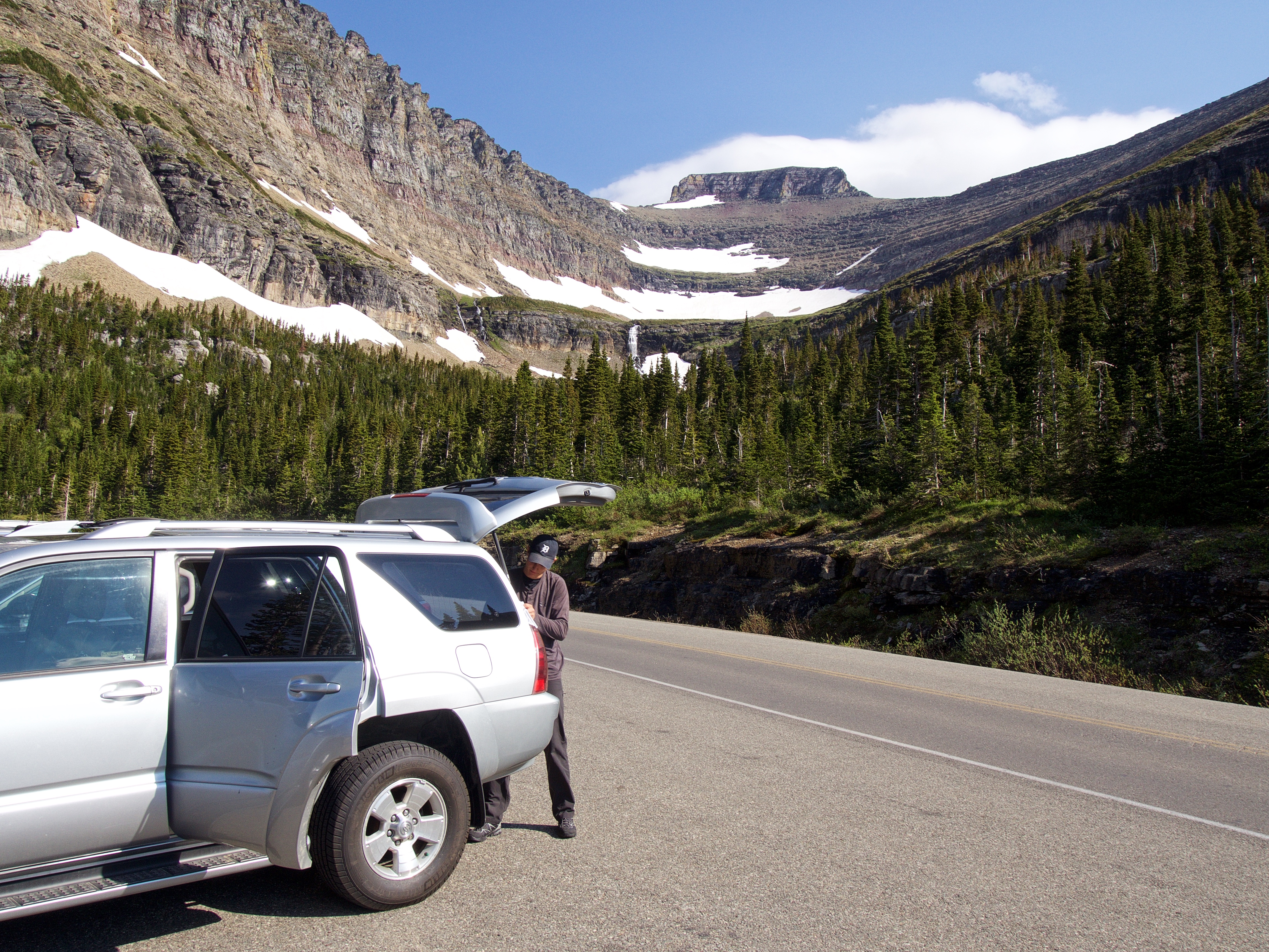
Nathan gearing up at the Lunch Creek parking area. In the background is Pollock Mountain with the southwest slopes of Piegan Mountain on the right.

The view towards Pollock Mountain from the trailhead. This is a short, but scenic approach.

There are a maze of trails near the beginning that eventually converge into a main trail alongside Lunch Creek. (Photo by Nathan McMurray)

Heading towards the large waterfall on the left.

Near the base of the waterfall, we met a friendly landscape painter who was in the process of preparing his canvas.

A blank canvas and beauty all around. Can you guess what he would end up painting? I’ll save the answer for later…

A Columbian Ground Squirrel enjoys a quick drink before scurrying off.

These bighorn sheep were enjoying the morning sunshine after spending the night binge watching European crime dramas on Netflix. 😉

I ended up being a little overdressed for Piegan, but since we were also planning for Pollock Mountain, we packed the axes and helmets. However, the class 3 couloir used by Sonny Bou and Bob Spirko to access the summit of Pollock was still snowbound, and so we aborted an attempt. (Photo by Nathan McMurray)

After carefully crossing the snow (it’s steeper than it looks!) we ascended the rocks in front of Nathan.

Nathan scrambles up, though there are faint trails that can also be followed.

Arriving at the bowl beneath Pollock and Piegan.

The gully used by Sonny and Bob to reach the saddle is the narrow strip of snow that leads diagonally up through the rock bands to the right of centre. We quickly came to the conclusion that on this day, it would be too risky to ascend.

The view back from the edge of the bowl. Heavy Runner Mountain is on the left and Reynolds Mountain is on the right. In the distance centre are Fusillade Mountain and Mount Jackson.

Since the gully to the saddle was a no-go, we turned to plan B which was to ascend directly up Piegan’s southwest slope (pictured) which is marked by a series of negotiable cliff bands. We checked out the gully on the left, but chose to ascend through an even easier route to the right of centre. If you want to avoid almost all of the cliff bands, you can go even further to climber’s right (not shown) until the cliffs almost disappear.

Nathan heads towards the gully.

Who needs a map or a GPS when there are arrow-shaped rocks to follow?

We chose to begin ascending near the centre of the picture.

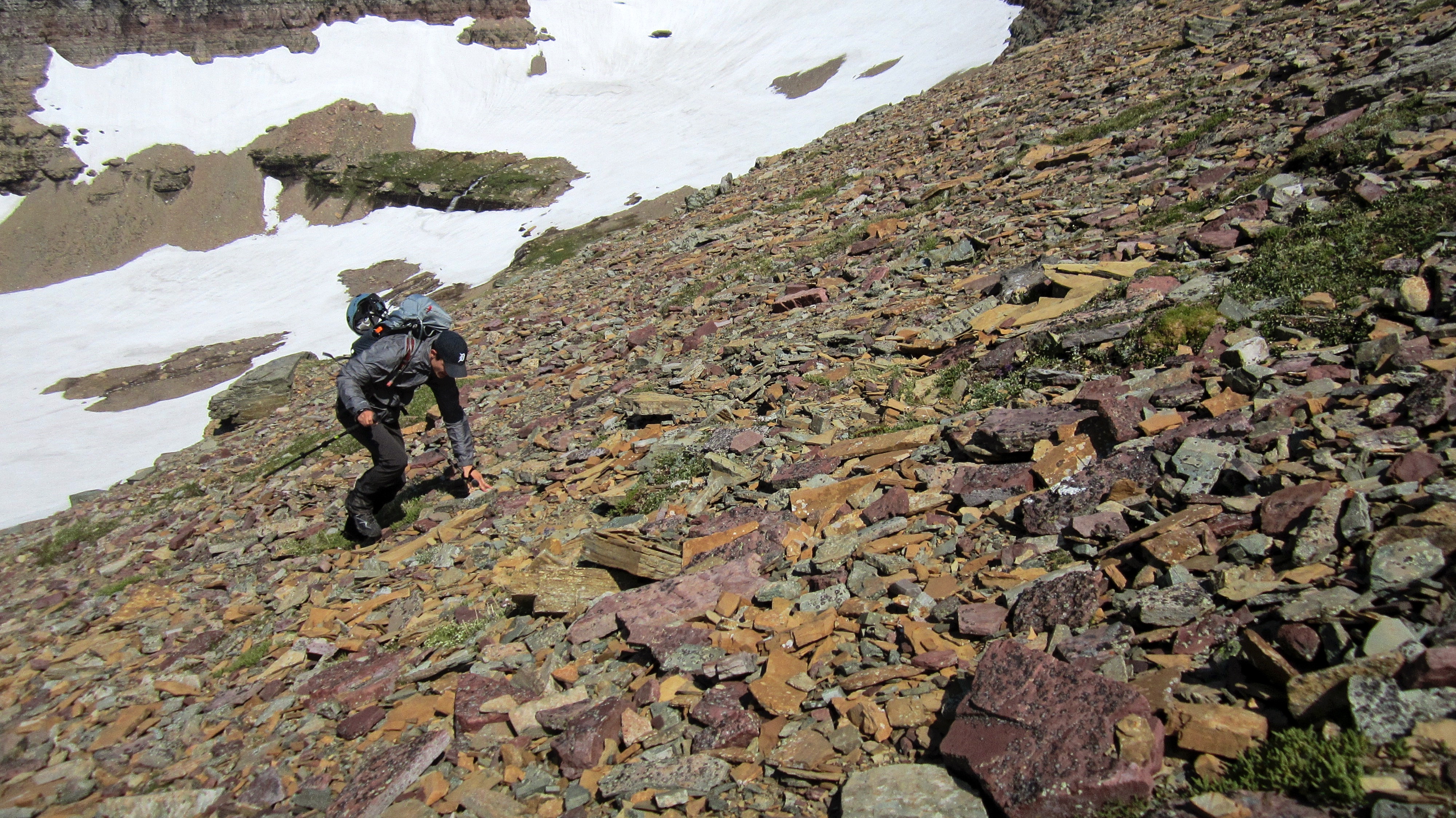
Nathan scrambles through a weakness in the cliffs. We avoided this whole section on the way down by skirting much further to skier’s left.

Lots of fun, but easy scrambling.

Piegan offers some stellar views throughout the ascent. Citadel Mountain is on the left, Heavy Runner Mountain is in the centre, and Mount Jackson is on the right. In the distant centre is Blackfoot Mountain. (Photo by Nathan McMurray)
I happened to capture the moment when a wind gust staggered Nathan. Thankfully the gusts were intermittent, but when they came, they sure packed a wallop.

Once past the cliff bands, the remainder of the route was over packed scree and rubble.

With Pollock Mountain as the backdrop, Nathan pauses to enjoy the view. I think he might be wearing George Michael Bluth’s muscle suit underneath his jacket… 😉

Some moss campion nestled on Piegan’s upper slopes.

Almost there, but we still couldn’t see the summit.

The summit of Piegan Mountain (2810m). The wind gusts were so intense when we arrived, that we had to crawl the last few metres to reach the cairn. Fortunately, they subsided to the point where we felt safe enough to stand and take some pictures.
Looking north from the summit at Mount Gould and Mount Grinnell on the left. In the distance to the right of centre are Crowfeet Mountain and Apikuni Mountain. The Piegan Pass Trail can be seen in the valley below.

Immediately to the northwest are Pollock Mountain, Bishop’s Cap (centre), and Mount Gould.

From the summit we could see that the lower section of the couloir (circled) on Pollock Mountain was still covered in snow. Edit: I’ve learned there is another class 3 couloir on the south face, just to the left of the one circled. If so, then we could’ve ascended Pollock. Doh!

Gazing west at Bearhat Mountain (far left), Clements Mountain (left of centre), and Mount Oberlin (foreground centre). Heaven’s Peak is to the right of centre.

Looking a little more to the southwest from the previous photo. Bearhat Mountain is in the centre with Reynolds Mountain on the left. Also on the distant left are Gunsight Mountain and Edwards Mountain.

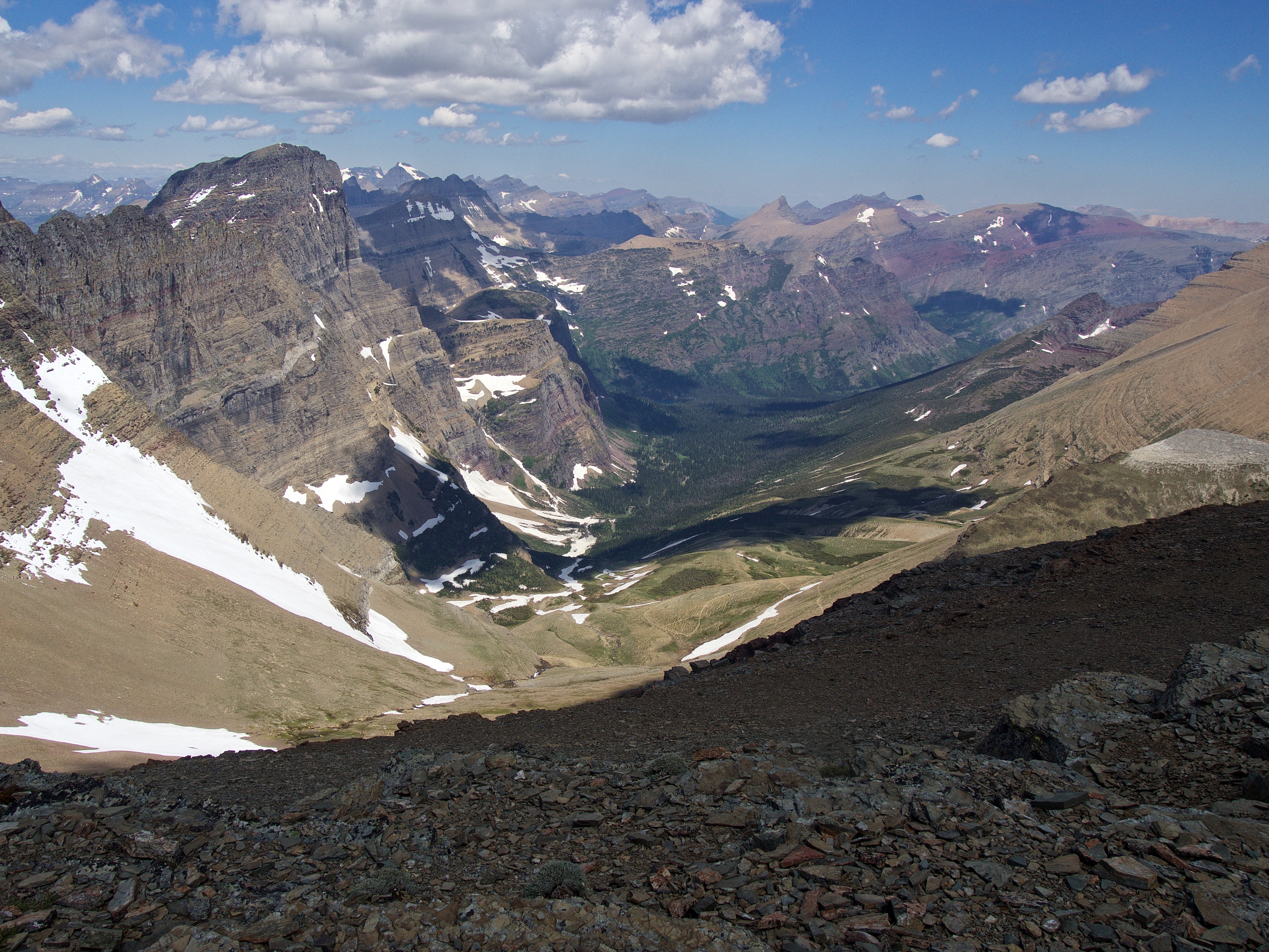
Mount Jackson (right) stands out when looking to the south. In front of it are Fusillade Mountain and Heavy Runner Mountain (foreground). Blackfoot Mountain and Mount Stimson are just to the left of centre, while Citadel Mountain is on the left.

Looking more to the southeast at Citadel Mountain (centre) and Almost-A-Dog Mountain (left).

Immediately to the southeast sits Piegan Glacier and behind it, on the left, Going-To-The-Sun Mountain. I wish I could have gotten a little closer to the edge to get a better picture of the glacier, but I didn’t want to risk it given the unpredictability of the wind. Little Chief Mountain is in the distant centre.

At 3052m, Mount Siyeh (left) fills the view to the east. On the right is Matahpi Peak and East Flattop Mountain is in the distant centre.

Always great to share a summit with your kids!

Nathan’s all smiles on the summit of Piegan Mountain.

After seeing the snow in the couloir on Pollock, there was no reason to head there, plus we couldn’t descend into the basin from the saddle because of the snow sitting in the gully. So, we decided to head directly back from the summit.

One last, sweeping view from near the summit.

Going-To-The-Sun Road and the Lunch Creek parking area can be seen below.

We swung much further to skier’s left on descent and found an easy path through the cliff bands.

We found an awesome spot to enjoy some lunch.

Alpine Forget-me-not. This might become my theme flower when I’m older and my kids begin to think it may be cheaper to leave me in the backcountry rather than put me in a home. 😉

Heading back to the bowl beneath Pollock and Piegan.

Angling towards the waterfall.

One last look at the summit block of Pollock Mountain.

Melting snow had given the waterfall a little more intensity.
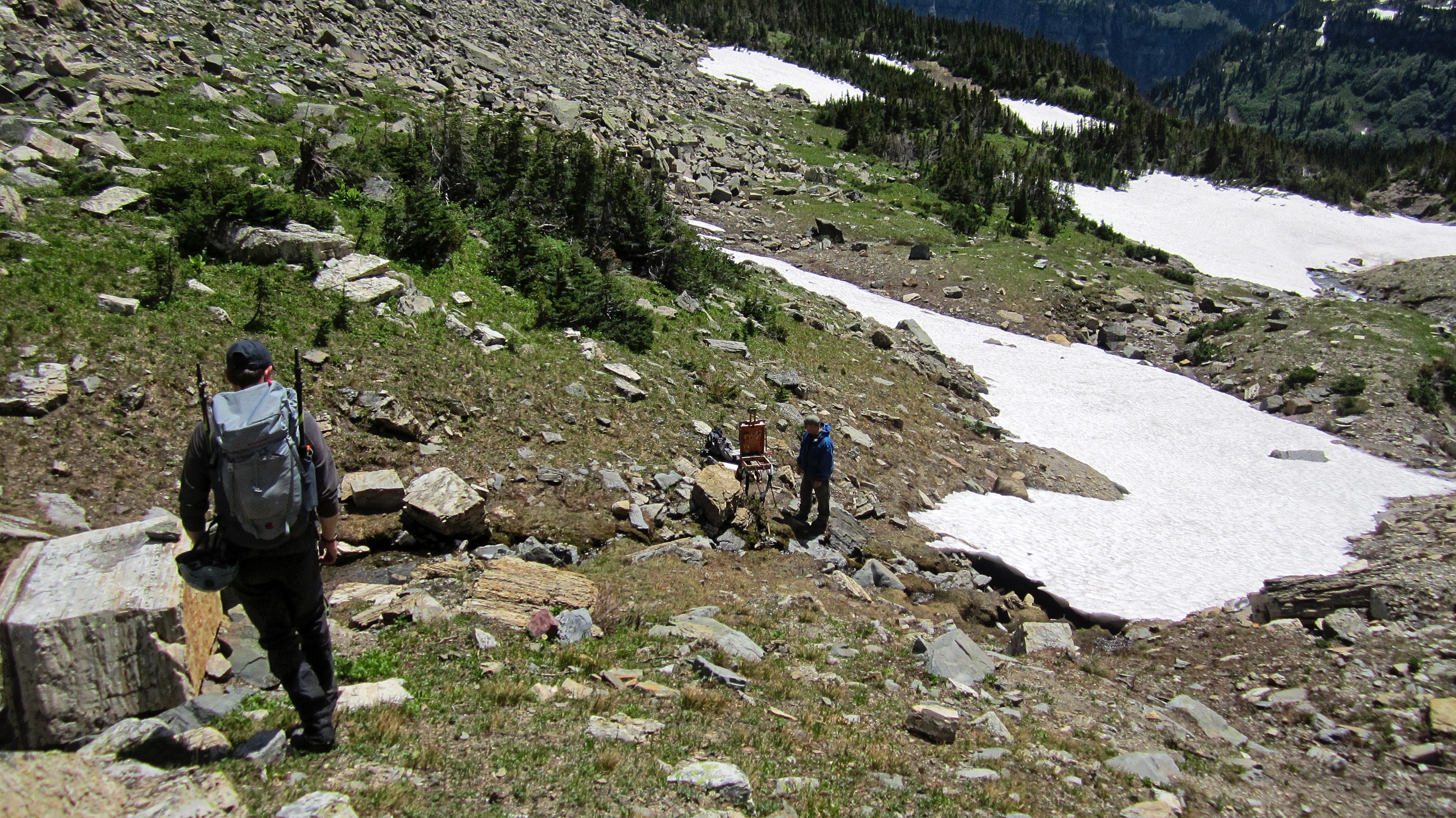
Arriving back to meet our artist friend. Now what did he paint?

I had thought he was going to compose something with the waterfall in it, but instead, he neatly captured the rock formation in front of the waterfall. When I asked about it, he replied that his next step will be to take this back to the studio and perhaps add in a bear or a sheep on the rocks. What a talented individual!

Enjoying the short trip down Lunch Creek. (Photo by Nathan McMurray)

After a round trip distance of 6.1km and a total time of 4 hours and 30 minutes, we arrived back at my 4Runner. However, our day wasn’t over…

…because we then made the drive to one of my favourite streams.

Nathan with a scrappy rainbow. I built the 4 weight 8’6″ rod he is using back when he was just 3 1/2 years-old – I know this because I smartly wrote the date on the blank, otherwise I’d just be guessing.

Releasing another little rainbow that I caught using a Sage 4 weight, 9′ that I purchased way back in the summer of 1990. This was the first graphite rod that I ever owned (I upgraded from a Fenwick glass) and I still love how it casts. For me, this was the perfect day because I was able to share both a peak and a stream with one of my kids. It doesn’t get much better than that! (Photo by Nathan McMurray)
Note to self: remember to try and expose those legs to the sun every now and then… 😉
Nice & Cool!
Thanks!