

⚠️ Hiking and scrambling are inherently dangerous activities. Please read my Disclaimer. ⚠️
With the forecast calling for windy but sunny conditions, Andrew and I once again headed out to tackle another set of unnamed foothills located on the front range of the Castle. Three weeks ago, we enjoyed an awesome ascent of the northeast end of Loaf Mountain that included “The Muffin”, “The Croissant”, and an attempt of a 2400+m peak that I’ve nicknamed, “Bakery Peak”. Today’s trip found us in the same vicinity, only across the Spionkop Creek Valley on the northeast end of Spread Eagle Mountain. Here, two distinct foothills rise from the prairie to provide excellent views of the surrounding topography. As I am again unaware of any local or Indigenous names, I’ve given them nicknames that keep with the theme of the massif: the smaller one being, “The Eaglet” (1978m; my GPS) and the taller one, “Raptor Peak” (2055m; my GPS). These are not meant to be definitive, but are simply my way of identifying them for this blog. If someone knows of a local or Indigenous name, please let me know so that I can make the appropriate changes.
The interesting thing about “Raptor Peak” is that there is a great trail that runs all the way to the top. Moreover, just beneath the summit on the north face, there is a curious pattern of lines etched onto the slope that resemble crisscrossed old roads. The trail intersects with these, but I am at a loss as to what the pattern is or what it was originally for. I also looked online at the Castle Provincial Park and Wildland Provincial Park 2018 Designated Summer Trails map, and could not see the trail listed, but it does show up on topo maps, so I’m guessing that it’s a well-known local hiking destination.
At the beginning of the day, we missed the trailhead by a couple hundred metres (I forgot to print a map) and parked at the bridge over Spionkop Creek. No worries though. We eventually found the trail, and though we had to post-hole in few spots, the snow was generally not deep enough to impede our progress. As the trail began to wind past “The Eaglet”, Andrew and I decided to leave it in favour of scrambling up “the Eaglet’s” northeast face. This ended up being a bit more involved than I was initially expecting because unlike Andrew, who chose a more sane line of attack up a gully, I found myself alongside of it and on terrain that soon transitioned from challenging to potentially treacherous given the snow. My egress then necessitated a traverse across a steep slope to rejoin Andrew in the gully. Once my heart stopped trying to escape from my chest and we found an alternate route up from the gully, it ended up being a fantastic climb. Perhaps the highlight of the day was discovering a section of magenta-coloured rock that was layered between rock covered with bright orange lichen. It was an amazing sight to see and I’d love to return early on a summer morning to see what it looks like when it is illuminated by the sun.
The trip from “The Eaglet” to “Raptor Peak” was easy and if it wasn’t for the insane wind, the summit would’ve been a great place to linger and enjoy the views. Indeed, because there is such a great trail, these would be great little peaks to flock to anytime during the year. When the conditions are right, it is also possible to follow Andrew’s route along the connecting ridge to the summit of Spread Eagle Mountain.
As usual, the Castle never fails to inspire me. Whether it’s a big mountain or an outlying foothill, there is always something unique to find or experience here. Again, and as always, it was awesome to be out with Andrew who is probably the best ambassador for exploring the Castle that there is. Be sure to read his awesome trip report!

To get to the trailhead, drive ~19.5 km south from Pincher Creek on Highway 6 until you reach the Shell Waterton Plant Road (Township Rd. 43A). Turn onto it and drive west for ~9.1 km until you come to a junction with a gravel road near to the entrance of the plant. Turn left and onto the gravel road and continue for ~3.9 km until you reach Butcher Lake. Turn left and onto another gravel road immediately prior to the Lake and follow this road for ~1.4 km until you come to the junction with another road on your left. Turn here and follow it for ~5 km until you arrive at a T-intersection. Turn left again and proceed for 700m until you see a hairpin curve on your right. Follow the curve and drive for ~3.5 km until you reach yet another T-intersection. Turn right and drive for ~800m until you reach a fork in the road. Keep left and drive for another ~445m until you come to a large bend in the road. This is the start of the actual trailhead.
We ended up missing the real trailhead, and so we started at the bridge and followed Spionkop Creek, looking for the trail. After ~513m we thought we spied a trail in the trees to our left and so we left the creek and ascended the bank. From here we headed south looking for the trail and after another ~518m we finally found it. Once on the trail it was a relatively pleasant hike – except for a few sections of post-holing and a short section of bushwhacking after we temporarily lost the trail – for ~850m until we reached a clearing near the NE base of “The Eaglet”. Here we left the trail and made our way for ~218m to the start of a gully. A short, but fun scramble brought us to the top of the ridge. Another hike of ~450m that included a brief drop back onto the NE face to check out some amazingly coloured rock, brought us to the summit of “The Eaglet”.
From “The Eaglet” we then hiked ~900m SW to the summit of “Raptor Peak”. This included a ~70m elevation loss to the col, followed by a ~145m elevation gain. We decided to descend using the NW ridge and see if we could make it directly back to Spionkop Creek without using the trail. Unfortunately, this did not prove feasible and so we cut back to the NE and bushwhacked until we regained the trail. On our way back, we followed the trail all the way back to the creek, where we again left it to retrace our route along the creek to our vehicles.

The black arrow shows the start of the actual trailhead. It looks like it would be a ~445m hike from the trailhead to reach the creek crossing. The trail then resumes on the other side.
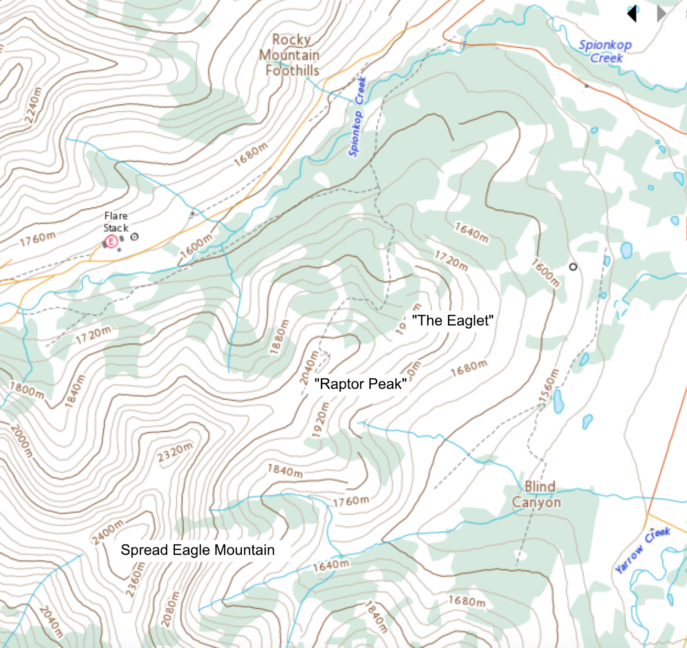
As with all of the nicknames that I use, “The Eaglet” and “Raptor Peak” are not meant to be definitive. There may very well be a local or Indigenous name that I’m unaware of. I chose these two names because they relate to nearby Spread Eagle Mountain. The topo also shows the trail that leads to the summit of “Raptor Peak”.
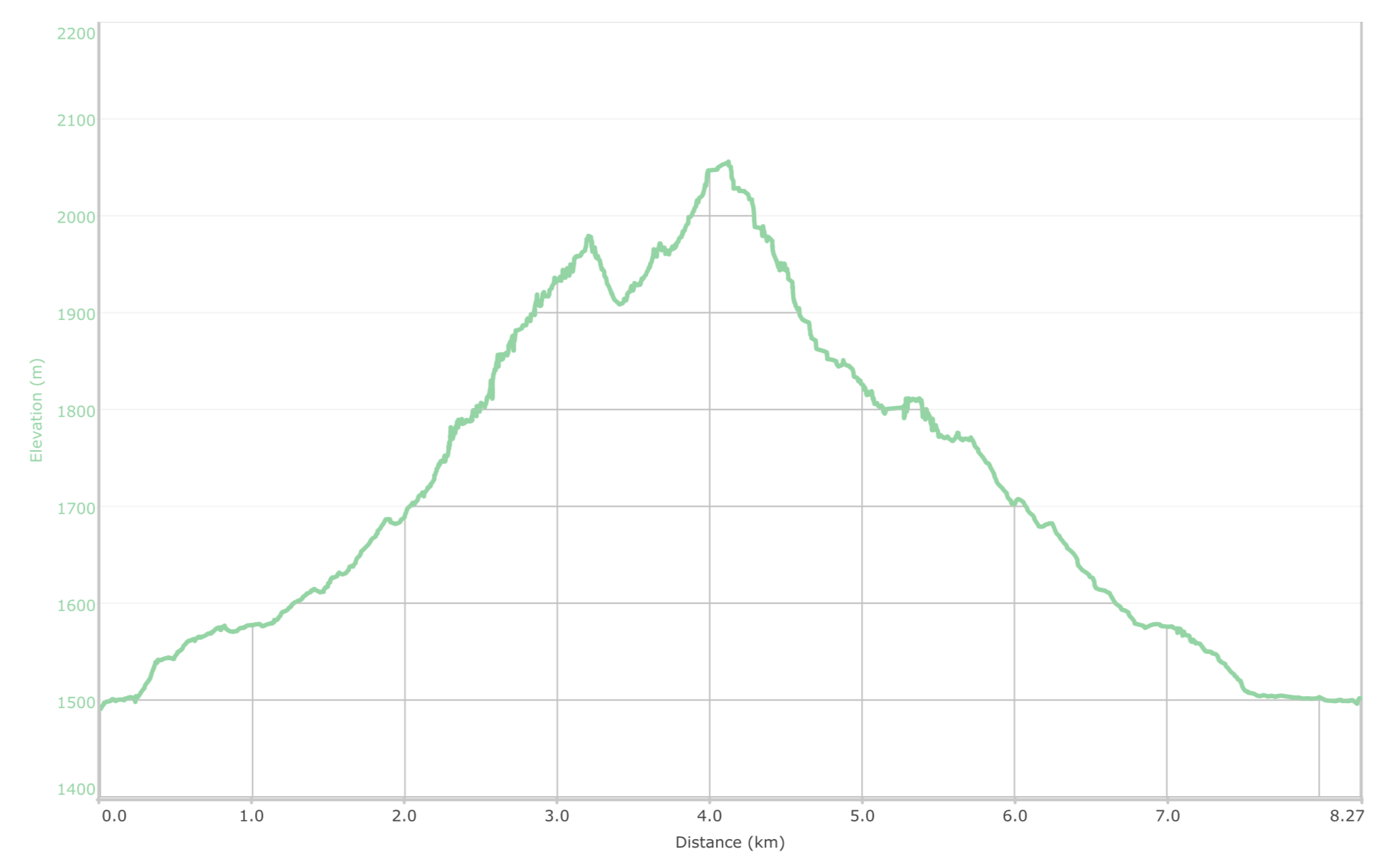
I forgot to start my GPS until we were ~280m into the trip. The insane wind also messed with its readings, so my elevation readings may be somewhat spurious. Our total roundtrip distance was ~8.55km with total elevation gains of ~696m. Our total time was 4 hours and 31 minutes.

Andrew took this pano of Spread Eagle Mountain (left), “Raptor Peak” (centre) and “The Eaglet” (right) as he drove in from the east. Our route would scramble up the northeast face of “The Eaglet” which is skyline on the far right. (Photo by Andrew Nugara)

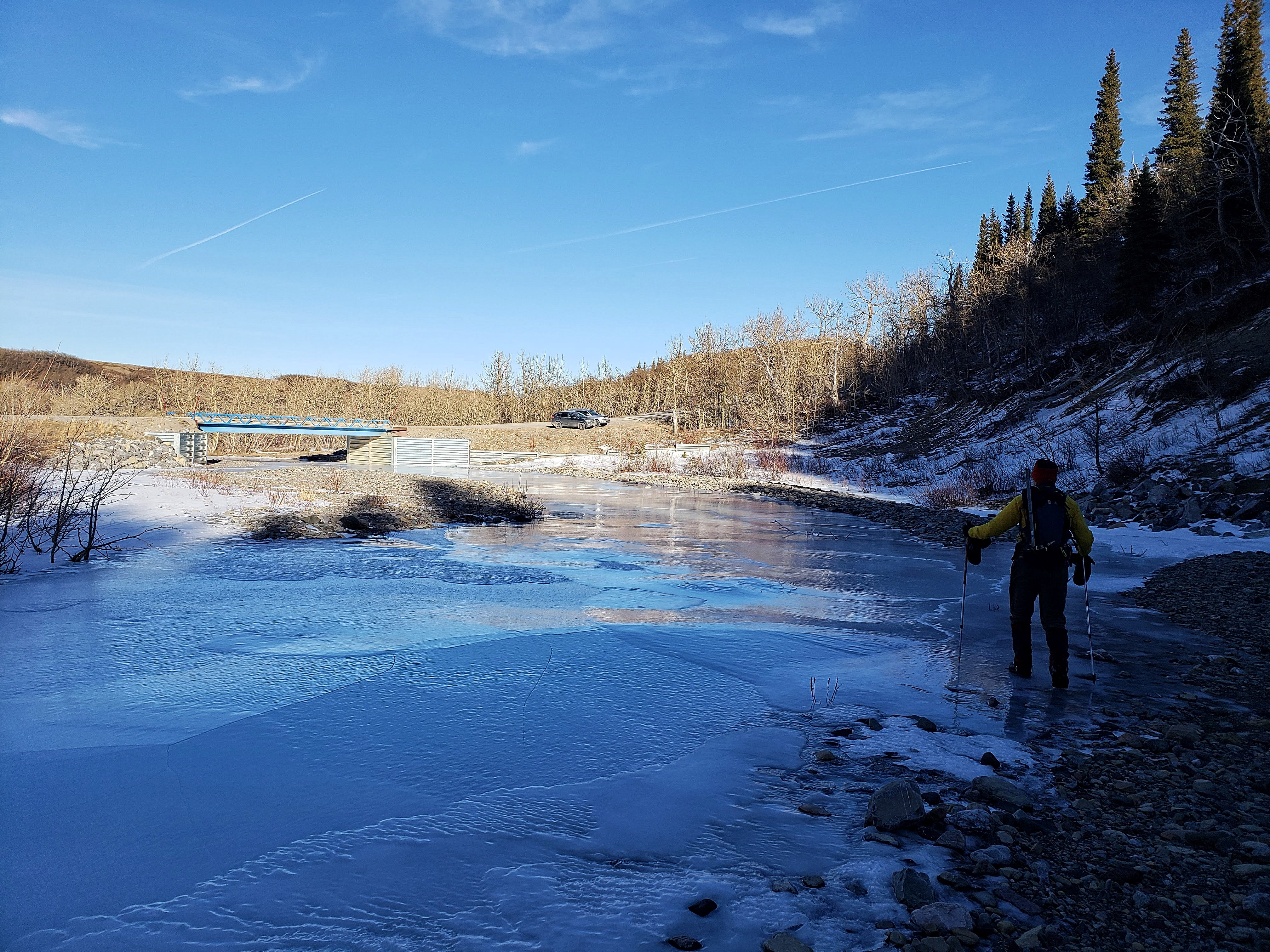
Gearing up at the bridge over Spionkop Creek. Unbeknownst to us because I did not bring a map, the actual trailhead begins at the bend in the road that can be seen in the distance on the right. “Bakery Peak” is in the centre.

Another awesome pano by Andrew that features a frozen Spionkop Creek with “The Muffin” in the background. (Photo by Andrew Nugara)

The entire creek was frozen in a thick, glossy sheet of ice. A pair of skates would’ve been awesome!

Approximately ~513m from the bridge, we thought we spied the trail in the trees to our left. Unfortunately, this was not it but we climbed to the top of the bank (left) anyway and kept walking south until we eventually found it. Had we continued another ~100m and around the bend in the creek (centre), we would’ve come to the point where the actual trail crosses Spionkop Creek.

Shortly after leaving the creek, Andrew follows what we thought was the trail.

Looking back to the creek from near the top of the bank.

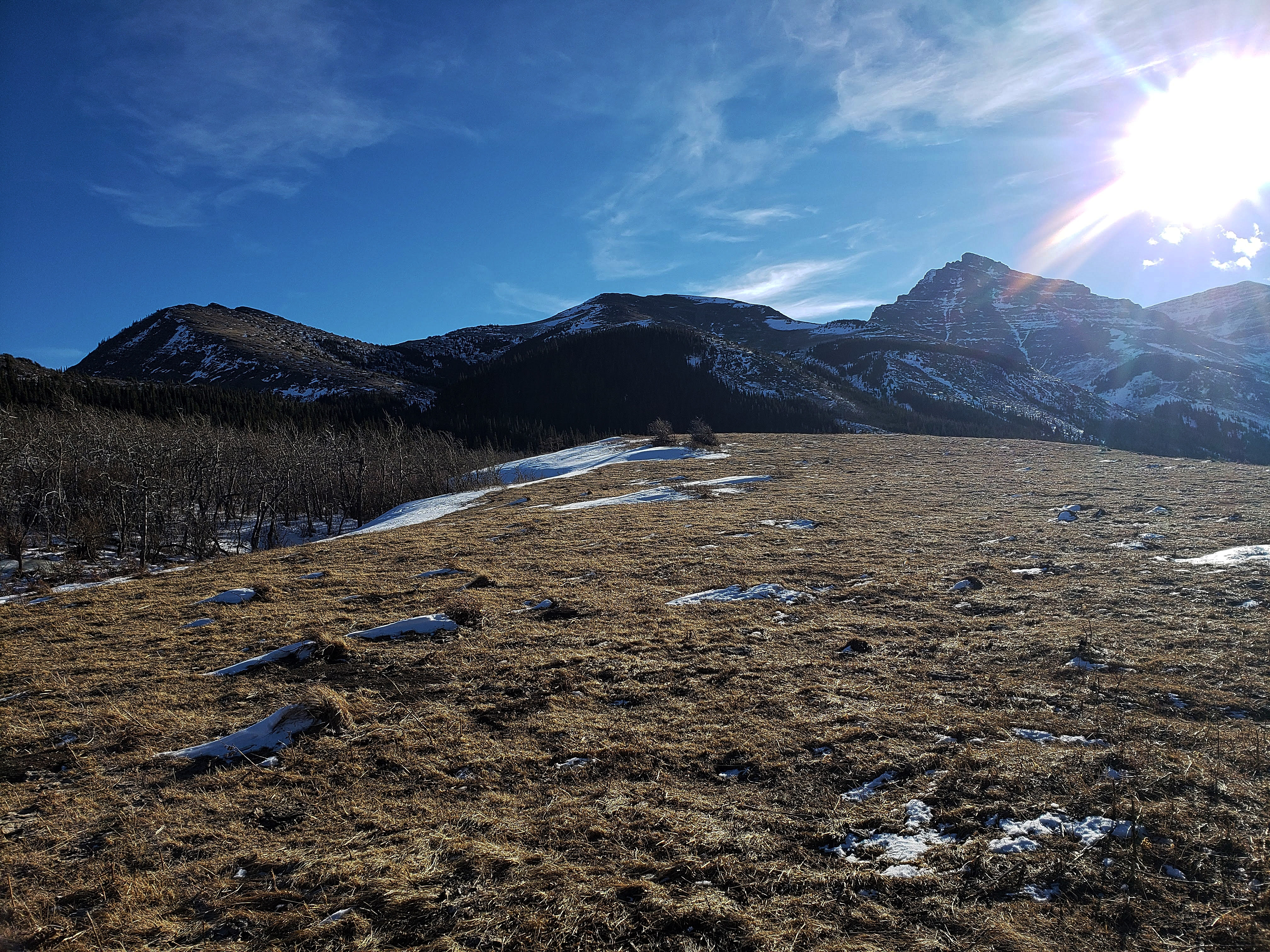
Following the bank and enjoying a great view of “The Eaglet” (left), “Raptor Peak” (centre), and Spread Eagle Mountain (right).

Andrew checks out “The Muffin” (right), “The Croissant” (centre), and “Bakery Peak” (left).

Looking back towards “The Muffin” after finding the trail (right).

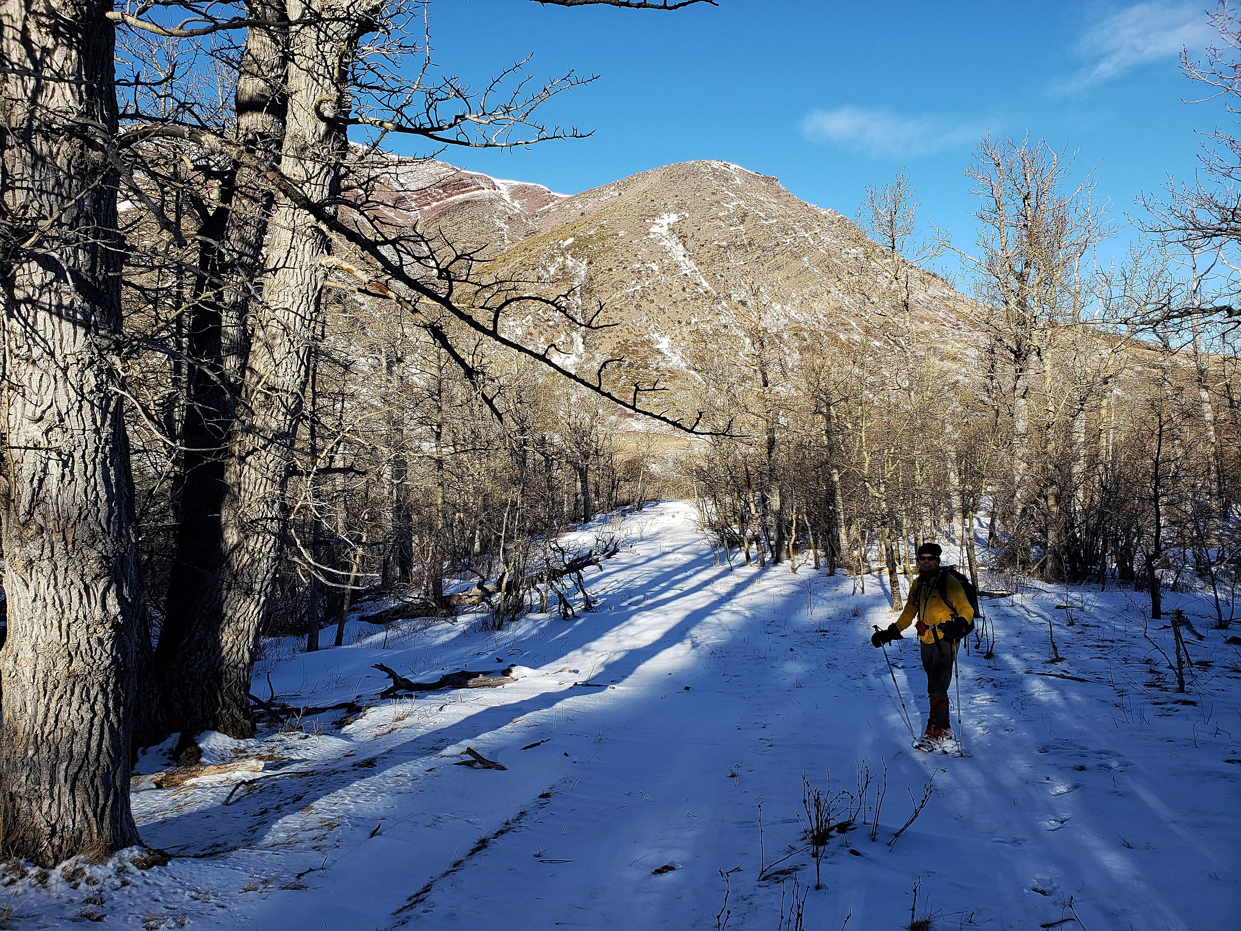
Though covered in snow, the trail cuts a wide swath through the trees.
Looking back at Andrew as we follow the trail.

A moose had done most of the post-holing for us. Thanks Bullwinkle! 😉

After losing the trail briefly in a small clearing, we ended up bushwhacking for a short period before finding it – and the moose tracks – once again.

“The Eaglet” can be seen in the distance as Andrew follows the well-defined trail.

Our first clear view of the northeast face of “The Eaglet”.

We followed the trail until we came to a clearing that provided direct access to the northeast face. Our route started up next to the snow-filled gully in the centre.

Lots of options for scrambling.

The view back to the trail (centre) from near the gully.

Andrew heads up to the gully. The terrain is much steeper than it looks!

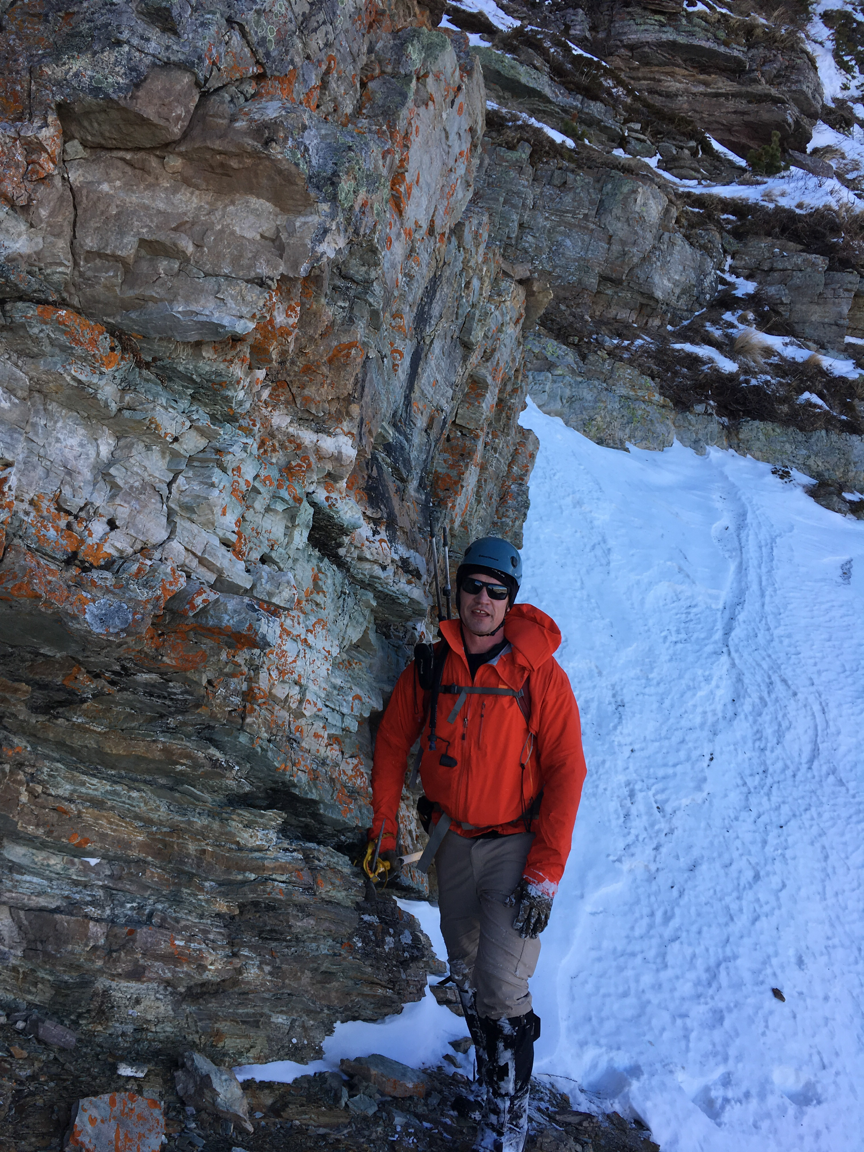
My route went up this short cliff band and between the two large rocks in the centre.

Nearing the top of the cliff band from the previous picture. (Photo by Andrew Nugara)

Once on top, I headed up this packed snow slope and through the gap next to the tall tree in the centre. From this perspective it looks fairly benign – and that’s what I thought as I started – but it didn’t take me long to discover that the gap itself was much steeper than it appeared.

Here is the actual angle of the snow slope as I stand at its base. My location in this picture is the same as the previous picture. (Photo by Andrew Nugara)

Looking over at Andrew as he takes pictures of the rock on the other side of the gully.

I (far left) kick-step my way to the top of the snow slope and the base of the gap in the rocks. (Photo by Andrew Nugara)

At the start of the gap and wondering what I’ve gotten myself into… 😉 It took a few careful moves to reach the top and once there, I discovered to my dismay, that the terrain became even more treacherous. I then began to slowly traverse towards Andrew who was now above me and trying to find a route up the final half of the gully. (Photo by Andrew Nugara)

Traversing above a series of small cliffs. (Photo by Andrew Nugara)

Andrew looks for a route up the second half of the gully. Again, the terrain is much steeper than it looks. We eventually decided that it was easier to exit the gully via a ledge that was located directly to climber’s left.

Traversing across the gully to join Andrew the other side. (Photo by Andrew Nugara)

Leaving the gully via a small ledge. (Photo by Andrew Nugara)
An orange-jacketed dodo. 😉 (Photo by Andrew Nugara)

Andrew checks out better options for ascent on the other side of the gully.

Heading up good rock. (Photo by Andrew Nugara)

Andrew follows me up.

On top of the ridge and being pummelled by the wind. We would soon drop back onto the northeast face in search of reprieve.
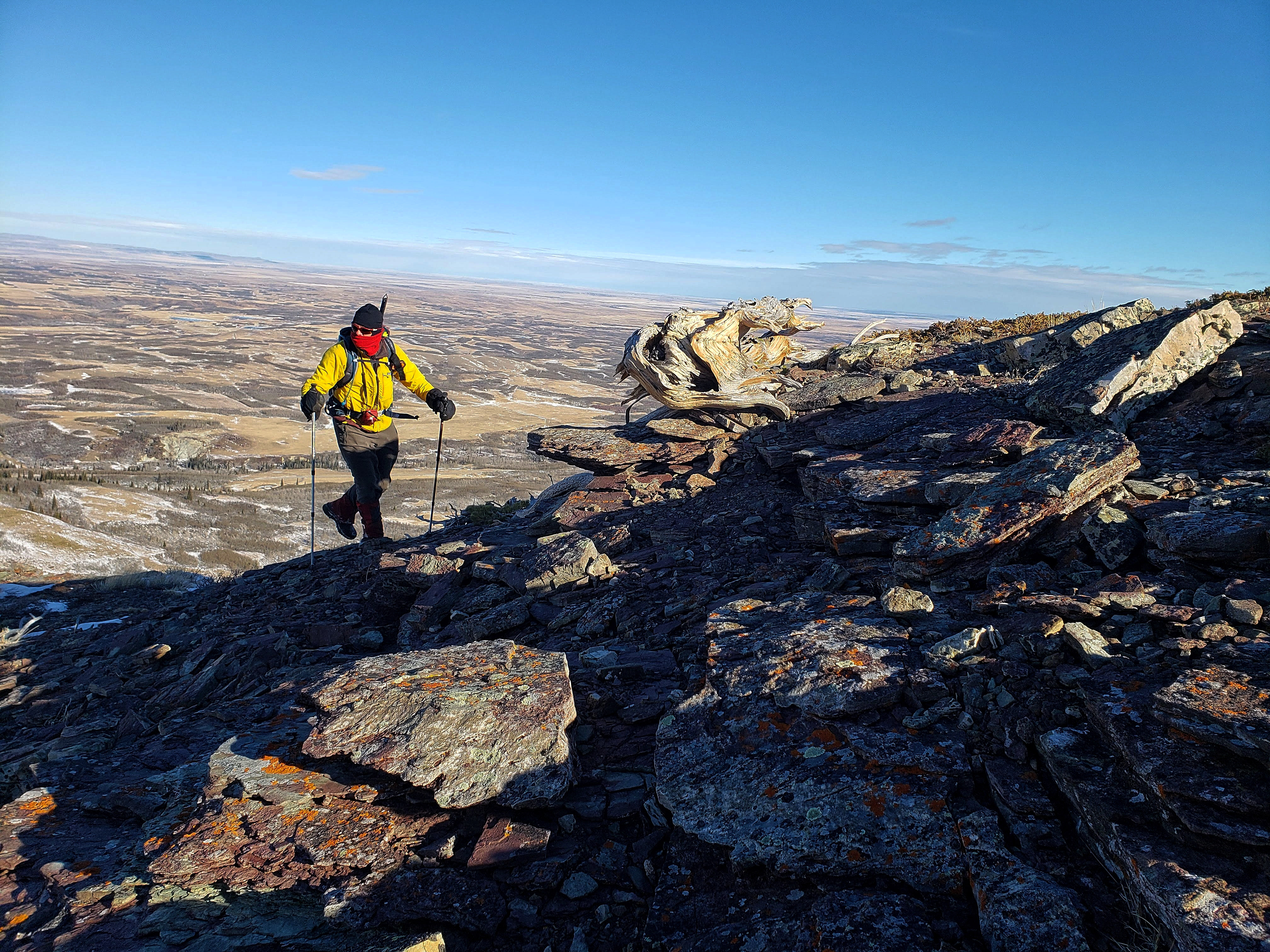
Andrew passes an interesting old tree.

A closer view of the tree. In the background are the Porcupine Hills.

A cool shot by Andrew as I make my way up the ridge. (Photo by Andrew Nugara)

Looking to the southwest at Spread Eagle Mountain (far left) and “Raptor Peak” (centre left). The trail can be seen on the on the lower right.

Prior to the summit, we dropped back onto the northeast face to get out of the wind – and to check out some amazingly colourful rock.

We were captivated by layers of magenta-coloured rock. If only the sun were shining on this spot!

The Castle is so colourful!

Intense orange lichen.

Magenta rock sandwiched between lichen-covered rock.

The colours were so vibrant that we took our time (and about a billion pictures) just to try and capture the intense beauty of this place.

Ninastako and Lakeview Ridge (foreground) from the northeast face of “The Eaglet”.

Andrew finds the optimal angle to photograph a section of rock – that or he is re-enacting a scene from the Matrix. 😉

A gust of wind staggers Andrew as we draw close to the summit.

Andrew chirps me from “The Eaglet’s” summit (1978m my GPS). 😉

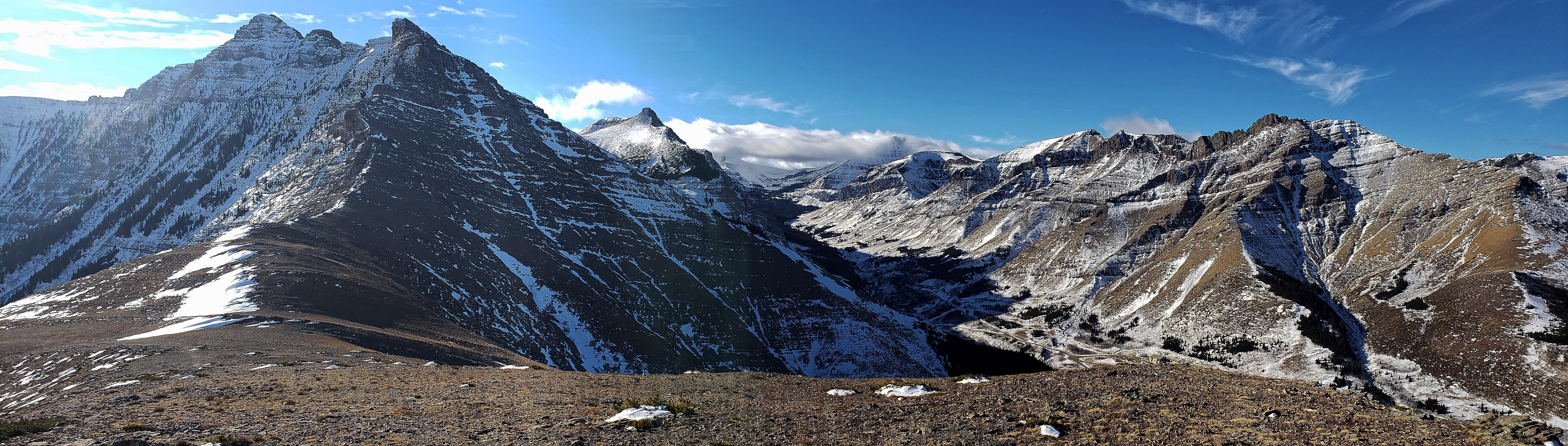
The view slightly to the southwest with Mount Yarrow on the left, Spread Eagle Mountain in the centre, and “Raptor Peak” on the right. Perhaps fittingly, a beclouded Cloudy Ridge sits behind Mount Yarrow.

The view to the southwest at Spread Eagle Mountain and “Raptor Peak”. The other wingtip of Spread Eagle can be seen in the distance behind “Raptor Peak”.

The view west at the cloudy summit of Loaf Mountain (left of centre) and “Bakery Peak” (right of centre). The trail that leads up “Raptor Peak” is clearly demarcated in the trees to the right of centre.

Gazing northwest at “Bakery Peak” (left), Drywood Mountain (centre), “The Croissant” (right of centre), and “The Muffin” (far right). Mmmmm those were delicious peaks!

Cue up the Steve Miller Band cassette, because Andrew’s going to fly like an eagle. 😉 Ninastako (Chief Mountain) is in the background on the left.

It was WAY too windy to even attempt building a cairn. So I will simply designate these rocks as the cairn and give it the name, “Sam”, after the famous Muppet character, Sam the Eagle. 😉 (Photo by Andrew Nugara)

Andrew leaves the summit as we begin the ~900m hike to “Raptor Peak”. The elevation loss to the col was ~70m followed by a ~145m elevation gain.

Andrew wings our way up the false summit.

Looking back at “The Eaglet” and the orange-jacketed dodo. (Photo by Andrew Nugara)

On the way over, I noticed that my right foot was getting a bit cold and that my sock felt like it was bunched up… I must’ve been clenching my toes too tight during my sketchy traverse earlier in the day! 😉 (Photo by Andrew Nugara)

Andrew approaches the false summit as the audience holds its collective breath.

The summit of “Raptor Peak” (2055m my GPS).

Andrew makes the short hike between the false summit and the true summit.

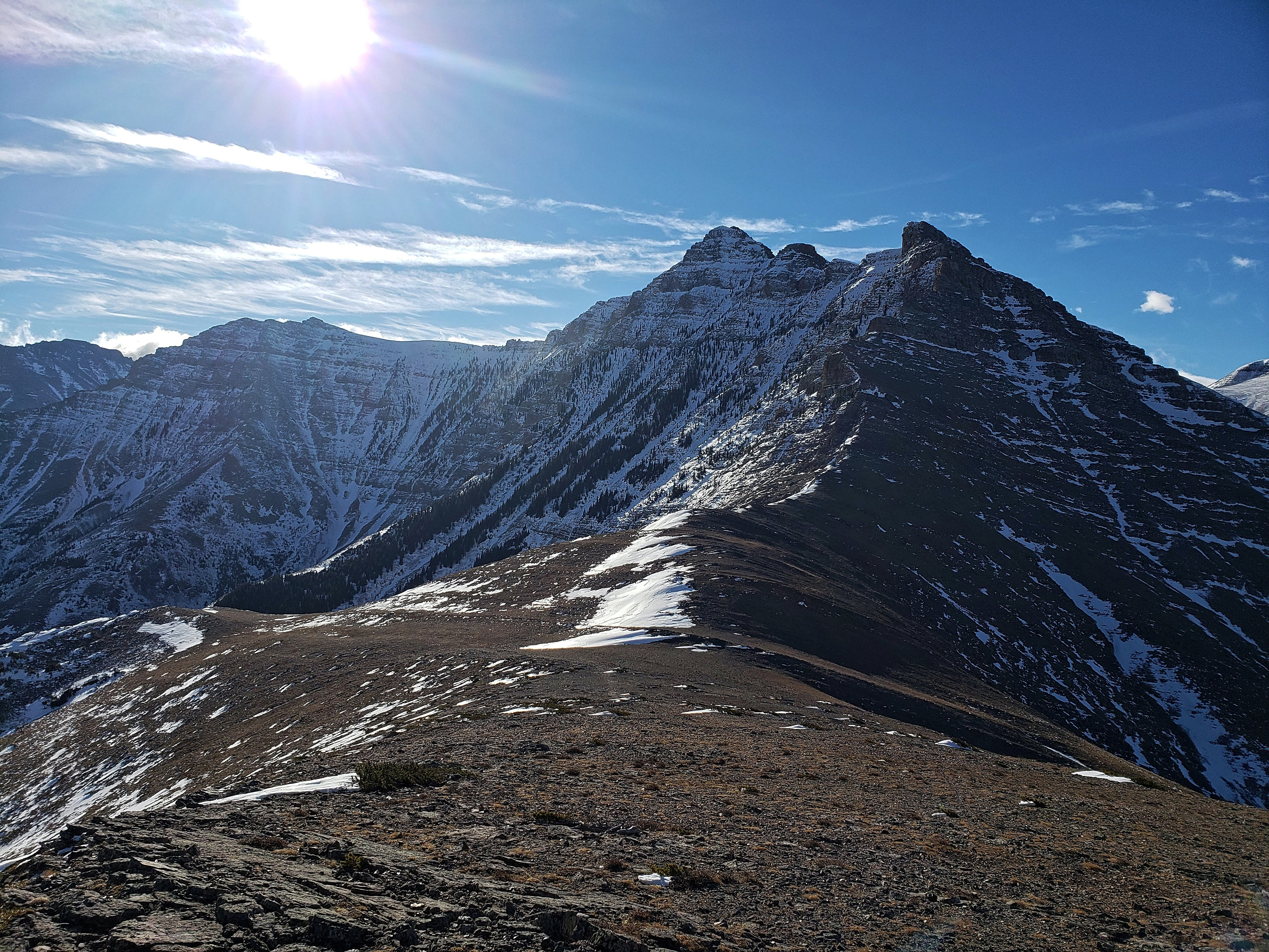
A pano to the south and southwest.
A pano to the west.
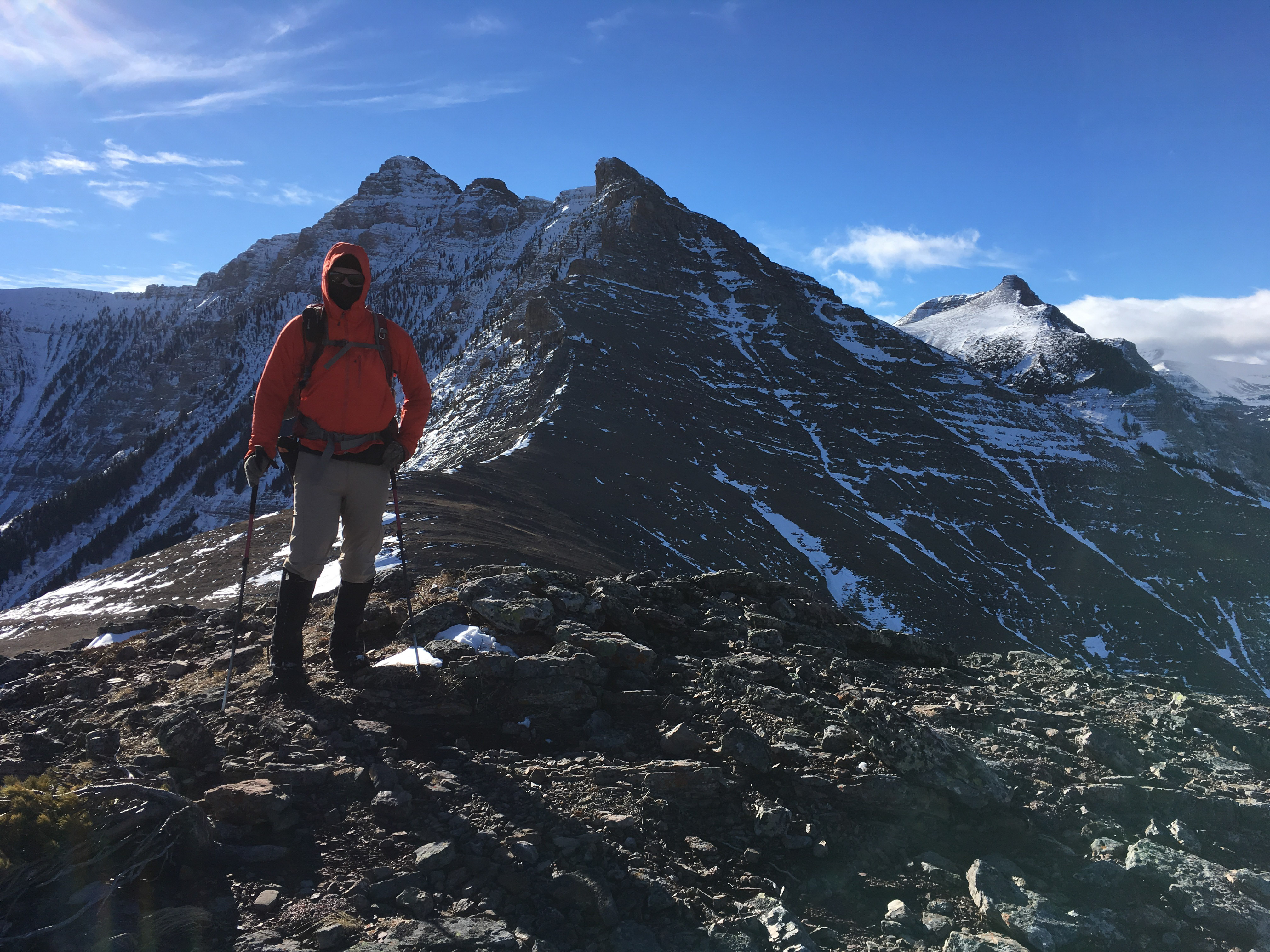
Mount Yarrow (left) and Spread Eagle Mountain (centre).

The view west towards the unnamed high point (centre) on Spionkop Ridge that functions as the other wingtip for Spread Eagle Mountain. Loaf Mountain is on the far right.

A more comprehensive view to the west of all three high points on the Loaf massif. “Bakery Peak” is on the right.

Looking north at “Bakery Peak” (left), Drywood Mountain (centre), “The Croissant” (left), and “The Muffin” (far left). In the distance behind “The Croissant” is the summit of Prairie Bluff.

This was Andrew’s second time on the summit. The last time he was here, he followed the connecting ridge to the summit of Spread Eagle Mountain.
I found the remnants of a small cairn. It’s really too bad the wind was so nasty, because it would’ve been a great place to build a nest and eat lunch. (Photo by Andrew Nugara)

Preparing to unfurl my wing suit. 😉 (Photo by Andrew Nugara)

On descent, we decided to try our luck by following the north ridge as far as we could, hoping that it would lead directly back to the creek. (Photo by Andrew Nugara)

We were also curious to check out the distinctive lines that are etched onto the north face of the mountain.

We followed the ridge until we came to the trees on the lower right. Here, we determined that there was not a direct route to the creek and that it would be much easier to bushwhack our way back to the trail.

A closer look at our descent route off of “Bakery Peak” three weeks ago.

Outside of the intense wind that kept knocking us off balance, descending directly down the ridge was not difficult.

The trail is the lower line and from there, it looks like you could follow any of the other lines to the top. I’m not sure what these lines are, or why there are so many of them. X marks the spot…? Edit: Trent (see comments below), believes that this was once the site of a copper mine. I will have to do some more investigations, but this would make sense. Thanks Trent!

We came across this twisted old tree on the way down.

The lower left side looked like it had been shaped into the head of an eagle. Rather fitting I would say!

A better view of the markings beneath the summit…

…and a telephoto of the same. Notice the alien saucer in the sky above… 😉

Our plan to descend the north ridge directly to the creek was not feasible, so we began to head towards the trail. (Photo by Andrew Nugara)

That moment when you wonder why you left your snowshoes back in the car. 😉

Andrew leads the way across open slopes as we head towards the trail. In the background is “The Eaglet”. Here’s a life hack for hiking in deep snow: tell the person you are with to go in front because it would make a great picture. Keep telling them to go further and then further because you need to perfect the composition. Then simply follow their tracks and profit. 😉

Back on the trail and at the point where we had left it earlier in the day to reach the base of “The Eaglet”.

We made quick time on the way back. The quality of the trail would make this a great snowshoe trip or a pleasant summer hike. I couldn’t find it on the Castle trail map, but it is on topo maps, so I’m thinking that at the very least, it’s a local hiking spot that people flock to. 😉

Curiously, the well-trodden trail disappeared completely just prior to Spionkop Creek.
Looking back at “The Eaglet” (left) and “Raptor Peak” (centre).

Andrew arrives back at Spionkop Creek. The trail can be seen continuing on the other side.

Looking back along the trail from the creek.

We decided to follow Spionkop Creek back instead of following the trail to the trailhead. The cool thing was, we could push with our poles and the wind would help us slide through many sections.

This rock looked like it had been hand painted.
Arriving back at our vehicles after ~8.5 km and 4 hours and 31 minutes. This was a great trip, though I don’t think either of us were expecting “The Eaglet” to throw us such a fun challenge. Much like their neighbours across the valley, these two feathery foothills are worth visiting either as part of a longer day, or as destinations in and of themselves. I’d love to return on a clear, summer morning to see what the magenta-coloured rock looks like when it is illuminated by the sun. The Castle is such an awesome place!

One last look at my poor winter hiking boot. R.I.P. friend.
Hello, Thanks for your excellent trip reports. I’ve been greatly enjoying them lately.
My understanding is that the switch back trails up the side of spread eagle are from an old copper mine. Some of the rocks contain blue copper ore when hiking there in the summer.
Cheers
Trent S
Hi Trent, thank you so much for the information! That would make sense, because the pattern definitely has an industrial feel to it. I will have to go back when there the sun is shining on it and check to see if I can find that blue copper. Do you happen to know what the name of the mine was and when the dates when it was operational? I will do some digging as well. Again, thank you so much and happy hiking!!
Hi Dave, I don’t have any other information about the mine. I believe it was quite small and only used by local pioneers. I’d be curious about how the ore was refined. I’m in Pincher so I will ask around and see if anyone from the area has info.
Cheers
Trent
That is really interesting. I did a quick search through government records for abandoned copper mines and the only one in the area that came up was the one in Waterton. That being said, it was a quick search, so I will go back and run through it again. Thanks again for the information and for asking around in Pincher. Let me know if you find anything and I will keep ‘digging’ (pardon the pun) on my end.