

⚠️ Hiking and scrambling are inherently dangerous activities. Please read my Disclaimer. ⚠️
With the summit of Loaf Mountain now under our belts, we set off on an enjoyable hike over to the summit of Spionkop Ridge which lay 3.5km to the south. This is the view from the western slopes of Loaf Mountain along the connecting ridge to Spionkop Ridge (distant left).

Nature’s version of grafitti.

Looking back to the false summit of Loaf Mountain from the west.

Traversing the the connecting ridge was an enjoyable experience.
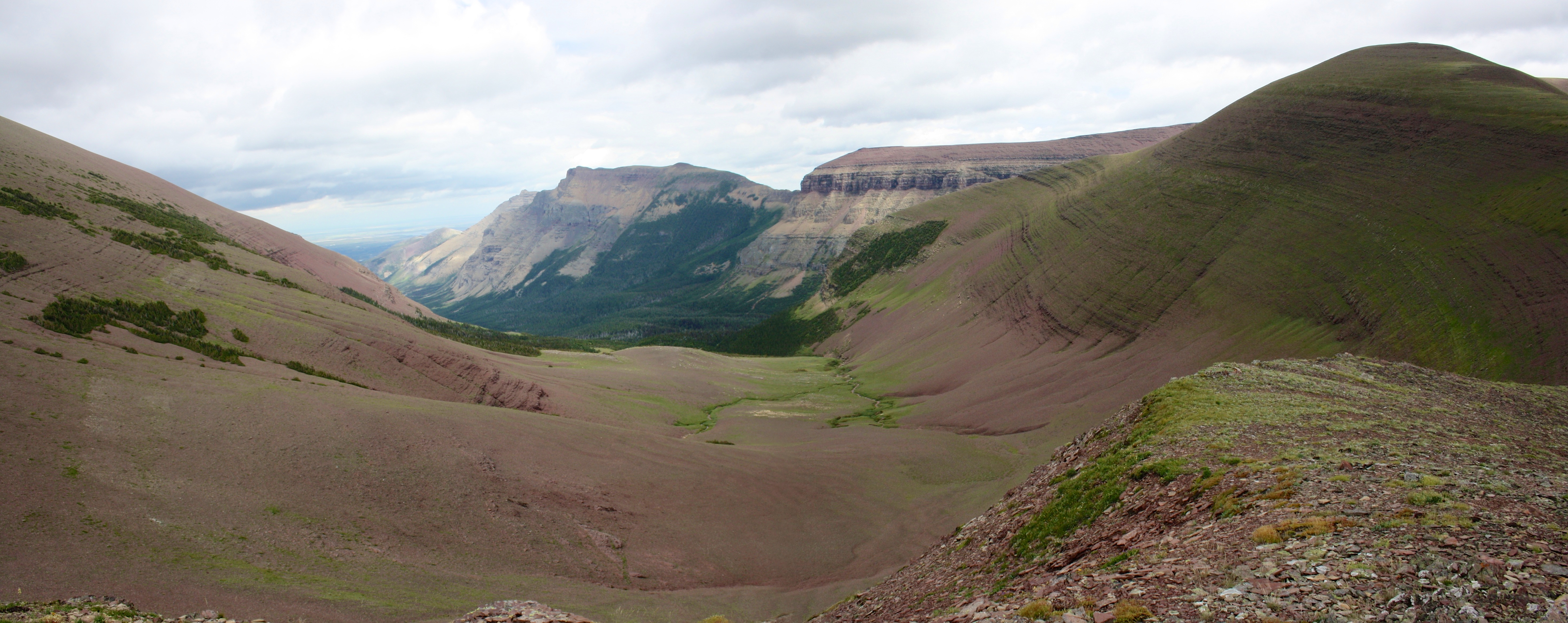
A view of the moon-scape valley between Loaf Mountain and the high point on the connecting ridge.

Jeff makes his way along the ridge to Spionkop. The summit of Loaf Mountain is in the background.

Looking ahead to Spionkop and the scrambling that awaits. The slopes are quite steep and some route finding is required.

Looking down the Spionkop valley. This is simply one of the most amazing mountain views that I have ever seen. I wish I could have fully captured the grandeur of it with my camera.

Looking up the slopes of Spionkop. The scrambling is not difficult but a bit of route finding is required.

Looking into the valley. It was just that amazing. The summit of Drywood Mountain can be seen in the distance on the left.

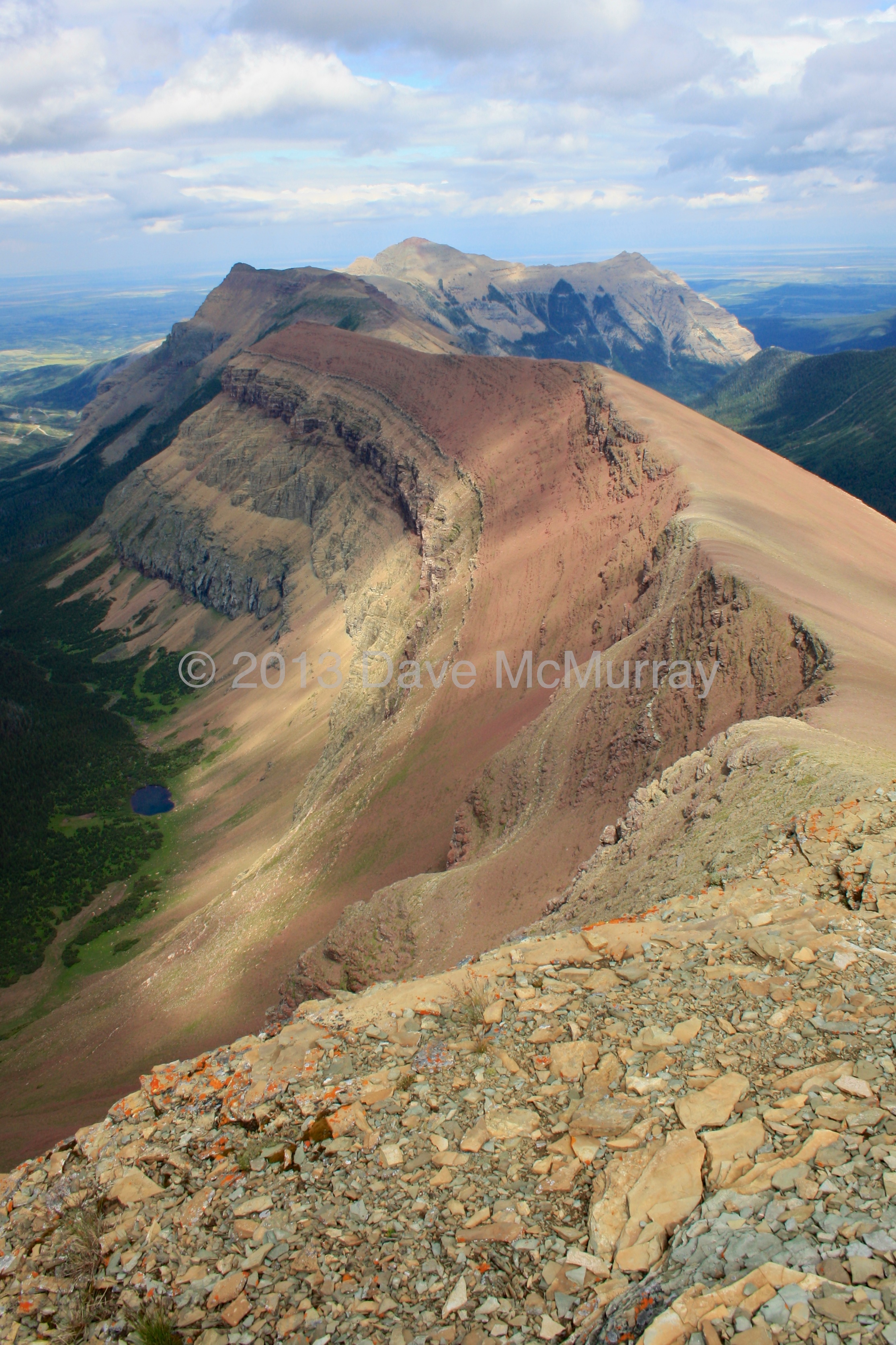
The summit of Spionkop finally comes into view. Newman Peak and Avion Ridge in Waterton National Park are just to the right of centre and not too far away.

Jeff comes onto the summit block. Loaf Mountain is in the background on the right.

The view northeast with Loaf Mountain in the centre. Victoria Peak can be seen on the left and Drywood Mountain on the right.

The view to the west. In the foreground is Sage Mountain.

And yet another view of the Spionkop valley. The sun actually started to shine after a day that began with snow and rain. The summit of Spread Eagle Mountain is on the far right.

Looking southeast from the summit of Spionkop.

The view to the south west.

The view south from the summit. It would be an easy hike to Newman Peak and Avion Ridge from Spionkop.

And another view of the Spionkop valley….

There are some unique circular patterns on the ridge between Spionkop and Newman Peak.
Looking down Spionkop Ridge toward Spread Eagle Mountain (Mount Roche). It looks like you could hike this as well.

Jeff becomes contemplative on the summit….

…while I do some one-handed pushups. 😉

My GPS reading on the summit of Spionkop.

Heading back.

One last view.

Jeff scrambles down Spionkop’s slopes.

The view below us and to the west as we make our way off of Spionkop.

Looking back toward Spionkop from the connecting ridge.

We sidesloped Loaf Mountain to reach the col above Bovin Lake.

The col above Bovin Lake and Loaf Mountain. We would follow this valley back to our vehicle.

Looking down the valley toward the Southwest Summit of Drywood (left) and Drywood Mountain.

Following the trail as the evening sun highlights the Southwest Summit of Drywood.

Our ascent drainage and the slopes of Loaf Mountain are on the right. We didn’t see a bear all day until the last 1.5 km. A large black bear was on the trail but took off as soon as he heard/saw/smelled us coming. Yelling ‘Oiler’s Suck’ is my favorite bear deterrent though after almost 22km of hiking, I’m sure he smelled us long before he heard us.

A Venus Tree Catcher…

Looking back from the road. The summit of Loaf Mountain is in the distance on the right and Spionkop Ridge is on the far left. The eastern section of Loaf is in the middle. Sumitting these two peaks was a day well spent.


Leave a Reply