

⚠️ Hiking and scrambling are inherently dangerous activities. Please read my Disclaimer. ⚠️
After making the quick trip up and down Newman Peak, I found myself back on the Avion / Newman col and heading towards a high point that Andrew refers to as “Avion’s Brother”. Like Akamina Ridge, Avion is one of the few peaks in Paahtómahksikimi (Waterton) that has an official trail that will take you right onto the summit. However, the trail bypasses “Avion’s Brother” and while I took advantage of this on the way back, on approach I elected to follow the ridge to the summit of “Avion’s Brother”. To not do this would mean you’d miss out on some great views!
Other than the views and the cool atmospherics caused by the incoming weather system, the other highlights from this portion of the trip were the two sets of backpackers that I met. The first were a party of 4 from Edmonton who like me, were all in their early ’50s. We chatted for about 20 minutes or so on the col to Avion as I was returning and they were heading up. The second was a young couple from Edmonton who I met when I was almost back on the Snowshoe trail. They were heading up to Goat Lake and then making their way over to Twin Lakes, tagging peaks as they went. Again, I think we spent about 20 minutes chatting. Another highlight was taking a leisurely walk around the perimeter of Goat Lake where I had fun spotting cruising cutthroats. That was another 20 to 30 minutes of time well-spent. 🙂
In case anyone is wondering about the origins of name, it is speculated that it comes from a June 1917 battle where the 3rd and 4th Divisions of the Canadian Expeditionary Force secured a German trench near Avion, France. (source 1; source 2) Others have speculated that the V-shaped ridge resembles the wings of an airplane and the name, Avion, is a throwback to their usage in WW1. (source) In either case, Avion Ridge, along with numerous other peaks in southwestern Alberta, owe their names to significant moments for Canada during the Great War.

To get to Newman Peak and Avion Ridge, I started in the Red Rock parking lot and biked the snowshoe trail for ~4.5 km until I arrived at the trailhead for Goat Lake. Here, I ditched my bike and made the ~2.5 km hike up to the lake. For reference it took me 1 hour and 15 minutes to reach the lake from the parking lot and I was a bit surprised to see that I had gained 522 m in elevation.
From the lake, I then followed the signed, ‘Snowshoe Via Avion Ridge’ trail for ~1.6 km (and almost exactly 1 hour) to the Avion / Newman col. Reaching Newman Peak from the col was simply a matter of following a beaten path for ~630 m to the top which took me about 15 minutes. In total, it took me 2.5 hours from the parking lot to reach the summit of Newman Peak. Of this there was a total elevation gain of 1061 m and a total distance of 10.3 km.
Reaching Avion Ridge from Newman was simply a matter of returning to the col and deciding whether to follow the ridge to the top of what Andrew calls, “Avion’s Brother” before descending back to the trail over to Avion, or avoiding the ridge an merely following the trail. Of course, it was a no-brainer to follow the ridge! This entailed an easy ~970 m hike from the col with an elevation gain of 105 m.
From the summit of “Avion’s Brother”, I had a clear view of Avion Ridge and the ~1.8 km of distance to reach it. I made the easy scree descent (~145 m elevation loss) to the col where I rejoined the trail that I then followed to the summit of Avion (~139 m elevation gain). For reference, it took me 1 hour and 10 minutes to reach the summit of Avion Ridge from Newman Peak.
To return, I bypassed “Avion’s Brother’ using the “Snowshoe via Avion Ridge Trail”. From the Avion / Newman col, I descended back to Goat Lake where I made a leisurely stroll around the perimeter of the lake spotting cruising cutthroats. I then returned back down the trail to where I left my bike on the Snowshoe Trail. I then made the very quick (12 minutes) ~4.5 km ride back to my vehicle.

My total distance travelled was 27 km and my total roundtrip time was 7 hours and 10 minutes. Had I not stopped to chat with backpackers or taken a leisurely stroll around the perimeter of Goat Lake, my total time would’ve been closer to 6 hours. Total elevation gains came in at 1497 m.

Descending from Newman Peak to the col. The main trail can be clearly seen in the patch of sunlight.

A quick glance back to Newman Peak.

While a nice little trail led onto the ridge, I chose to investigate the argillite a little closer.

Increasing cloud cover…

Looking towards Goat Lake.

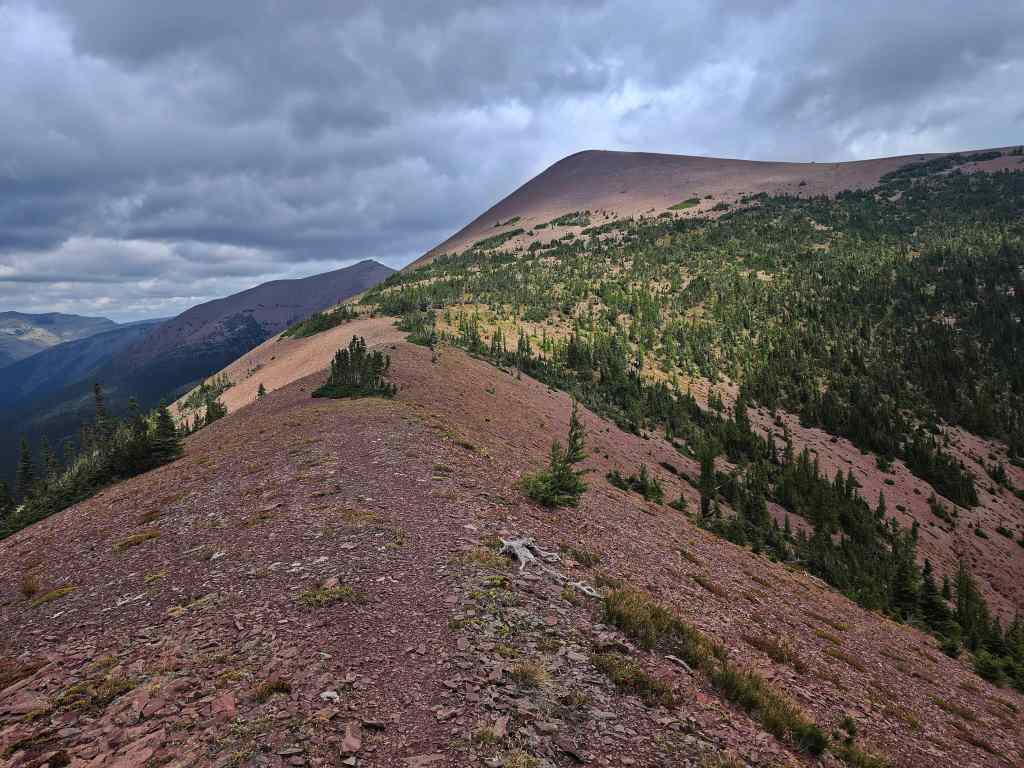
Making the easy ridgewalk to the summit of “Avion’s Brother” (left). The true summit of Avion Ridge is on the right.

Glancing over to Newman Peak (left) and “Newman Senior” (right).

This is why it’s better to not follow the trail on your way to Avion!

More of the same.

Still more of the same with “Newman Senior” on the left and Mount Glendowan in the distant centre.

Getting closer to the summit of “Avion’s Brother”.

A wider angle of the previous photo.

The summit of “Avion’s Brother”.

Looking to the east…

And now to the west.

The view back to Newman Peak (right) and Spionkop Ridge (centre).

Another look towards “Newman Senior” (left) and Mount Glendowan (centre).

Descending to the col with Avion Ridge.

A small tarn sits in the valley below.

I’m not sure there’s much water left…

Back on the trail.

An interesting, lichen-covered band of rock beneath the summit of Avion.

Glancing back to “Avion’s Brother”.

The valley between the two peaks is full of larches. To see how stunning this looks after the larches have turned yellow, read Andrew’s trip report from last October. 😀

More easy hiking.

The little valley is quite scenic.

Yet another look at the larches.

The view to the northwest and into Tatsiki-Miistáki (Castle).

More of the same.

Closing in on the summit.

Dark clouds overshadow Anderson Peak (left), Lost Mountain (centre) and “Kootenai Brown Peak” (right).

More ridge views.

I left the trail to follow the ridge more closely.

A giant crack that houses some giant marmots = a giant crack house…? 😂

I can finally see the summit.

Looking down at the tarn.

Only a few more metres to go…

The true summit of Avion Ridge (2420 m).

A pano to the east…

And then one to the south.

Finally, a pano to the west.

Mount Glendowan was a fun trip…

And so was “Cloudowan Peak”.

Mount Dungarvan and its rugged silhouette.

Speaking of rugged summits, Galwey North is in the centre and Mount Galwey is on the right.

Another look at Anderson Peak (left), Lost Mountain (centre) and “Kootenai Brown Peak” (right). There was definitely an ominous feel…

The summit of Piinaquiium / Ahkoinimahstakoo (Mount Blakiston).

The view over to Kishinena Peak (left) and beneath it, the Twin Lakes. Lost Lake is on the lower right and is where the trail from Avion leads.

A closer look at Lost Lake.

“Sage Senior” is also on my list. Edit: Done! 🙂

The trail continues along the ridge and towards Lost Lake.

Another one on my list: Font Mountain (centre)… Edit: Done!

Followed by Mount Matkin. Edit: Also done! 🙂

While I’m at, here’s another on my list: Sage Mountain. Edit: Done as well! 🙂

Castle Peak and Windsor Mountain (centre)

A long look to the north at Victoria Peak (right) and the South Peak of Pincher Ridge (centre) in front of it.


Gazing down the valley.

The summit of Spionkop Ridge.

Where I was earlier in the day, Newman Peak.

Looking over at “Avion’s Brother” (foreground) with “Newman Senior” behind it.

Looking back and along the ridge.

Almost an identical photo because film is cheap.

While I enjoy the sun, dark clouds continue to gather.

Another look at Kishinena Peak (centre) and the low ceiling above it.

A marmot (lower right of centre) lounges in front of Mount Glendowan.

Zooming in on my summit companion.

Heading back along the trail.

Another pano of the larch field.

In another few weeks, these larches will be golden.
At the col with “Avion’s Brother”.

A better look at the yellow lichen-covered band beneath the summit.

A group of backpackers descend towards me.

This fine group of people are from Edmonton and are heading to Lost Lake after spending the previous night at Goat Lake. We spent an enjoyable 20 minutes chatting with each other. Happy trails my friends! 🙂

Instead of regaining the elevation of “Avion’s Brother”, I followed the main trail.

Looking back at the summit of Avion Ridge.

Rounding the corner and heading to the Avion / Newman col.

A very cool mini cave.

Arriving back at the col.

From here it will be an easy ~1.6 km hike back to Goat Lake.

Following the trail down.

It seemed like the sun was always shining on the lake.

The view up to the col.

As I said before, if you like waterfalls, this is a good place to come.

Happy to finally be sheltered from the wind.

A forest throne for weary hikers. 😂

Getting closer…

The aptly named, fireweed, gives off a definite ‘Fall is coming’ vibe.
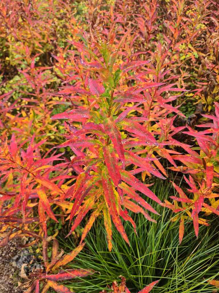
A closer look at some fireweed.

Oh deer!

Back at the lake and deciding to walk around it.

The first of many photos…

Newman Peak is on the far left and “Newman Senior” is in the centre.

I could see lots of cruising trout. 😀

Looking back to the col and Newman Peak (right).

One more lake photo…

Okay, I lied. This is the last one.

Heading down to the Snowshoe trail. Anderson Peak is in the centre.

Back on my bike and on the Snowshoe trail. Just prior to this, I spent another 20 minutes or so chatting with a young couple from Edmonton who were heading up to Goat Lake and then Lost Lake and then Twin Lakes for several days of peak bagging. Happy trails to them as well!

It would only take me 12 minutes to make the ~4.5 km ride back to the Red Rock parking lot. Weirdly, it would take me 25 minutes to simply leave the parking lot due to the insane amount of people and cars. However, outside of the young couple I just met, I saw no one else on the trail until I reached Red Rock Canyon.

A final look back to end the day. I always knew that Avion Ridge and Newman Peak would be a solo trip because they are among the easiest peaks to reach in Paahtómahksikimi (Waterton). For some reason however, I’ve left them to almost the bitter end because after today, I only have four official peaks left to do in the Park. My only regret about this trip was that I didn’t time it with larch season. A bright blue sky, golden larches, and red argillite would make this an eye popper for colour. If you want to see what I mean, then please read Andrew’s awesome trip report. 🙂


Leave a Reply