
⚠️ Hiking and scrambling are inherently dangerous activities. Please read my Disclaimer. ⚠️
I think Thrift Peak could be a great ridge walk. After all, it is easy to get to, fairly easy to ascend, and the 4.5 km hike along the ridge to the Livingstone Fire Lookout is full of interesting and readily negotiable terrain. The only real difficulty might be having to cross Na-to-ke-okos (Old Man River) a couple of times, but depending on the time of year and with some care, this is really not that hard. The reason I say, “could be a great ridge walk” is because Jeff and I completed the entire trip while in a cloud – literally. The views for our traverse along the entire ridge were limited at times to only a few metres and while we did not mind the constant drizzle, it would have been nice to have had some kind of view of the landscape beyond the immediate. Driving rain at the summit also forced us to abandon our plan to return the same way and instead, we descended the easy, but torturously long access road on the north end of the mountain. Once we lost elevation the rain stopped, but we were now faced with additional distance back to our vehicle. Anyone with foresight might have had bikes waiting or another vehicle, but we didn’t and so ended up have to walk back along the Forestry Trunk Road (Highway 40), which turned the day into a 24.4 km hike.

Our route started on the south end of Thrift Peak (right) in the Livingstone Gap. After studying several pictures of Thrift Peak that I had taken on a previous trip up Thunder Mountain, and looking at some topo maps, I figured that ascending the gradual slopes leading out of the Gap would not be difficult – and it wasn’t. I also surmised from the topo maps that there would only be a minimal elevation gain along the ridge from the southern end to the northern end. This, combined with the terrain, made for a fairly quick and easy trip along the ridge. The wrench in our plan to return the same way was the weather, however, if you had a second vehicle or had bikes, the loop we did would be fine and is one that could also be done in reverse. EDIT: In December 2013, I received a copy of Mike Potter’s Fire Lookout Hikes in the Canadian Rockies (2nd Edition). In it, Potter describes a similar route to ours and also gives information on the history of the old fire lookout on the south end.

The total distance for our trip was 24.4 km and the total elevation gains were 1085 m. The total time was just over 7.5 hours, but this would have been much shorter had we stuck to our original plan. It took us just over an hour to complete the entire ridge walk.

Crossing Na-to-ke-okos (the Old Man River) from our starting point in the Gap with our ascent slope in front of me. I brought along a pair of waders which made the crossing easier, but Jeff used only a pair of river shoes and this worked just as well. This was the first time that I’ve waded this section of Na-to-ke-okos without a fly rod in my hand. (Photo by Jeff Lang)

We chose to scramble up several small rock bands, but for the most part, these can be avoided by going either to the left or to the right. (Photo by Jeff Lang)

More fun terrain that can be avoided if desired.

Looking back down at the Gap once we gained some elevation. The ascent ridge for Thunder Mountain is in the background.

Looking east toward Camp Ridge (left). These would be some of the last views of the surrounding landscape that we would see all day.

Looking southwest along Racehorse Creek from the same vantage point.

Part way up the ascent slope, I happened to see something blue sticking out from underneath a rock. It turned out to be a fabric pocket that housed a geocache. We searched through the accompanying notepad, but no one else had written in it except for someone named Ray who had placed it there. I will keep what was in the geocache a secret. 🙂

The beginning of the ridge on Thrift Peak’s south end comes partially into view. The clouds were a sign of what was to come.

The clouds became thicker the higher we went and a constant drizzle emerged. The temperature however, remained pleasant.

The Livingstone Gap forestry helicopter base is visible for a few moments during a break in the clouds.

The cloud cover may have obscured most of our views, but it did allow the mood to be set for some interesting images.

Colourful lichen is juxtaposed against the blacked branch of a tree.

The last clear view of the day. The Forestry Trunk Road is visible far below.

As we neared the ridge we began to come across debris that had been left behind from an old fire lookout that had once stood on the south end of Thrift Peak. From this point until we reached the ridge, we consistently encountered old cables strewn about the landscape.

Shortly after finding the debris, we came across a fairly distinct trail which we would follow up to the ruins of the old lookout.

An old telephone / power pole points the way up. The top of the south ridge is barely visible through the clouds.

I head up a worn trail on the final section before the old lookout. (Photo by Jeff Lang)

The foundations of a structure at the old fire lookout. EDIT Jan 2014: Mike Potter in Fire Lookout Hikes in the Canadian Rockies (2nd Edition) notes that the original lookout in this location was built circa 1926 and was replaced by the current lookout location in 1956.

This was probably the location of the actual fire lookout. The area was littered with broken glass and discarded metal.

After a quick lunch, and with the majority of our climbing done for the day, we begin the 4.5 km ridge walk to the summit of Thrift Peak. (Photo by Jeff Lang)

Travel along the ridge was fairly easy as the terrain varied between sections of trees, sections of covered rock, and sections of minor scrambling. Any bushwhacking was minimal as numerous animal trails provided clear paths through the vegetation.

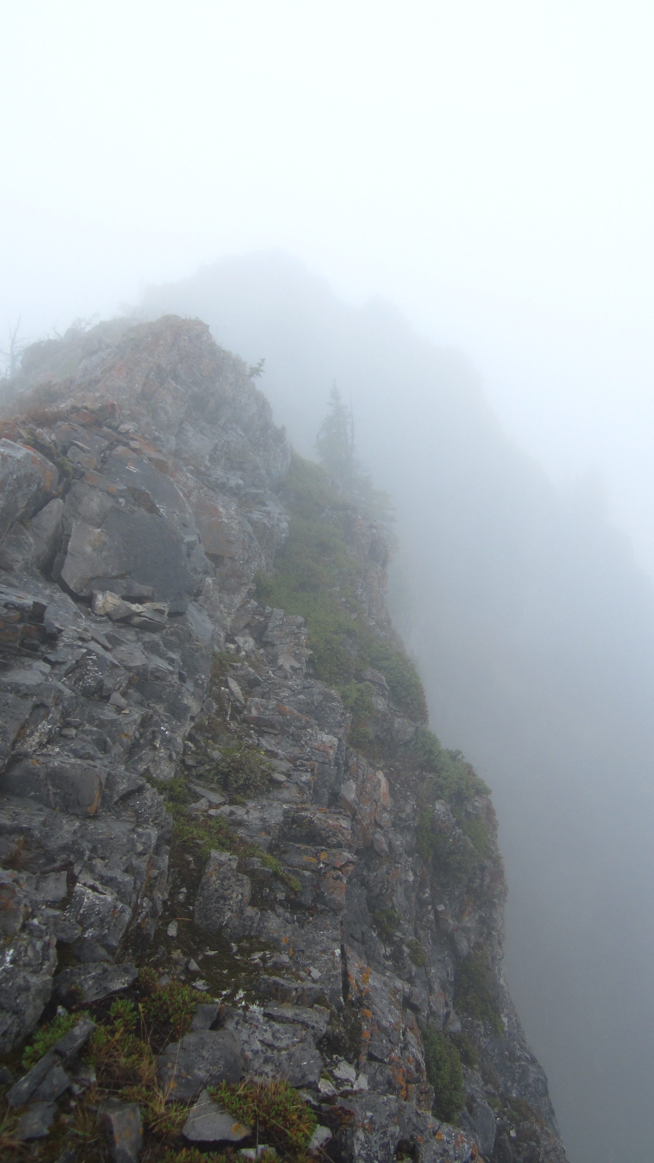
Further to the north, the ridge narrows in sections but any exposure can be avoided for the most part by staying to the left.

Since we couldn’t see anything else, here is another shot of the fun terrain along the ridge.

Like a gorilla in the mist…

More typical terrain along the ridge. As I said, this ‘could’ be a great ridge walk if it were done under clear skies. Nevertheless, it was still fun and required minimal gains in elevation between the south end and the north end.

Jeff peers over the edge into a misty abyss.

Just over an hour after leaving the south end of Thrift Peak, the Livingstone Fire Lookout comes into view – well sort of. At this point, the constant drizzle had turned into fairly heavy rain.

From this angle, the Livingstone Fire Lookout looks like the fortress of an evil villain from a Bond movie. We were really hoping that an attendant would still be on duty and would welcome us with a hot cup of coffee 😉 Unfortunately, it had been locked down for the season and our hopes were shattered.

Jeff stands in front of the Livingstone Fire Lookout on the summit of Thrift Peak. The lookout actually sits on the edge of a large cliff face, but it was impossible to see anything beyond a few metres. EDIT: An interesting note from Mike Potter in Fire Lookout Hikes in the Canadian Rockies (2nd Edition), is that the “heaviest snowfall to hit Alberta in one day – 44 inches – was recorded (…) at the Livingstone Fire Lookout Tower. And it did not fall in winter; it fell on June 29, 1963.” (p.32) Potter also notes that this was the Canadian record for the most snow to fall within a 24 hour period until 1974.

I think this picture of me is descriptive as to how wet it actually was. It was at this point that we decided to change our plans and not return the way we had come as the rainfall had become more intense, and walking back along the ridge, easy as it was, was not so appealing in heavy rain. We decided to try and make a quick descent using the access road to the Lookout. EDIT: According to Mike Potter, the helipad that I’m standing on is the location of the original structure from when it was relocated from the south end in 1956 until 1975.

After quickly snapping a couple of pictures in front of the Lookout, we headed down the access road. Here is where our trip became longer than we had hoped. The access road is very easy to hike and the grade is minimal, but it is LONG, perhaps as much as 10km long. Fortunately, the rain lessened the lower we went in elevation.

The access road was actually quite pretty.

At the bottom of Thrift Peak, the access road parallels the Old Man River southwards for a couple of kilometres before crossing. We found that since the historic spring floods, the river had changed course in several places and the original crossing point for the road was no longer feasible. We ended up following the river for several hundred metres downstream to a new location.

Jeff wades across Na-to-ke-okos (the Old Man River) on our return. We ended up crossing where Dutch Creek enters the river. Only the lower section of Thrift Peak is visible in the background.

Looking toward the Livingstone Gap as we made our way back along the Forestry Trunk Road. Our ascent slope is on the left and Thunder Mountain is on the right. Despite the rain, limited views, and an inordinate amount of unplanned hiking, this was still a very fun day.