
⚠️ Hiking and scrambling are inherently dangerous activities. Please read my Disclaimer. ⚠️
One of the great things about winter in southwestern Alberta, is the chance to explore the outliers that you would normally ignore or bypass in the summer. As I’ve stated numerous times before, many of these unnamed objectives offer great views and when tackled under winter conditions, end up taking as much energy to summit as a bigger peak would in the summer.
So, with another windy chinook weekend upon us, Brad and I headed to Tatsiki-Mistáki (Castle) to try our hand at one of three interesting outliers in the north Drywood Mountain area. Hoping for shelter from the wind and something new to explore, we set our sights on the most prominent of the three, a decent-sized bluff that towers above North Drywood Falls. Though impressive from the trail, this bluff is really the end of the very long and gradual north ridge that leads off the Southwest Summit of Drywood; hence the nickname, “North Drywood Ridge”.
Likewise, the nearby second objective that we were also considering, marks the end of a small branch off of the same north ridge. In fact, we initially thought that “North Drywood Ridge” was the smaller of the two; however, we soon realized that the actual summit was not visible from the trail but was located ~750 m or so from the top of the bluff. Once on the 2138 m summit, we found ourselves looking down at the second objective – something that surprised us. We also realized that any thought of tagging both was not realistic due to distance and deep snow; though in hindsight, it would have been possible to keep going along the ridge and then hike back to the second objective via the short connecting ridge. This may be the desired loop but it would still be long.
All in all, this ended up being a great winter objective that included a little bit of everything. Not only were we sheltered from the wind for most of the day but we also enjoyed a variety of terrain. In fact, we ended up making six gear swaps throughout the day – from snowshoes and poles in the trees, to crampons and ice axes to ascend and descend a couloir – we used everything that we brought. The crux ended up being the waist- and knee-deep snow that we encountered shortly after crossing North Drywood Creek and then again shortly before arriving at the bluff beneath the ridge. Indeed, this short ~180 m stretch of steep terrain, deep snow, and heavy bushwhacking was soul-sucking. It was also not fun to descend, but thankfully it was short-lived. In fact, though it took us 4 hours in total to reach the summit, it only took 2 hours to return as we took advantage of all the trailblazing work we had put in earlier. Moreover, as the ridge was was surprisingly sheltered, we were even able to enjoy a prolonged lunch break shortly after leaving the summit. 😀
Both Brad and I decided that we will definitely return to try for the second objective and are holding the even smaller, third objective (which I call ‘The Twig’) in reserve for a day of more inclement weather. As always, spending time on a mountain with Brad makes for a great day – and even more so when he takes the lead in blazing a path through deep snow! 😂 Thanks Brad!

To get to “North Drywood Ridge” we drove south from Pincher Creek on Highway 6 until we reached the Shell Waterton Complex Road (Township Rd. 43A). We then turned onto the road and drove west for ~9.1 km until we came to a junction with a gravel road near to the entrance of the plant. Here, we turned left and onto the gravel road where we continued for ~3.9 km until we reached Butcher Lake. We then turned left and onto another gravel road immediately prior to the Lake, following this road for ~1.4 km until we came to a junction where we could either turn left or keep going straight. We kept going straight for another ~610 m and arrived at a locked gate and a parking area. This is the trailhead for North Drywood Falls and our starting point.
From the trailhead, we hiked ~3.2 km along the trail until we were across from an obvious drainage immediately to the north of “North Drywood Ridge”. Here, we left the trail and crossed North Drywood Creek as we made our way towards the drainage. After arriving at the drainage, we stayed in it for only a short time, opting to leave it when we could see it forming into a canyon.
After leaving the drainage, we continued southwards and upwards through the trees for ~500 m or so until we arrived at the base of the bluff beneath the summit ridge. While travel in the trees consisted mostly of light bushwhacking, the final ~180 m stretch before the cliffs was a gnarly combination of deep snow, heavy brush, and steep terrain.
Though avoidable, we opted to climb a short snow-filled couloir from the base of the cliff to reach the upper slopes of the summit ridge. Once on the ridge, it was another ~750 m or so of snowshoeing to reach the summit. We returned the way we came.

Our total roundtrip time was 6 hours and 20 minutes and our total distance travelled was 13 km. Total elevation gains came in at 821 m. I’m not sure why I’m even including this graph as the chinook weather messed with my barometric altimeter something fierce; producing this monstrosity and I honestly have no desire to fix it. 🤪

Gearing up at the North Drywood Falls trailhead.

Our third objective (centre) – that I’ve nicknamed ‘The Twig’ – which we considered, but will save for a really bad weather day.

We could see “North Drywood Ridge” (right of centre) shortly after starting.

Gazing across to the gully that Andrew and I used to reach “The Stirrup” (right of centre) on Pincher Ridge.

“North Drywood Ridge” (centre) and a second unnamed peak (left) from the trail. Both objectives mark the end of the long north ridge of the Southwest Summit of Drywood and are probably not something you’d invest time into during the summer months – unless of course, you were heading to the Southwest Summit, then this might be a neat route. 🤔 However, in the winter they are appealing objectives, particularly if you’re looking for shelter from the wind.

Looking over to a popular ice-climbing spot on Drywood Mountain.

Approximately 3.2 km from the trailhead, we came to a spot where we could see a drainage cutting through the trees on the north side of the ridge. This is where we decided to leave the trail as access to the creek and the drainage looked to be straightforward.

Heading down to North Drywood Creek.

Crossing the creek was easy…

However, ascending into the trees on the other side proved to be difficult due to deep snow.

With Pincher Ridge in the background, we attempt to bypass the initial section of deep snow by heading to climber’s left…

However, there was no escaping it. It was a long, slow process, but eventually we reached the trees.

In the trees and heading towards the drainage.

Brad stops to admire Pincher Ridge from alongside the drainage. “North Drywood Ridge” is in the background on the right.

Inside the drainage.

A closer look at a small waterfall.

Looking back as Brad enters the drainage.

We could hear running water beneath the snow.

Brad climbs through a narrow section. Beyond this point, we could see that the drainage turned into a steep canyon, so we decided to leave it.

Heading through the trees. At first, the snow was fairly shallow…

But it grew deeper the higher we went.

Most of the lower and middle sections involved light bushwhacking.

Brad enjoys his pipe as we angle our way up and through the trees.

The upper section of forest proved to be much more difficult. Deep snow, heavy brush, and steep terrain made the final ~180 m a soul-sucking affair. It was even frustrating to descend on the way back.

Finally arriving at the base of the ridge.

At the time, we thought that the summit was located close to the top of this bluff – but boy, were we wrong! 😂 It turned out that what we thought was the summit from the trail, was merely the lower section of a ~750 m+ ridge walk.

Looking at our possible second objective as we head up and towards the bluff. If the summit of “North Drywood Ridge” had not been so far away, we may have tried for the second one. However, we now have a reason to return. 😀

Looking back at the point where we emerged from the trees and then along the valley back to the trailhead.

Though we could avoid the bluff by keeping to climber’s left, we decided to look for a more direct route to the top.

Voila! 😁 A beautiful snow couloir that we could use for both ascent and descent.

I lead the way… (Photo by Brad Wolcott)

Followed by Brad.

Another look back to Brad, this time with the summit (right of centre) of Drywood Mountain in the background.

Traversing the slopes above the couloir.

Arriving on the ridge above the bluff with the summit of Pincher Ridge in the background.

The section immediately above the cliffs.

Again, we were thinking that from here, the summit wasn’t too far away.

I lead the way, though will soon swap my crampons for snowshoes. (Photo by Brad Wolcott)

The lower section of the ridge provides some great views of Pincher Ridge. You can also see the North Drywood Falls trail far below.

The ridge also gives you a great view of Pincher Ridge’s Centre Peak.

Closing in on what we thought was the summit from the trail…

However, the ridge just kept going up.

It was amazing how sheltered from the wind we were. It was ripping all around us, but it remained calm along the ridge.

Another look at Pincher’s Centre Peak.

Continuing up…

And up. Thankfully, it was a beautiful snowshoe.

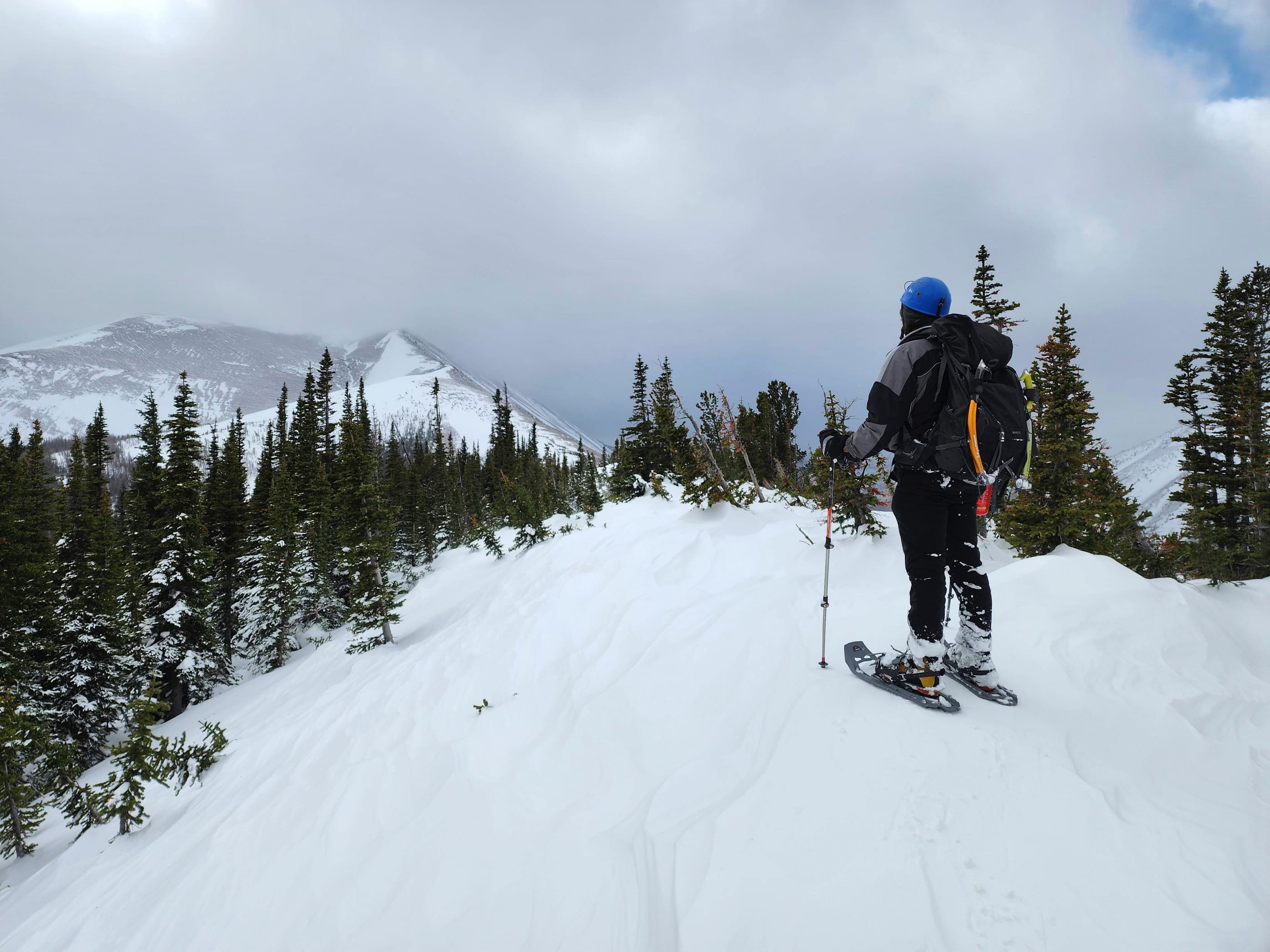
Finally, the ridge begins to open.

The summit is still a ways off from here.

Brad checks out the view toward the Southwest Summit of Drywood.

Continuing towards the summit.

All three peaks on Drywood Mountain.

Gazing back along the ridge.

Bypassing some snow. The South Peak of Pincher Ridge is on the right with a beclouded Victoria Ridge in the centre.

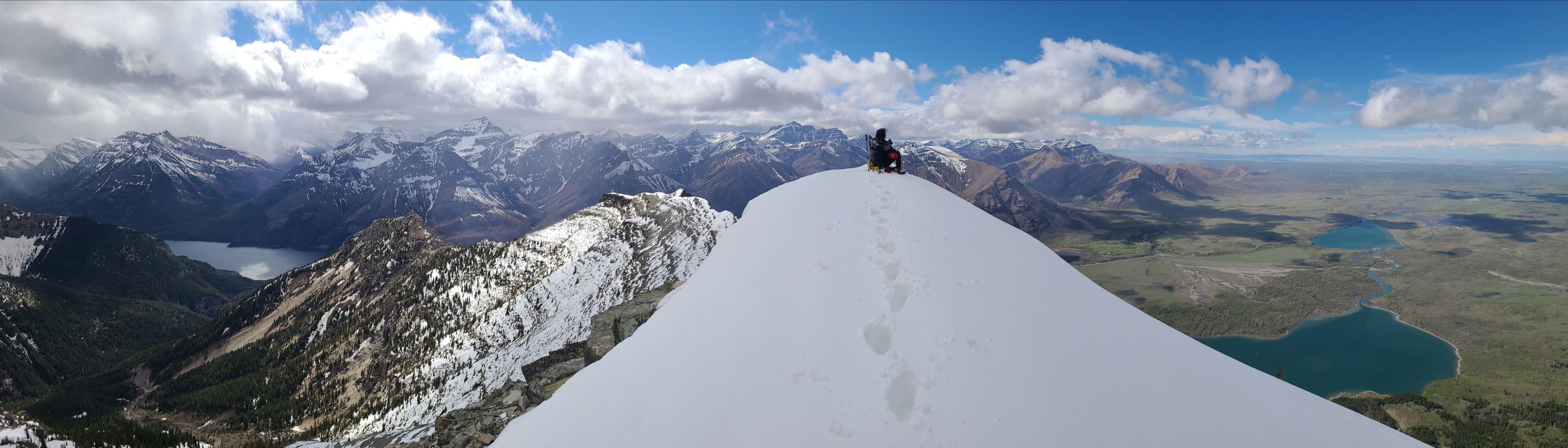
The summit of “North Drywood Ridge (2138 m).

Another look across to all three peaks on Drywood: Drywood Mountain (far left), “Redwood” (centre), and the Southwest Summit (far right).

A closer look at Pincher’s South Peak…

Then its Centre Peak…

And finally, Pincher Ridge itself. If you ever get a chance to traverse the entirety of Pincher Ridge, do it. It is one of the most colourful mountains in the area.

A closer look at the summit of Drywood Mountain.

The bump in the foreground is the second objective that we could see from the trail. However, it is a long way off from here, so we’ll have to make a return trip. The middle peak on Drywood – “Redwood” – is in the background.

Finally, gazing along the ridge towards the Southwest Summit of Drywood.

Brad on the summit…

And then me. 😂

Heading back…

But not before a leisurely 20 minute lunch break.

Enjoying the views from the lower section of the ridge.

Almost at the end of the ridge.

After yet another gear swap, we descend towards the couloir.

Brad enters the couloir…

And skillfully makes his way down.

Looking up from the bottom.

One last section to descend…

Before arriving back at the trees where we’ll swap our crampons for snowshoes.

After slowly navigating our way through the steep upper section, we made quick work of what remained.

Nearing the drainage…

And now in the drainage.

Almost back at the creek.

On the road and looking back at “North Drywood Ridge”.

It was an easy ~3.2 km walk from here.

One more look at “North Drywood Ridge” and the second objective to its left.

Arriving back at the trailhead 6 hours and 20 minutes after starting. “North Drywood Ridge” was a great choice for today as it not only sheltered us from the wind, but gave us the chance to explore new terrain on the front range of Tatsiki-Mistáki (Castle). We will definitely be back for both “The Twig” and the yet-to-be-nicknamed second objective. Thanks again to Brad for another fun day in the mountains! 😀


Leave a Reply