
⚠️ Hiking and scrambling are inherently dangerous activities. Please read my Disclaimer. ⚠️
Now that I’m in my fifties, I find myself repeating things – and mountains are no exception. I was last on the summit of Victoria Peak in 2013, but when Andrew suggested we try a route that he had scoped out back in February from “Whitney Ridge”, Brad and I were all in. This route, which ascends a spur located northwest of the summit, was attempted by Andrew in April, but deep snow at the first of two gendarmes along the connecting ridge forced him to turn back. He did however, confirm what sheep hunters and many longtime scramblers in the area probably already knew, that once you are on the northwest slopes of Victoria, there are clear routes to the top. This was further validated in June by Calgary-based scrambler, Robb Schnell, who emailed Andrew to say that he had completed the route and found that it was only a moderate scramble to reach the top. This was great news, and solidified our resolve to complete it as well. Thanks Robb!
Now that I’m in my fifties, I find myself repeating things – and mountains are no exception… wait, have I already said that? 😉 Seriously though, this route is a great alternative to the popular track laid out by Andrew in, More Scrambles in the Canadian Rockies, offering more opportunities for scrambling and route finding, and some pretty cool views of Windsor Mountain and Castle Peak. However, equally intriguing (at least for me) was our descent route along the long ridge that I’ve affectionately nicknamed, “Whitney Ridge”, after nearby Whitney Creek.
I’ve often thought that a trip to the highest of its three distinct points – the first two being, “Whitney Creek Mountain”, and Whitney Ridge” – would be an interesting ridge walk that could also lead directly to the summit of Victoria Peak. This high point, that I banally refer to as, “Whitney Peak”, is the corner point of the ridge and is distinct enough from Victoria – at least by my eyes – to be considered an objective. Regardless of whether gatekeepers or mountain purists agree with my designation, the route back along the ridge was an amazing exercise in scrambling. Indeed, it took us longer to descend because of all the down-climbing and narrow ridge walking, than it did to ascend using the spur. Afterwards, all three of us agreed that the entire loop might best be done in reverse, but either way, we certainly did not lack for excitement throughout the day.
Be sure to read Andrew’s fantastic trip report! Also, check out his recon solo trip from April.

To get to the northwest route up Victoria Peak from Lethbridge, follow Highway 507 west of Pincher Creek to the Gladstone Valley Road which is located on the left side of the highway, ~1.4 km past the bridge over Mill Creek. After turning onto the road, keep left at all major junctions, and you will eventually cross two bridges over Mill Creek. Approximately 16.3 km from Hwy 507 or ~3.5 km from the 2nd bridge, you will come to a hairpin curve that also serves as a junction for a gated gas road. This is the starting point.

Follow the gas road (an easy hike but definitely better if you bring a bike) from the gate for ~3.65 km until you come to the second bridge (the first is at the ~2.8 km mark). To ascend using the northwest spur, cross the bridge and enter the forest alongside the creek immediately on the other side. If you want to ascend via the “Whitney Peak” route, don’t cross the bridge, but look for a distinct trail that enters the forest (it’s close to the slope on your right and not next to the creek) and follow it as long as possible, as you head up the valley towards obvious slopes that lead onto the ridge. Be warned that there will be some bushwhacking unless you want to ascend “Whitney Ridge” first.
For the northwest spur, we followed Andrew’s previous track by following the creek for ~60 m before beginning to angle up and onto the ascent slope. After about 10 minutes of tedious bushwhacking, travel amongst the trees became easier and we had no problem reaching the top of the ridge after another ~625 m of hiking combined with an elevation gain of ~180 m. Once on the ridge, the route to the spur is obvious and we enjoyed the ~1 km walk to reach the base of the spur. This is where the scrambling starts.
From the base to the top of the spur, it was ~410 m (distance) of enjoyable route finding and scrambling. Once on the connecting ridge, we stuck to the crest for another ~395 m before coming to the first gendarme that forced a bypass to climber’s right. Once back on the ridge, it was not long before the second gendarme forced us back down even further, before eventually making our way back. From the ridge beyond the second gendarme, it was another ~220 m until we reached the proper northwest slope of Victoria Peak. There appears to be several routes up from this point, with the first being a broad gully that leads up towards the summit. This is the route Brad and Andrew used, while I headed a little further to west and utilized another gully. From my vantage, I could see other potential routes as well. For me, once I was on the northwest slope, it was ~280 m of scrambling to reach the gentle ridge beneath the summit. In total, from the creek to the summit, it was ~5.4 km with an elevation gain of ~965 m.
Descending via “Whitney Peak” was easy for the first ~1.5 km (~315 m in elevation) as we followed a scree slope down the connecting ridge. However, after that, it became a series of steps along a narrow ridge for the next ~1.3 km to reach the summit of “Whitney Peak” and the start of “Whitney Ridge”. The ~730 m trip to its lower, twin summit was even more exciting with the ridge narrowing in places to as little as 30 to 40 centimetres, though thankfully, this was easily bypassed. From the twin summit, it required another ~1 km of scrambling and down-climbing to reach the col with “Whitney Ridge”, before we could drop into the valley and follow the creek for ~2.2 km back to the bridge and our bikes.

Our total roundtrip time was 8 hours and 24 minutes with total elevation gains of 1331 m. Our total distance travelled was just over 20 km. Our ascent time for Victoria Peak ended up at 4 hours and 2 minutes, whereas our descent time using “Whitney Peak” was 4 hours and 22 minutes.

Gearing up on a gorgeous Friday morning. This was also the starting point for our February 2020 snowshoe trip up “Whitney Ridge”.

Andrew laughs as he speeds past me on his new toy – an e-bike. While Brad and I actually had to use human power, Andrew effortlessly conquered the ~144 m elevation gain demanded by the gas road. I’d like to think that Brad and I bettered ourselves through the extra effort that we had to put into this trip. 😉

Our route up Victoria soon comes into view.

While Brad and I had to push our bikes up a hill, Andrew effortlessly zoomed on, leaving plenty of time for him to study the route and relive old memories. The spur and connecting ridge are in the centre of the picture and behind it, is our descent route.

Arriving at the second bridge ~3.65 km after starting. We would stash our bikes in the trees immediately on the other side, and begin following the creek for ~60 m before ascending the ridge on the right. On our return, we would follow the trail that emerges from the trees on this side (pictured) of the bridge.

Andrew desperately looks for an e-bike charging station. 😂

Finally forced to use his legs, an atrophied Andrew leads the way.

We only experienced ~10 minutes of unpleasant bushwhacking after leaving the creek and starting up the slope. This is what the remainder of travel looked like within the trees.

Breaking out onto the top of the ridge after another ~625 m of hiking and an elevation gain of ~180 m.

The view over to last February’s snowshoe destination, “Whitney Ridge”, where Andrew had initially pondered this route up Victoria.

Looking back along the gas road to another great snowshoe destination, “Whitney Creek Mountain” (right).

A pano from along the ridge. Did I already mention that it was a gorgeous day?

A telephoto of the iconic Castle Peak.

To the west sits the colourful trio of “Mill Creek Mountain” (left), “Mill Creek Peak” (centre), and Mount Gladstone (right).

Making the ~ 1 km trip along the ridge to the base of the spur.

It was awesome to be immersed in so many colourful blooms.

Getting closer and enjoying an even better look at the route.

We would follow Andrew’s track from April and ascend to almost the top of the point on the right, before skirting climber’s right to avoid an impassable wall.

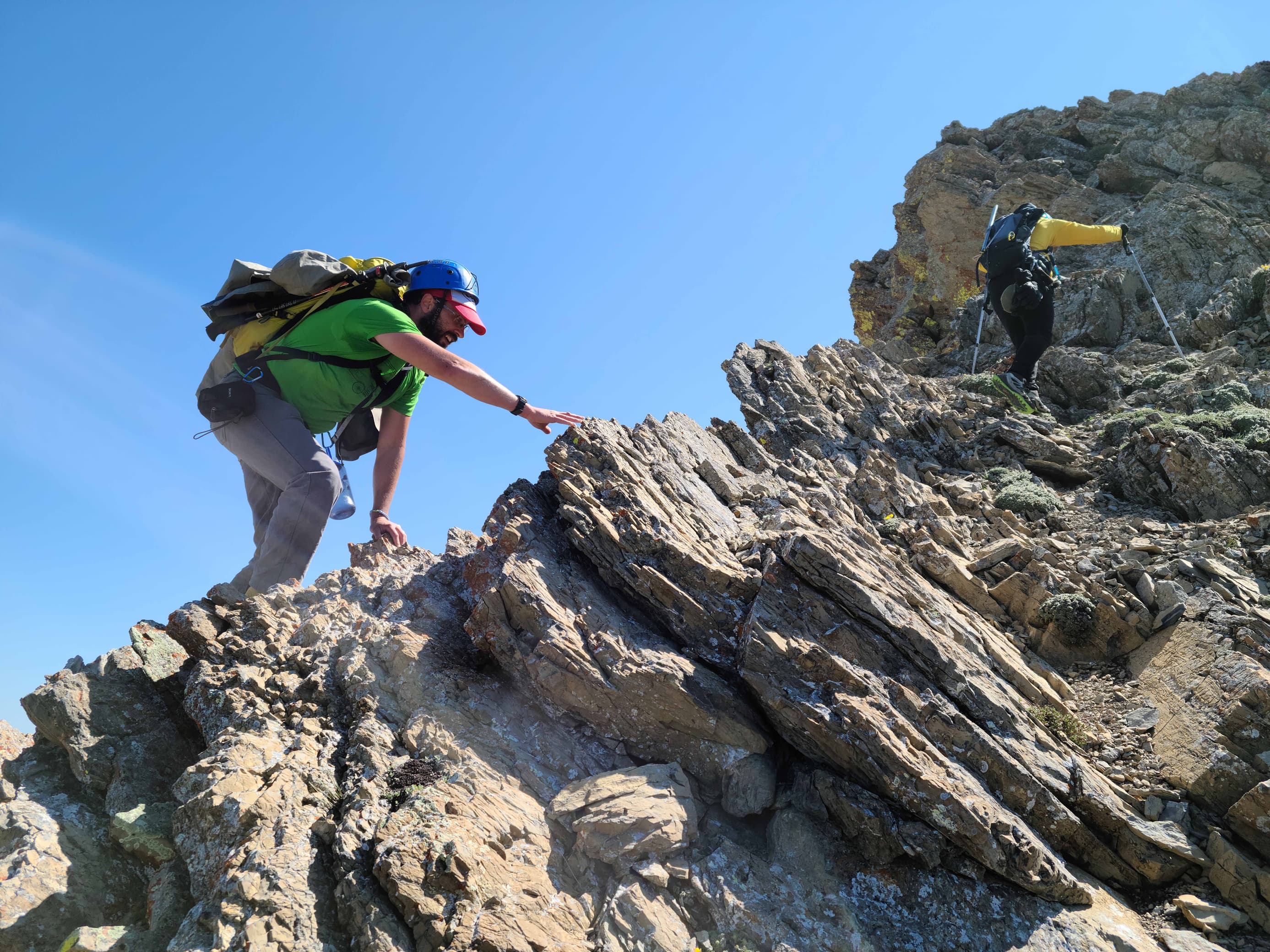
Getting into the fun stuff!

Brad and I pause to check out possible routes up the northwest slope of Victoria. (Photo by Andrew Nugara)

Continuing up to the point on the right.

Brad leads the way.

Andrew checks out the route to the top while wishing he could simply use his e-bike. 😉 It was also possible to bypass this whole thing by just keeping to climber’s right and working your way around to the other side – but why?

Andrew’s turn to lead again.

Followed by me. (Photo by Brad Wolcott)

A wider view from Brad’s vantage. The top of the point reminded me of a crown because of its jagged overhangs. Fitting perhaps given the mountain’s imperial name. (Photo by Brad Wolcott)

The view back to Brad and our entire route up to this point.

Andrew skirts climber’s right beneath the crown.

A closer look at the crown. Okay, okay. I didn’t say it was a pretty crown!

Looking down from atop the crown, as Brad begins to skilfully climb what Andrew and I chose to avoid.

Andrew’s perspective of the previous picture. You can just see my head poking up on the top left. (Photo by Andrew Nugara)

The highest point on the spur is impressive!

Brad climbs the remaining section of the crown using a more sane route. In the background are Windsor Mountain and Castle Peak.

Carefully peering over the edge of the crown.

Making our way over to the highest point of the spur. Again, you could bypass all of this for the joys of a rubble slope – if that’s what floats your boat.

Quelle surprise! Andrew is checking out some red argillite. 😊

Brad’s vantage of the previous picture. (Photo by Brad Wolcott)

Glancing back at the first high point a.k.a. the crown.

The rock was great for scrambling.

Drawing close to the high point of the spur.

I think this route is a great alternative for those who like to get as much scrambling in as they can.

Andrew and Brad arrive at the top of the spur.

From the top, we could see along the connecting ridge all the way to the summit.

The view down the spur’s impressive face.

Gazing back to the crown and thinking that Olivia Coleman is just as good as Claire Foy. 😉

Spurring myself on. 😉 (Photo by Andrew Nugara)

Alpine buttercup (the flower that is and not Brad) 😂.

Casting another glance back to the high point of the spur.

To quote Dougal McGuire from Father Ted, “Careful now!”

With Prairie Bluff in the background, Andrew contemplates how he could ride his e-bike to the summit for his 100th visit. 😂

Approximately 395 m from the spur, we came to the first gendarme. This is where Andrew was forced to turn back in April due to deep snow.

Only goats would dare venture onto these ledges – though they did remind Andrew and I of our Triple Divide trip last summer.

To get around the gendarme, we dropped to climber’s right.

More impressive rock.

Andrew uses a weakness to avoid losing more elevation.

From the weakness, we scrambled up a small chimney to the regain the ridge.

Following Andrew up the chimney. (Photo by Andrew Nugara)

Back on the connecting ridge and approaching the second gendarme.

Brad shows off a rusted metal artifact left by a previous party of scramblers, sheep hunters, or roving band of scrap metal salesmen.

Moss campion and alpine buttercup.

Just like the previous obstacle, there was no where to go but down to climber’s right.

This ended up being a longer bypass than the first.

Andrew checks out a small cave from which a glimmer of light can be seen near the back. Could this be the fabled e-bike charging station? 😂

Disappointed, Andrew continues his search for the charging station.

A very cool layering of rock.

This is where I decided to scramble up to the ridge. (Photo by Andrew Nugara)

Andrew and Brad also chose different paths back to the crest.

Back on the ridge and getting closer to the northwest slope of Victoria. (Photo by Andrew Nugara)

The view back along our entire route thus far.

Enjoying a few moments of flattened terrain.

We eventually came to this section of red argillite cliffs at the end of the ridge. While the route goes to climber’s right, we couldn’t help but to explore the section to climber’s left.

The cliffs are marked by colourful overhangs.

Yellow lichen on red argillite is a Castle staple.

A possible route for the brave at heart.

The overhangs continue for quite a while.

It looked entirely possible from this point to be able to keep going onto the north slope of Victoria from which, there are probably other ways to the top. One day, we’ll have to come back again and try it out.

Heading back along the cliffs to the connecting ridge.

Back on the ridge once again.

Heading over a series of argillite steps. (Photo by Andrew Nugara)

Brad follows close behind… Keep the 2 m physical distance buddy!

Looking up after reaching the northwest slope of Victoria Peak.

Hanging out under a small arch… (Photo by Andrew Nugara)

And now making the short scramble over the arch.

Gazing up the gully that Robb Schnell described to Andrew.

As there appeared to be a number of options, the three of us began to separate and explore.

A better look up the main gully that emerges just beneath the summit.

This rich green moss offered a neat splash of colour.

Andrew and Brad continue to explore different routes.

I ventured further to the southwest from the main gully and started up this smaller, neighbouring gully.

Andrew is quite far away now.

Andrew’s view back to me. (Photo by Andrew Nugara)

I ended up ascending the smaller gully on the lower left.

Brad (right) keeps working his way up the main gully.

At the entrance to the small gully.

Meanwhile, Brad continues to work his way up the main gully. (Photo by Andrew Nugara)

Once in the gully, I could keep to climber’s left and ascend parallel to the main gully, or head to the right and up an even narrower gully to the summit ridge. I chose the latter..

But first I followed it to left where I could see that Brad and Andrew had reconnected.

It was a quick scramble to the top from here.

Gazing back along the small gully that I used. There appeared to be many others like this that could be used for ascent.

On the main ridge…

With the summit only a short walk away.

Brad nears the top of the main gully, but where’s Andrew?

Brad’s now on the ridge, but still no Andrew. He must still be searching for that e-bike charging station.

My second time on the summit of Victoria Peak (2587 m). The first was a great trip with Jeff in 2013.

A pano to the west.

A pano to the north.

A pano to the east.

And a pano to the south.

Ah, there’s Andrew in the distance. His poor legs had become so atrophied from using the e-bike, that he barely had enough strength left to complete the scramble. 😂

Windsor Mountain and Castle Peak.

The view across to North Castle (centre) and Mount Gladstone (left).

Gazing northwest at Mount Gladstone (left) , “Table Top” (centre), and Table Mountain (right).

Another view to the northwest with our ascent route up the spur in the foreground with, “Whitney Ridge” (centre) and “Whitney Creek Mountain” (right) behind it. In the distant centre is “Gladstone’s Toe”.

No matter the time of year, Prairie Bluff and its outliers are always fun.

Looking to the southeast at Pincher Ridge (foreground) and Drywood Mountain.

Another view, this time further to the southeast at the Centre Peak of Pincher Ridge (foreground), the Southwest Summit of Drywood (right), and behind it, Loaf Mountain.

Gazing south at Victoria Ridge (right of centre) and the South Peak of Pincher Ridge (left).

Looking southwest at Kenow Mountain (left) and Langemarck Mountain (right). That whole ridge looks like it would be an interesting trip.

Two of my favourite humans!

No matter the mountain and no matter how many times up, it’s always a privilege to go hiking.

I like this canister.

Looking down at our ascent route (centre) and part of our descent route with “Whitney Peak” on the left and “Whitney Ridge” on the right. This turned out to be an amazing, but long descent.

Leaving the summit to explore a new route back. Click to continue to “Whitney Peak”.


Leave a Reply