
⚠️ Hiking and scrambling are inherently dangerous activities. Please read my Disclaimer. ⚠️
As news of the Canadian Expeditionary Force (CEF) reached home, it provided A.O Wheeler and the Alberta / B.C. Boundary Survey a convenient source of mountain names that in turn, furthered a patriotic narrative fostered by a federal government desperate to recruit more men for the trenches in Europe. Such is the case with Hollebeke Mountain, which was named in 1917 after a Belgian village located within one of the bloodiest sectors of the First World War, the Ypres Salient.
It is hard to find a record stating who exactly named Hollebeke, but it is logical to assume it was Wheeler who, “named over 100 geographical features related to World War I” along the Great Divide. (Jay Sherwood, Surveying the Great Divide: The Alberta/BC Boundary Survey 1913-1917, 162) That 1917 also marked the fiftieth anniversary of Confederation, it makes sense that a name related to the First World War would be chosen, particularly under the shadow of the ongoing conscription debate. I am unsure however, as to which CEF engagement it is referring to, but depending on when in 1917 the name was bestowed, it could be in reference to the Third Battle of Ypres and in particular, the Second Battle of Passchendaele where, between October and November 1917, Canadian forces captured Passchendaele Ridge at a terrible loss, with 15,654 casualties. (Canadian War Museum)
Today’s trip extends back to 2014 when Bob Spirko, Jeff Lang, and I made a trip up neighbouring Mount McCarty and noted that Hollebeke looked to be an interesting ascent. Shortly after posting that trip report, Gord Blair emailed me to say that he and legendary Lethbridge-based scrambler, James Yearous, along with other members of the Southern Alberta Alpine Club, had ascended Hollebeke from MacDonald Pass. I thought this looked like an interesting route, but I also noted on a map, that there was a trail that led directly from the North Kootenay Pass trail onto the eastern col beneath the summit. I filed these routes together in my mind as a potential loop, but like many mountains for me, time and destination distraction became the limiting factors.
Recently, I was excited to see that Matthew Clay and Sonny Bou had ascended Hollebeke using the MacDonald Pass route. This brought the mountain back to the forefront of my mind and when Andrew suggested it for today’s trip, I was more than ready to tag along. As Andrew wanted to revisit North Kootenay Pass (NKP) to gather more information for his upcoming book, and because neither Brad or I had been there, we decided to ascend Hollebeke from NKP. Knowing that Rick Collier had used this route in 2006, and then in 2018, All Stone Adventures documented a similar ascent, we followed their lead – with the addition of tagging the high point immediately above the Pass as opposed to side-sloping it to the col beneath the false summit.
Moreover, as Andrew had also noted the trail beneath the summit, we decided to make the trip into a loop and after traversing a large portion of the ridge in addition to the summit, we descended a clear trail from the col into the northeastern bowl. From there, we followed a great (well, for the first ~2 km or so) ATV/snowmobile/logging trail back to our bikes and the NKP trail. Given its condition, I’m positive this trail is well-known to sheep hunters.
Now that my interest in the NKP area has been rejuvenated, I think I will try and make another trip as soon as I can, as there are other intriguing peaks in the area that have long been on my radar. If peak bagging is not your thing, but you want to explore a unique area of the Castle, it is a worthwhile trip in and of itself to make NKP your primary destination, though I would recommend using bikes for as much of it as possible.
Finally, one of the unique highlights of the day was meeting Vern Dewit and his daughter on the trail shortly after starting. They were heading to Mount McCarty (be sure to read his trip report) and though I’d chatted with him many times over the years, we’d never met in person, so this was one of those very cool happenings in life – even though we didn’t recognize each other at first. 😂
Be sure to read Andrew’s trip report!

To get to Hollebeke Mountain, drive south from the hamlet of Beaver Mines along Highway 774 for ~15.5 km until you come to the Lynx Creek (Ohagen Road) turnoff on your right (just past the Beaver Mines Lake turnoff). Turn and follow the Ohagen Road for ~1.8 km until you come to a fork and a sign that says to turn left to reach Lynx Creek. Like a good Canadian, obey the sign and turn left as going straight is now restricted access. Keep going for ~7.7 km until you come to a T-intersection. Turn left and follow the Carbondale River Road for ~2.6 km until the road forks to the right (Lost Creek Road). There is an information sign and a large area to camp just beyond this junction. This is where we parked because Andrew thought only my 4Runner could make the remaining ~4 km over an increasingly rough road to the trailhead. If you have a sturdy vehicle, keep going to the actual trailhead. I will recommend bringing bikes regardless of where you start.

From the trailhead, it is ~3.0 km to reach the fork to MacDonald Pass. You will cross four recently constructed bridges in the process. Unless you want to ascend Hollebeke from MacDonald Pass, keep going straight along the NKP trail. At the ~3.4 km mark from the trailhead, we came to the first of two, unbridged creek crossings, so be prepared for these. At the ~5 km mark from the trailhead, we came to the junction with the trail that leads up to the NE bowl beneath the summit. This is where we left our bikes because this trail was our return route. Approximately 50 m beyond this is the second unbridged stream crossing followed by a ~4.2 km hike to reach NKP. In total, it was just under 10 km from the trailhead to NKP with an overall elevation gain of ~605 m.
From NKP, we made our way up (~178 m. elevation gain) the outlier of Hollebeke we nicknamed “North Kootenay Point”and enjoyed the views before proceeding to the col with the false summit. The elevation loss from the top of “North Kootenay Point” to the col with the false summit is ~169 m. From the col we found an obvious trail leading up (~272 m elevation gain) to the false summit. After a small down-climb off the false summit, it was an easy trek of ~865 m over an elevation gain of ~72 m to reach the summit of Hollebeke. There was a trail that went directly from the false summit to the summit, but we followed the ridge because it was so scenic.
To obtain better views of the Flathead Valley, we hiked ~750 m to the top of a high point located to the southwest of the summit. We then side-sloped beneath the summit for ~ 1.3 km to reach the col with the large high point to the east. While Andrew investigated the trail down the bowl, Brad and I climbed the high point (~71 m elevation gain) to investigate the MacDonald Pass Route. We then descended from the col along an obvious trail down into the bowl. From here a trail that was easy to follow for the first ~2.5 km but then became overgrown for the final ~1.5 km, made its way back through the forest for ~4 km to our bikes and the NKP trail. We then enjoyed an easy ride back to our vehicles.

Our total roundtrip distance was 36 km with a total time of 9 hours and 23 minutes. Total elevation gains came in at 1554 m. Keep in mind, we started ~4 km from the actual trailhead.

Gearing up quietly while nearby campers sleep… shhhh! 😊 We parked ~4 km from the trailhead because Andrew felt that my 4Runner was the only vehicle of the three, that could handle the rough road conditions beyond this point. As we are practicing physical distancing due to COVID-19, it was not an option to all jump into my 4Runner. Our bikes however, would help to minimize the extra distance.

Making the ~4 km ride to the trailhead. Mount McCarty is on the left and Hollebeke Mountain is in the centre.

The actual trailhead. Note that this route is shared with motorbikes and quads, so if you are expecting complete tranquility with songbirds landing on your shoulders and deer frolicking alongside, you may be disappointed. This is also the first of four bridges we crossed – and these weren’t here when I came back to scout the trailhead in 2015 – so three cheers for governments who invest in provincial parks!

Shortly after crossing the bridge we encountered Vern Dewit and his daughter who were heading to Mount McCarty. An extremely accomplished alpinist and photographer, Vern has been a huge inspiration to me over the years and though we’ve chatted electronically many times, it was great to finally meet in person. Be sure to read Vern’s trip report for Mount McCarty.

While Brad and I were forced to walk up sections of the trail – like this one immediately after crossing the second bridge – Andrew had no problem with his e-bike.

The third bridge crossing…

and the fourth.

Approximately 3 km from the trailhead, we came to the junction with the MacDonald Pass trail.

If you want to use Gord’s, Matthew’s, or Sonny’s route up Hollebeke, then this is where you will want to turn.

Approximately 400 m from the junction with MacDonald Pass or ~3.4 km from the trailhead, we came to the first of two unbridged stream crossings.

The prominent peak, Centre E3 – which should have a name and which Andrew ascended the week before – is only ~4 m lower than Hollebeke Mountain.

Approximately 5 km from the trailhead, we came to the junction with the trail that leads up to the northeast bowl. We left our bikes here as this was our descent route. The trail is easily identifiable because of the large stone marker on the left side of the NKP trail and if you miss that, it’s only ~50 m prior to where you cross the Carbondale River.

The trail to the bowl runs across a small meadow before entering the forest. From the NKP trail, it is ~4 km to reach the bowl; however, the lower section is heavily grown over for about 1.5 km, but after that, it turns into a fantastic trail. I’m pretty sure this route is well-known to sheep hunters.

After ditching our bikes in the meadow, we returned to the NKP trail and set off on foot. A very short walk of 50 m brought us to the second unbridged crossing, which in this case, is the Carbondale River.

Looking over at Hollebeke Mountain (centre) as we hike a couple of switchbacks after crossing the river.

Not long after the second switchback, we came to this junction. We kept to the left to stay on the NKP trail.

Hollebeke (centre) has a number of high points and exploring them was time well spent.

Drawing closer to NKP and “South Flathead Peak”. (Photo by Andrew Nugara)

Gazing back at Mount McCarty.

Andrew checks out “South Flathead Peak” we enter the Pass.

Solely for the views, it is worth it to ascend the high point on the left even if you don’t plan on ascending Hollebeke. We came up with the overtly unique nickname, “North Kootenay Point” to identify it. 😉

Entering North Kootenay Pass.

Another look at Centre E3 (2396 m) which has been on my radar for quite some time – and after Andrew’s recent ascent, I will be back to tag it. I’d love to see an Indigenous name given to this peak, but it’s not my place to suggest one. However, to keep it generic and connected to the geography, perhaps simply, “North Kootenay Mountain”? Maybe something already exists? Centre E3 is just so bland.

A huge boulder and a plaque mark the entrance to NKP.

As an addition to this plaque from 1982, I’d like to see more information about the First Nations’ historic use of this area, in particular, the Ktunaxa people.

The summit of NKP (centre) sits entirely in BC.

A neat pano as we enter the Pass. (Photo by Andrew Nugara)

Mount Borsato is another peak that I’ve been eyeing for years. Edit: Done!

Arriving on the summit of North Kootenay Pass (2076 m).

A pano from the summit looking north and back at the Pass (centre).

A pano looking to the southwest.

Mount Borsato (right) with Flathead Ridge East behind it.

A good view of “North Kootenay Point” and our ascent slope from NKP.

The view to the southeast reveals the false summit (foreground) and summit (centre) of Hollebeke Mountain.

Another mountain, another wrecked pair of sunglasses. 😂 (Photo by Andrew Nugara)

Andrew leads the way up from NKP.

“South Flathead Peak” and Centre SE1 provided us with a fantastic backdrop all day long.

Looking over at the col between “North Kootenay Point” and the false summit. Both Rick Collier and All Stone Adventures side-sloped to the col from this point.

Gazing back to the summit of NKP (left) as we gain elevation.

Brad and Andrew enjoy the views as they hike along the broad ridge.

However, I’m so focussed on the boundary marker at the top, that I neglect to see 7 or 8 sheep off to my left. That’s too ‘baaah-d’ for me. 😉 (Photo by Brad Wolcott)

The summit of the high point that we nicknamed, “North Kootenay Point” (2223 m).

It was worth the additional ~178 m in elevation that we had to gain (and lose). Again, if NKP is the end goal, I would highly recommend making the quick ascent to take in the scenery.

A pano to the north.

Looking to the south at Hollebeke Mountain – which is pretty impressive from this angle!

Brad and Andrew arrive at the Alberta/BC boundary marker.

A few names from past visitors can still be read.

I always take time to stop and smell the flowers. 😂 (Photo by Andrew Nugara)

After enjoying the views, we began to head towards Hollebeke.

However, before descending to the col, we decided to keep exploring the small ridge.

Passing a second Alberta/BC boundary marker…

And a third.

The ridge offers a great view of Hollebeke.

A closer look at Hollebeke’s impressive face.

The view back to the boundary marker at the top of “North Kotenay Point” (left). Mount Darrah and Darrah S2 are on the right. The large peak to the left of centre is Centre SE1 followed by “South Flathead Peak”.

Looking north at Centre E3 “North Kootenay Mountain”.

Looking east at Mount McCarty (left of centre) and the eastern high point (right) of Hollebeke.

An awesome pano of the ridge. (Photo by Andrew Nugara)

Brad leads the way down to the col.

Andrew pauses to take in more views while I follow Brad. (Photo by Brad Wolcott)

Checking out the route to the false summit.

It looks like the salt vampire from Star Trek was here… there must not be enough red-shirted ensigns named Smith or Johnson to go around. 😉

It was a ~169 m elevation loss from the boundary marker at the top of “North Kootenay Point” to the col.

A fourth Alberta/BC boundary marker sits in the col. This must be where Wheeler sent the new guys to practice. Maybe they were red-shirted ensigns named Smith or Johnson? 😉

Looking back from the col onto the ridge.

Dark clouds came and went all day, but thankfully the rain avoided us.

Brad and Andrew follow a good trail up from the col.

Making our way up along the edge of the false summit.

This was turning into a really enjoyable ascent!

A rock in the form of a goalie blocker – proof that early hominids played hockey. 😂

Moss campion is such a gorgeous flower.

A good photo by Brad highlighting “North Kootenay Point”.

Hmmm, this is interesting…

Perhaps someone sleeps here in the winter?

A pano looking back. (Photo by Andrew Nugara)

Closing in on the false summit.

After an elevation gain of ~272 m from the col, I arrived on the false summit.

More of the same great views to the north.

Andrew and Brad aren’t too far behind.

You definitely want to watch your step when checking out the cairn!

From the false summit, the route to the actual summit is obvious. There is even a trail (right) that leads across the slope and up to the cairn; however, because it was more scenic, we continued to follow the ridge. (Photo by Andrew Nugara)

Andrew and Brad negotiate the short down-climb off the false summit.

A better view of the false summit.

There’s that view to the north again! “North Kootenay Point” (foreground) is definitely colourful.

Heading up to the summit ridge.

The impressive northeast face of Hollebeke. (Photo by Andrew Nugara)

Arriving on the summit ridge. Sticking to the ridge was definitely better than following the path directly to the summit.

It’s an easy walk to the summit from here…

But not before taking in more views. This is looking at the large high point to the east of Hollebeke.

And yet another view to the north.

Gazing down at our descent route and the upper section of the trail that leads from the bowl to our bikes.

Brad leads the way towards the summit.

While Andrew follows behind.

The summit of Hollebeke Mountain (2400 m).

A pano to the east.

Gazing northwards… again. (Photo by Andrew Nugara)

Mount Darrah (right) is the most prominent peak along this section of the Flathead Mountains. With the exception of Centre Mountain – which can now be seen behind Centre SE1 – the rest of these peaks are unnamed. Last September, Andrew and I attempted an ascent of Darrah S2 (centre) which at 2660 m, is one of the higher peaks in the area.

A telephoto of Mount Borsato.

Gazing further to the east at Syncline Mountain.

A telephoto of Mount McCarty. Again, make sure to read Vern’s trip report as he might have been looking back at us… 😉

Brad and Andrew look southward at Packhorse Peak (centre).

We discovered that the registry container was missing an end cap, having only a plastic bag as a substitute leak stopper.

The register (placed by the late Rick Collier and Mardy Roberts) was somewhat damp, but otherwise intact.

I decided to leave my Nalgene as a more secure container for the registry.

Goodbye Ol’ Red. You have a new name now: Hero. 😂

Love you Brad! 😂

Andrew and I on the summit. For the middle of July, it definitely was a toque-kind-of-day.

Not finished with our exploration of the mountain, Brad suggested that we check out a small high point located ~750 m southwest of the summit.

A pano to the south. (Photo by Andrew Nugara)

Brad leads the way over.

The ridge to high point was quite scenic.

Gazing back to the summit and false summit (left).

Brad waits patiently for Andrew and I to catch up.

I scrambled up this section of rock solely for fun as it is easily bypassed. (Photo by Andrew Nugara)

Arriving on the high point.

Plotting and scheming new routes up new mountains. 😁

The view back.

The high point offers a more comprehensive view of NKP than the summit.

Barnes Peak is in the distance to the right of Mount Borsato, while Mount Corrigan (on my ‘To Do’ list) is to the left of Borsato.

A closer look at NKP.

Gazing south down the North Fork of the Flathead River.

Looking west at an unnamed, possibly interesting destination on the MacDonald Range.

A telephoto of Packhorse Peak (centre) and in the distance, the distinctive shape of Tombstone Mountain (left of centre).

Looking east and towards MacDonald Pass.

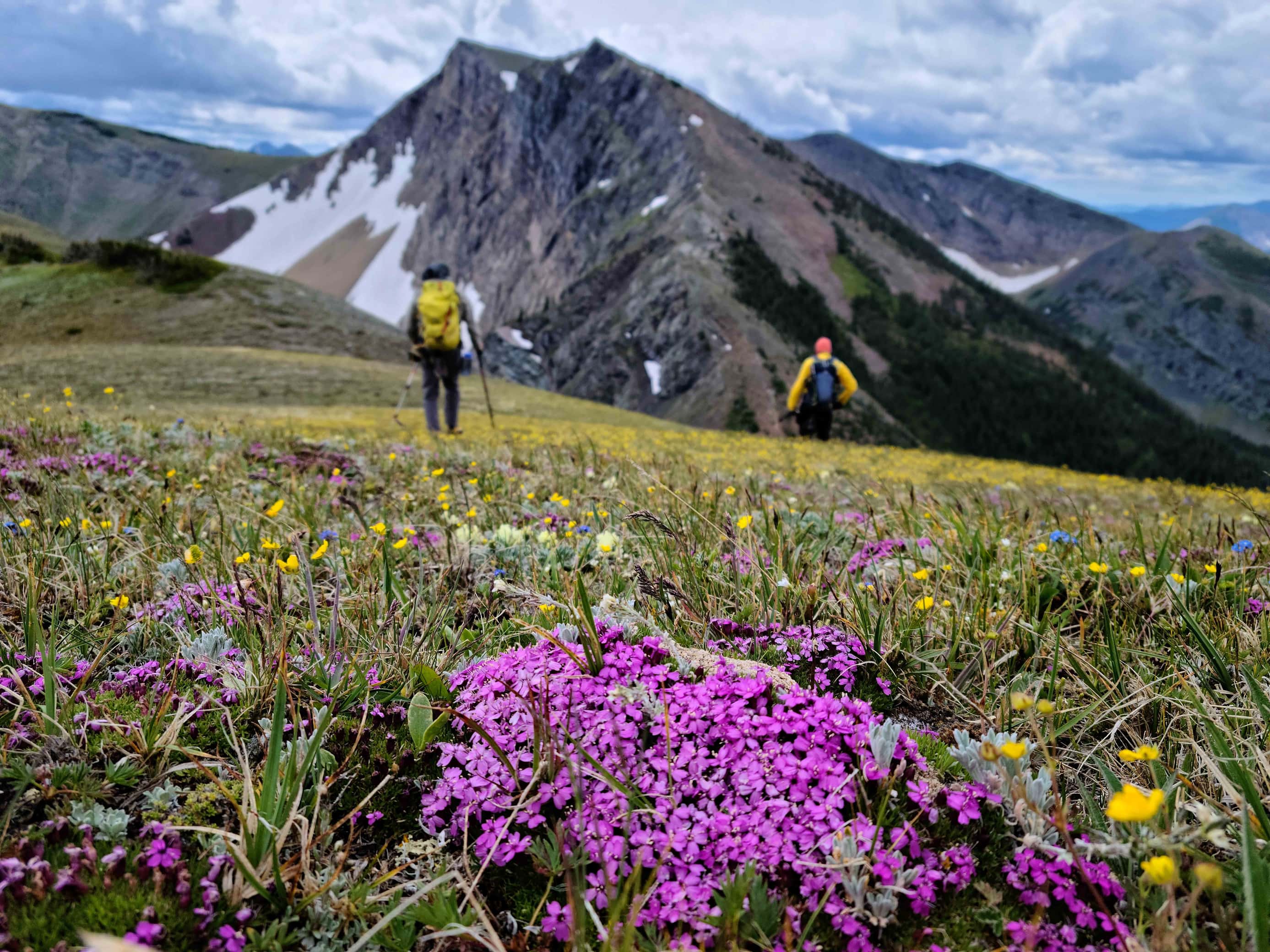
The little ridge was full of flowers.

Still wanting to explore more of the mountain, we began to head towards the eastern high point.

We had no issues side-sloping beneath the summit.

Arriving on the broad col between the summit and the eastern high point.

While Brad and I decided to climb the eastern high point, Andrew began to search for the trail down to the bowl.

Beginning the quick hike up.

That view to the north remains outstanding.

Closing in on the summit.

On the summit and gazing down at MacDonald Pass and the route used by Gord Blair et al, Matthew Clay and Sonny Bou.

The view towards the summit of Hollebeke. The smaller high point that we came from is on the far left.

Rain begins to fall on Packhorse Peak.

A different view of “North Kootenay Point” (foreground left) where we started the day.

I found this interesting metal tool on the summit. I believe it may have something to do with field butchering game – that, or there is a medieval torture chamber nearby.

Heading back to the col.

The trail leading to the bowl can be seen just above Brad where it cuts across the col.

Brad starts down the trail.

It was a very easy track into the bowl.

Andrew (lower right) waits patiently for us at an old campsite.

Reunited, Andrew leads the way down the trail.

Looking back to the col.

I don’t mean to toot my own horn but… 😂 (Photo by Andrew Nugara)

I think Brad may have found a new pipe… 😂

Continuing down the trail.

Western anenome.

The trail turned briefly into a lake, though we could easily bypass it by keeping to the right. (Photo by Brad Wolcott)

Crossing a small stream.

For the first ~2.5 km, the trail was very easy to follow.

Centre E3 (“North Kootenay Mountain”) is looking fine under afternoon sunshine.

Crossing a second small stream.

The trail was quite overgrown for last ~1.5 km, requiring a lot of bushwhacking.

Despite the overgrowth, we had little trouble staying on the trail.

Brad nearly disappears while passing through a section of thimbleberry.

Arriving back at the meadow where we left our bikes.

All of us were looking forward to the ride back.

The view from the meadow back to the NKP trail.

Fleabane welcoming the sun.

Another look at the junction where the two trails meet.

Enjoying a much quicker ride back.

Mount McCarty also looks great under the afternoon sun.

On the final stretch back to our vehicles.

Pausing for one last look at Hollebeke (centre).

Arriving back at our vehicles after a roundtrip distance of 36 km over 9 hours and 23 minutes, though if we had driven to the trailhead, we could have cut 8 km off the total. Once again, this was another fantastic day in the mountains spent with two awesome friends. Now that my interest in the area has been renewed, I’m looking forward to returning – and not waiting six years, like I did before. 😉


Leave a Reply