

⚠️ Hiking and scrambling are inherently dangerous activities. Please read my Disclaimer. ⚠️
This was my third trip to North Kootenay Pass (NKP) this summer, and I think I can finally say, that my curiosity has been satisfied. 😉 After ascending Hollebeke Mountain, “South FlatHead Peak”, and Mount Borsato over the last few weeks, Centre E3 was the last objective on my ‘To Do’ list for the area – not withstanding Centre SE1. I’ve been eyeing Centre E3 for many years and consider it to be one of those peaks that should have its own name based on separation and prominence. While officially labelled as Centre Mountain’s eastern outlier, I think E3 would be better served with a moniker such as, “North Kootenay Mountain”, just to give it some well-deserved character. Who knows, maybe there is a name that I don’t know about? However, in the meantime, I’m going to tag on “North Kootenay Mountain” as a geographically-based nickname because at 2396 m, it’s equivalent to nearby, Hollebeke Mountain.
Centre E3 is a natural objective for anyone visiting NKP. It’s an easy ascent that provides great views, and as Nathan and I discovered, can be descended in as little as 20 minutes if you choose the right scree slope and gully. Indeed, as we had brought bikes, the entire 23 km day ended up being only 4 hours and 45 minutes from start to finish – minus the few minutes that it took me to shake the dust off and check for injuries after doing an endo over my front handle bars on the way back. Fortunately, I did no serious damage to either myself or my bike and remain steadfast in my resolve not to change careers and become a middle-aged stunt man. 😂 All in all, this was great way to spend a beautiful summer’s day.
Be sure to read Andrew Nugara’s Centre E3 report from a few weeks earlier [link coming].

To get to North Kootenay Pass, drive south from the hamlet of Beaver Mines along Highway 774 for ~15.5 km until you come to the Lynx Creek (Ohagen Road) turnoff on your right (just past the Beaver Mines Lake turnoff). Turn and follow the Ohagen Road for ~1.8 km until you come to a fork and a sign that says to turn left to reach Lynx Creek. Like a good Canadian, obey the sign and turn left as going straight is now restricted access. Keep going for ~7.7 km until you come to a T-intersection. Turn left and follow the Carbondale River Road for ~2.6 km until the road forks to the right (Lost Creek Road). There is an information sign and a large area to camp just beyond this junction. If you have a high clearance vehicle, drive the remaining ~4 km over an increasingly rough road to the trailhead. We ended up parking ~700 m away from the trailhead but regardless of where you start, I recommend bringing bikes.
From the trailhead, it is ~3.0 km to reach the fork to MacDonald Pass. You will cross four recently constructed bridges in the process. Unless you want to ascend MacDonald Pass, keep going straight along the NKP trail. At the ~3.4 km mark from the trailhead, we came to the first of two, unbridged creek crossings, so be prepared for these. Around the ~5 km mark from the trailhead, we came to the second unbridged crossing (Carbondale River) followed by a ~3 km hike n’ bike to reach the entrance to NKP and the fork with the trail that leads towards E3.
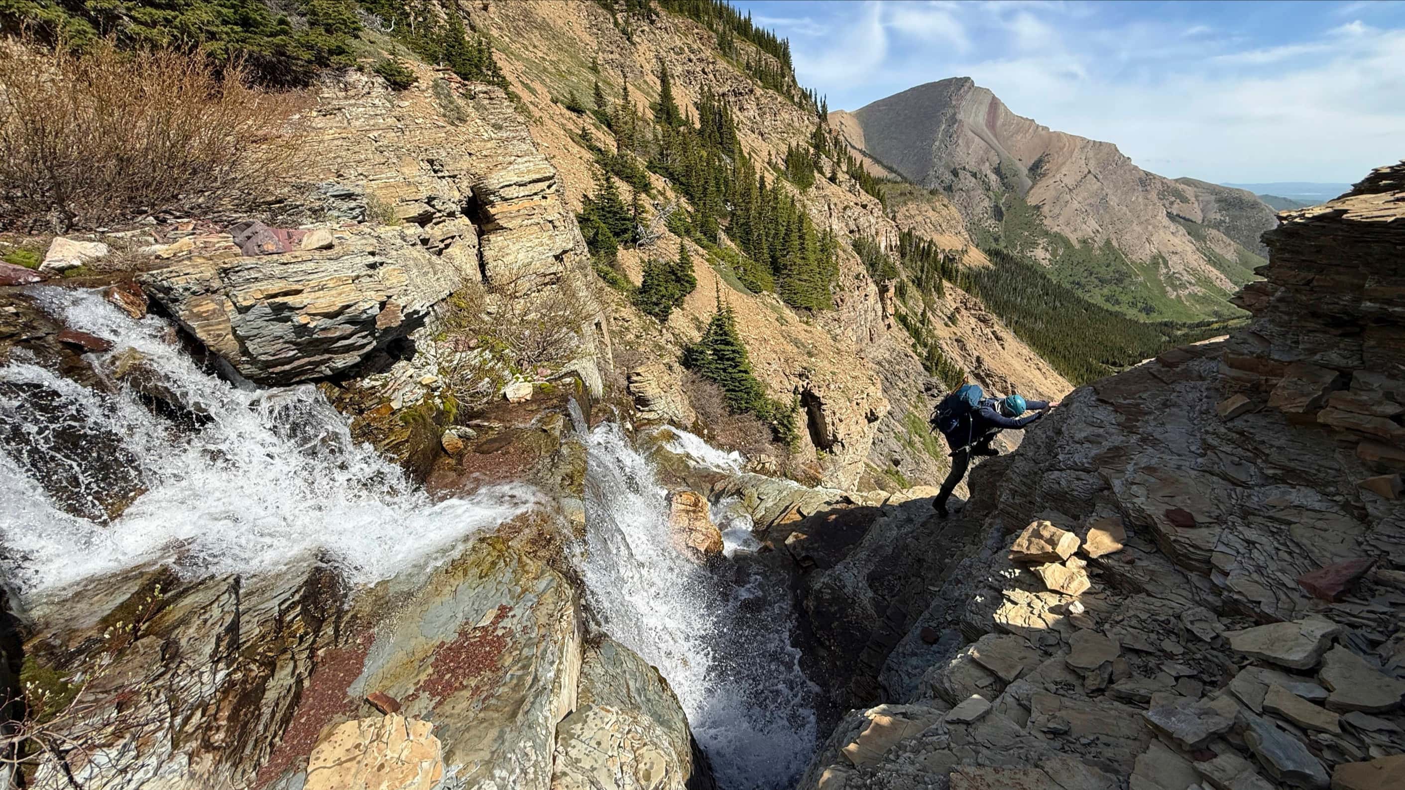
From the NKP trail we followed the E3 trail for ~350 m west (it feels weird to be walking away from the mountain you are going to climb) towards the base of “South Flathead Peak” and Centre SE1. We then followed a smaller offshoot north for another ~100 m until we were on the edge of a gully and could see the west ridge of E3 some 500 m away. After a bit of bushwhacking combined with some minor elevation losses and gains, we found ourselves on the west slope of Centre E3. From here it is an uncomplicated ~1.6 km hike (~402 m elevation gain) to the top. From the summit, we descended a scree slope/gully followed by a quick bushwhack through the trees to reach the trail and our bikes. We then returned along the NKP trail to our vehicle.

Our total distance travelled was 23 km with total elevation gains of 1054 m. Our total roundtrip time was 4 hours and 45 minutes.

Another gorgeous morning for a father/son bike n’ hike! As with my recent “South Flathead Peak” trip, we parked ~700 m from the actual trailhead – though in hindsight, the remainder of the road (right) was probably dry enough for me to navigate this time around.

Nathan rides across the bridge at the NKP trailhead. As I’ve highlighted this route in other trip reports, I will just say that this is the first of four bridges. There are also two unbridged stream crossings to be aware of as well.

Our first look at Centre E3 (right) as we ride in. In the middle is “South Flathead Peak” and Centre SE1.

Approximately 3 km from the trailhead, we came to the junction with the MacDonald Pass trail. We would keep going straight to reach NKP.

Getting a clearer look at Centre E3 as we near the Carbondale River crossing. Who knows, maybe there is a scramble route up the east or southeast sides?

Nathan crosses the Carbondale River approximately 5 km from the trailhead. This was the second unbridged stream crossing and represents the start of an extended period of bike pushing.

Hollebeke Mountain provides a moment of inspiration as we continue to push our bikes along the trail.

The appearance of “South Flathead Peak” (centre) means we are getting close to NKP…

Almost there! “South Flathead Peak” (left) and next to it, the impressive Centre SE1 (right) that Andrew and I failed to reach a couple of weeks ago.

Approximately 3 km from the Carbondale River and after ditching our bikes about ~150 m or so beforehand, we arrived at the entrance to NKP (left) and the fork with the trail we would use to reach Centre E3.

It felt weird to spend the first ~350 m, hiking away from Centre E3.

Centre E3 from the trail. The route up the west ridge is about as straightforward as you can get.

Gazing over to NKP (centre) as we gain elevation.

The trail eventually came to a ‘T ‘and we began to follow an offshoot northwards.

The offshoot only lasts for ~100 m, but it brings you to the top of a small gully and a clear view of the remaining ~500 m to reach the mountain’s west ridge.

It was easier to drop into the gully than bushwhack over to the small hill in the centre.

Mount Darrah (centre right) looks awesome today!

On the small hill and enjoying the easy walk towards the west ridge. There is a bit of bushwhacking, but nothing too difficult.

A minor elevation loss prior to reaching the west ridge of Centre E3.

Centre SE1 is an impressive peak!

It was an uncomplicated, but windy hike to the summit.

The west ridge offered good views of the Flatheads.

The view back features Hollebeke Mountain (left), NKP (centre), and “South Flathead Peak”.

A closer look at NKP (centre) and the feature we nicknamed, “North Kootenay Point” (left) on our Hollebeke trip. If your sole goal is NKP, it’s worth it to spend the extra time to ascend “North Kootenay Point” just to take in the views.

Heading towards the summit.

As we drew closer to the top, Centre Mountain (centre right) itself began to make an appearance, poking out from behind Centre SE1.

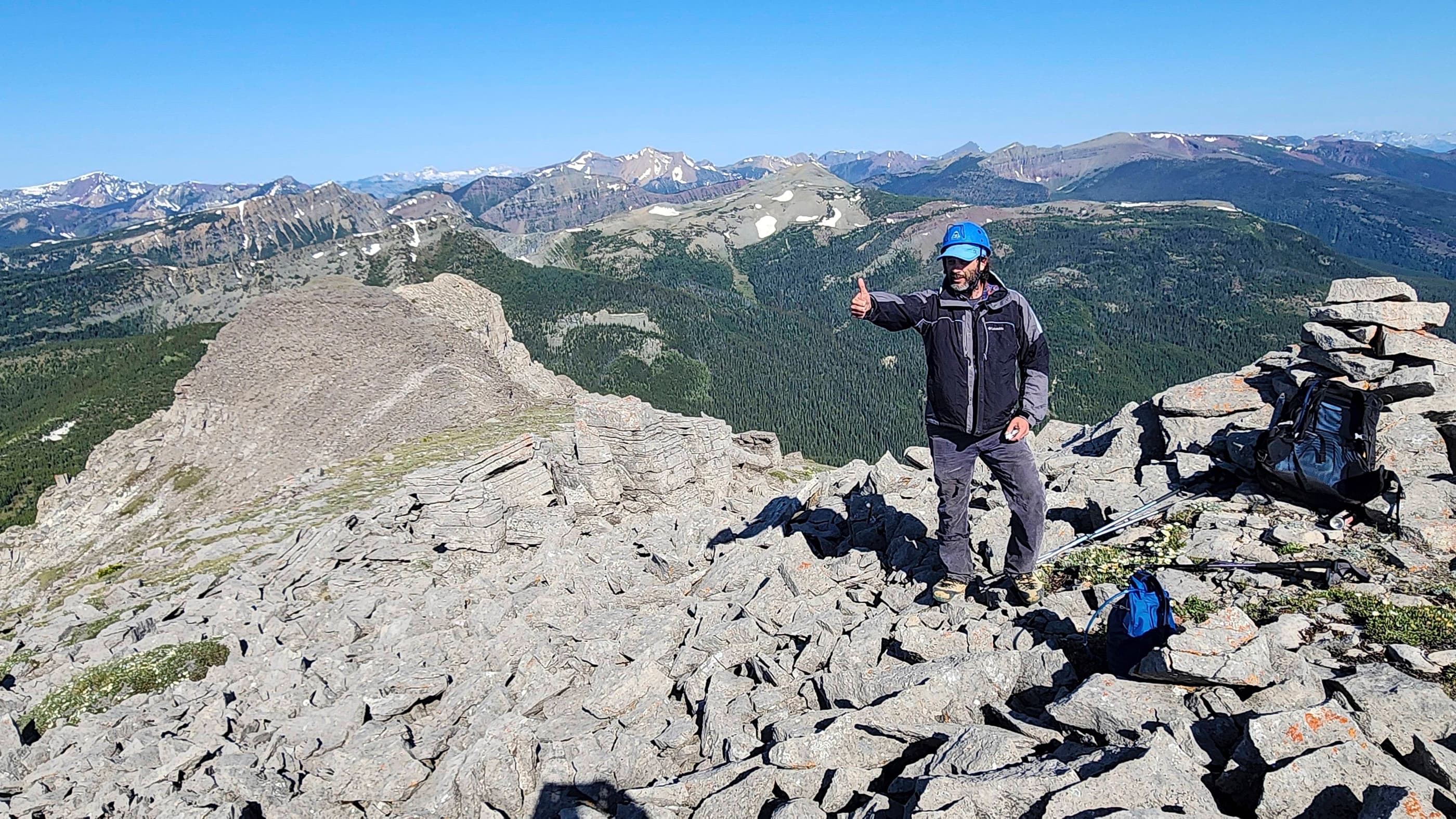
The summit of Centre E3 “North Kootenay Mountain” (2396 m).

A wide-angle to the west.

A wide angle to the south.

A wide gaze to the east.

Someone had built a small cairn on the lower point to the east.

A wide angle to the northwest.

A closer look at Centre SE1 and Centre Mountain (right).

Centre Mountain (left) and the uniquely shaped, Centre N1.

An even closer look at Centre N1.

A telephoto across the ridge to Barnes Peak.

Looking across to Centre N1 (left) and Darrah S2 (right) – and in front of S2 is Darrah S3. I’d love to find a way onto the N1 ridge from the east…

Looking northwest at Darrah S2 and S3 (left), Mount Darrah (centre), and Mount Coulthard (right). In the foreground is Darrah SE4, which like Centre E3, highlights the changing rock between the Flathead Range and the colourful Lewis Thrust.

A telephoto of Mount McGladrey, Ptolemy SE5, Andy Good Peak and Mount Coulthard (right).

A telephoto to the northeast of the Livingstone Range.

A closer look at Mount McCarty which sits to the southeast. The NKP trail is in the foreground on the left.

Centre E3 is a whole 4 m lower than Hollebeke Mountain – which essentially means nothing. 😂

Nathan takes the final few steps before joining me on the summit. As I always say, the best summits are the ones you do with your kids! 😊

Looking southwest with Nathan on the summit…

And then looking west.

Though it was a beautiful day, the wind was horrid, and this cut our summit stay short.

Instead of following the west ridge back, we chose to try our luck on a scree slope that we could see from the trail. I believe this is route that Andrew also used a few weeks prior…

As we could scree ski much of this, it only took us 20 minutes to reach the trail from the summit.

Glancing back to Nathan as he follows me down. The lower section turned into a gully which slowed us down, but it was not difficult to navigate.

The scree slope/gully that we used to descend is behind Nathan. The subsequent bushwhack to the trail was also quick, though we found ourselves backtracking to reach our bikes once we reached the trail. If you use this route, I would recommend leaving your bikes closer to the scree slope and gully.

The last time I was here, a rock slashed my tire and I ended up having to walk my bike all the way back. Here’s hoping that my new tires have tough sidewalls…

We made quick time covering the ~3 km back to the Carbondale River.

Crossing the Carbondale River.

One last look back to Centre E3 from the NKP trail. I’d better pay attention, because I would shortly find myself lying on the ground after doing an endo over my front wheels. Fortunately, neither I or my bike suffered any damage.

Our bikes ensured that it wasn’t long before we reached the trailhead…

And then ~700 m later, our vehicle. For an objective with a fairly long approach, this trip was very quick, coming in at 4 hours and 45 minutes. It was nice to finally knock Centre E3 “North Kootenay Mountain” off my list – and not have to think about coming back to NKP again. As always, it was awesome to spend a day in the mountains with one of my kids!

Leave a Reply