

⚠️ Hiking and scrambling are inherently dangerous activities. Please read my Disclaimer. ⚠️
Once again, a severe wind forecast dictated our mountain for the day. This is a normal but incredibly annoying feature of shoulder season hiking in southwest Alberta. Fortunately, many of the front range mountains offer multiple ways to the top, so even though you are forced into a repeat, you can often choose a totally new route – and in my mind, a new route equals a new mountain. 😊
Such is the case for Prairie Bluff (PB). This diminutive mountain has multiple routes to the top, from a leisurely hike along a trail to full-on scrambling and everything in between. Of my six times up PB, today was the most difficult of the four routes I’ve tried to date – an ascent directly up the rugged northeast face.
The idea and the intel for this route came from Brad, who successfully attempted this route with Dave Fuller six years ago using three snow-filled couloirs, each with progressive levels of difficulty. As the wind was forecast to steadily increase throughout the day, an ascent inside the shelter of some couloirs was highly appealing. That it would involve a much higher level of skill than any of my previous routes was both intriguing and motivating.
So, relying on Brad’s previous experience and expertise, we set off with a copious amount of gear that one would normally associate with a much larger mountain. However, the northeast face of PB is no joke and even though the mountain is not big, the difficulty combined with the unknown condition of the snow, made our heavy packs a necessity.
After following a small ridge to the start of the lower couloir, we found the snow in relatively good condition with the occasional pocket of post-holing. The ice however, was a different story as it was still too early in the year to be reliable, and so extra care had to be taken with the placement of our axes. There’s nothing like sinking your axe into what you think is solid ice, only to have the ice rip off as a block, leaving you holding what is essentially a large popsicle. Yummy! 😂
The lower couloir is the longest of the three and also the least difficult. The second couloir is steeper and narrower with two distinct ice steps that require careful stemming to overcome. The third and final couloir is the shortest and leads directly onto the summit. It is steeper and more exposed than the previous two couloirs and while it might be a straightforward scramble under dry conditions, the presence of ice and snow made it tricky. Though we never needed to use a rope, we did discuss it while trying to tackle the ice steps inside the second couloir, as a fall would be painful. Still, it was a good option to have.
The top of the third couloir emerges directly onto the summit and while we were gloriously sheltered from the wind for most of our ascent, once we popped up next to the cairn, we were instantly blasted by the bone-chilling wind. Struggling to stand, we immediately began our retreat down the south gully located between PB and “Prairie Fire”. From here we circled the base of PB back to the road and then to Brad’s car.
Though this was my sixth time up PB, the route up the northeast face made it into an entirely new mountain. If I were to mention mountaineering and PB in the same sentence, most people would probably laugh, but that’s what we did – and it was totally awesome! I’m now curious to explore some of the other couloirs on the northeast face, as there are more possible routes and given the wind in southwestern Alberta, that opportunity will probably come sooner rather than later.
Finally, and as always, a HUGE thank you to Brad for yet another glorious day in the mountains! 😁

To get to the northeast face of Prairie Bluff, we drove north on Highway 6 from Paahtómahksikimi (Waterton National Park) until we reached the Shell Waterton Complex Road (Township Rd. 43A). We then turned onto this road and drove west for ~9.1 km until we came to a junction with a gravel road near to the entrance of the plant. Here, we turned left and onto the gravel road where we continued straight for ~3.9 km until we came to Butcher Lake. We continued straight for another ~1.5 km, until we arrived a Shell pumping house which is the original Windsor Ridge trailhead. We kept following the road as it curved to the right, continuing along it for another ~3.8 km until we arrived at a small radio tower located on the left side of the road. This was our starting point.
From the road, we followed a small ridge above an obvious drainage for approximately 45 minutes or so (~1 km) until we were almost at the base of the mountain. We then headed to climber’s right and onto the start a parallel drainage located immediately to the northwest. This was the start of the lower couloir.
We then followed the lower couloir for ~170 m until it ended in an open area beneath an imposing set of cliffs. From here, we could see the start of the second couloir which was approximately 50 m away. The second couloir is actually part of a larger couloir that eventually connects to the drainage that crosses the road where we parked.
Once inside the second couloir and at the base of the cliffs, we were presented with a fork. Using Brad’s prior knowledge, we chose the one to climber’s left and made our way up its steep and narrow confines. There were two icy steps that we had to overcome which comprised the crux to this point.
Approximately 50 metres later, we emerged at the top of the second couloir and onto another open section. After skirting a small section of trees, we came to the third and steepest couloir. A short but very careful ascent saw us emerge directly onto the summit.
Blasted by the wind, we immediately dropped into a drainage located to the south between PB and “Prairie Fire”. From here we worked our way around the southeast end of the mountain and eventually back to the road. A short ~1.7 km hike brought us back to Brad’s car.

Our total roundtrip distance was 9 km with a total elevation gain of 680 m. Our total roundtrip time was 6 hours and 14 minutes.

Brad uses binoculars to check the snow conditions in the couloirs. Note the radio tower on the left and the small drainage in the foreground which makes our starting point easy to find.

Another view of our starting point with Christie Mine Ridge in the background. I ascended Christie Mine Ridge in 2021, but have never written a trip report.

Brad leads the way as we start along the drainage.

We will soon climb onto the ridge which is located to our right.

On the ridge and navigating through an aspen grove. Most of our approach was spent in the trees.

As the snow was firmer inside the trees, we avoided open sections until we were closer to the base.

Travel inside the trees alternated between light bushwhacking and semi-open sections such as this.

Firmer snow at a higher elevation meant that we could finally enjoy the open ridge.

The view back to Brad’s car.

Approximately 45 minutes or so after starting (~1 km), we came to the point (immediately in front of Brad) where we would head to climber’s right and onto the start of a parallel drainage.

Traversing towards the parallel drainage.

Our first look at the start of the lower couloir (foreground) and the unique rock formations around it.

Gazing up to the start of the couloir (left of centre).

A closer look at the couloir. This is a seriously cool location! 😁

The view back and along the parallel drainage with the ridge we followed on the right.

Gearing up before tackling the couloir, which in Brad’s case, involves drinking absinthe. 😂

Looking back to Brad as we start up the lower section.

As Brad used this route six years ago, I was happy to let him lead. 😁

The lower couloir quickly turned into a stunning argillite canyon.

Brad passes the first of two sets of ‘rabbit ears’.

Another look back shortly after starting up the couloir. The ridge and our route from Brad’s car are on the right.

The couloir begins to narrow.

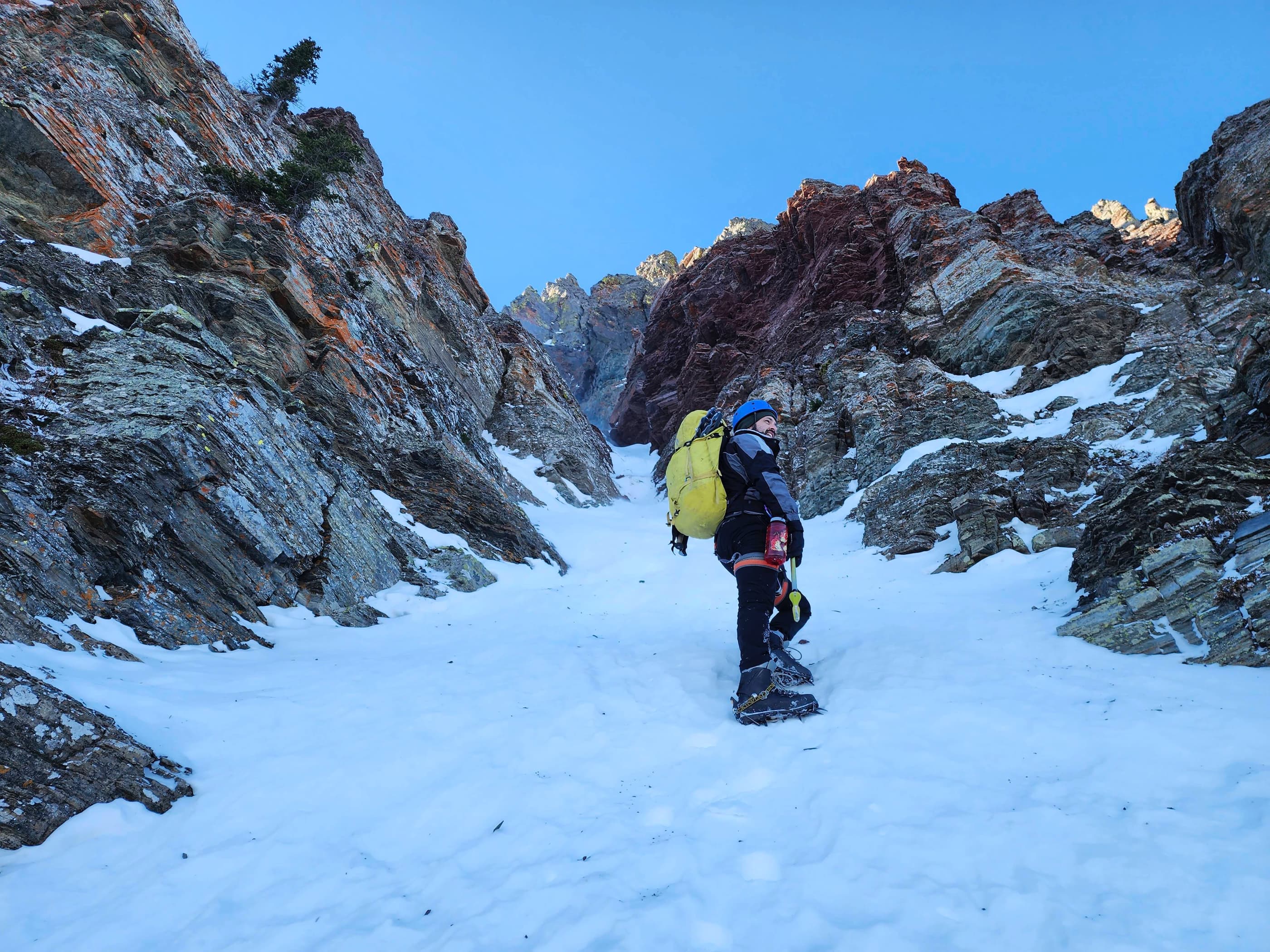
Tackling a section of deep snow and ice.

Continuing along the scenic couloir.

Steep terrain in the middle section.

Brad’s view back from the previous photo. (Photo by Brad Wolcott)

Brad passes the second set of ‘rabbit ears’.

More overhanging rock.

Heading onto the upper section of the couloir.

Brad’s vantage from the previous photo. What a super fun route! 😀 (Photo by Brad Wolcott)

The man, the myth, the legend.

Colourful lichen on the rocks above us.

The couloir curls around a corner.

Nearing the top of the couloir.

I navigate another section of ice. (Photo by Brad Wolcott)

Arriving at the top of the lower couloir.

Looking up to the second couloir which goes through the notch in the centre.

Despite the insane wind, this part of the mountain was almost completely sheltered. As a result, we were able to eat a leisurely lunch while enjoying the sunshine.

There was no shortage of interesting rock.

Heading up to the second couloir.

Glancing back.

More colourful lichen.

The second couloir is in the centre.

Still more overhanging rock.

Introducing Sammy the Syncline.

Brad follows me up as we head towards the couloir.

Arriving at the start of the second couloir. Note the fork where the second couloir continues to the left.

The second couloir is really the top section of a longer couloir that stretches back towards the base of the mountain. I’m definitely game to try this one day. 😁

Brad leads the way as we start up the couloir.

The second couloir was narrower and steeper than the lower one.

I climb over the small step in the previous photo. (Photo by Brad Wolcott)

Steep but manageable terrain.

Brad tackles the first of two tricky ice steps.

My view from the bottom of the step. It doesn’t look so bad from this angle…

But from Brad’s vantage, you can see how steep it is. (Photo by Brad Wolcott)

Brad expertly handles the second ice step.

Continuing our way up.

Glancing back as we near the top of the couloir.

Two couloirs down, one more to go!

A wider view of the previous photo.

The summit sits at the top of this cliff band with the third couloir located to the left of centre.

Approaching the bottom of the third couloir.

Navigating deep snow to reach the couloir. This was a crux in and of itself!

The view back to Brad’s car from the base of the third couloir.

Standing at the base of the couloir. (Photo by Brad Wolcott)

Zooming in on Brad as he follows me up.

The third couloir is not long, but it is steep and exposed. In the summer, this might be a straightforward scramble, but the addition of ice and snow definitely ups the ante.

Brad stems his way up…

and over a tricky obstacle.

Nearing the top of the couloir.

Only a few more steps…

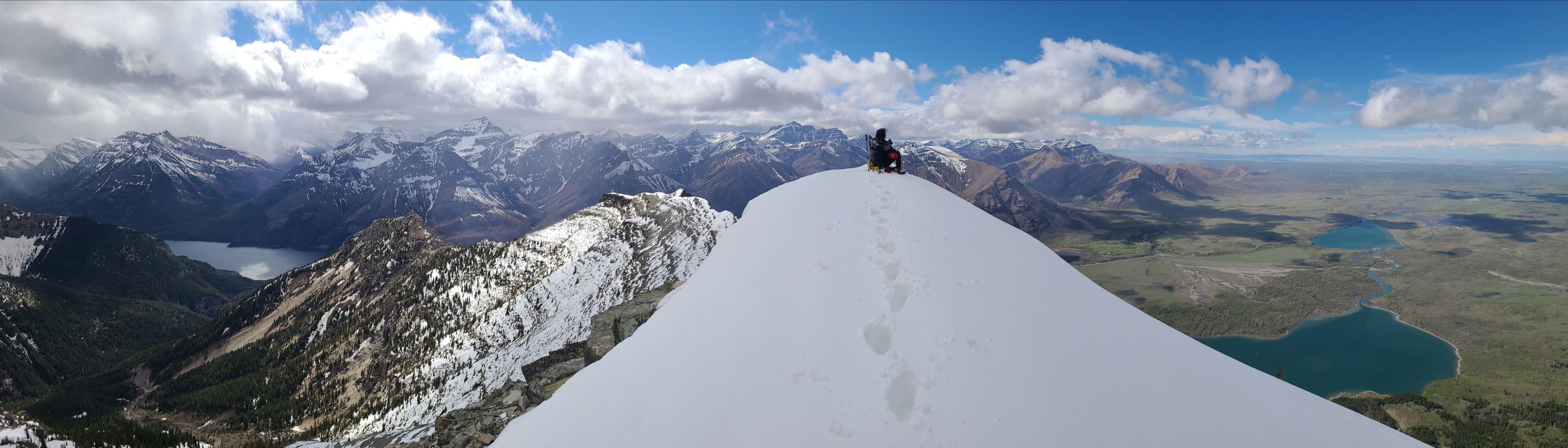
To reach the summit of Prairie Bluff (2258 m). Andrew better watch out because this was my sixth time on top, which means that I’m slowly catching up to the reigning PB Champ! 😂

An insanely strong and bone-chilling wind greets us on the summit.

I’m guessing that Brad might be the only person to have completed this route twice. Perhaps even more notable, he was accompanied both times by a Dave. 😂

Making a hasty retreat into the drainage between Prairie Bluff and “Prairie Fire”. The haze in the distance is spindrift.

Arriving in the drainage.

Taking advantage of the snow for a quick descent.

Looking back to the summit of Prairie Bluff (centre). It sure looks different from here compared to the northeast face. 😂

One of several frozen waterfalls on “Prairie Fire”.

The wind swirls around us.

“Prairie Fire” is one of four subsidiary peaks located between Prairie Bluff and Victoria Peak.

Heading across open slopes as we hike back to the road.

A great view of Prairie Bluff as we cross a meadow.

Arriving back at the road…

And settling in for the ~1.7 km hike back to Brad’s car.

Arriving back at Brad’s car 6 hours and 14 minutes after starting.

A late day look at the northeast face of Prairie Bluff. I’m now super curious to try some of the other couloirs, because it’s guaranteed that southwestern Alberta’s extreme winds will force us into a return trip.

Who’d have thought that you’d have to bring this much gear for Prairie Bluff? 😂 Seriously though, if you attempt the northeast face under winter conditions, you will want all of it, as this is one of the most difficult -but rewarding – routes to the top. A HUGE thank you to Brad for sharing his expertise and for being one of my favourite people to climb a mountain with. 😊


Leave a Reply