

⚠️ Hiking and scrambling are inherently dangerous activities. Please read my Disclaimer. ⚠️
Willoughby Ridge is a small volcanic formation that is located just south of the town of Coleman in the Crowsnest Pass. Immediately to its east lies Turtle Mountain and Hillcrest Mountain, and to its west lies the northern end of the Flathead Range. This strategic location allows for outstanding panoramic views of the entire area, which is why the Ironstone Fire Lookout is located on the summit. The Lost Creek Fire of 2003 left a unique mark on Willoughby, leaving half of the Ridge devoid of living trees including, somewhat ironically, the section surrounding the fire lookout.
I had first eyed Willoughby Ridge from the summit of Mount McLaren back in October, and thought that it would be a good objective for a winter hike. Well, winter arrived early in the mountains this year and after not being able to play outside for a few weeks, I was anxious to go for a hike – even if it was a short one. Joining me on this day was my friend, Graham, who was also chomping at the bit to get out and gain some elevation. Neither of us had time for tackling a long objective and the increasingly fierce chinook winds limited our options, so I picked Willoughby thinking that we could summit it given our late start time of 10:30 am and the need for both of us to be back in Lethbridge by 4pm. This would have been a very reasonable proposition had I made it in the summer, but it is now winter, and scrambling up the NW slopes through deep snow and over ice covered rock significantly slowed our progress so that in the end, we had to settle for merely tagging the NW end of the Ridge. Usually I’m not satisfied if I fail to achieve my summit objective, but in this case, Graham and I had so much fun trying to claw our way up the snow covered slopes (and then sliding down them on the way back), that this time it didn’t bother me. It was also helpful that the views from the NW end of Willoughby Ridge are fantastic.

Most of the trail guides that I have read, including my friend, Joey Ambrosi’s, Hiking the Southern Rockies, describe the route to the summit of Willoughby as following the access road which winds its way up the west side of the mountain from the North York Creek trail (you can see the fire road on the above image from Google Earth). I however, thought that a more interesting approach would be to ascend the NW slopes of the Ridge and then walk to the summit. After hiking up the North York Creek trail for approximately 2km (just past where the upper and lower trails merge) we exited the trail when we came to the first open slopes on our left hand side, and began making our way up through knee deep snow. This is an interesting route and not long after gaining some elevation, the views behind us began to open up. There are not many places where hands on scrambling is required, but with the amount of snow and the drifting that had occured, we frequently found ourselves wading through waist deep snow and using tree branches to pull ourselves along. The actual scrambling sections featured ice and snow covered boulders and making our way up these took some time and care.
As we went higher, the winds increased dramatically, and more than once, Graham and I were knocked around by intense gusts. We could tell by the spindrift at the top of the NW ridge that things were only going to get breezier. The final few metres to the summit saw us climbing and crawling through deep snow until we encountered rock that had been blown clear. After spending a few minutes snapping pictures we ventured along the ridge toward the actual summit. However, we soon realized that there was too much snow within the trees to allow us to make quick progress to the summit and still be back in Lethbridge by 4pm (note to self: next time bring snowshoes). The reality was that the time we had spent ascending had been significantly longer than we had anticipated. Coupled with this, was the fierce wind and the appearance of ominously dark and fast moving clouds over the Flathead mountains. So, we wisely decided to descend back down our ascent route (the original plan was to use a cutline on the northern slopes), which went much quicker because we could now slide down several sections. We arrived back in Lethbridge at 4:05pm which I think was pretty good timing 😉

I don’t think that my GPS liked the snow very much as it spent most of the day immersed in the fluffy stuff even though it was inside the waist pocket on my pack. The giant elevation gain shown near the end of the hike is probably an anomaly caused by its hatred of snow – that or I somehow forgot climbing a 100m vertical cliff face. The distance is accurate though, as the total round trip was 6.9km with a total time of 3 hours and 56 minutes – though ascending and descending this route in the summer would probably take half the time. My cranky GPS said that the summit of the NW end of Willougby was 1989m. I definitely would recommend the NW end as an all season objective by itself for those looking for a quick outing coupled with great scenery.

It may be early November, but there is already a significant amount of snow in the backcountry.

Soon after we hit the trail, blue sky began to appear above North York Creek.

Graham walks along the North York Creek trail toward our ascent slope in the distance. The snow on the trail had been packed down from recent snowmobile activity.

Shortly after the lower trail merged with the upper trail, we could see this open slope through a sparse section of trees on our left hand side. This exit point is easily identified because the trail climbs for a hundred metres or so after the merger but then begins to dip down. We accessed the above slope just before the trail began to lose elevation at the dip.

After a short climb through knee deep snow, we came to this drainage where we could see the top of the NW ridge in the distance (just to the left of the first tall evergreen to the right of centre). We crossed the drainage and followed the ridge on the right hand side until it arrived at the base of the false summit in the foreground.

You don’t have to hike very long before some great views begin to appear. From left to right: Mount Coulthard, Andy Good Peak, Mount Parrish, Mount McLaren, and Chinook Peak.

Looking at the false summit from higher up the ridge. We would have our first of many encounters with deep snow while trying to scramble up this little guy.

Graham stands on the initial ascent ridge with the Flathead Range behind him. Yes, this man is wearing shorts and gaiters! Here the snow is only a few centimetres deep…

…and here it is almost waist deep. Can you say shrinkage?

At the bottom of the false summit, Graham navigates upwards through the snow. This became a typical scene for us as the day went on – and we loved it, though it easily doubled our ascent time.

Looking directly west from the false summit. In the distance from left to right: Phillipps Peak, Mount Tecumseh, Mount Erickson, “Deadman Peak”, and Crowsnest Mountain. The southern summit of ‘The Saddle’ (a.k.a Star Creek Hill) is in the foreground.

Looking down at our route from the false summit. In the distance from left to right: Crowsnest Mountain, Ma Butte, and McGillivray Ridge.

Graham drags himself up and over the snowy slopes using a stick for an anchor.

More typical conditions for the day. How are those shorts working for you Graham?

At some point, snowshoes would have been helpful… (Photo by Graham Reimer)

Graham scrambles up from a section of rock and onto a small shelf. Behind him from left to right: Mount McLaren, Chinook Peak, Sentry Mountain, and Mount Tecumseh.

A unique rock formation on the upper slopes. It was here that we began encountering wind gusts that would at times, knock us to the ground.

Hey! Let’s go for a winter hike! How much snow can there be in early November? (Photo by Graham Reimer)

The last section before reaching the NW end of Willoughby Ridge.

Closing in on the top of the Ridge. (Photo by Graham Reimer)

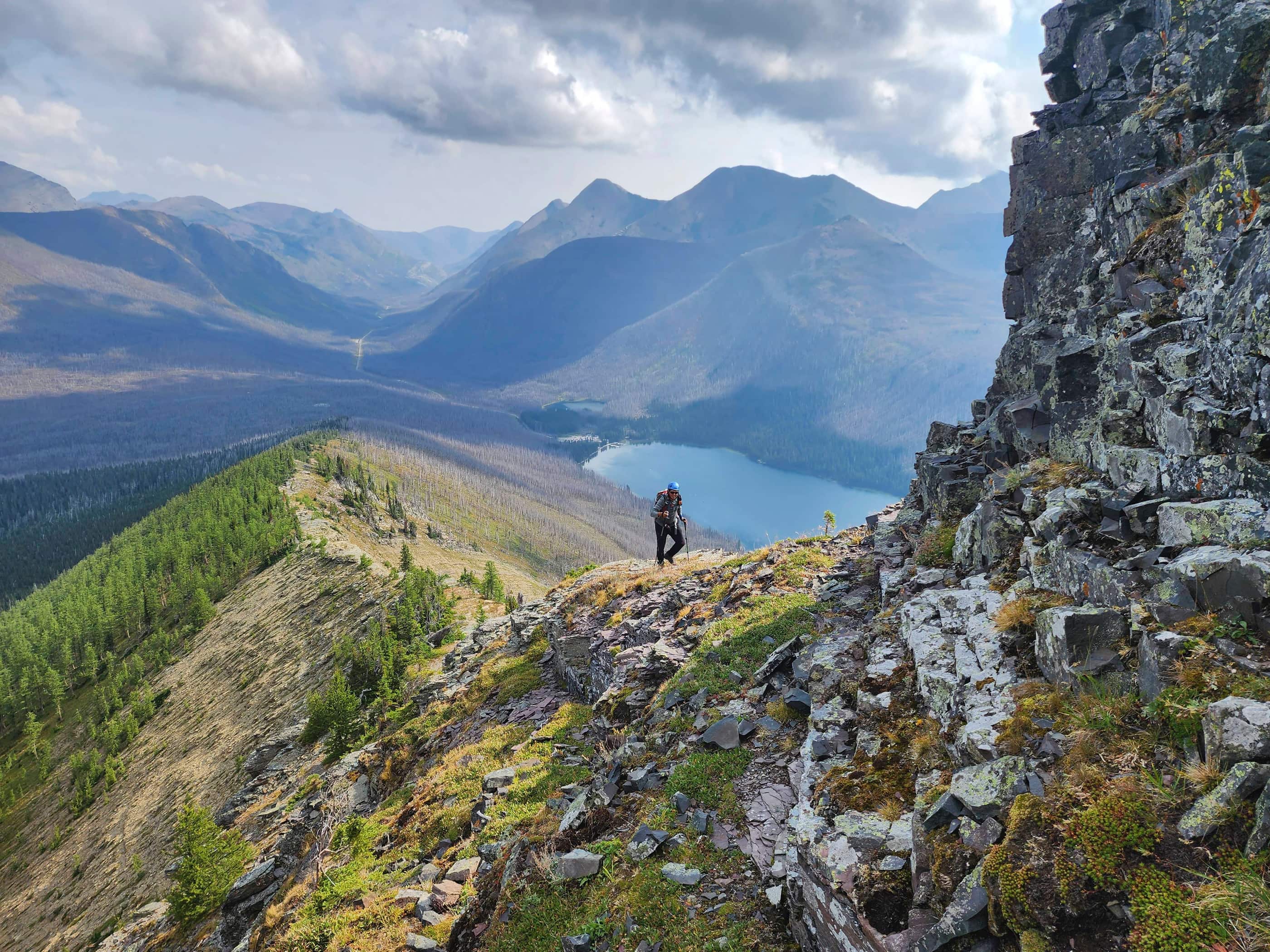
Looking southeast from the NW end of Willoughby Ridge. The true summit and the fire lookout can be seen on the right. Here is a video that Graham took of the surrounding landscape.

Looking west from the NW end of Willoughby Ridge. From left to right: Mount Coulthard, Andy Good Peak, Mount Parrish, Mount McLaren, Chinook Peak, Sentry Mountain, and Mount Tecumseh.

Looking west towards Phillipps Peak, Mount Tecumseh, Mount Erickson, “Deadman Peak”, Mount Ward, Crowsnest Mountain, The Saddle, Wedge Mountain, Ma Butte, and McGillivray Ridge.

Looking east from the NW end of Willioughby Ridge. From left to right: Bluff Mountain, the South Peak of the Livingstone Range (behind Bluff Mt.), Robertson Peak, Tallon Peak, Turtle Mountain, Burmis Mountain, and Hillcrest Mountain.

Looking north toward Saskatoon Mountain, Grassy Mountain, Bluff Mountain, and the Livingstone Range.

Graham on the top of the NW end of Willoughby Ridge (1989m).

Though not as strong as the winds that I encountered on the top of Mount McLaren, the wind gusts on top of the ridge were strong enough to knock us down.

Looking back toward Mount Tecumseh and the NW end of Willoughby as we explored our options of getting to the actual summit. Unfortunately, after assessing the situation given the time we had left, the deep snow in the trees between us and the fire road, the fierce wind, and the rapidly changing weather, we decided to call it a day and descend back to our car. Still, it was an awesome little adventure and I will return to complete the entire route. (Photo by Graham Reimer)

Some nasty weather moved in quickly from the SW.

Graham does his best impersonation of a marmot.

Arriving back at the vehicle. The NW end of Willoughby Ridge is a great little destination if you are limited for time and want to experience some stellar views.


Leave a Reply