
⚠️ Hiking and scrambling are inherently dangerous activities. Please read my Disclaimer. ⚠️
For the second year in a row, I once again found myself snowshoeing at the beginning of October. This past week’s, ‘Snowmaggedon’ dumped upwards of 100 cm on the mountains and left almost 60 cm of snow in my driveway in Lethbridge. Knowing that hiking anything with elevation today was out of the question, Brad and I set our sights on the front range foothills of the Castle, where there are numerous winter destinations. As the second last foothill on my checklist for the area (Christie Mine Ridge is the last), “Yarrow Ridge” sits at the northeast end of Mount Yarrow. It first caught my attention when Bob Spirko ventured onto it in October 2010 in search of a way up MountYarrow. Then last January, Andrew and I had a chance to check it out from the other side of Blind Canyon, as we ascended “The Eaglet” and “Raptor Peak” on the northeast end of Spread Eagle Mountain. So when Brad suggested it as the day’s destination, I was more than willing!
Now here’s where things get interesting. What should have been a snowshoe/walkup with options for scrambling, ended up as a bit of a wild day. For starters, the wind was absolutely INSANE! Without hyperbole, it was the worst wind that either of us have ever encountered. I know, I know, it’s southwestern Alberta and there are always strong winds. However, today’s wind was such that we had to crawl on the summit of the first high point because standing was next to impossible. It was definitely worse than what we experienced on Mount McLaren back in 2013, and with a few hundred trips under our belts as a baseline, neither of us can remember such a sustained struggle. It was so bad, that we couldn’t make the simple hike to the summit of the tallest high point on the ridge and to make matters worse, dropping onto either side of the ridge made absolutely no difference. It was as if we had resistance cords attached to our backs, doubling the workload.
Even before the ridge, the wind dictated our route as we snowshoed as long as possible within the trees, before finding a narrow line of shelter up the north face. After reaching the first high point, we wanted to get off the mountain as quickly as possible and decided to drop down the east slope. Here, Brad discovered that we could easily glisssade three quarters of the way down. Meaning that while it took us ~2 hours to reach the first highpoint, we made it back to cutline next to Yarrow Creek in ~15 minutes. This was fantastic! When coupled with a scramble route that turned a bit more technical than we were expecting, “Yarrow Ridge” more than made up for its diminutive stature. I am definitely going to make another trip back this winter when I don’t have to walk into jet engine. 😉

To get to “Yarrow Ridge” from Lethbridge, drive west on Highway 3 to Pincher Creek. Then take Highway 6 south for ~27 km until you come to the Twin Butte General Store. Continue south on Highway 6 from the entrance of the store for another ~4.2 km until you come to the junction with Township Road 34. Turn right and onto Township Road 34 and drive west for ~8.2 km until you come to a T-intersection with Range Road 303. Turn left and proceed for another ~1.3 km until the road ends. This is where you will park.
The field immediately to the west of Range Road 303 is private and is demarcated by an electric fence marked with numerous, ‘No Trespassing’ signs. The trail begins at the parking area and crosses through a deliberate opening where a fence leading to the east, intersects with the electric fence. Follow the trail alongside the electric fence for ~300m towards an obvious cutline. You will soon arrive at a gate with a sign that says, ‘Please Close the Gate’. Go through the gate (making sure to shut it) and follow the cutline south until you come to open slopes that lead to the north end of the mountain. To stay out of the wind, we ended up following the electric fence west from the gate and through the trees. We eventually branched off after ~200 m or so and headed towards the mountain. We then ended up following another fence until we were directly beneath the north face. This fence was not marked with ‘No Trespassing’ signs, but we assumed that it still demarcated private property, so we did not cross it. Just prior to the base of the mountain, it suddenly disappeared and we had easy access to the mountain.
There are a number of different routes up the mountain from here, but note that it all looks less steep than it actually is! Once on the ridge, it should, and I repeat should, be a simple hike to reach both high points – unless of course you are being blasted by a jet engine… 😉 . There are also lots of options for getting off the ridge as well, but where we descended to the east, immediately beneath the first high point, it is pretty much a straight line back to the trail.
 This was a short trip with a total roundtrip distance of 6.7 km with total elevations gains of 776 m. Our total roundtrip time was 3 hours and 53 minutes.

The first sign that it’s going to be a day of insane wind? When you can barely open the passenger door because of the counterforce. The second sign? When your cap is immediately ripped off your head and you have to chase it through the snow for 10 minutes to get it back. Yup, this all happened within minutes of arriving at our parking spot. “Yarrow Ridge” is on the left with Mount Yarrow in the centre and Spread Eagle Mountain on the right.

Brad did not want to chance driving his car down to the actual parking spot at the end of the road, so we made the quick walk from our location near a small building. The cutline that we are aiming for is past the end of the road. “Yarrow Ridge” is on the right.

The trailhead begins here. Instead of using the gate, there is a small gap that it goes through where the fence in the foreground intersects with the electric fence on the right.

Brad walks past one of many, ‘No Trespassing’ signs.

Approximately ~300 m from the trailhead, we came to the entrance to the cutline.

Once through the gate, we chose not to follow the cutline, but rather, the fence pictured on the right as it led through the trees. This gave us some shelter from the wind.

As soon as we entered the trees, we had to put on our snowshoes.

After following the fence for ~200 m, we left it in favour of making a beeline towards the mountain.

If it weren’t for the wind, it would have been an awesome day weather-wise!

Our route went up the centre of the slope in front of Brad.

Every time that we had a choice between being out in the wind or slogging through knee-deep collection sites, we chose the slog. (Photo by Brad Wolcott)

Brad follows me up a firm snow drift. In the background on the left, you can see Brad’s car parked next to a small building.

Letting Brad break trail. 😉

Glancing northwest at “Raptor Peak”(left) and “The Eaglet”.

We followed this fence until it abruptly ended at the base of the mountain.

The view up the northeast slope. The wind was so strong, that I had to take this picture lying down.

A herd of sheep take refuge among the rocks.

Brad scouts the route ahead. We found a narrow line up the slope where the wind was tolerable; however, it ended up being much steeper than it appeared from the base.

We initially thought about heading up the small gully on the left, but it ended up being steep, ice-covered terrain. We eventually found a way up the snow on the far right.

Brad (lower left) checks out the gully from the previous picture. As I’ve already noted, it was much steeper than it appeared from below.

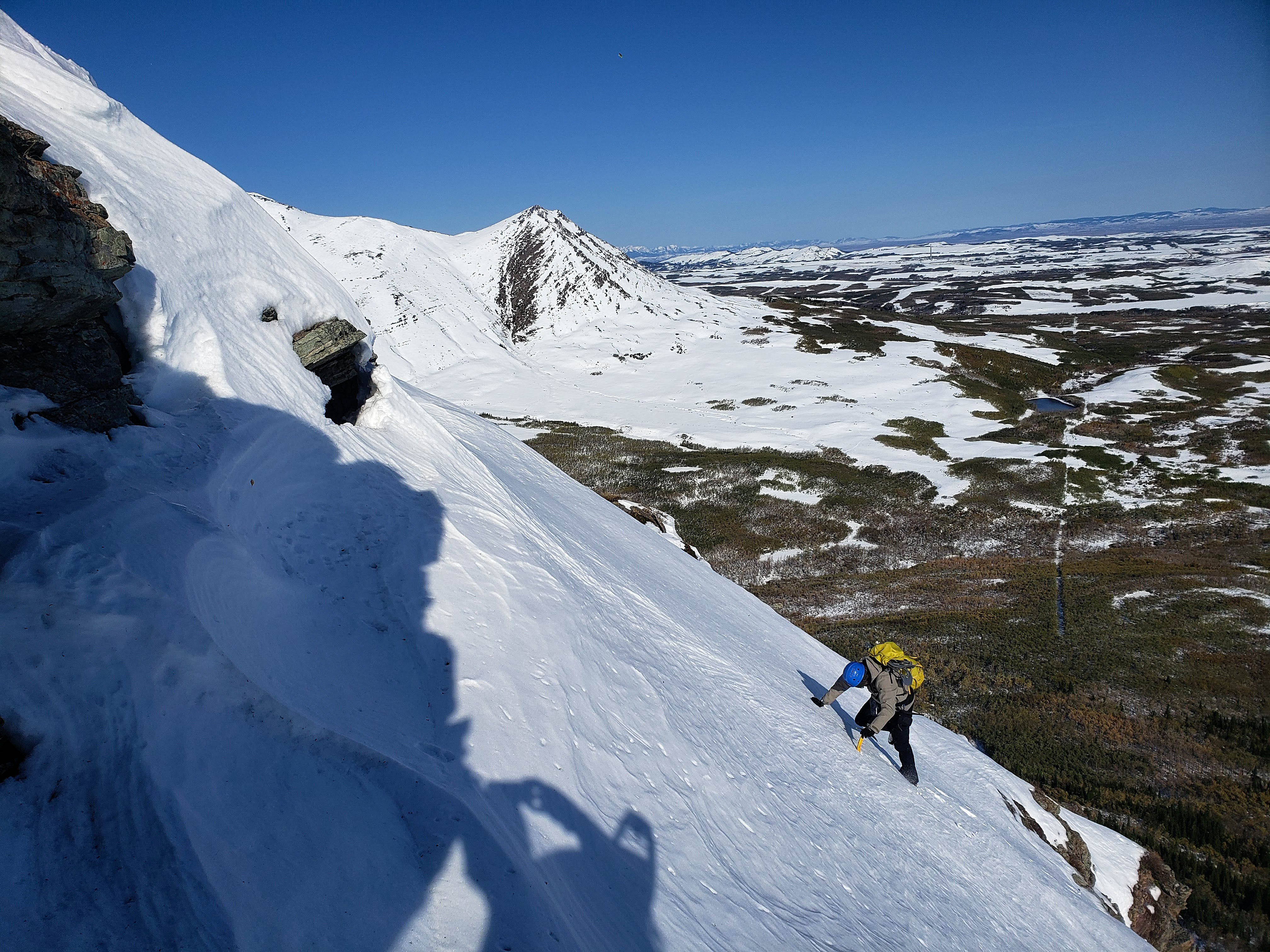
Scrambling up a series of small shelves. This was where things got interesting… (Photo by Brad Wolcott)

Brad takes advantage of good snow to climb a short but steep section.

Gracefully making my way over to the rocks on the left. 😉 (Photo by Brad Wolcott)

With the short scrambling section behind us, we now begin to feel the full wrath of the wind. Spread Eagle Mountain is behind Brad, with “Bakery Peak” on the far right.

Another picture taken while lying down. The two high points on the ridge are in front of Brad as he struggles to gain ground.

While I stuck to the ridge, Brad dropped down to see if he could find reprieve from the wind. He didn’t…

Again, lying on my stomach and taking a picture from the summit of the first high point. The second, and highest point on the ridge is in the foreground with Mount Yarrow behind it. On the right is Spread Eagle Mountain.

A more comprehensive view of the previous picture.

The view to the northwest and across Blind Canyon to “Raptor Peak” and “The Eaglet”. “Bakery Peak” on the northeast end of Loaf Mountain is to the left of centre. There is a very interesting account of Blind Canyon and “Bear Paw Cabin” that Bertha Marshall (namesake for Bertha Peak and Lake in Waterton) built in the 1930s. I discovered this after buying Fran Genereux’s, Being Bertha: How a Wayward Woman Became a Local Legend (2017) from the Twin Butte General Store on our way back. Definitely a book worth reading if you are interested in the local history of the area!

The view south at “Cloudy Junior” (right of centre), Cloudy Ridge (right), and Mount Dungarvan (left of centre).

Gazing southeast at Lakeview Ridge (middle distance and left of centre) and beyond it, Ninastako.
Crazy wind!

Brad on the summit of the first high point (1981m). There was no way that we were going to ‘walk’ to the second high point, even if it is slightly higher.

I was originally making a ‘W” for wind, but a gust blew one of my fingers off… 😉 I will come back later in the winter and tag the second high point and recover my finger.

Brad makes a hasty retreat off down the east slope beneath the first high point. The wind knocked us over several times…

…until it became way easier to glissade down.

Following Brad down the first of three sections where we could glissade.

Looking back up the first section.

Now looking back up the second section.

Brad makes the quick traverse over to the third section.

Brad arrives at the bottom of the third and final glissade.

The view back up to the first high point. It took us ~15 minutes to make it down to this point.

Brad checks out Yarrow Creek from the trail.
In the ‘shelter’ of the cutline… 😉

There are several options for ascending the northeast end of “Yarrow Ridge”. Our route went up on the far right.

Following the cutline back to Brad’s car.

A pano from road. From left to right: “Yarrow Ridge”, Mount Yarrow, Spread Eagle Mountain, “Raptor Peak”, and “The Eaglet”.

Arriving back at Brad’s car after 6.7 km and 3 hours and 53 minutes. As with earlier in the day, I struggled to open the passenger door against the force of the wind, though Brad did get awesome gas mileage on the way back to Lethbridge! It it hadn’t of been so insanely windy, it would’ve been a fantastic day weather-wise, so I’m definitely looking forward to returning later in the winter to enjoy the scenic little ridge walk. Of course, and as always, it was great to spend the day with Brad!

When we were driving in this morning, I noticed a church sitting up on a hill with fantastic views. Brad, being a well-informed religious studies instructor, told me that it was St. Henry’s Catholic Church, and that we could stop by for a visit on our way back. Built in 1907, St. Henry’s is no longer operational, but is diligently maintained by the Historical Society of St. Henry. Here is more information on the history of the parish if you’re interested. It definitely is an interesting building in a beautiful locale.


Leave a Reply