

⚠️ Hiking and scrambling are inherently dangerous activities. Please read my Disclaimer. ⚠️
Well, that was an adventure! 😳 If I were going to make a movie about today (think, Threat Level Midnight), it would fall somewhere between the genres of action and horror, with perhaps a musical score thrown in for good measure. As for the plot, well, I’d probably break it down as follows:
Cloudy Junior: The Movie
Part 1 – Cinnamon Fireballs: In the opening scene, the four main characters – a physicist, a biologist, a scholar of religion, and an historian – gather early on a beautiful March morning at the Yarrow Creek trailhead in the Castle. They discuss the day’s plan for ascending, “Cloudy Junior”, a prominent outlier of Cloudy Ridge in Waterton. The physicist, who has ascended “Cloudy Junior” on two previous occasions – once using the route outlined in Mike Potter’s, Ridgewalks in the Canadian Rockies, and once using what he calls, “The Devil’s Drainage” – is happy to be trying what he thinks is a new route, though he can’t shake the feeling of déjà vu.
As the group prepares, the biologist hands out small bottles of Cinnamon Fireball whiskey, while the scholar of religion suggests packing technical gear because they will be aiming for the true summit and not the lower point described by Potter. In fact, the physicist has written about the actual summit in, More Scrambles in the Canadian Rockies, describing it as a moderate scramble with a few difficult moves. The possibility of snow makes bringing the extra gear reasonable and the group sets off from the trailhead in good – and with good, spirits.
Part 2 – The Devil’s Playground: On approach, the group further discusses a north ridge ascent of “Cloudy Junior”, concluding that if time and conditions permit, they should try to reach Cloudy Ridge and “Cloudowan Peak”, before returning along “Cloudowan’s” neighbouring north ridge. The four friends naively assume that ascending the north ridge of “Cloudy Junior” will be a fairly quick endeavour, since it stretches down to meet a road. Sure, they surmise, the first ~1.3 km is treed, but even with some snow, it should be a straightforward hike to treeline. Meanwhile, the physicist still can’t shake his feelings of déjà vu.
The horror that awaits inside the trees is reminiscent of Saw – where the group must choose the manner in which they will be tortured and die. At first, the friends start up a drainage, but after the historian plunges into moving water, they decided to head onto the ridge proper. Here, they are greeted with two choices: struggle through waist-deep snow on more open slopes, or partake in heinous bush-whacking to avoid the snow. They choose the latter where possible; however, progress is agonizingly slow and it takes almost two and a half hours to reach treeline. Thankfully, the scholar of religion loves to break trail, and gladly takes the lead, using unique guttural vocalizations as motivation. [cue musical score]
Part 3 – A Blaze of Glory: Relieved to be on the open ridge, the group settles into the easy ascent, trending climber’s left and towards the summit ridge just prior to Mike Potter’s terminus. A short scramble brings them face-to-face with an enormous cairn; however, the true summit looms imposingly before them. Fortunately, the physicist is able to retrace his steps, and the group enjoys an extremely fun scramble to the summit of “Cloudy Junior”. Unanimous in assessment, the group considers the scramble to be moderate in nature, coupled with a few sections of exposure. Excellent route-finding skills are a must for this peak.
After enjoying glorious weather, blazing cinnamon fireballs, and great views from the summit, the four quickly conclude that given the time lost in the trees – or the “Devil’s Playground” as the historian calls it – and the imposing nature of nearby, Cloudy Ridge, that it’s time to head back. Meanwhile, the physicist still can’t shake his feeling of déjà vu.
Part 4 – Descent into Madness: After discussing the use of Potter’s route to return, the group decides it’s better to dance with the devil they know, and begins to descend the north ridge. However, after reaching the treeline, they change their minds in favour of the drainage they had started in. Moments after reaching it, the physicist suddenly recalls the source of his déjà vu – a long repressed memory that he has been here before, and it was… hell. 😳
At first the drainage is welcoming, and the physicist begins to question his memories. Then the group comes to a large ice fall at the head of a massive gorge. Forced onto the opposite ridge from ascent, the scholar of religion and the physicist forge a trail through waist-deep snow and across steep slopes. They can see that the gas road is oh, so close, but getting there proves to be an agonizing process. Descending back to the drainage brings a feeling of temporary relief, but the four are soon confronted with a new challenge. Two large, and impossible to avoid, drop offs welcome the group into the bowels of the gorge – or the “Devil’s Anus” as the historian notes. Thankfully, at the suggestion of the scholar of religion, the four had brought climbing gear, because otherwise, they would be S.O.L. as the sun was now setting. Two rappels and three and a half hours later, the group is finally free of the sphincter and are left standing on the road.
Part 5 – Into the Sunset: In the concluding scene, the four friends make the ~3.8 km march to the Yarrow Creek trailhead under twilight, silently enduring the elevation gains of the cutline. They arrive nearly eleven and a half hours after first setting out, and enjoy some Cokes while discussing the day. The historian notes that while the approach may work better in summer – with the operative word being ‘may’ – he doubts its ongoing viability, given the repressed memories of the physicist and their own lived experience. However, he also observes that once on the north ridge, the ascent and subsequent scramble are superb. The movie concludes with the four friends parting ways, vowing to let the physicist pick their next adventure, that is if he can remember where he has – or has not been before.
Cast:
The Physicist……….Andrew “I think I’ve been here before…?” Nugara
The Biologist……….Mark “Fireball” Klassen
The Scholar of Religion……….Brad “Trespass” Wolcott
The Historian.……….Dave “First No-Thyroid Internet Ascent” McMurray
Recent Reviews:
“A disturbing cast of characters that left me cheering for the Devil.”
“A pointless undertaking with no discernible benefit to humanity.”
“March of the halfwits.”
“Makes ‘Hercules in New York’ seem Oscar worthy.”
“Male pattern weirdness.”
Be sure to watch Andrew’s franchise reboot!

To get to “Cloudy Junior” from Lethbridge, drive west on Highway 3 to Pincher Creek. Then take Highway 6 south for ~27 km until you come to the Twin Butte General Store. Continue south on Highway 6 from the entrance of the store for another ~4.2 km until you come to the junction with Township Road 34. Turn right and onto Township Road 34 and drive west for ~8.2 km until you come to a T-intersection with Range Road 303. Turn left and proceed for another ~1.3 km until the road ends. This is the trailhead.
The field immediately to the west of Range Road 303 is private and is demarcated by an electric fence marked with numerous, ‘No Trespassing’ signs. The newly signed trail leaves the parking area and follows alongside the electric fence for ~300 m towards an obvious cutline. You then cross through an open gate and onto the cutline.
The trail continues along the cutline for several kilometres as it parallels “Yarrow Ridge” until it eventually merges with a road just prior to a large gas plant. Approximately 80 m beyond the gas plant, you will come to a junction on the road. Take the road to the left and cross the bridge (~3.7 km from the trailhead). The north ridge begins immediately on the other side.
Though it is only ~1.3 km (as the crow flies) from the road to the treeline of the north ridge, be prepared for some nasty bushwhacking in the lower reaches. There seems to be more open areas further to the east of the drainage, but as these were full of snow, we stuck to the trees as much as we could. Who knows, in the summer these areas may provide a route?
Once above the treeline, the north ridge becomes an enjoyable ~ 1 km hike to the summit ridge, with several small rock bands that can either be scrambled or avoided. From the ridge, a short scramble brings you to the ‘summit’ of Potter’s route, with the true summit still another ~500 m to the west.
We avoided the first major cliff by keeping to climber’s left before scrambling up to climber’s right to regain the ridge. Overcoming the next section of cliffs required us to stay climber’s right along the face while searching for a way up. We found a weakness that required a few difficult moves to get onto, but once on it, it was moderate scrambling with some exposure. We tackled the final obstacle before the summit head-on, scrambling up the nose of a small cliff and onto the surprisingly expansive summit. For reference, it was a ~1035 m elevation gain from the gas road to the summit.
We returned down the north ridge but dropped into the drainage the emerges next to the bridge on the gas road. Don’t do this unless you plan on ascending the small ridge on the other side because the drainage contains a gorge with several large waterfalls. Once back on the road, follow the cutline back to the trailhead.

Our total roundtrip distance was 21 km with total elevation gains of 1316 m. Our total time came in at 11 hours and 45 minutes – 6 of which were spent in the “Devil’s Playground” and the “Devil’s Anus”.

Part 1 – Cinnamon Fireballs: Gearing up at the Yarrow Creek trailhead with cinnamon fireball whiskey courtesy of Mark. “Cloudy Junior” – or CJ – is to the left of centre.

The trail follows a cutline for ~3 km before connecting with a gas road.

The long, treed ridge leading to CJ is the approach route used by Potter in Ridgewalks in the Canadian Rockies and by Andrew in, More Scrambles. Mount Dungarvan sits behind the ridge.

A good look at the upper slopes of CJ. The north ridge that we used for both ascent and descent is on the far right, though we would have to battle our way through the trees in the foreground to reach it. On a previous occasion, Andrew used the drainage on the far left for ascent and described it as, “The Devil’s Drainage” because it was a horrific bushwhacking adventure. We were hoping to avoid that today… 😳 (Photo by Andrew Nugara)

The group discusses the possibility of a loop that includes CJ (left), Cloudy Ridge, and “Cloudowan Peak” (right of centre).

At this point, it looked to be a straightforward ~1.3 km hike through the trees to reach open slopes, though we would initially start off in a drainage located just to the right of the bridge. This drainage, or the “Devil’s Anus” as I call it, will also be part of our descent route. Perhaps in the summer, a route straight into the trees from the bridge may prove feasible? 🤔

Entering the drainage from the road.

An impressive cornice inside the drainage.

I lead the way. (Photo by Mark Klassen)

Mark follows close behind. It was not long after this, that my leg plunged through the snow and into calf-deep water.

Part 2 – The Devil’s Playground: After my leg went through the snow, we decided to gain the ridge and immediately found ourselves in heavy brush.

Any relief we sought from bushwhacking, led us into deep snow. There is no middle ground in the “Devil’s Playground”- you are damned if you do and damned if you don’t!

A momentary opening alongside the drainage.

Brad is a machine and willingly broke trail for most of the day. [insert musical score]

Making slow progress.

Andrew also stepped in to break trail. (Photo by Mark Klassen)

Crawling also became an acceptable strategy. 😂

Emerging onto the east side of a feeder drainage. Here, we debated continuing up to the trees, or crossing to ascend the snow. Given our hellish experience to this point, the thought of more bushwhacking was worth the gamble on the snow.

Brad, who suggested using the snow, and Mark head over to check its viability.

Always bet on Brad! 😁

The man, the myth, the trespassing northsider. (Photo by Mark Klassen)

Brad’s view back captures the angle of the slope. Notice that I am at the back and taking advantage of everyone else’s work. 😂 (Photo by Brad Wolcott)

Heading over to check out the slope on the other side of the cornice.

Mark pauses to enjoy the view of Mount Yarrow. (Photo by Andrew Nugara)

Success! There were open slopes on the other side!

Escaping the nightmare that is, “The Devil’s Playground”

Part 3 – A Blaze of Glory: Brad enjoys a ciggie while we take a much needed break. It took us 2.5 hours to make it from the road to this point. The remainder of our ascent would be highly enjoyable.

The north ridge of CJ.

Easy terrain.

A very cool ‘face’ greets us at the first rock band.

Getting up close and personal with a rock star. (Photo by Andrew Nugara)

A neat limestone gap is located immediately behind the face.

Andrew enters the gap…

And then passes through it.

MEC model shoot…

Outdoor Life model shoot…

Ancient Aliens model shoot. 😂 (Photo by Mark Klassen)

Brad leads us toward the next rock band.

The northeast summit of “Cloudowan” was a constant companion. (Photo by Andrew Nugara)

Photobomb!! 😂

Andrew climbs next to a rock that resembles the head of a bear. (Photo by Mark Klassen)

Andrew checks out the bear’s head.

It’s always fun until someone loses an eye! 😂 Remember kids, always put your poles away before climbing.

Mark climbs the same section as the previous photo. (Photo by Andrew Nugara)

At the next rock band, Andrew goes left and Brad goes right.

An interesting example of erosion.

Brad scurries up a small ledge.

Trending climber’s left to reach the ridge beneath Potter’s summit.

A gorgeous view into Yarrow Creek.

Arriving on the summit ridge.

CJ offers great views of Mount Dungarvan. Diminutive Lakeview Ridge is on the far left and even smaller, “Kesler Lake Peak”, is in the foreground on the left.

The section beneath Potter’s summit.

I climb the Argonath as we enter Gondor. 😉 (Photo by Andrew Nugara)

Standing on Isildur. Climbing this can be avoided by using the gully on the left. (Photo by Andrew Nugara)

A Waterton boundary marker that we found wedged between the rocks.

Brad and Mark climb onto the section above the Argonath. (Photo by Andrew Nugara)

Brad takes in the view onto the prairie. (Photo by Andrew Nugara)

My view of Andrew taking the previous photos.

Brad’s 10th summit of the day. 😂 (Photo by Andrew Nugara)

A massive cairn sits atop Potter’s summit.

A pano to the north.

A pano to the south.

The true summit (not visible) still sits ~500 m to the west.

Brad climbs a sizeable step just beyond the cairn.

We would end up weaving around the pinnacle next to Andrew before emerging climber’s left and beneath the large cliff.

Brad and Mark survey the route. (Photo by Andrew Nugara)

Andrew and Brad (centre) lead the way to a hidden gully that will bring us to the top of the cliffs…

While Mark and I cheer them on.

Mark follows me beneath the overhanging cliffs.

Ascending the gully.

Arriving on top of the first set of cliffs and looking towards the next.

This time we would keep to climber’s right.

Scouting for the weakness that will lead us to the top.

A great view over to “Cloudowan”.

This weakness looked possible, but the correct one comes right after it.

Brad negotiates the first few tricky moves onto the weakness.

I follow them up. If we had used the first weakness I showed, we would have had to down-climb the gap on the left. (Photo by Mark Klassen)

Mark follows us up.

I would classify the weakness as a moderate scramble with some exposure.

Arriving on top of the second set of cliffs.

Brad takes in the ever increasing views. At 2589 m, CJ is no shorty.

It was a quick scramble to reach a small plateau.

A pano to the south with the summit block on the right.

We scrambled directly up the nose of the summit block.

The view back to Mark (right) as he makes his way up.

The expansive summit of CJ (2589 m).

A pano to the south…

To the west…

To the north…

And finally to the east..

What a gorgeous day to be on a mountain! 😁

A closeup of Mount Dungarvan, which is on my hit list for 2021. Edit: done! 😊

A telephoto to the south shows mighty Mount Cleveland on the right.

A closer look at “Dundy Peak”, with Bertha Peak in the centre and Mount Alderson on the right.

A telephoto of Ruby Ridge (foreground centre) with Mount Alderson (left), Buchanan Ridge (centre), Mount Carthew (right of centre), and Chapman Peak (right) behind it.

Gazing towards the summit of Cloudy Ridge. Thanks to our adventure inside, “The Devil’s Playground”, there was no time to explore a route.

A telephoto of Piinaquiium / Ahkoinimahstakoo (Mount Blakiston).

The view across to “Cloudowan Peak” (right of centre) and behind it, Mount Glendowan.

A telephoto of Cloudy Ridge with Anderson Peak in the background.

Snow-covered Kenow Mountain with the summit of “Cloudowan” on the right.

Mount Glendowan with “Newman Senior” and Spionkop Ridge behind it.

A telephoto of Loaf Mountain.

The front range of the Castle with Victoria Peak (left), the SW Summit of Drywood (centre), Pincher Ridge (centre), and Drywood Mountain (right of centre).

Immediately to the north sit Mount Yarrow (foreground) and Spread Eagle Mountain.

Finally, the view onto the prairie with “Yarrow Ridge” in the foreground.
And since it was an absolutely stellar day weather-wise, a rare summit video.

Brad making his usual summit salute. 😂😂

Time to head back. (Photo by Andrew Nugara)

Brad and Mark down-climb the summit block.

Andrew performing yet another Vulcan mind meld.

Andrew’s view from the previous photo with Mark in the centre. (Photo by Andrew Nugara)

Down-climbing the weakness.

The view back shows Brad waiting on top while Andrew (centre) down-climbs the weakness.

A pano with Brad still on the top.

Now a telephoto of Brad (top centre) down-climbing.

Potter’s cairn soon comes into view.

Glancing up at Andrew as I descend the gully that leads onto the first set of cliffs.

Mark follows me down.

Brad watches while Mark down-climbs the initial step and I climb towards the cairn. (Photo by Andrew Nugara)

A cool shot of Dungarvan. (Photo by Andrew Nugara)

My view of Mark down-climbing the step.

Descending from Potter’s summit.

A pano to the north. (Photo by Andrew Nugara)

Looking back to Andrew.

Back on easier terrain. We seriously discussed following Potter’s route back from here, but decided to go with the devil we knew…

It was a quick descent to treeline.

Navigating some rock bands.

Arriving back at treeline.

Part 4 – Descent into Madness: Initially, we retraced our steps into the feeder drainage; however, we grew tempted by the obvious path on the right.

The path led us into the main drainage.

We were committed by this point…

As soon as he arrived inside the drainage, Andrew suddenly recalled that he had been here before… and that it was not a happy place. Would it be too much to ask that in the future, all other repressed memories be recalled BEFORE we commit to a hellish sphincter? 😂

At first, “The Devil’s Anus” was welcoming… 😳

Then we began to get a glimpse of the price to be paid. Thankfully however, this anus wasn’t comprised of a collapsing neutron star star inside an Einstein-Rosen Bridge like the one in Thor: Ragnarok. 💀💀

Mark comes to the start of a gorge marked by an unassailable frozen waterfall.

The start of the gorge with the waterfall on the right.

We had no choice but to try and leave for the ridge…

However, waist-deep snow began to suck our will to live.

We could see that the gas road was oh, so close, but there was no way to get there.

Being sucked back into “The Devil’s Anus” – or the DA as survivors call it. 😂

Easy does it! Mark navigates a small hazard just before entering the DA.

Brad discovers the DA has more in store…

A steep drop off where it was impossible to tell if it was ice, snow, or snow-covered rocks waiting below. Thankfully, Brad had wisely suggested that we bring some technical gear.

Brad waits for us at the botttom.

Andrew’s turn.

Always bet on Brad! 😁

Wary of other potential obstacles, we leave our harnesses on.

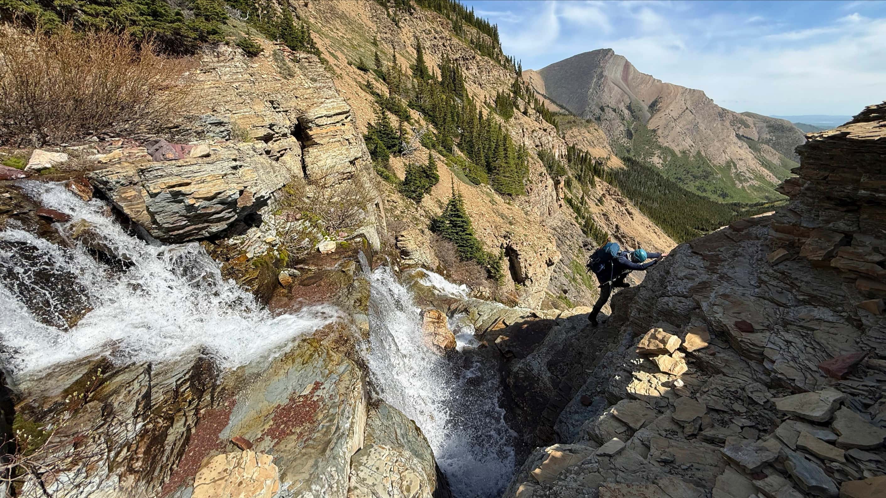
And sure enough, we came to another frozen waterfall, this time with a deep open pool at the bottom.

Mark keeps an eye on where he does – and doesn’t want to go. It’s always fun until someone steps into an anal fissure! 😳

With the sun nearly set, we finally stumble out of the DA and onto the road. For reference, we were inside the DA for 3.5 hours!

The first meeting of the DA survivor’s group. Previously, Andrew was the lone member…

A quick look back before getting out of Dodge.

Part 5 – Into the Sunset: Actually, I think this is away from the sunset, but what Hollywood movie ends with that? 😂

One last look at CJ from the cutline.

All downhill from here.

Arriving back after 21 km over 11 hours and 45 minutes – 6 of which were spent trying to overcome the “Devil’s Playground” and the DA. The route through the trees from the gas road may prove feasible in the summer, but who knows? [insert maniacal laughter] What I do know, is that once you are on open slopes, CJ is an extremely fun scramble. I also know that I’m a blessed individual to have such good friends – guys that would go through hell and back with me. 😉


Leave a Reply