

⚠️ Hiking and scrambling are inherently dangerous activities. Please read my Disclaimer. ⚠️
Whew! This was a LONG day – and not entirely by design. Thankfully, Andrew and I arrived early at the North Kootenay Pass (NKP) trailhead, otherwise much of our return would’ve been under headlamp, as 14 hours would go by before we eventually limped across the finish line. Granted, we were expecting the possibility of a 10 to 12 hour trip depending on where the day’s explorations took us, but when this was combined with a longer than anticipated descent off Mount Borsato, a missed (or missing) trail, and a torn bike tire, the extra hours came into play.
For my second, and Andrew’s third trip to NKP, we wanted to see if we could get up one of the outliers of Centre Mountain. I of course, wanted to try the standalone, Centre E3 which I’ve banally nicknamed, “North Kootenay Mountain”, but as Andrew had ascended it several weeks prior, he proposed an even grander plan: to reach the impressive peak, Centre SE1 – and possibly even Centre Mountain itself. If neither were possible, then the day would be still be a success if we could reach Centre SE1’s unnamed neighbour to the south, a 2468 m summit that I’ve nicknamed, “South Flathead Peak”, because it’s the southernmost point on the Flathead Range. Again, as always, these nicknames are not definitive and function solely for my own reference. If I know of local or Indigenous names, I use them, but if I don’t, I try to make them geographically descriptive.
Thus, after reaching NKP on our bikes, we endured a windy, but uncomplicated ascent along “South Flathead Peak’s” southeast ridge until we found ourselves drawing close to its formidable summit block. As its severity seemed to increase with every step towards it, we began to grow concerned about being able to make the summit, as friable rock and cheese grater slabs forced us to consider the heightened challenge of retreating from any potential route. However, just when it seemed that we would be stymied, we found a convenient scree ramp that led us onto the mountain’s sharpened east face, and from there, a surprisingly clear route to the summit.
At 2468 m, the anvil-shaped “South Flathead Peak” offered impressive views, but the real prize was 2560 m, Centre SE1. However, after venturing towards the col and carefully looking for a route, we failed to see any weakness through the cliffs that guard the mountain’s southern aspect. From the north it looks like it could be a walk up, but definitely not from the south. Moreover, since we couldn’t reach Centre SE1, it also meant that we couldn’t reach Centre Mountain – if a route even exists via the col with SE1.
Undaunted, we noted the gradual slope leading off “South Flathead Peak” and onto the connecting ridge with Mount Borsato, which lies ~2.2 km ‘as the crow flies’ to the west. At this point, we thought exploring the ridge would be fun, followed by a tree line traverse back to NKP. After enjoying lunch on atop a small peak along the ridge, we decided to keep going under the mantra of, “Well, if we’re here…” – which in hindsight, could also double as an epitaph. 😳 Soon forced from the ridge by the imposing cliffs of a peak immediately to the east of Borsato, we traversed the remaining distance across scree and slabs, before eventually finding ourselves on Borsato’s well-guarded east face.
After white-knuckling an unforeseen knife ridge, we found ourselves with two visible options to reach the summit – with the second being the most sane. Exhausted, we stumbled onto the peak where we learned from the summit register, that we were only the fourth party in 10 years to visit this obscure mountain. As time was ticking, we thought we could use the southwest ridge to descend. However, we soon found ourselves beset with cliffs making progress down to the valley, agonizingly slow.
Glad to finally be off the mountain, we thought it would be easy to find the NKP trail and follow it back to where we left our bikes in the Pass, dutifully sucking up the ~4.3 km distance and 530 m elevation gain because, “At least it will be on a trail.” Wrong! We could not find the proper NKP trail despite a thorough search and instead, had little choice but to follow a parallel trail to the base of NKP where without warning, it abruptly ended. Left with little option but to bushwhack our way up the steep slope to the top, we motivated ourselves again by imagining the sweet pull gravity would have on our bikes once we reached the Pass.
However, no sooner had we started back from NKP, when my rear tire brushed a rock that tore the sidewall and ripped the tube. The resulting ‘whoosh’ was both physical and emotional, as I was now forced to walk my bike the remaining ~9 km under fading twilight. While Andrew coasted beside me, graciously offering to share the burden, I reconciled the occurrence to Divine intervention, perhaps preventing me from an unforeseen riding accident, and declined. It was a long hike back, but great company and conversation made it bearable.
Altogether, this trip had the potential to become an epic, but thankfully it did not. I doubt many will have interest in either peak – particularly Borsato – which seems odd for me to say after having it on my ‘To Do’ list for several years – but perhaps I’m talking from fatigue…? Or not. Either way, I’m glad it’s off my list, though conversely, I’m now more intrigued about completing some of Centre Mountain’s other outliers, especially Centre E3 (“North Kootenay Mountain”), which means I will be travelling back to NKP, but this time with a spare tire and tube. 😉
Be sure to read Andrew’s awesome trip report!

Note: My GPS died at the base of NKP on return, hence the gap on the map. To get to North Kootenay Pass, drive south from the hamlet of Beaver Mines along Highway 774 for ~15.5 km until you come to the Lynx Creek (Ohagen Road) turnoff on your right (just past the Beaver Mines Lake turnoff). Turn and follow the Ohagen Road for ~1.8 km until you come to a fork and a sign that says to turn left to reach Lynx Creek. Like a good Canadian, obey the sign and turn left as going straight is now restricted access. Keep going for ~7.7 km until you come to a T-intersection. Turn left and follow the Carbondale River Road for ~2.6 km until the road forks to the right (Lost Creek Road). There is an information sign and a large area to camp just beyond this junction. If you have a high clearance vehicle, drive the remaining ~4 km over an increasingly rough road to the trailhead. We ended up parking ~700 m away from the trailhead but regardless of where you start, I recommend bringing bikes.

Note: My GPS died at the base of NKP on return, hence the gap on the map. From the trailhead, it is ~3.0 km to reach the fork to MacDonald Pass. You will cross four recently constructed bridges in the process. Unless you want to ascend MacDonald Pass, keep going straight along the NKP trail. At the ~3.4 km mark from the trailhead, we came to the first of two, unbridged creek crossings, so be prepared for these. Around the ~5 km mark from the trailhead, we came to the second unbridged crossing (Carbondale River) followed by a ~4.2 km hike n’ bike to reach NKP. In total, it was just under 10 km from the trailhead to NKP with an overall elevation gain of ~605 m.
Ascending “South Flathead Peak” from NKP involved following its southeast ridge up from the Pass for ~1.8 km (~320 m elevation gain) to reach the summit block. Due to cliffs, we then had to lose a bit of elevation as we traversed the mountain’s southern slopes to reach the base of a ramp. Once on the ramp, we followed it up and onto the east face where we regained the southeast ridge and then the summit. In total from NKP, it was ~2.7 km with an elevation gain of ~383 m to reach the summit of “South Flathead Peak”. We determined that we could also descend the same way if we wanted.
The trip from “South Flathead Peak” to Mount Borsato involved following the interesting west ridge long as we could, until we were forced into a side-slope by the cliffs of an intervening peak immediately to the east of Borsato. Though Borsato sits only ~2.2 km ‘as the crow flies’ away, the trip along the ridge took us ~3.1 km to reach its col with the unnamed east peak. From here we scoped out two possible routes up the east face, with the second one being the easiest. However, this involved adding on another ~2 km to reach the summit. In total from “South Flathead Peak”, the trip to Mount Borsato was ~5.2 km with the largest elevation loss being ~290 m.
I should note that due to the large cliffs which guard the base of the east face of Borsato, we were committed to returning the way we came, or descending via the southwest or south ridge. We chose the southwest ridge and it proved tedious with multiple small cliff bands. It was an ~874 m descent over ~4.3 km from the summit to reach Pincher Creek (Flathead version). We then had to hike ~4.8 km while regaining ~530 m in elevation to reach the summit of NKP. From there we returned the way we came.

As my GPS died at the base of NKP on return, I will have to guesstimate more than usual. 😉 Our total distance travelled was ~38 km with total elevation gains ~2109 m. Our total roundtrip time was 14 hours even.

Gearing up in a parking area approximately 700 m from the trailhead. In the background on the left is Mount McCarty and in the centre, Hollebeke Mountain.

The NKP trailhead and the first of four bridges.

Keep smiling McMurray ’cause you ain’t gonna be riding that thing back! 😂 (Photo by Andrew Nugara)

Approximately 3 km from the trailhead, we came to the junction with the MacDonald Pass trail. We would keep going straight to reach NKP.

Arriving at the first unbridged stream crossing which is approximately 3.4 km from the trailhead. (Photo by Andrew Nugara)

Gazing towards Centre E3 or as I call it, “North Kootenay Mountain”.

Just over ~5 km from the trailhead, we came to the second unbridged crossing – this time over the Carbondale River. The trail steepens considerably after this, and we had to push our bikes up much of the remaining ~4.2 km to NKP.

Looking across the valley to Hollebeke Mountain (centre).

Getting our first clear view of “South Flathead Peak” (left) and Centre SE1 (right) as we near NKP.

Donning our hiking boots after stashing our bikes in the trees. “South Flathead Peak” is in the background. (Photo by Andrew Nugara)

Andrew leads the way towards NKP (centre).

Passing the plaque dedicated to Thomas Blakiston.

Gazing up at some interesting rock formations on South Flathead Peak. It looked possible to use the gap in the centre to gain the ridge, but we didn’t try.

Checking out Mount Borsato from NKP. (Photo by Andrew Nugara)

Andrew leads the way onto the slopes of “South Flathead Peak”.

Heading up to the interesting rock formations that we could see from the trail.

Andrew uses a small gully to avoid treadmill scree.

The view back to the summit of NKP.

Andrew hikes past more rock formations after reaching the ridge.

Someone had built a large cairn on the ridge just above the Pass.

On the ridge and following a goat trail towards the summit block.

Framing Centre E3 “North Kootenay Mountain” from the ridge.

Glancing back at our route along the ridge. In the background is Hollebeke Mountain. (Photo by Andrew Nugara)

Another view of Centre E3 and the NKP trail.

Andrew leans into an increasingly steep slope.

At the base of the summit block and pondering our options. The crappy rock and steep slabs made us cautious to try anything that could be difficult to down-climb.

From this angle, we couldn’t see the ramp that runs across the centre of the photo. It just looked like a giant cliff.

Unable to find a sane route along the southeast ridge, we began to traverse further to the west with the hope of finding a route.

Anyone see a white rabbit? 😉

Heading up the ramp that was invisible from below. (Photo by Andrew Nugara)

Looking back at Andrew.

The ramp emerged onto a narrow ledge located on the east face of the mountain.

Snapping a photo of our primary objective, Centre SE1. (Photo by Andrew Nugara)

Gazing back along the ledge as Andrew checks out the route to the summit.

After negotiating some small slabs near the beginning, following the ridge to the summit (right) did not prove to be complicated.

Andrew skillfully leads us towards the summit.

Almost there…

Arriving on the summit of “South Flathead Peak” (2468 m).

A pano to the north. (Photo by Andrew Nugara)
Centre Mountain (left) and Centre SE1 from the summit.

A telephoto of Centre Mountain.

A telephoto of Centre SE1.

I will be coming back to venture up Centre E3 “North Kootenay Mountain” when I get the chance! Edit: Done!

Gazing to the southeast at Mount McCarty (left) and Hollebeke Mountain (right).

A telephoto of Mount McCarty.

A closer look at Hollebeke Mountain.

The view south towards Packhorse Peak (left of centre).

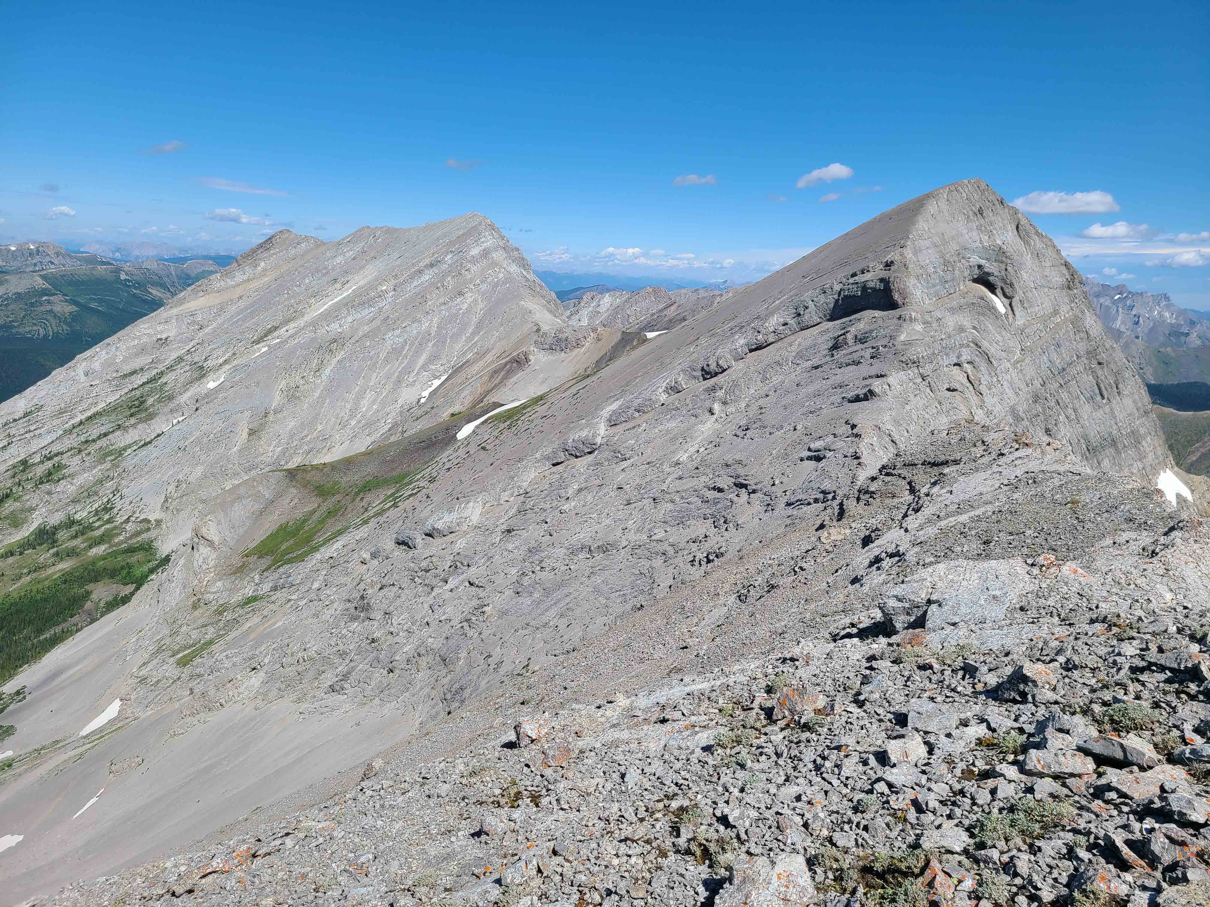
Looking west along the connecting ridge with Mount Borsato, while on the right is Mount Corrigan.

A telephoto of Barnes Peak.

I built a small cairn and named it, Horace. (Photo by Andrew Nugara)

Andrew and Horace.

Andrew heads towards the col with Centre SE1 to check for a possible route.

At 2560 m, Centre SE1 is an impressive peak!

Andrew (lower centre) begins to head down to the col as he looks for a possible route.

Andrew’s view back to me. (Photo by Andrew Nugara)

Though he discovered that it was possible to reach the col by continuing along the ridge, neither Andrew from his vantage, or I, could see any way to get beyond the cliff wall that guards an approach from the south. If we lost a ton of elevation, it might be possible to circumvent them, but we weren’t keen on taking the chance and failing. There may be a hidden way through the cliffs, but the approach from the north seemed much easier – that is, if you can get onto the ridge in that location… Sounds like another trip! 😁

Though stymied by our primary objective – but satisfied with tagging a new summit – we decided to explore the connecting ridge with Mount Borsato. Click to continue on to Mount Borsato.


Leave a Reply