
⚠️ Hiking and scrambling are inherently dangerous activities. Please read my Disclaimer. ⚠️
Preamble regarding hiking and the new COVID-19 restrictions: After carefully examining the Government’s new public health measures, I noticed that outdoor physical activities are still allowed, provided they involve less than 10 people and physical distancing is maintained throughout. Though the government strongly recommends participants come from the same household, it does not prohibit outside involvement. As I take COVID seriously and do not want to violate any rules or more importantly, unintentionally spread the virus, I’m glad that it’s still possible to head to the mountains (in separate vehicles) and hike at a distance with others.
Happy New Year! This uneventful trip was a great way to cap off an eventful 2020 – a year that began with cancer surgery and ended under the shadow of COVID-19. As weird as it was, 2020 also saw two of our kids become engaged to wonderful partners while our married son and his wife purchased their first home. Hmmm… somehow Melanie and I grew old as well… well I did, Melanie never ages! 😊 Even though we couldn’t gather as a family over Christmas, we made do with Zoom visits and online group games.
As I’ve mentioned like a broken record (an old reference from an old man), the small foothills are my jam in the winter months and I love exploring them on snowshoes. Today’s trip combined two repeat destinations – “Screwdriver Ridge” and Mount Backus – using two new approach routes to make a loop.
Since Andrew had never visited “Screwdriver Ridge” and we were looking for something to avoid potentially inclement weather, we decided to try a route from the southeast. Avoiding lovely, “Blue Mountain” as part of the trip was tough for us, but the trip up Screwdriver’s southeast slopes was straightforward and quick. It was so quick in fact, that we reached the top in only 1 hour and 8 minutes.
Wanting to extend the trip a bit more, we decided to explore the south ridge of “Screwdriver” on our descent. As we made our way down, we began to wonder about a backdoor route up nearby, Mount Backus. After making it onto the road, we decided to give Backus a shot and ended up finding a great trail that took us onto the connecting ridge. From the ridge, we then slogged our way through deep snow and up steep slopes to the summit. I highly doubt anyone will want to try this route, but it did make for a nice loop and added one more summit onto 2020.
Anyway, thanks for reading and may every summit in 2021 bring you gratitude, wonder, and awe. Peace. 😊
Be sure to read Andrew’s excellent trip report!

To get to “Screwdriver Ridge” and Mount Backus, we drove west from Pincher Creek on Highway 507 to the hamlet of Beaver Mines. At the T-intersection on the edge of town, we turned right (north) and continued on Highway 507 for ~1.1 km until we came to Township Road 6-2A. We then turned left (west) and followed the gravel road for ~3.8 km until we came to a locked seasonal gate. Here, we parked on the side of the road as this was our starting point.
From the gate we hiked along the road for ~1.3 km until we came to a cutline and could see the open slopes of “Screwdriver Ridge” on our right. Please note: that for the first ~900 m after starting from the gate, the land on either side of the road is private. The accessible public grazing lease does not start until you cross over the cattle guard ~900 m from the gate. While “Blue Mountain” is especially tempting to try from this section, don’t do it.
From the road, it was a straightforward ~2 km trip (270 m elevation gain) through the trees and up the slope to the summit. We had to cross a fence which we did by easily belly-crawling under it. Fences are important and so I always try to find a spot to cross where I don’t have to touch it to prevent damaging it – or me. An alternate for “Screwdriver” begins through the gate at the cattle guard on the road, this way the fence doesn’t have to be crossed. From the summit, we descended the south ridge for ~2.4 km to reach the road near the gas plant. Note that we had to cross a fence to reach the road.
The trail to reach the west ridge of Mount Backus begins behind the gas plant and we followed it for ~1 km to the top of the small ridge. We then made our way east and towards Mount Backus along the ridge. After a few hundred metres, we reached the mountain and the ~1.2 km (211 m elevation gain) snowshoe to the summit of Backus was steep from this point on, especially near the top. However, we made it down from the summit and back to the trail ~ 20 minutes, so there is this advantage to our route.
Once back at the gas plant, it was an easy ~3 km hike back to our vehicles along the road.

Our total roundtrip distance was 14.8 km with total elevation gains of 807 m. Our total time came in at 5 hours and 13 minutes. For reference, it took us 1 hour and 8 minutes over ~3.5 km to reach the summit of “Screwdriver Ridge” from our vehicles. The elevation gain over this distance was 300 m.

Our starting point at the seasonal gate on Township Road 6-2A.

Making the easy trip along the road. Note that for the first ~900 m, until you cross a cattle guard, the land on either side of the road is private property. Though it looks tempting to ascend “Blue Mountain” from here, don’t. “Screwdriver Ridge” is directly in front of Andrew.

After hiking the road for ~1.3 km, we came to a cutline that presented a straight line to the summit.

From the road to the summit it was an easy ~2 km hike.

Making our way through a patch of aspen. (Photo by Andrew Nugara)

Emerging onto open slopes. The small ridge in the background sits above the hamlet of Beaver Mines and is on private land.

Coming to a fence. (Photo by Andrew Nugara)

Though we hadn’t decided yet, Mount Backus (right) would become our next destination for the day.

Andrew scurries under the fence.

Approaching the upper slopes.

Another look back reveals Prairie Bluff (left) in the distance.

I thought this old branch looked like a bird.

This tree had fallen and over time, it had become buried. In the background is “Blue Mountain”. (Photo by Andrew Nugara)

A quick deviation into the trees where I discovered that someone else had recently snowshoed to the top. Though we had our snowshoes, we did not really need them until we decided to tag Mount Backus. (Photo by Andrew Nugara)

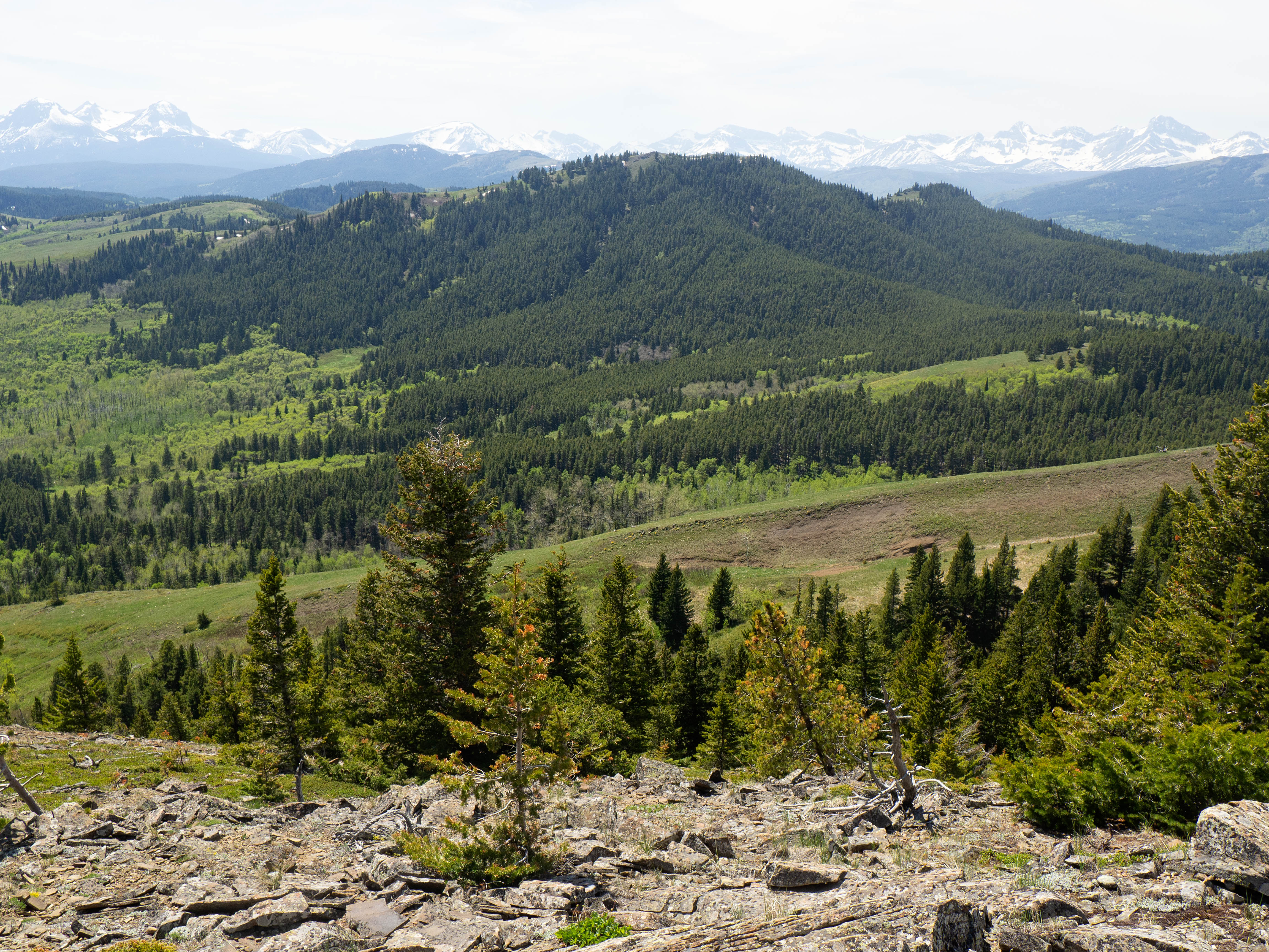
It’s too bad that it was so cloudy because the views from this little foothill are pretty good.

A closer look at “Carbondale Ridge” (centre) and Carbondale Hill (left).

Getting close to the top…

Followed – but not too closely – by Andrew.

My second time this year on the summit of “Screwdriver Ridge” (1691 m).

My favourite little foothill, “Blue Mountain”, sits ~3.5 km hiking-wise to the east. Back in May, Brad and I enjoyed a fun loop of Blue and Screwdriver.

A telephoto to the southeast of Prairie Bluff (centre) and Mount Albert (left).

Gazing across the valley and to the north at Burmis Mountain.

Describing the route Brad and I took in May. (Photo by Andrew Nugara)

Heading to the second bump. The summit of “Screwdriver” is quite expansive and is characterized by three small bumps. The first two are of equal height, while the third is slightly lower.

Andrew checks out some impressive drifts.

‘Karen’ the cairn is still standing, though to be fair, I just made her last May.

Looking back to the first bump.

Gazing to the southwest from the second bump. Unfortunately, Southfork Mountain (left) and Syncline Mountain (centre) are beclouded. In the foreground on the right is “Carbondale Ridge”.

The view to the northwest and the third bump.

What ‘drifting’ means to a hiker. 😂

Arriving on the third bump. (Photo by Andrew Nugara)

Andrew arrives on the third bump.

Immediately across the valley to the northwest sits Maverick Hill (centre) and Poker Peak (right).

Byron Hill (centre) was a great snowshoe.

Another look at Burmis Mountain, (right of centre) which was another great snowshoe, but required access permission from three different leaseholders.

To the south sits our next destination of the day, Mount Backus. The south ridge in the foreground is what we descended to reach Backus.

A quick look at the end of “Screwdriver Ridge”. I nicknamed the ridge after nearby, Screwdriver Creek.

Why and how Ginger Hill (foreground centre) has a name is a mystery to me. I’m not complaining, but it seems quite random. Perhaps an episode of Gilligan’s Island was filmed there? 😉

Snapping a few pics before heading to Backus. (Photo by Andrew Nugara)

Andrew checks out the views again from the first bump.

A colourful rock backdropped by a cool lenticular cloud. (Photo by Andrew Nugara)

Andrew leads the way as we head towards Mount Backus, which from here, is ~5.9 hiking kilometres away. Click to continue towards Mount Backus.


Leave a Reply