

⚠️ Hiking and scrambling are inherently dangerous activities. Please read my Disclaimer. ⚠️
The ‘Where Should I Go Hiking?’ folder that I figuratively keep in my brain is roughly divided into two lists: one for potential summer destinations and one for potential winter destinations. This folder should not be confused with the ‘Go Take a Hike!’ folder that I also figuratively keep in my brain, which coincidently is also divided into two lists – but we won’t get into that here. I will say however, that Carbondale Hill has been on my winter hiking list for a while now, especially after my solo attempt last February was thwarted by thick deadfall covered in deep snow (yes, I will actually admit that I once failed to summit this little guy). So with revenge on my mind 😉 , I dropped the kids off at nearby Castle Mountain to ski while I set off to conquer the ‘mighty’ summit of Carbondale Hill. Only this time, I was joined by my nephew, Jeff, who hadn’t been able to get out hiking since we climbed Thrift Peak together in September.
According to the second edition of Mike Potter’s, Fire Lookout Hikes in the Canadian Rockies (an awesome Christmas gift that I received this year from my awesome wife, Melanie), there has been a fire lookout on top of Carbondale Hill since 1928. The current structure is the third lookout design to sit on the summit and was opened in 1982. To me, it looks very similar to the design of the fire lookout on top of Hailstone Butte. Mike Potter also notes that Carbondale Hill is “the most southerly active lookout in Alberta.”
I love hiking to fire lookouts because you are generally rewarded with impressive panoramic views and Carbondale Hill is no exception, as it offers a fine overview of the Castle Crown Wilderness Region. Hiking up Carbondale in the summer would be a good outing if you had small kids or are looking for an easy and quick destination with a view. The other nice thing about fire lookouts is that there is always a road to walk on if off-trail is not your cup of tea. For me, Carbondale Hill fit the bill for a quick winter off-trail hike.

Carbondale Hill is easy to get to, but requires some additional walking in the winter as the section of Castle River Falls Road past Ohagen Road is closed from December 15 until May 1st. We parked at the access gate and hiked up the road a short distance to where a shallow gully appears on the lefthand side of the road. Here is where we left the road and our route simply followed the bare slopes and sparsely wooded sections to the top. I learned from my February 2013 attempt to avoid gaining the first bare slope that you come to beacuse you will only have to lose it again. Instead, we stayed in the trees and bypassed it to the left (see image above). When we eventually came to a cutline, we turned north and followed it a short distance until we bisected the fire lookout’s access road. We then continued up the main slopes until we reached the summit. We returned the same way except when we came to the cutline, we decided to avoid re-trekking through deep snow and so we hopped onto the fire road and followed it out to its junction with the Castle Falls Road. This meant that we emerged further north from our vehicle than our original entry point, but it was an easy walk back along the wind swept, icy road. Overall, Carbondale Hill is a very easy hike and if it weren’t for the blasting chinook winds on the summit, it would have been a fantastic day.
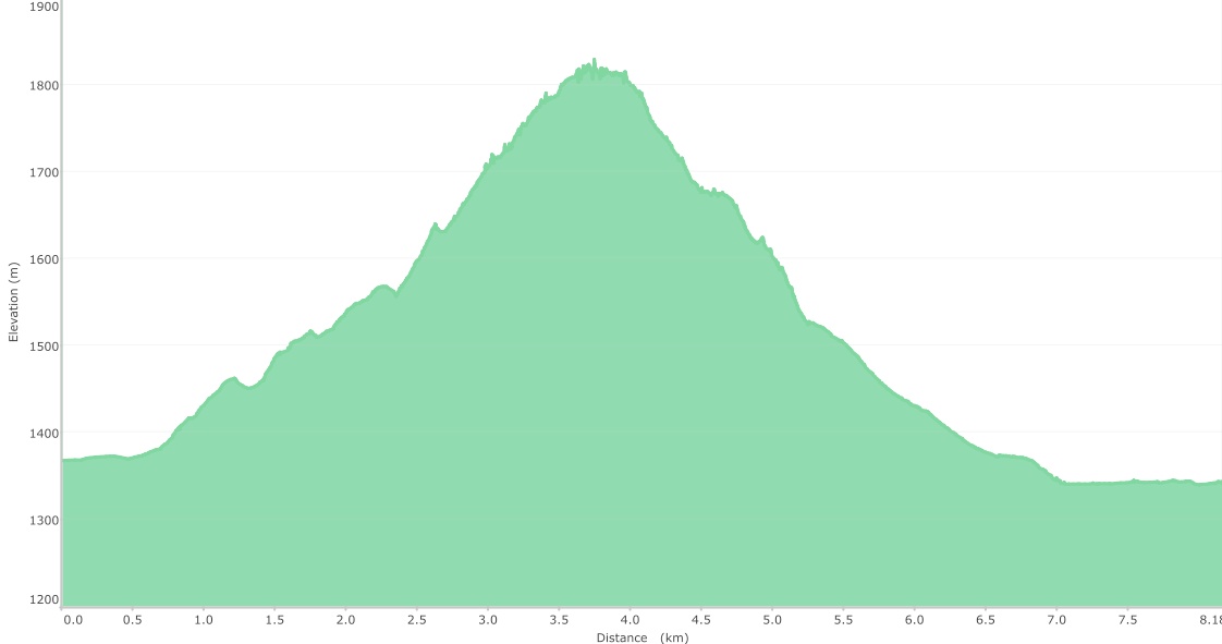
Carbondale is a quick and fun winter destination with under 4km of hiking required to reach the summit. If off-trail trekking through knee-deep snow is not your cup of tea, bring a pair of snowshoes or hike, ski, or snowshoe up the fire lookout’s access road. Our total hiking distance was 8.2 km with a total elevation gain of 514 m. Our round-trip hiking time was just over 3.5 hours.

Shortly after leaving the Castle River Falls Road, Jeff and I encountered knee-deep snow. The shallow gully we followed can be seen behind Jeff.

The shallow gully soon turns into a fairly steep gorge. We stayed to the climber’s right and not long after coming to this scene, you will encounter your first open slope where you can gain elevation. Unless you want the exercise, resist the temptation to leave the trees and climb the slope because you will only lose the elevation again. Instead, skirt the slope through the trees to the climber’s left.

The view to the southeast from the first section of open slope that we climbed. Table Mountain is on the left, Whistler Mountain is in the centre, and Southfork Mountain is on the right. Unfortunately, cloudy chinook skies obscured our views.

Typical travel through the trees. I’ve always loved the feeling of walking through the forest in the winter. (Photo by Jeff Lang)

We encountered the deepest snow of the day while connecting to Carbondale’s main ascent slopes via the cutline. In case you are wondering, I actually do own a pair of snowshoes… oh, and the ice axe is purely for defensive combat only because you never know if you will run into John Lithgow/ Sly Stallone, Cliffhanger situation in the mountains. In this picture, I’m walking across a creek on a fallen log. What you can’t see is that the creek is actually about 1.5m below me, so falling wasn’t an option. (Photo by Jeff Lang)

Looking up the fire road from where we bisected it along the cutline. To avoid re-trekking through the really deep sections of snow on our descent, we would follow the fire access road from close to this point down to the Castle River Falls Road.

The view to the southeast from higher up on the main slopes. The first peak of Syncline Mountain is on the far right and Castle Mountain Ski Resort (Gravenstafel Ridge and Mount Haig) is barely visible immediately to the left of Syncline.

Some blue sky emerges as we hike up the final section to the summit. From this point on, the wind began to rip and we had to layer up and put on the face gear.

Some impressive cornices adorn the final section before the top.

Jeff fights the strong crosswind as he makes his way up Carbandale’s upper slopes. Behind him is Table Mountain (left) and Whistler Mountain (right). In fact, the area to the right of Table Mountain is a fun, multi-destination route that we call, ‘The Whistler Loop‘.

We still had some deep drifts to overcome before reaching the summit. (Photo by Jeff Lang)
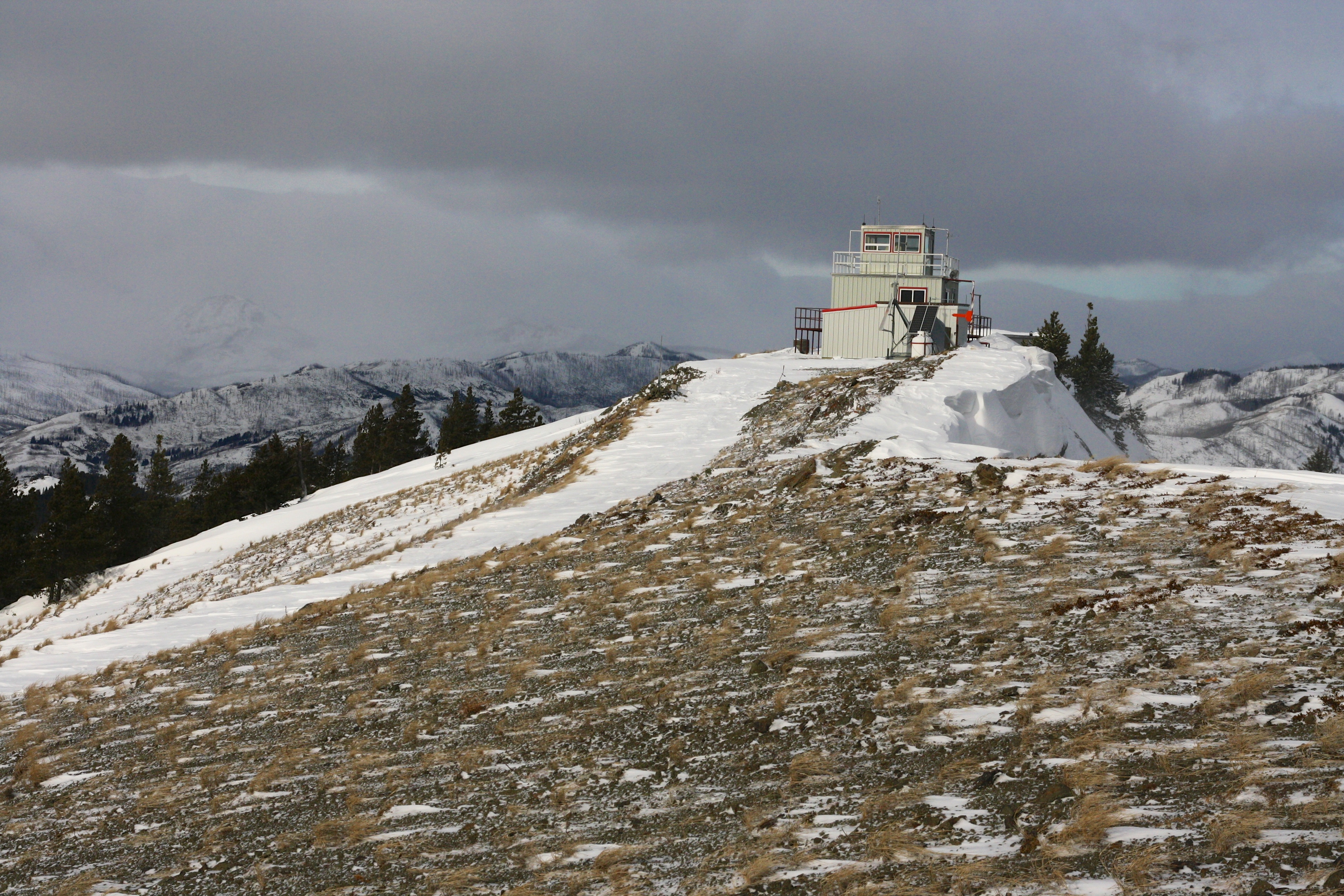
The fire lookout on the summit of Carbondale Hill comes into view. To see the video of this scene, click here.

“The sea wind was angry that day, my friend.” – George Costanza, Seinfeld. At this point we were simply looking forward to taking shelter behind the lookout. The disadvantage of hiking to lookouts in the off season is that no one is there to offer you a hot cup of coffee…

Looking south from the fire lookout. The flying snow blasted the camera lens and obscured the view of all three peaks of Syncline Mountain. You can still enjoy the rolling hills in the foreground though.

Jeff stands on the Carbondale Fire Lookout.

I don’t think anyone is going to access this shed until the spring… though it does look like someone was able to harvest a good crop of rocks.

Jeff hunkers down for a quick lunch on the sheltered side of the fire lookout. Even on this side of the structure, the spindrift of snow was pretty intense at times (see below).

Looking east toward our ascent route from the sheltered side of the lookout. The graininess is not the result of a high ISO setting on the camera, but is actually the spindrift from the wind.

That’s me braving the wind and standing on the lookout. (Photo by Jeff Lang)

Terrorists have taken the lookout! (Photo by Jeff Lang)

Looking northeast from the lookout. Hillcrest Mountain and Turtle Mountain are the tallest peaks on the distant left. Maverick Hill, Poker Peak, and Ginger Hill are visible in the middle ground just above the pipe on the shed roof. The South Peak of Livingstone Range can be seen in the centre along with Robertson Peak, Tallon Peak, Byron Hill, and Burmis Mountain. Just squint and you might see them all! 😉

Looking southeast towards Whistler Mountain and the abandoned Whistler Fire Lookout from the second storey of the Carbondale Fire Lookout.

Another view to the north from the lookout. The helicopter pad is partially covered in a snow drift. I think the orange windsock says all that needs to be said about the wind. Clubs Peak and Spades Peak on Hastings Ridge are to the left of centre.

A cool shot that Jeff took of a dead tree on our way down. I’m particularly impressed that he was also able to capture the green orb-shaped UFO that had been stalking us throughout the day. 😉 (Photo by Jeff Lang)

All day long we found lots of kitty tracks. Here a momma kitty and her cub left some nice tracks in the snow. ‘Soft kitty, warm kitty, little ball of fur. Happy kitty, sleepy kitty, Purr, purr, pur-r-r.’ – Penny to Sheldon on The Big Bang Theory.

Hiking out along the fire lookout’s access road. If you want an easy hike to do in the summer with kids or don’t feel like trekking off-trail through the snow in the winter, you could readily ski, hike, or snowshoe up the road to the summit via the access road.

It would appear that someone else had also decided that the fire road would be a good place to descend from Carbondale. This particular cougar left the largest cat tracks that we found all day. Since it had snowed the night before, these were fairly fresh.

We followed the cougar’s tracks almost all the way back to the Castle Falls Road. Eventually his tracks would leave the road in pursuit of some fresh, and suddenly hasty deer tracks.

The gate to Carbondale Hill fire access road along the Castle River Falls Road. By now, moose tracks have replaced the cat tracks along the road.

The view down the closed section of the Castle River Falls Road as we hike back to our vehicle.

One last look at Carbondale Hill from our vehicle. The bare slope in the foreground is what you should avoid if you follow our route. Stay to the left of it unless you want to gain the elevation for exercise, but know that you will have to lose it all again. Oh, and I have successfully referenced two television sitcoms and one motion picture within this blog. That’s “pretty, pretty, pretty good,” according to Larry David of Curb Your Enthusiasm.


Leave a Reply