

⚠️ Hiking and scrambling are inherently dangerous activities. Please read my Disclaimer. ⚠️
It was one year ago today that I was diagnosed with papillary carcinoma thyroid cancer. A week before, I underwent a fine needle biopsy and during the procedure, I could tell from the conversation between the radiologist and the lab technicians, that the nodule growing from my thyroid was not benign. I may not be trained in medicine, but descriptors such as “chunky” and “calcified” are generally not good when discussing cells and tissue. In fact, I’m not sure of a conversation where they would refer to something positive – save for perhaps a Chunky Kit Kat, but then again, I’m not sure I’d want to eat a Calcified Chunky Kit Kat. 😳
After my doctor shared the diagnosis with Melanie and I, the two of us went to Starbucks to process things before returning to work for the afternoon. Later that evening, we had our adult kids over to share the news firsthand – while surreally, pausing every few moments to hand out candy (maybe even some Chunky Kit Kats) to trick or treaters at our front door. Given all that has transpired in 2020 with COVID-19, it seems like this moment in time is much further removed than simply a year. Coincidently, it was thirty-seven years ago today that my father succumbed to esophageal cancer, though ultimately, it was because of his cancer that I was able to discover my own, but that’s another story for another day. Needless to say, Halloween has twice proven to be a pivotal day in my life.
Thus, being on a mountain today was extra special. When Andrew asked me for destination ideas earlier this week, I suggested Mount Yarrow because it was the only peak on the front range of the Castle that I had yet to tag. Back in 2013, when Jeff and I ascended nearby, Spread Eagle Mountain, we decided to forego the ridge walk to Yarrow and I’ve regretted that decision ever since. However, it wasn’t until I returned to Lethbridge this afternoon, that I remembered that yarrow (the plant) is traditionally associated with the healing of wounds, so in hindsight, missing out on it in 2013 allowed it to become a highly symbolic choice for today. Funny how things like that happen.
A far more practical reason for choosing Yarrow was the weather. An overall nasty October, had left a significant amount of snow in the mountains and we surmised that the warm, but windy weather over the past few days might have cleared off Andrew’s 2011 route up the southwest slope of Yarrow. To our delight it had – or at least a modified version of the route, as ice and lingering snow all but ruled out any scrambling. Fortunately, we were able to ascend alongside a large drainage where the only difficulty was post-holing for ~250 m through knee-deep snow. Even though an intense and frigid wind shortened our summit stay, we were treated to some great views, and I, some great company. 😊

To get to Mount Yarrow from Lethbridge, drive west on Highway 3 to Pincher Creek. Then take Highway 6 south for ~27 km until you come to the Twin Butte General Store. Continue south on Highway 6 from the entrance of the store for another ~4.2 km until you come to the junction with Township Road 34. Turn right and onto Township Road 34 and drive west for ~8.2 km until you come to a T-intersection with Range Road 303. Turn left and proceed for another ~1.3 km until the road ends. This is the trailhead.
The field immediately to the west of Range Road 303 is private and is demarcated by an electric fence marked with numerous, ‘No Trespassing’ signs. The newly signed trail leaves the parking area and follows alongside the electric fence for ~300 m towards an obvious cutline. You then cross through an open gate and onto the cutline.
The trail continues along the cutline for several kilometres as it parallels “Yarrow Ridge” until it eventually merges with a road just prior to a large gas plant. Approximately 80 m beyond the gas plant, you will come to a junction on the road. Keep straight and follow the road for another ~2 km until it ends at a pumping station. From our vehicle, it was a total of ~5.6 km to this point.
The trail continues into the trees behind the pumping station (look for a small cairn). Follow it for another ~420 m (~6.2 km from the trailhead) until you come to a very obvious drainage (and wash) that intersects the trail. From here follow the drainage to the northeast and towards Mount Yarrow. Depending on the conditions, you could probably follow the drainage all the way to the mountain and then scramble your way up.
However, due to snow and ice, we chose to avoid scrambling and follow alongside it to climber’s left. This treed ridge leads onto the southwest slopes of Yarrow where two small, but easy cliff bands present the only obstacles – unless of course there is knee-deep snow within the trees. 😉 Once on the ridge, it is a short hike and then an easy scramble to reach the summit of Mount Yarrow. In total, it was ~3.2 km from the trail to the summit with an elevation gain of ~664 m. After enjoying the views, we returned the same way, though if you want, you could continue on to the much higher summit of Spread Eagle Mountain.

Our total roundtrip distance was 18.4 km with total elevation gains of 1078 m. Our total roundtrip time came in exactly at 6 hours and 30 minutes.

Gearing up at the Yarrow Creek trailhead. The summit of Mount Yarrow can be seen on the far right with “Yarrow Ridge” in the foreground. As it is hunting season, the parking lot was quite busy and we ran into several hunters along the trail. This conservation officer’s truck was here all day and I’m assuming that she / he was checking in on hunters somewhere in the backcountry.

Following alongside the electric fence.

These signs were not here a year ago. However, I found it strange that there were no other signs outside of the trailhead and here, especially since the trail will eventually merge with a road and then continue beyond its terminus.

Mount Dungarvan is front and centre as we enjoy easy hiking along the cutline.

Receiving our first good views of Cloudy Ridge Junior (right) and Cloudy Ridge (far right).

A lone hunter on horseback (centre left) scouts for sheep on “Yarrow Ridge”.

Drawing closer to the hunter and his horse.

There are multiple ways to ascend “Yarrow Ridge” including some interesting scrambling routes.

Early morning sunlight illuminates the south and eastern ends of the mountain.

Are we ascending Mount Yarrow or Mount Doom? 😂

An intriguing red argillite drainage on the south side of Yarrow. This could prove to be an interesting route onto “Yarrow Ridge”… 🤔

A bike would definitely be nice for this section of the approach… A reminder that only the section of the road near the gas plant is on public land. The rest of it, including the entrance off of Range Road 303, is all on private land and is off limits to hikers. A bike however, could still be used on the cutline trail, though there would be some pushing in places.

Our first view of the summit – the square block to the left of centre – since the trailhead. Trying to reach it from “Yarrow Ridge” involves a 5.8 technical ascent.

Andrew inspects an outlier of Mount Glendowan (left) for possible ascent routes. The pumping station at the end of the road is in front of him.

Arriving at the end of the road.

The view up Yarrow from the end of the road. This is where Andrew ascended in 2011, but after seeing snow and ice along his route, we opted to keep heading towards a drainage located further down the trail.

The trail continues into the forest from the end of the road. After seeing the new signs that were placed at the trailhead, I’m surprised there was not one here. Only a small cairn marked its continuation.

After spending so much time on the road, the trail was a welcome change of scenery.

Approximately 420 m from the end of the road and ~6.2 km from the trailhead, we came to where a very obvious drainage intersects with the trail.

Heading up the drainage shortly after leaving the trail.

Travel along the lower section of the drainage was relatively easy, though on the way back, we avoided it by sticking to the forest.

One of many interesting rocks we came across.

This would be extremely colourful under better light.

The view back and towards “Cloudowan Peak” (left of centre). I definitely need to start knocking off more front range peaks in Waterton! 😊

From this vantage, we could see that any attempt to scramble up Yarrow along the drainage was futile due to snow. However, the left side of the drainage and subsequent route through the trees looked doable. Hence, this is where we left the drainage to gain the small ridge on the left.

The small ridge gained elevation quickly and we would eventually emerge onto the clearing directly above Andrew. We could also now see the summit (centre).

The opposite side of the drainage could prove to be an interesting ascent when conditions are dry and clear – but not today!

After a short stint of moderate bushwhacking along the ridge, we emerged onto a clearing and the base of a rock band.

The southwest slope of Mount Yarrow is steeper than it looks!

The small rock band was covered in ice and snow. (Photo by Andrew Nugara)

This is why we chose not to attempt any serious scrambling.

Fortunately, there were clear paths through the rock and very little hands-on effort was required. (Photo by Andrew Nugara)

The view west and up Yarrow Creek trail from above the rock band.

The view south and towards Cloudy Ridge (left), “Cloudowan”, and Mount Glendowan (right of centre).

Above the first rock band and settling into an energy-sucking ~250 m post-holing adventure. 😑

The steep grade coupled with deep snow made for slow progress.

A brief foray onto wind-swept terrain.

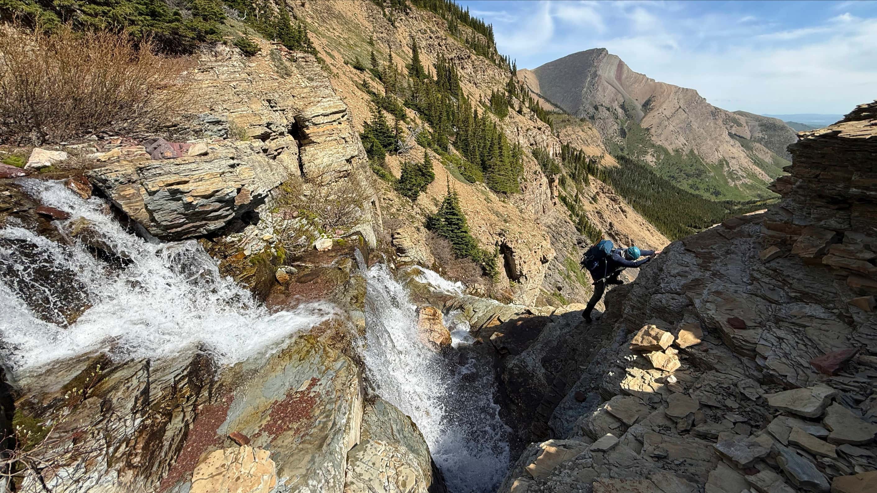
A second rock band marked the end of our knee-deep adventure through the trees. (Photo by Andrew Nugara)

I carefully make my way up. (Photo by Andrew Nugara)

“We come from the land of ice and snow, from the midnight sun where the hot springs flow.” – Led Zepplin, The Immigrant Song. (Photo by Andrew “Page” Nugara)

Andrew follows close behind.

The view towards Spionkop Ridge from above the second rock band.

The end of the snow and the beginning of an unsheltered slog to the summit ridge. (Photo by Andrew Nugara)

Andrew leads the way as we are battered by an intense and frigid wind.

Drawing closer to the summit.

Finally on the ridge with the summit close at hand.

Looking towards the summit of Spread Eagle Mountain from the ridge. (Photo by Andrew Nugara)

It may look somewhat involved, but it’s an easy scramble to reach the summit.

Gazing back to Andrew as I near the summit.

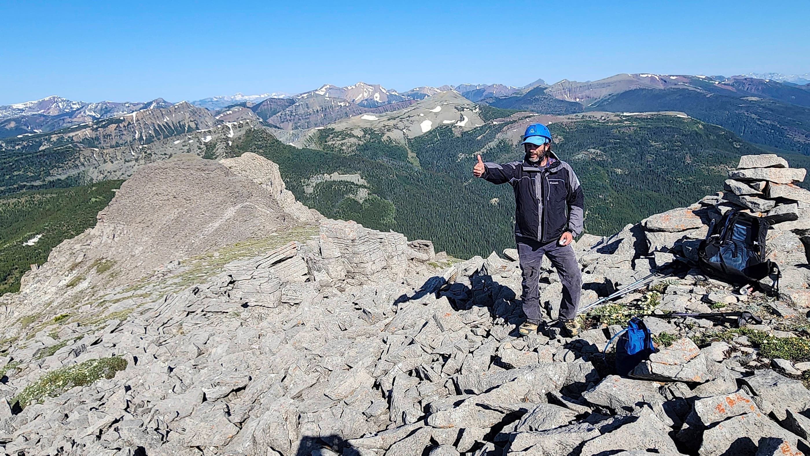
A small cairn marks the summit of Mount Yarrow (2320 m).

A windy pano to the southeast…

Followed by a pano to the south. Gotta love that oval sun! 😂

A pano to the west…

And another to the northwest.

Gazing north towards the fun winter destinations of “Raptor Peak” and “The Eaglet”.

The view to the northeast and onto “Yarrow Ridge”.

A telephoto reveals a number of cars at the trailhead (centre).

The jagged east end of Mount Yarrow. As I mentioned before, reaching the summit of Yarrow from the ridge involves a technical ascent.

The view south includes (from left to right): Mount Dungarvan, Cloudy Junior, Cloudy Ridge, Piinaquiium / Ahkoinimahstakoo (Mount Blakiston), and “Cloudowan Peak”.

The view towards Mount Glendowan (centre).

A telephoto to the west of a snowbound, “Newman Senior” with Newman Peak on the right.

A closer look at Spionkop Ridge (left).

Loaf Mountain pokes above Spionkop Ridge.

Finally, a good look at Spread Eagle Mountain.

Even though you can’t see it, you know that Andrew’s sporting his summit smile. 😊

Frozen like a popsicle! (Photo by Andrew Nugara)

And for good measure – and just before my fingers went completely numb from the cold – one last view of Spionkop Ridge and the Yarrow Creek trail.

The wind and freezing temperatures limited our summit stay to less than 10 minutes.

A quick glance back to the summit. (Photo by Andrew Nugara)

A momentary pause as we contemplate continuing on to Spread Eagle Mountain… (Photo by Andrew Nugara)

However, the biting wind quelled any remaining enthusiasm, and so we descended the way we came.

Andrew negotiates a ‘luge track’ on the second rock band.

To quote The Immigrant Song again …”Valhalla, I am coming.” 😂 (Photo by Andrew Nugara)

Thanks to our earlier post-holing efforts, our descent through the trees was fairly quick.

Navigating the upper section of the first rock band.

Much of the ice had melted, but we still had to be careful with our footing.

At the base of the first rock band and the start of easier terrain.

Gazing down the drainage. We would stay to skier’s right all the way back to the trail.

Glad to be out the wind, we enjoyed the view as we made out way down.

Some sections required bushwhacking, but thankfully, anything moderate and above did not last long.

Back on the Yarrow Creek trail.

Gazing at Mount Yarrow from the pumping station at the end of the road.

The cairn that marks the continuation of the trail. (Photo by Andrew Nugara)

Wishing again that we had bikes…

Andrew pauses for one last look at the summit (left of centre).

That intriguing red argillite gully under afternoon sunlight. This would definitely be cool to explore one day.

The first of three hunters that we would meet on the way back.

Heading towards the cutline. We would end up chatting with a friendly hunter who was sitting beside the trail shortly after this photo was taken.

Ugh. Gaining elevation on the cutline was not fun.

Finally on the home stretch.

A third hunter passes us near the start of the cutline.

Looking towards “Yarrow Ridge” (left), Mount Yarrow (left of centre), and Spread Eagle Mountain (right) from the trailhead.

Spindrift on the summit of Mount Yarrow shows why we didn’t linger long.

Arriving back at the trailhead after 6 hours and 30 minutes over a total distance of 18.4 km. Today’s trip was special because it occurred on the anniversary of two pivotal moments in my life. Having the privilege to reflect on this while immersed in Creation was both healing and motivating. Peace.

Leave a Reply