
⚠️ Hiking and scrambling are inherently dangerous activities. Please read my Disclaimer. ⚠️
Southfork Mountain is a bit of an oddity and if it didn’t already have an official name, I’m not sure anyone would really take notice of it. Outside of being located at the northern end of Barnaby Ridge, its stature is muted compared to two other high points along the ridge. In fact, the second highest point on Barnaby Ridge is located only ~1.5 km to the south and is a very noticeable ~70 m higher. Yet oddly, it doesn’t have an official name though the Castle Mountain folks affectionately call it ‘The Amoeba’. It’s as if in the mountain naming Olympics, ‘The Amoeba’ was caught using PEDs and was stripped of its name which was then given to the bronze medalist. Maybe it should be called ‘Ben Johnson Peak’ or ‘Lance Armstrong Peak’?
So, why does Southfork Mountain have an official name? From what I can gather, it’s related to the original name for the Castle River which was the “South Fork of the Oldman River” and then later, the “South Fork River”. That the confluence of the West Castle River and the South Castle River occurs directly to the north of Barnaby Ridge and can be overlooked from Southfork Mountain, also plays into this.
Now that I’ve made Southfork Mountain seem like an altogether unappealing destination, I have to qualify things by saying how much fun we had. It was a fabulous way to spend a windy, but beautiful fall day. The hike up to the Southfork Lakes was scenic and the ascent from the lakes to the summit was uncomplicated. The views from Southfork and from along the entire ~3.5 km traverse over to the summit of Barnaby Ridge were excellent while the low angle of the fall sun, further accentuated the colours of the rock. The only drawback to the day was the wind which in a few places, made it difficult to maintain our balance, but what else is new in southwestern Alberta? The only two changes that I would make on a return trip would be to bring my 4wt fly rod and park a pair of bikes or another vehicle at Castle Mountain to avoid the long return walk. Otherwise, it was a great day!

Driving along Highway 774 towards Castle Mountain Ski Resort, I took the first lefthand turnoff that I came to once I reached Syncline Mountain. It was a bit of a rough road, but we soon came to a large open meadow next to the West Castle River. In hindsight, I probably should have taken the second lefthand turn which leads to the University of Lethbridge research station, but in reality, the parking area I chose and the research station are only a few hundred metres apart and connected by a rough trail along the riverbank. In, Hiking the Southern Rockies, Joey Ambrosi notes that the proper turnoff is the second one (located ~7.2km from the South Castle River bridge) because the road leads directly to the river and the trailhead begins “on the opposite side… in thick bush.” My friend Karen who has a cabin at Castle Mountain, even told me two days prior to this trip that the trailhead is directly across the river from the research station and that it is clearly marked.
Well, in a case of in ‘one ear and out the other’, I forgot these simple instructions and went left along the river from our parking spot instead of right. We ended up spending 30 minutes and about 1 km looking for the trailhead. We doubled back to the parking area and found a faint trail on the other side of the river that happened to lead to the main trail – which by the way was clearly marked and well travelled.

We followed the trail through the woods until we came to a fork. A small blue sign indicated that the Southfork Lakes trail went to the right. From here the trail ascended through the trees to the top of a small ridge. The trail was actually fairly steep, but once we crested the ridge, it was a pleasant hike across meadows and through forest to reach the Southfork Lakes. We continued past the first lake and ascended the slope located between the second and third lakes. This slope led directly to the summit and did not present any difficulties. From the summit of Southfork Mountain we hiked southward for ~3.75km to the summit of Barnaby Ridge. We descended the drainage located directly beneath Barnaby Ridge until we reached an old logging road which led us back to the main road. We followed this for ~1.3km until we came to Castle Mountain Ski Resort. From here, we walked another ~4.5 km along Highway 774 back to our vehicle.

The roundtrip distance to bag both Southfork Mountain and Barnaby Ridge was 22.3km with total elevation gains of 1754m. The entire trip took us 8 hours and 15 minutes, including the 30 minutes that we wasted trying to find the trailhead. The traverse from Southfork Mountain to Barnaby Ridge involved a gradual loss of ~62m to the base of ‘The Amoeba” and then an ascent of ~128m to its summit. From “The Amoeba” to the summit of Barnaby Ridge there was an initial elevation loss of ~164m followed by a ~64m gain then another loss of ~37m, until finally, a gain of ~165m. It took us 50 minutes to get from “The Amoeba” to the summit of Barnaby Ridge.

Our parking area next to the West Castle River. From here we should have followed the river to the right (south) to find the trailhead. Instead, we went to the left and had to double back. The trail to Southfork Lakes goes up the small ridge on the far left which in my defence, is probably why I went to the left even though I was told to go to the right. The summit of Southfork Mountain is visible as a small bump to the right of the predominant cliff face.

Jeff vaults across a shallow section of the West Castle River. Nice form old chap!

Searching for the trailhead. This is what happens when you don’t listen to directions 😉 (Photo by Jeff Lang)

Finally on the trail after doubling back. Notice all the flagging tape!

The early sections of the trail offered a pleasant stroll through the forest.

A rather large and moderately fresh pile of scat next to the trail. At this time of the year, bears are actively foraging for food as they prepare to hibernate. We ended up having a brief, but uneventful encounter with a large black bear during our descent from Barnaby Ridge.

Sometimes you find the most random things while hiking. This chair is probably used as an observation post by hummingbird researchers from the U of L station.

We weren’t on the trail for too long before we came to an obvious fork.

Fortunately there was a sign which steered us to the right.

After the fork, the trail begins to climb steeply for about 1.75 km until it reaches the crest of the ridge.

Once clear of the trees, the views began to open up. From left to right: Mount Haig, Gravenstafel Ridge, St. Eloi, and Syncline Mountain.

The summit of Mount McCarty can be seen poking over the northern slopes of Syncline Mountain immediately behind Jeff.

Once we had gained the ridge it became a pleasant hike to reach the Southfork Lakes.

The trail made its way through the forest as it descended to the first lake.
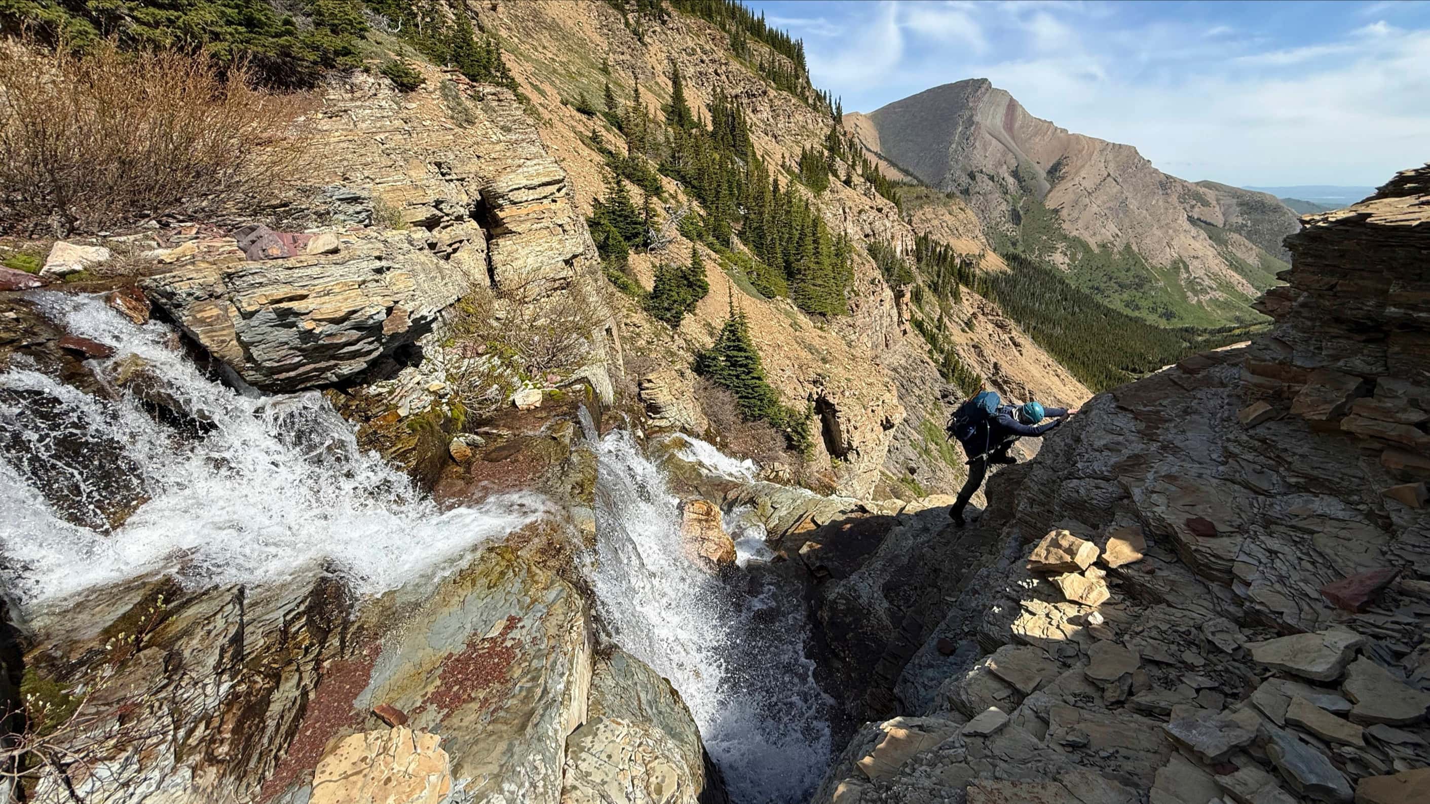
 Just before reaching the first lake we came across this pretty waterfall. It would appear that God liked it too… (Photo by Jeff Lang)

Lakes two and three are situated above a small rock wall at the south end of the first lake.

The lakes are stocked with golden trout and at this point I lamented not bringing my fly rod. I always find that a little bit of chop on these clear mountain lakes makes for good fishing because it provides a measure of security for the fish while also blowing some tasty terrestrials onto the lake. On this day however, the wind was so strong that all three lakes had whitecaps. I will come back another day and bring my trusty, home built 4wt 8’6″ Sage. Of all my rods, this is my favourite. My next favourite is my 4wt 9′ Sage that I use with my tube on alpine lakes. The extra height is helpful when you are casting from close to the water. Anyway I digress…

On the shores of the first lake we came across this abandoned campsite. It was actually quite eerie.

Someone just walked (or ran) away and left their tent behind.

Next to the tent was a lean-to that contained an abandoned sleeping bag and an old sweater. I’m not sure if the occupants intended to leave this stuff behind or not, but it definitely gave off a creepy vibe. We made sure to keep an eye out for any zombies.

We passed by another waterfall on our way to the second lake.

Looking back at the first lake.

As noted by the manifestation of heavenly light, my arrival at the second lake was a blessed event 😉 (Photo by Jeff Lang)

The slope leading to the summit is fairly straightforward.

The third lake can be seen behind Jeff as he begins hiking up the slope to the summit.

Whitecaps bear witness to the strength of the wind. On our way up to the second lake we were being hit by spray coming off of the lake.

Unfortunately, we were a few weeks late to enjoy a scenic hike through the larches.

Just before the summit the terrain turns to rubble.

Jeff captured this cool silhouette as I reached the summit. (Photo by Jeff Lang)

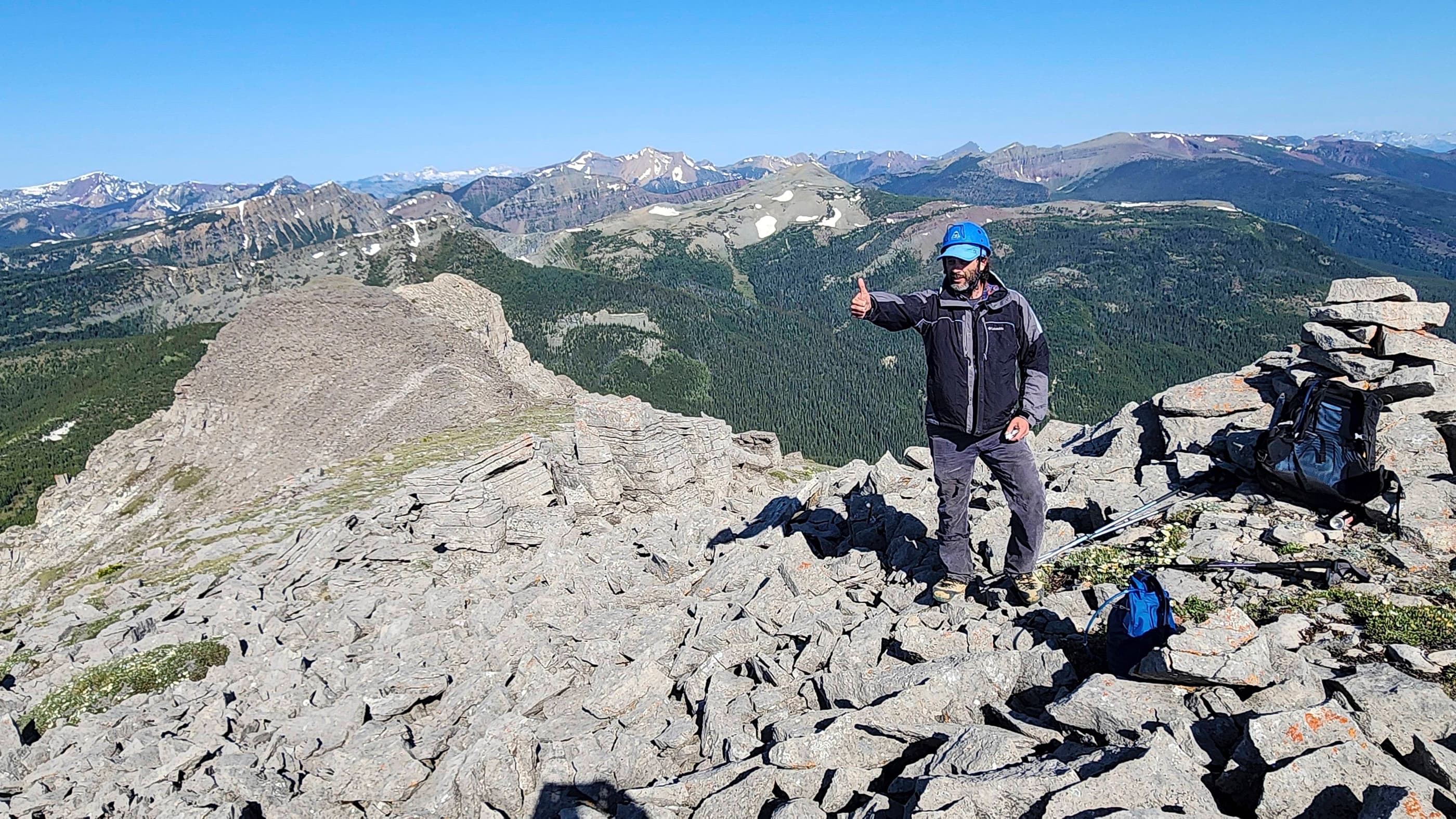
A chinook arch and a large cairn welcomed us to summit of Southfork Mountain (2362m).

Looking west from the summit. From left to right: Mount Haig, Gravenstafel Ridge, St. Eloi, and Syncline Mountain.

The view to the north. Mount Darrah is visible on the distant left as is Mount McGladrey and Mount Couthard. Cherry Hill, Crowsnest Mountain, , Hillcrest Mountain, Turtle Mountain, Byron Hill, and the South Peak of the Livingstone are in the centre. Carbondale Hill, Maverick Hill, and Poker Peak are on the far right.

A telephoto of Mount Haig and Gravenstafel Ridge.

A telephoto of St. Eloi and Syncline Mountain.

Looking east from the summit. From left to right: Table Mountain, ‘Table Top’, Whistler Mountain, ‘Eagle Peak’, Mount Gladstone, Prairie Bluff Mountain, Victoria Peak, Castle Peak, Windsor Mountain, and Loaf Mountain.

The same view as above but with a more southward aspect to include ‘The Amoeba’.

The angle of the sun combined with the chinook arch made for an impressive sky. The sunset later that evening was amazing!

Looking down at the second and third Southfork Lakes from the summit. You can still see the whitecaps.

The registry container was not particularly useful. Curiously though, it did contain some electrical wiring. Obviously this was not a ‘wireless’ registry system 😉

Jeff struggles against the wind as he tries to stand next to the cairn.

It’s not the most flattering of summit pics but the wind’s contortion of my face shows how strong the gusts were. I’m not sure why dogs think it’s so much fun to stick their heads out of the car window when going down the highway, but then again, they also eat their own vomit and feces. Quite frankly, this is how I imagine myself to look when I leave the dentist’s office after a filling.

Looking south from the summit along Barnaby Ridge towards our next destination for the day. ‘The Amoeba” is in the foreground and the summit of Barnaby Ridge is in the distance. Click here to see our Barnaby Ridge report.

Leave a Reply