

 Hiking and scrambling are inherently dangerous activities. Please read my Disclaimer.
Once on the summit of Maverick Hill, it was a no-brainer to continue north along Adanac Ridge to the summit of Poker Peak. Both of us had tagged Poker twice before, but the real draw for a third trip, was the interesting southeast arm of Adanac Ridge. Neither Andy or I had previously visited it and with Ginger Hill sitting as the end point of the arm, it was a win-win proposition. So, as our logic went, by continuing from Maverick to Poker Peak, we could then gain easy access to the start of the southeast arm.
As I’ve written about Poker Peak twice before, I don’t think I need to say much more. However, the neatest thing about Poker is that for my grandson, Oliver, and his mum, Chantelle, it was their first-ever summit. They hiked it with my son, Nathan, on the Labour Day weekend and for that reason alone, Poker Peak will always be a pretty special place. 🙂
Be sure to read Andy’s awesome report!
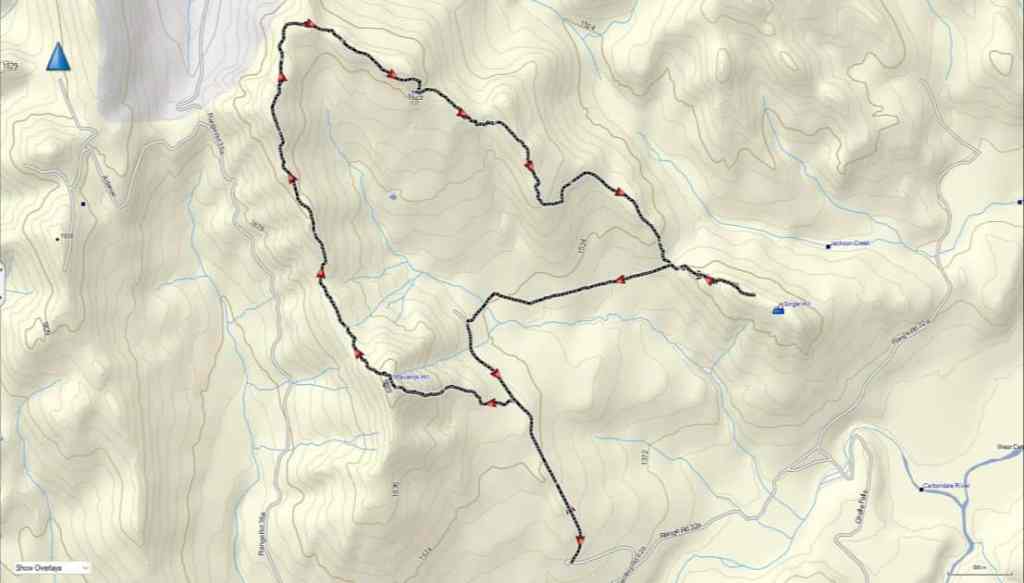
To get to our starting point for Maverick, Poker, and Ginger, we drove west from Pincher Creek along Highway 507 to the hamlet of Beaver Mines. At the T-intersection on the edge of town, we turned right (north) and continued on Highway 507 for ~5.2 km until we came to Township Road 64A. We then turned left (west) and followed the gravel road for ~13.7 km until we came to a side road on the right that led towards a Shell gas well. We turned onto the road and follow it for ~600 m until we came to a locked gate on a hairpin curve. This was our starting point.
From my truck, we hiked along the gas road for ~1.4 km (137 m elevation gain) until we came to a gas well on our left. The well is situated at the base of Maverick and our route started at the north end of the large gravel clearing. An obvious path led onto the slopes of Maverick, but it soon disappeared. However, the route was super straightforward up mostly open slopes. It took us only 45 minutes to reach the summit (1875 m) from the road over ~1.2 km (302 m elevation gain).
From Maverick, we then repeated my April 2016 trip along the ridge to Poker Peak (1935 m). This was an easy ~2.7 km hike that took us almost exactly 1 hour (284 m elevation gain / 206 m elevation loss). The terrain is open and we endured a constant west wind combined with intermittent flurries.
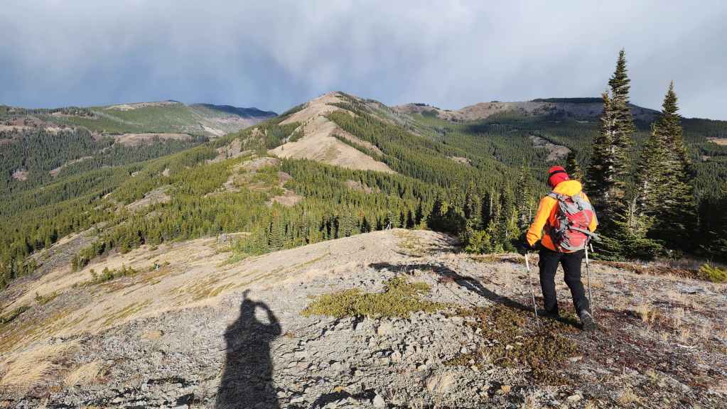
After a very brief stay on the summit of Poker, we set off for Ginger Hill (1611 m). The southeast arm of Adanac Ridge begins just to the north of Poker and connects with the main ridge at a common high point. The hike is interesting, in particular, the rock formation located beneath the highest point of the ridge. The two trickiest parts are: avoiding the deadfall in the small section of new growth just beyond the rock formation and; staying on course towards Ginger once you enter a larger section of forest. To avoid the deadfall, we kept as far to hiker’s right as possible, and to navigate in the trees we relied on our topo map to maintain a constant angle to hiker’s left. Arriving at and then following an old road brought completely back on track.
Once at the col for Ginger, it was a straightforward, 20 minute ascent over ~800 m (147 m) to reach the summit (1611 m). In total from Poker Peak, it was a ~6.3 km hike (310 m elevation gain / 662 m elevation loss) that took us 2 hours and 20 minutes.
Being blasted by wind and snow on the summit shortened our stay and we returned to the col where and the very obvious trail that Sonny and Vern had used. The ~1.8 km (110 m elevation gain) hike back to the road was easy thanks to the great trail and the elevation gain was negligible until the final 100 or so metres before reaching the road, where the trail climbed steeply. In total, it took us only 30 minutes to reach the road from the col.
An easy ~800 m walk along the road brought us back to our starting point for Maverick, and from there, we repeated the ~1.4 km walk back to my truck.
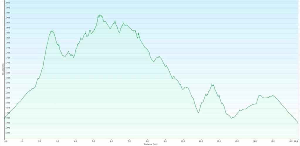
Our total roundtrip distance was 17.2 km with a total elevation gain of 1317 m. Our total roundtrip time was 5 hours and 56 minutes. For reference, the ~2.7 km hike from the summit of Maverick Hill to Poker Peak, took us 1 hour (284 m elevation gain / 206 m elevation loss).
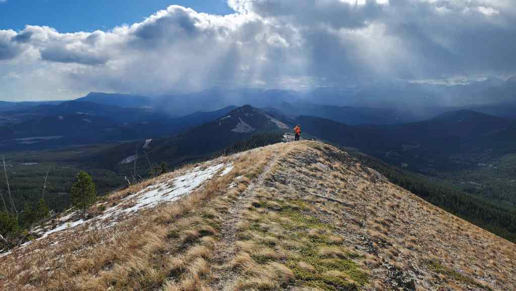
Leaving the summit of Maverick Hill for Poker Peak. The start of the southeast arm of Adanac Ridge can be seen to the right of centre.

Giddy-up! 😂 (Photo by Andrew Nugara)

We were intrigued by the unique-looking terrain on the southeast arm (centre).

We jokingly nicknamed this section of the southeast arm, ‘Flattop’, due to the stand of trees.

Glancing back at the summit. The wind is howling and the snow is coming…

Coming to an interesting, but easily avoidable cliff (centre). (Photo by Andrew Nugara)

A closer look at the cliff.

Here comes the snow… and ice!

Yet another look at the cliff. If the rock isn’t crappy, this might be a neat place to introduce someone to climbing using a top rope – and it’s readily accessible from the Adanac Road… 🤔

More wind and more snow.

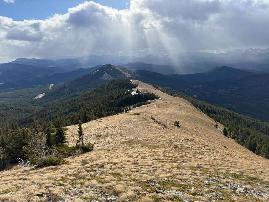
Mighty Ginger Hill (centre) with Blue Mountain (centre) behind it.

The summit of Spades Peak (left) can be seen poking over the crest of Hastings Ridge. (Photo by Andrew Nugara)

The last bit of elevation loss before heading up to the summit (not shown). (Photo by Andrew Nugara)

Almost there.
The view back to Maverick Hill as we near the summit. (Photo by Andrew Nugara)

The summit of Poker Peak (1935 m).
A pano to the south…

And then one to the southwest.

Foreboding skies above Hillcrest Mountain (centre) and Hearts Peak (left).

The view towards Clubs Peak (right).

This was Andy’s third time on the summit of Poker…

And it was my third time on the summit of Poker… (Photo by Andrew Nugara)

But more importantly, Poker was Ollie and Chantelle’s first-ever summit! 🙂 Oh, and this was Nathan’s first time on Poker as well. (Photo by Nathan McMurray)
