

⚠️ Hiking and scrambling are inherently dangerous activities. Please read my Disclaimer. ⚠️
After being taken aback by the abrupt closure of the Victoria Ridge trailhead, and then mucking our way along a bypass route to get to “Prairie Storm”, I was pretty keen on coming back and documenting a better route into the area. If the ‘No Trespassing’ signs are indeed the new normal, then public access to this section of the Castle will have to shift. As I noted in my trip report from November 9th, the quarter section through which the main road runs before entering the park, is privately owned. This means that the trailhead sign that has been there for decades, is now invalid and the first kilometre of the road is off limits to the public.
Initially, I thought the appearance of two, ‘No Trespassing’ signs on the access gate were related to the recent sale of Shell’s Waterton Complex and the surrounding gas wells to Pieridae Energy. However, after our trip on the 9th, I sent an email to Pieridae and they were very quick to check into the matter. Within a couple of days, they informed me that it was the actually the landowner who had initiated this and not them. Fair enough. I’m not sure why the landowner has chosen to do this, but that is his or her prerogative.
When Andrew heard what a cool little winter hike/snowshoe “Prairie Storm” was, he was totally down for joining me on a return trip. He was also good with trying to document a new route into the area as it may mean a new edit for, More Scrambles in the Canadian Rockies – not to mention other guidebooks and online reports.
As I note in my previous trip with Brad, the quarter section of private land is surrounded by the Forest Reserve and Public Grazing Leases. While parking at the gas well located further to south and then accessing the remainder of the road by following the property cutline is doable, it does require crossing Pincher Creek. After our trip on the 9th, I went onto the Recreational Access Internet Mapping Tool and saw that the leaseholder has requested 2 days prior notice before accessing these lands, which is not ideal.
Therefore, I wanted to try a route further to the north, across the Crown Forest Reserve where there are no hiking restrictions. What we found was a fairly straightforward route that required only one very small creek and one somewhat dilapidated fence to cross – though there was a gate as we discovered on the way back. However, it did require gaining ~111m in elevation to reach the upper gas road and then losing ~87m to connect back with the main road. Moreover, without an actual trail, lugging a bike to the upper gas road would not be fun. If indeed, the trailhead remains permanently closed, then it would be good to start to flagging new routes in and this may be one viable option.
Make sure to read Andrew’s awesome trip report!

To get to “Prairie Storm”, drive ~19.5 km south from Pincher Creek on Highway 6 until you reach the Shell Waterton Complex Road (Township Rd. 43A). Turn onto it and drive west for ~9.1 km until you come to a junction with a gravel road near to the entrance of the plant. Turn left and onto the gravel road and continue for ~3.9 km until you reach Butcher Lake. Continue straight for another ~1.5 km, until you come to a Shell pumping house which is the original Windsor Ridge trailhead. Keep following the road as it curves to the right and continue for another .5 km until you arrive at an open meadow on your left where an old set of vehicle tracks lead across. This is the starting point.
We followed the vehicle tracks across the meadow, but as soon as they curved to the right, we continued straight, dropping down a small, aspen-covered slope before then stepping across a very small creek (keep in mind this creek may have more water in it during spring runoff). On the other side, we found ourselves in another meadow where we followed an animal trail to a slope that led up a small ridge. We continued straight and ended up next to another small creek, but in hindsight, we should have curled right and followed the aspen-covered ridge all the way to the gas road. We did this on the way back and I think it worked better.
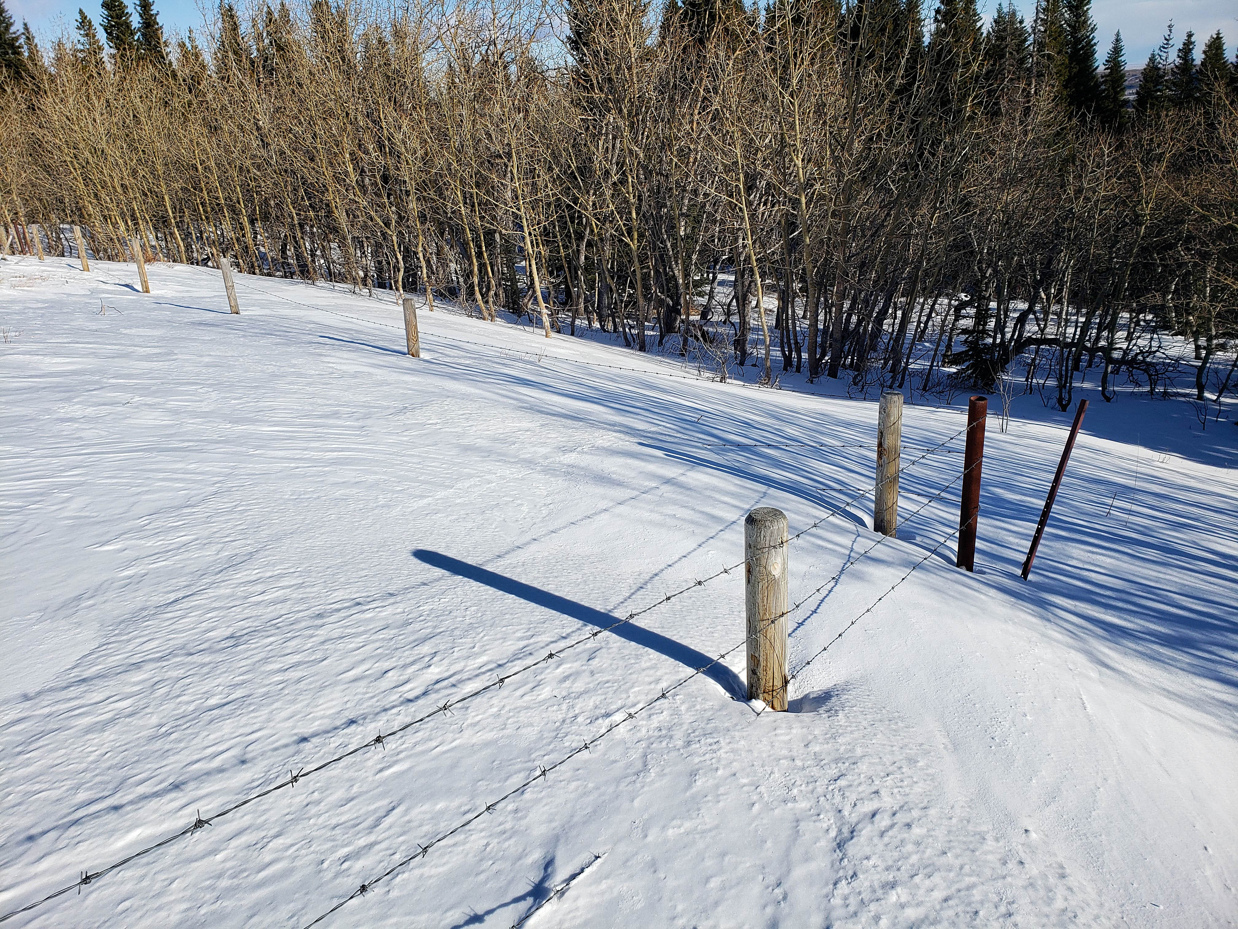
After finding ourselves next to a small creek, we corrected our route and regained the small ridge. We soon found ourselves standing at a junction of fences, with private land on our left and a somewhat dilapidated fence in front of us. The barbed wire fencing that demarcates the private quarter section is in good shape; however, the fence that cuts across public land is not hard to step across, though as we discovered on the way back, there is a gate near the upper road that allows even easier access. From this gate it is a quick, 1.28 km walk down the road to reach the main road. However, know that at this point from the car, it was an ~111m elevation gain and that to reach the main road, it involved an elevation loss of ~87m.
Once back on the main road, we continued walking and in ~300m came to a junction where another gas road winds up the side of “Prairie Sky” and eventually, Prairie Bluff. Instead of taking this road, we continued for another ~700m until we reached a small ridge that connects to the main southeast slope of “Prairie Storm”. From the road, it was a matter of simply following the small ridge and then the main ridge for ~2.2 km (~513m in elevation) to reach the summit. We thought about descending off the summit to the north, but insane wind compression made this impossible, so we returned the way we came. After regaining the ~87m to the upper gas road, we went through the gate and this time, followed the largely open ridge all the way back to the meadow with the creek and then the cars.

Our total roundtrip time was 4 hours and 7 minutes with total elevation gains of ~841m. Our total roundtrip distance was 11.5 km.

The reason for my return trip today. The Windsor Ridge trailhead that has been at this location for decades, now has two, very new, ‘No Trespassing’ signs on the gate. For whatever reason, the owner of this quarter section has decided to stop people from using this route to access the Castle.

The cutlines that demarcate the private quarter section are inside the yellow square. Our route utilized the upper gas road that is next to the lower left corner of the yellow square. Our starting point in the meadow can be seen in the upper left corner.

Our starting point at the entrance to the meadow. In the background on the left is “Prairie Sky”, with “Prairie Fire” in the centre. Part of Prairie Bluff is on the far right.

Walking across the meadow. We would soon leave the vehicle tracks and head into the trees in the centre. The red line in the distance is based on the route we used on the way back, and is what I would recommend following.

Andrew heads towards a small creek.

In the meadow on the other side of the creek. The yellow line represents the route we took on the way in, while the red line represents the start of the small ridge that leads to the upper gas road. We used the red route on the way back and found it to be better.

Following an animal trail across a small meadow.

Andrew arrives at another small creek.

We could have crossed the creek and then followed a cutline on the other side; however, we chose to regain the small ridge that is to climber’s right. (Photo by Andrew Nugara)

Looking back along the small ridge (red) that we should have followed on the way up. Our route (yellow), though a scenic walk in the trees, was not as efficient.

A good look at “Prairie Fire” (centre) from the ridge.

“Bridle Peak” (left) and Pincher Ridge (left of centre) from the small ridge.

Andrew arrives at a junction of fences. The ones on the left mark the boundary of the private quarter section, while the one in front of him separates two sections of public Forest Reserve.

Looking east along the cutline. The private quarter section is on the right.

The view south and down a cutline that leads to the main road. The private quarter section is on the left side of the fence. At this point, I think it is much quicker to continue on to the upper gas road than to try and follow the cutline down to the road.

Andrew prepares to step across a somewhat dilapidated section of fence. On the way back, we discovered a gate that we could use.

On the other side of the fence and heading towards the upper gas road.

The upper gas road.

Looking to the northeast along the road from the point where we joined it. We would keep following this on the way back.

The other possible route that avoids the private quarter section, follows a secondary cutline located south of the large cutline in the centre. This route starts at a gas well that can be reached by turning left and onto a secondary road ~726m from the cattle guard at the west end of Butcher Lake. This route involves wading across Pincher Creek.

Arriving at the main gas road, which is now on public land.

Approximately 300m after joining the main road, we came to the road (right) that leads up and around “Prairie Sky”. However, we would continue straight ahead.

Andrew checks out the southeast ridge of “Prairie Storm” as we walk along the road; however, only the false summit is visible. Brad and I couldn’t see any of this when we were here two weeks ago.

The smaller ridge that we will use to reach the main southeast ridge is directly in front of Andrew.

Starting up from the road.

On the small ridge above the road and looking at the route to reach the main southeast ridge. I’m so glad that Brad and I left all that yellow dye behind to mark the way! 😉

Andrew enters the forest. [Cue dramatic music.]

To snowshoe, or not to snowshoe?

Navigating a steep slope to reach the southeast ridge.

Arriving on the crest. (Photo by Andrew Nugara)

On the ridge and looking across to “Prairie Sky” (left). It may seem tempting to follow the road that winds behind “Prairie Sky” and then cut across to “Prairie Storm”, but there is a significant gorge next to the road that would require a major elevation loss and gain. If following the road is the plan, it is better to keep following it until you reach the the north end of “Prairie Storm”. (Photo by Andrew Nugara)

Two weeks ago we couldn’t see anything at this point because of dense cloud cover. Today, we were treated to this wonderful view.

Andrew leads the way up.

Negotiating a narrow section of the ridge.

The false summit is in the distance. Wait. If you say the false summit is ahead, is that fake news? 😉 (Photo by Andrew Nugara)

Here is where the wind began to get NASTY!

Unfortunately, this section of the ridge is foreshortened.

The view back sees Andrew fighting against the extreme wind gusts. In the distance are: “Cinch Hill” (far left), “Bridle Peak” (left of centre), and Pincher Ridge (right).

Victoria Peak is looking good!

On the false summit and realizing there is more to come. Once you reach the summit ridge, it is another ~275m to reach the summit. (Photo by Andrew Nugara)

A narrow section of the summit ridge.

It should have been an easy walk to the summit, but the wind made us fight for every metre.

Glancing back along the summit ridge.

This was my second visit to the summit (2092m; my GPS) in two weeks.

Gazing west to “Mill Creek Mountain”, “Mill Creek Peak”, North Castle, and Mount Gladstone. On the far right is Table Mountain.

The view to the northeast reveals “Prairie Storm’s” kin with “Prairie Sky” on the right, “Prairie Fire” to the right of centre, and Prairie Bluff on the left.
Just in case you were wondering if it was windy…

Andrew braces himself for a quick picture on the summit. In the background is Victoria Peak.

I look like the Kool-Aid man after he has just busted through a wall. Oh Yeah!

I forgot to build a cairn on my first trip, but this time I remembered. I’m going to call it, ‘Spidey’ after the cool, web-like piece of argillite that I stacked onto it.

We thought we’d drop down the north side of the mountain and connect with the gas road and maybe even follow it to the tops of “Prairie Sky” and “Prairie Fire”… Yeah, no. That was not going to happen as the wind was super compressed going through the col and both of us were knocked to the ground.

Retreating back the way we came.

There is a fun scramble up the gully in the centre of the outlier on the right – hmmm maybe it needs a nickname?

At least the wind was at our backs…

Looking back towards the false summit.

Victoria Ridge sits at the end of the valley. Why I’ve never gotten around to it is a bit of a mystery. Perhaps even Ancient Aliens worthy… 😉

Following our tracks back through the trees…

And onto the road.

It looks a little breezy on the top of Victoria Peak. 😉

After walking for ~1 km we arrived at the turnoff to the upper gas road (left).

It really sucked to have to regain the ~87m in elevation to reach the top.

The road we used is on the right. The upper, upper road is in the centre. 😉

We followed the road until we reached a locked gate.

The locked gate protects a well-site reclamation. Don’t watch the ‘Hills Have Eyes’ before coming here. 😉

Thankfully, just to the right of the locked gate, is a gate that you can use to cross the fence. This is the gate that I was mentioning earlier.

Andrew walks beside the forbidden reclamation site.

Andrew is the all-time Prairie Bluff summit champ!

Looking back as we keep following the fence. The reclamation site is on the right and the mutants themselves, live in the rocks on the side of “Prairie Fire” (right).
Eventually we came to the end of the fence, but we kept going straight.

Entering a short stint in the trees…

Before emerging onto the open ridge that I highlighted earlier.

Looking back along the ridge.

And yet another look back along the ridge. Following this ridge is the best route to the upper road.

Descending through aspens at the end of the ridge.

Arriving back at our tracks from earlier in the day.

The open meadow before reaching the creek.

This beats trying to cross Pincher Creek!

Arriving back at our vehicles. My trusty 4Runner rolled over 400,000 km this month and she’s still going strong.

I stop to ponder life’s great mysteries… 😉 Though this was my second time here in two weeks, it was almost a completely different trip. This was because we used a different way in and we could see where we were going. 😉 Though unlike last time, we did not get the spectacular views that the inversion provided – just a whole bunch of nasty wind. Again, I’m not sure if the landowner will rescind his or her access restriction at the Victoria Ridge trailhead, but the route we used today is one viable option that sticks entirely to Crown land. However, getting a bike in would be difficult. If you find an even better way, let me know!


Leave a Reply