
⚠️ Hiking and scrambling are inherently dangerous activities. Please read my Disclaimer. ⚠️
I’ve waited a long time to complete the famous, Hawkins Horseshoe, as outlined in Alan Kane’s Scrambles in the Canadian Rockies. This premier ridge walk in Paahtómahksikimi (Waterton National Park) incorporates the summits of Piinaquiium / Ahkoinimahstakoo (Mount Blakiston), Mount Hawkins, and Mount Lineham in a stunningly scenic loop. Part of my delay has been my usual distracted nature when it comes to exploring other mountains – squirrel! 😂 – while concurrently, waiting for ideal weather conditions where it wasn’t too hot or in recent years, too smoky. Another significant factor has been a strong desire to avoid the scree in the upper section of Kane’s ascent gully in favour of a better route. This alternative emerged when Andrew and I explored the southeast ridge during our “Igneous Peak” trip last September and ever since then, both of us have been anxious to give it a try. With all these factors in alignment, today was the finally the day – and what a glorious day it was! 😁
However, before I get into the details of the trip, I am going to share why it is important to start using Siksikaitsitapi names for mountains and places. Moreover, as this is the Canada Day weekend, it is fitting to engage with our history and be active participants in decolonization. Rather than being a set of wooden or static facts, history is an evidence-based, methodologically-driven conversation. As new details emerge through research, they are tested and debated before being incorporated into the larger historical narrative. Thus, good history is always seeking to evolve and decolonization is an actionable outcome of this process.
The reality is that most of the early European explorers and settlers, including government agents such as Thomas Blakiston, A.O Wheeler and M.P. Bridgland, saw the Siksikaitsitapi and other Indigenous groups as part of the landscape, and rarely, if ever, engaged in dialogue about traditional names for mountains. Indeed, naming and categorizing geographical features was a common colonial exercise in wresting control and ownership over the land.
The consequences of this on the Siksikaitsitapi is explained by Dr. Ninna Piiksii (Mike Bruised Head / Chief Bird) when he states, “In 1858, Thomas Blakiston claimed the mountain now named after him, and he named the whole area after his friend Sir Charles Waterton – a man who never set foot on that land. That broke wide open the colonial thought of naming mountains after European people. To this day, as Siksikaitsitapi, we don’t know the names of many of the mountains or passes or lakes in Paahtómahksikimi.
The elders tell of stories that each mountain had its own spiritual name and even a spiritual song. The stories and songs have been absent since colonial settlement. It is important for Blackfoot names to make a comeback. The park should be bilingual, and it should include Blackfoot names and signs. The mountains have their own songs.” (source)
In keeping with the PhD research of Dr. Piiksii, I’ve chosen to include Siksikaitsitapi names wherever I can. These names are thousands of years old and by including them, it is one small way that I can participate in decolonization. Though they may be hard for English speakers to pronounce, it is important that they be included as they are integral to our history – for we are all treaty people.
So, what were the original Siksikaitsitapi names for Mount Blakiston? Dr. Piiksii has uncovered that there were two names for this mountain. The first is Piinaquiium or “Seen From Afar Mountain” and the second is, Ahkoinimahstakoo or “Pipestone Mountain”. I’ve chosen to include both when referring to the mountain. I will also note that within the Hawkins Horseshoe, the name of each peak contributes to the historical narrative of the area, and by hiking the loop, you progress through the story.
Now, what about the trip itself? With a clear forecast that devolved overnight into a severe thunderstorm warning for the area, Andrew and I nonetheless set out with a determination to attempt Piinaquiium / Ahkoinimahstakoo (Mount Blakiston) using an alternate scramble route along the southeast ridge. To be clear: I’m sure others have enjoyed this route and we’ve merely stumbled in on the fun. The crux as we had noted from our “Igneous Peak” trip, would be getting past the imposing limestone band without traversing too far from the ridge. To make a long story short, not only did we find a way past the band, but the subsequent trip along the ridge was breathtaking. In fact, the entire route featured fantastic scrambling with minimal loose scree. We eventually joined with Kane’s couloir at the base of the summit block and enjoyed the final ascent to the top.
With the weather holding, we then committed ourselves to the ~4.7 km ridge walk to reach Mount Hawkins, knowing that if the building clouds became threatening, we could eventually follow the trail from Lineham Ridge down to the Rowe Lakes trail. Thankfully, the dark clouds continued to pass by and we enjoyed the ideal mix of sun, clouds, and wind, making for an ideal temperature.
A brief scramble up Mount Hawkins brought us spectacular views of the Lineham Lakes which we then enjoyed for the remainder of our trip along Lineham Ridge. With dark clouds once again overhead combined with physical and mental fatigue, it was tempting to call it a day and descend the trail from the col with Mount Lineham. However, as I’d never visited Mount Lineham, I knew I’d be disappointed if I didn’t suck it up and complete the entire horseshoe. Fortunately, Andrew was graciously game to ascend the peak for a fourth time and so we set off for the summit, thus completing our third and final peak. Unfortunately, the summit of Lineham was largely beclouded, but since we’d enjoyed good views for most of the day, this wasn’t as disappointing as it might be if it had been our only peak for the day.
I have to say that completing the Hawkins Horseshoe feels good – really good. This trip takes in some of the best that Paahtómahksikimi (Waterton National Park) has to offer: great scrambling up the highest peak in the Park; colourful ridge walking; and scenic views of Lineham Falls and Lineham Lakes. Of course, great company makes for a great trip and so a HUGE thank you to Andrew for his willingness to complete the loop for a second time – something I bet not many have done!
Be sure to read Andrew’s excellent trip report! [link coming]

To get to Piinaquiium / Ahkoinimahstakoo (Blakiston) (2910 m) and the start of the Hawkins Horseshoe, we drove from the Waterton townsite along the Akamina Parkway (Cameron Lake Road) for ~9 km until we reached the Lineham Falls trailhead. This was our starting point.
We then hiked down the trail for ~2.9 km until we came to a very obvious drainage. Here is where we left the trail to follow the drainage into the bowl beneath “Igneous Peak” and the southeast ridge of Piinaquiium / Ahkoinimahstakoo (Blakiston). Continuing along the drainage, we came to where it splits into two. Here, we chose the one to climber’s left and enjoyed excellent scrambling all the way up to the limestone band that guards the southeast face. Indeed, though the elevation gain from the trail to the band was ~730 m, it felt easy.
Once at the band, we followed it climber’s left and around a corner where we promptly found a small crack that we could use to scramble above limestone band and onto the crest of the southeast ridge. From here it was a delightful combination of views and scrambling (with minimal loose scree) until we were beneath the summit block. We then followed Kane’s moderate couloir onto the upper slopes of the block and then the summit. For reference, it took us 4 hours and 41 minutes with an elevation gain of 1396 m over 9 km from the trailhead to the summit.
From Piinaquiium / Ahkoinimahstakoo (Blakiston), the remainder of the horseshoe is obvious and we set off for our next objective, Mount Hawkins (2683 m), which sits ~4.7 km away via the ridge. After bypassing a highpoint above the lakes, we arrived at the col with Mount Hawkins. From here it was a easy scramble over ~905 m with a 175 m elevation gain to reach the summit.
After enjoying the views, we continued along the ridge for ~1.6 km to highpoint of Lineham Ridge, where we were treated to more great views of the Lineham Lakes. From here, we followed the Lineham Ridge trail for ~ 3 km to the col with Mount Lineham. The route to the top is not hard, but is foreshortened with a 272 m elevation gain over ~1.6 km.
From the summit of Lineham (2730 m), we descended directly down the open south slope to the Rowe Lakes trail. Once on the trail, it was a ~4 km hike to reach the Rowe Lakes parking lot and then another ~1.3 km walk along the Akamina Parkway to reach my vehicle at the Lineham Falls Trailhead.

Our total roundtrip time was 11.5 hours and our total distance travelled was 28 km. Total elevation gains came in at 2070 m.

Well, it seems we weren’t the only ones off to an early start! 😂 (Photo by Andrew Nugara)

Gearing up at the Lineham Falls trailhead. Though we only used the trail for approach and not for return, our loop would still end here. Ruby Ridge is in the background.

Off to a scenic start.

A sticky purple geranium. The abundance of wildflowers made it hard to not stop for photos every 10 m.

Walking past the east face of Mount Lineham, which is the last peak on the Hawkins Horseshoe and where we will find ourselves a little over 9 hours from now.

Approximately 2.9 km from the trailhead, we came to our ascent drainage. The summit of Piinaquiium / Ahkoinimahstakoo (Blakiston) is hidden by the tree to the right of centre.

Andrew starts up the drainage.

We knew from our “Igneous Peak” trip that this drainage is not only colourful, but is also one of the best ways to gain elevation without feeling like you’re gaining elevation. (Photo by Andrew Nugara)

Red argillite… (Photo by Andrew Nugara)

And more red argillite.

A wicked combo of green mixed in with red.

More of the same.

My view back to Andrew from the previous photo. Mount Lineham is in the background.

Drawing closer to the base of the southeast ridge with “Igneous Peak” on the right. (Photo by Andrew Nugara)

Our route will go straight up the gully in the centre. (Photo by Andrew Nugara)

I carefully avoid a colony of mutant flesh eating clams. 😂 (Photo by Andrew Nugara)

Glancing back to Andrew.

The point where two separate gullies merge into the main drainage. Last September, we used the one on the right to reach “Igneous Peak” and eventually, the southeast ridge; however, today we will use the one on the left just to see what it’s like. (Photo by Andrew Nugara)

Starting up the gully. From this point until we reached the limestone band, it was fantastic non-stop scrambling. 😁 (Photo by Andrew Nugara)

A quick look back at Buchanan Ridge (centre) and Mount Carthew (right of centre).

Up… (Photo by Andrew Nugara)

Up…

And up we go!

Gaining significant elevation with relative ease. I like it! 😁

The great scrambling continues.

A convenient staircase. (Photo by Andrew Nugara)

Yet another look back.

It’s getting steeper but also more colourful. (Photo by Andrew Nugara)

I wonder if a Symbiote would emerge if you cracked this open? 😂

Route finding was never a problem. (Photo by Andrew Nugara)

A quartz sandwich.

Nearing the top of the gully. (Photo by Andrew Nugara)

An interesting layer of hieroglyphic rock.

It’s always weird to look back and not see any of the rock you’ve just climbed – just the illusion of continuous scree.

Approaching the top of the gully and the base of the limestone band. (Photo by Andrew Nugara)

Andrew’s not far behind me.

The limestone band with the southeast ridge on the far right.

Once past the band, our route will continue directly above us. (Photo by Andrew Nugara)

Andrew tackles the final few metres before the base.

Andrew is dwarfed by the limestone band. My theory from our “Igneous Peak” trip, was that the band could be bypassed to climber’s right from the crest of the southeast ridge. My concern was that the shelf above the band would cliff us out once we headed back and across the band. So, while Andrew waited on “Wrong Turn Ridge” (left) – don’t ask me why it’s called that, ‘it just is’ on Google Earth – I continued to our previous trip’s point on the crest.

Andrew’s view over to me. (Photo by Andrew Nugara)

On the crest and looking at the weakness (right) I noted last September.

It was very steep, but definitely doable. My concern was having to backtrack if we were cliffed-out.

A closer look at the ‘nose’ of the band. This is a massive chunk of rock!

The area I was concerned about is on the upper right. It looked like the shelf continued, but I couldn’t tell for sure. To play it safe, I headed over to meet Andrew at “Wrong Turn Ridge” (left) as we knew there were other options just around the corner.

Enjoying a quick break on “Wrong Turn Ridge”. A beclouded Mount Lineham is in the background.

A pano showing the view around the corner. Kane’s route is the long snow gully on the right.

Our first look at the Lineham Lakes and Lineham Falls. Later in the day, we will be treated to some awesome views of the lakes.

A closer look at the lowest Lineham Lake.

Zeroing in on Lineham Falls.

We knew from before that there were other options to get past the band – we just had to find the right one. The crag on the right was possible, but definitely wasn’t our first choice… (Photo by Andrew Nugara)

However, the backside of the crag was ideal! 😁 (Photo by Andrew Nugara)

We just had to overcome one tricky step and then we were good to go. (Photo by Andrew Nugara)

Andrew follows me up. The location was ideal as it was super close to “Wrong Turn Ridge”.

Loose scree covers the area immediately above the weakness.

The remainder of the limestone band was easy from here.

On top of the band and looking at the shelf where I was concerned we would be cliffed-out. From here, it looks like going climber’s right from the crest of the southeast ridge (far right) and then following the next set of cliffs over to my current vantage will work. 😁

On the crest and looking towards the summit block (left).

Andrew climbs up to join me,

Looking down directly onto our ascent gully with a partially beclouded “Igneous Peak” on the far left.

While I continued along the crest, Andrew briefly opted for scree. Kane’s route is the snow gully just above Andrew.

This part of the ridge was wicked awesome! 😁

Looking back after climbing a large step. (Photo by Andrew Nugara)

The clouds contributed to the dramatic scenery.

I continue to lead the way. (Photo by Andrew Nugara)

The view east.

Getting closer to the summit block. (Photo by Andrew Nugara)

I must’ve snapped a hundred photos as we made our way along the ridge. 😳

A pano from the vantage in the previous photo.

Andrew was also taking a ton of photos! (Photo by Andrew Nugara)

This route was definitely coming up Millhouse! 😂

I can’t…

Stop…

Taking photos.

Gazing down the east face.

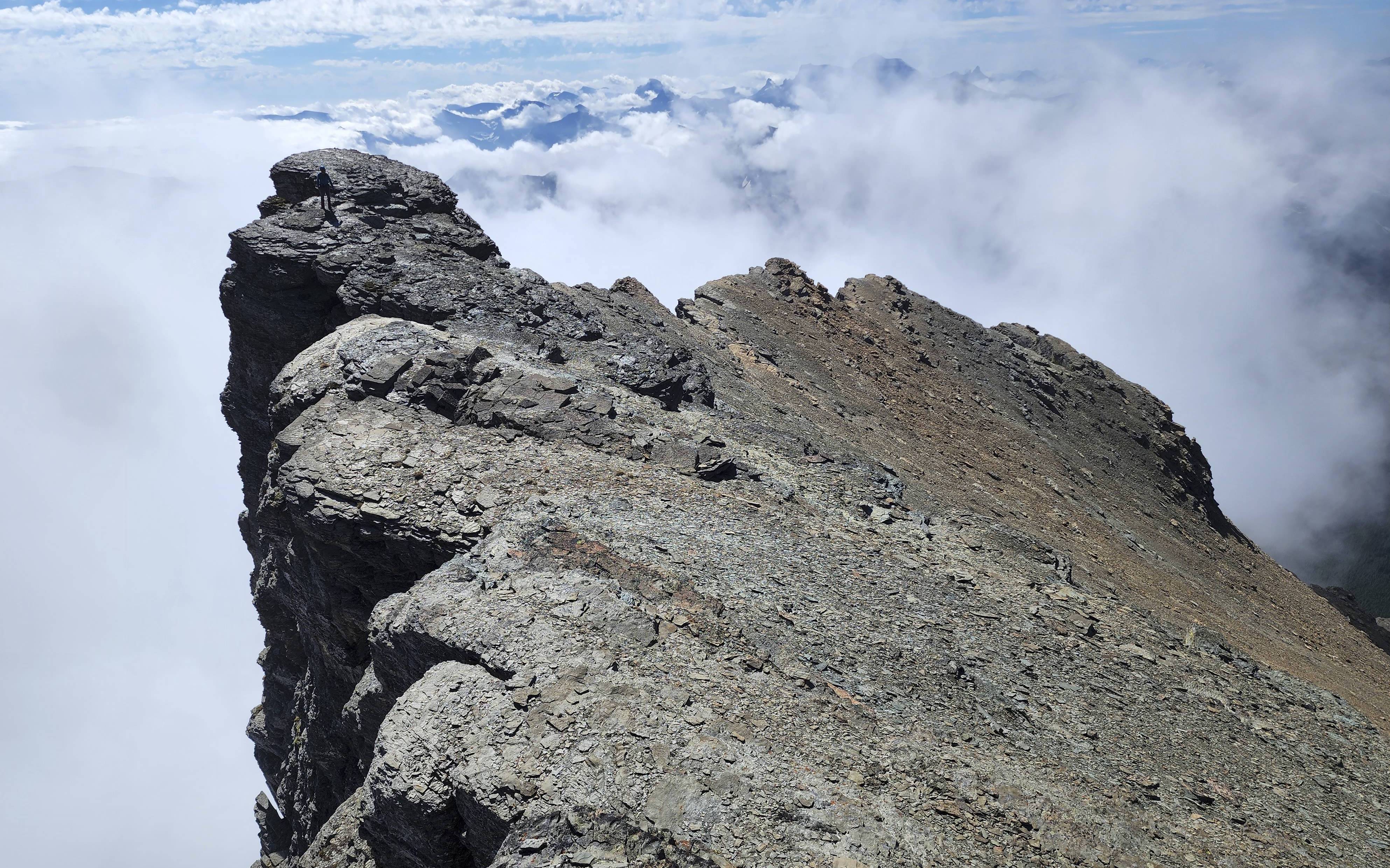
My favourite photo from the ridge – note Andrew on the upper left.

Gazing along the ridge to the southeast.

Andrew peers into an insanely deep gap.

Yet another view back and along the ridge.

Arriving onto Kane’s route and heading up to the base of the couloir. (Photo by Andrew Nugara)

Kane’s couloir is on the right.

Gazing up from the base.

I’m about halfway up the couloir. (Photo by Andrew Nugara)

Almost there! (Photo by Andrew Nugara)

Looking down from the top.

Andrew’s turn!

The terrain above the couloir was more inviting.

We each chose a different route onto the ridge. By trending climber’s right, I emerged closer to the summit.

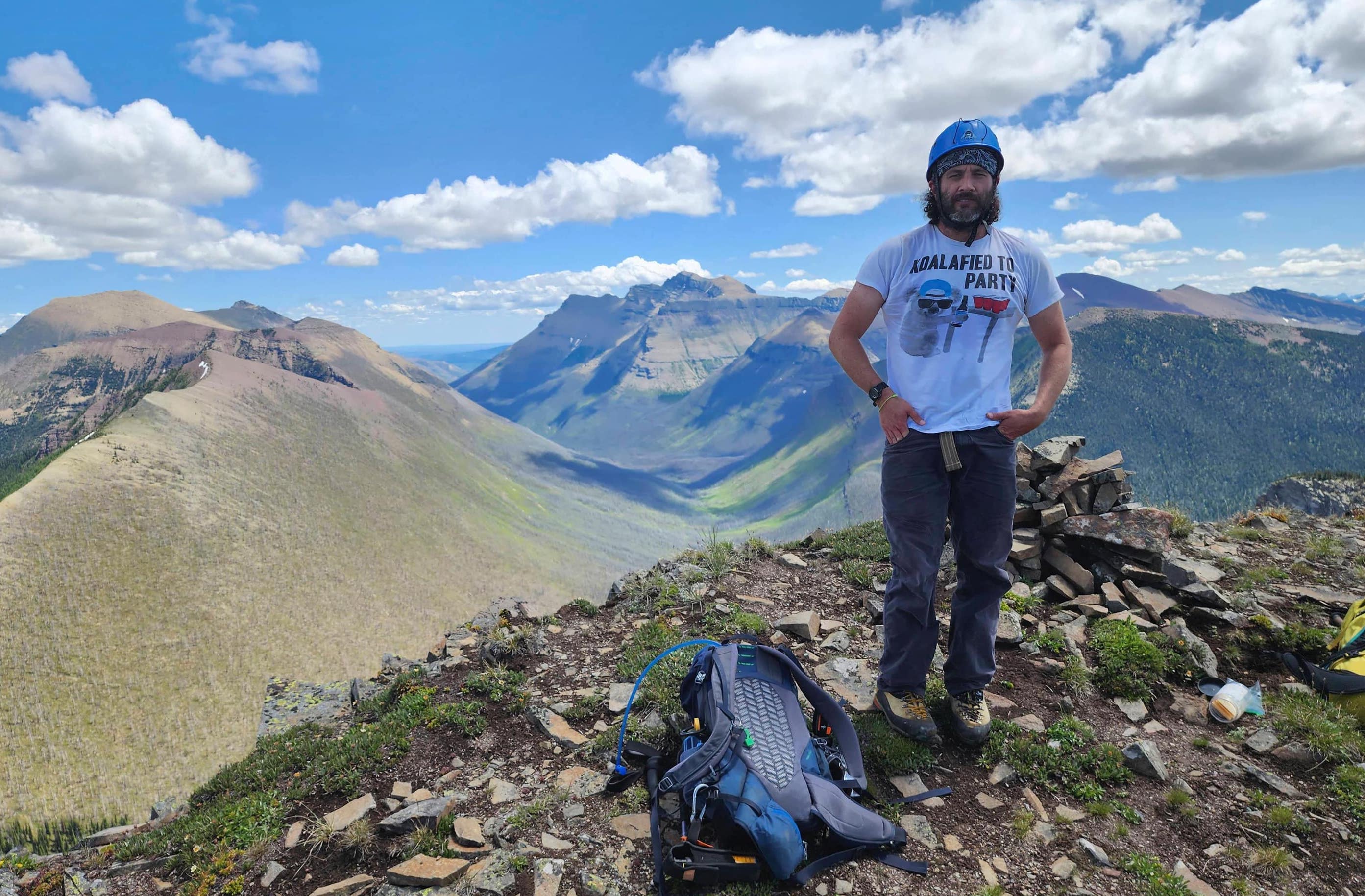
The summit of Piinaquiium / Ahkoinimahstakoo (Mount Blakiston) (2910 m). Long before Thomas Blakiston explored the area, the Siksikaitsitapi had two names for this mountain. The first is Piinaquiium or “Seen From Afar Mountain” and the second is, Ahkoinimahstakoo or “Pipestone Mountain”.

A pano to the north…

And then one to the east.

Looking southeast…

And now to the west.

Finally, a pano to the northwest.

Andrew joins me on the summit after emerging further down the ridge.

Gazing down at our route along the southeast ridge.

“Newman Senior” (centre) is still on my ‘To Do’ list. EDIT: Done!

Clouds accentuate the summits of Mount Glendowan (left) and “Cloudowan Peak” (right). Unfortunately, Cloudy Ridge (far right) is living up to its namesake.

A closer look at the summit of Mount Glendowan.

The super cool summit of “Cloudowan Peak”.

In the distance is Niitaaspiitaa (Mount Cleveland) which means “Only Tall Mountain” in Blackfoot.

Mount Alderson (left of centre) with Buchanan Ridge (centre) in front of it. On the far right is Mount Carthew with “The Senator” foreground left.

Anderson Peak sits to the northwest.

Sharing the ridge with Anderson are Lost Mountain (foreground centre) with “Kootenai Brown Peak” immediately behind it.

Mount Bauerman (centre) is the last peak on the Anderson ridge.

Kishinena Peak (centre) is another mountain I still have to visit… EDIT: Done! 😀

As is Lone Mountain (centre) EDIT: Done! 😀.

A telephoto of Kinnerly Peak (centre).

Mount Carter and Rainbow Peak are to the right of centre.

A telephoto of Long Knife Peak (centre).

Glancing across the valley to Mount Lineham – the final peak in the Hawkins Horseshoe.

And now looking towards our next destination: Mount Hawkins (centre).

Andrew’s second time on Piinaquiium / Ahkoinimahstakoo (Mount Blakiston).

A cool pano by Andrew.

I feel very privileged to stand on the highest point in the Park.

Andrew leads us towards Mount Hawkins. Click to continue our journey along the Hawkins Horseshoe. 😊


Leave a Reply