
⚠️ Hiking and scrambling are inherently dangerous activities. Please read my Disclaimer. ⚠️
When I first ascended “Blue Mountain” in January 2017, I was amazed at how fun this little foothill turned out to be. Subsequent trips in 2018 and 2020 further solidified this as my favourite foothill in the Tatsiki-Miistáki area. Adding nearby, “Screwdriver Ridge” in May 2020 as a loop and then in combination with Mount Backus in December 2020, convinced me that the entire area around “Blue Mountain” is a hidden gem for hiking and snowshoeing.
So, when Raff mentioned that he was going to make his first trip up “Blue Mountain”, I selfishly invited myself along as ‘tour guide’. 😂 Not being able to make it out to the mountains in 2.5 months due to either weather, family activities, or a lingering cold meant a fourth trip up “Blue” and a third trip up “Screwdriver” was just what the doctor ordered.
Now I will say that my prolonged absence away from the mountains, was filled by my other hobby which is fixing and restoring old video game consoles. On those crappy weekends when the snow was flying, I was able to bring back to life, several cool vintage systems including a rare, Bally Astrocade that I purchased off Ebay as a non-working unit. After replacing the electrolytic capacitors along with a few other parts, it was awesome to see this unique piece of history spring back to life. It now joins the rest of my collection which includes over 25 restored game systems from the 1970s through to the early 2000s. My current project involves restoring a non-working Turbo Grafx 16, so who knows, maybe one day I will add a dedicated ‘trip report’ page about these systems. 🤔 Yup, I’m definitely a huge geek. 😂
Anyway, back to today’s trip. As always, it was awesome to get out with Raff, especially on a day with such amazing weather! With temperatures in the mid-twenties and little to no wind, it felt like early summer – and I have the sunburn on my forearms to prove it.
Once on the top of “Blue”, we headed over to “Screwdriver Ridge” a little unsure as to whether we would encounter lingering deep snow in the trees. Though we had originally planned to follow a ridge above the drainage where Brad and I descended off “Screwdriver” in May 2020 because it looked relatively snow-free, we ended up following almost the exact same ascent route from that trip. I’m going to say, once you are in the trees beneath “Screwdriver” it becomes a bit of a Bermuda Triangle where it’s easy to lose your bearings and think you are further to the north or to the south than you actually are. Of course, you could cheat and use a GPS, but that wouldn’t be fun would it? 😂
After enjoying the great views from the top of “Screwdriver”, Raff and I descended to the road using the ascent route that Andrew and I used in December 2020. This made for a nice loop with a leisurely walk back to our vehicles. Had we’d been thinking, we would’ve parked a vehicle at the gate (or after May 1st, further down the road) but no matter, the walk was a great way to end the day. A huge thanks to Raff for allowing me to tag along! 😁

To get to Blue Mountain, we drove west from Pincher Creek on Highway 507 to the hamlet of Beaver Mines. At the T-intersection on the edge of town, we turned right (north) and continued on Highway 507 for ~1.1 km until we came to Township Road 6-2A. We then turned left (west) and followed the gravel road for ~2.8km until we came to a side road on the right that led to a Shell gas well. Here we parked on the side of the road just beyond an obvious cutline. This was our starting point.
The cutline demarcates private land and leased public land. All the land to the north of the cutline is leased public land and the leaseholder does not require contact prior to access if you are on foot. Nevertheless, this land is the livelihood of the leaseholder and so a high level of respect is required. A barbed wire fence runs up the middle of the cutline and I stayed on the north side of it until I reached the SE ridge. From here, we enjoyed the fun walk along the ridge until we came to where it intersects with the south ridge. The summit lies ~400 m to the north.
After spending a relaxing time on the summit, we decided to venture over to “Screwdriver Ridge” (1691 m), a slightly lower foothill located ~2.1 km as the crow flies to the west of “Blue Mountain”. Back in 2017, I had thought about making the two destinations into a loop, and back in May 2020 Brad and I proved it is a good loop. Be warned though, “Screwdriver Ridge” appears much closer to Blue Mountain than it is. It took us ~3.5 km of hiking to reach its summit.
From the summit of “Blue Mountain” we made the ~783 m trip to the top of an intervening ridge that Brad dubbed, “Meadow Mountain” because of the immense meadow on its west slope. We then descended another ~934 m to the valley floor, before beginning a relatively easy combination of bushwhacking and intermittent trail following for ~1.8 km towards the summit of ‘Screwdriver Ridge”. The final ~100 m or so up the south side to the summit was quite steep but otherwise, was not difficult terrain.
To descend, we used Andrew and my December 2020 ascent route which is a straightforward ~2 km trip (270 m elevation loss) down open grass slopes to the road. We had to cross a fence which we did by easily belly-crawling under it. Fences are important and so I always try to find a spot to cross where I don’t have to touch it so as to prevent damaging it – or me. We then followed the road for ~1.3 km until we came to a locked seasonal gate. After crossing the gate it was a short ~1 km walk back to our vehicles.
Please note: that the first ~900 m west of the gate, there is private land on either side of the road. The accessible public grazing lease does not start until you cross over the cattle guard ~900 m from the gate. While “Blue Mountain” is especially tempting to try from this section, don’t do it. An alternate access for “Screwdriver” and “Blue” begins through the gate at the cattle guard on the road, this way the fence doesn’t have to be crossed.

Our total roundtrip distance was 11 km with a total elevation gain of 657 m. Our total roundtrip time was 4 hours and 45 minutes.

It’s a Toyota-fest! 😀 Gearing up near the start of the cutline.

Raff starts along the cutline. Note that the land on the other side of the fence is private. There is also a trail that can found further up the road, but I always find this to be a direct and easy way to gain the ridge.

An emerging pasqueflower signals that spring is here – or in today’s case, summer as the temperature was in the high 20’s.

Gazing back from the upper section of the cutline.

More pasqueflowers.

On the ridge and looking at the south (left) and southeast ridges of “Blue”. We would ascend the southeast ridge, but you could also head over and ascend – or descend – the south ridge. If you do chose the south ridge, be sure to check out ‘baboon rock’ while you’re at it!

Starting up the interesting southeast ridge.

Raff navigates the narrow ridge.

The whole southeast ridge is about 1 km in length.

I’ve long thought that these slabs would be a good place to teach kids some climbing skills. 🤔

Nearing the top of the ridge, though the summit is still not visible.

Raff arrives at the top of the ridge.

From the top we can finally see the summit (left).

Raff was pleasantly surprised by the views. Wait until he gets to the summit… 😀

Looking back and along the southeast ridge.

Heading towards the summit.

Gazing towards “Screwdriver Ridge”.

On my first trip up “Blue” in 2017, I made the comment that the summit was ‘perky’. I still think that is an accurate descriptor.

The summit of “Blue Mountain” (1715 m).

‘Steve’, the cairn that I built in 2017 is still here.

But wait. What’s this? ‘Steve’ seems different…

Someone has placed an ammo box inside of him…

Along with a register! “Blue Mountain” has made it to the big leagues! 😂😂 Not even Mount Ptolemy has a register. Well done “Blue”, well done! 😂😂

Raff signs the new register.

Looking south at Prairie Bluff (far left), Drywood Mountain, Pincher Ridge, Victoria Peak, and Victoria Ridge. In front of Victoria Peak are “Whitney Creek Mountain” and “Whitney Ridge”.

A telephoto of “Gladstone’s Toe” (far left), Mount Gladstone, and Table Mountain.

Table Mountain (centre) and in the foreground on the right, Mount Backus.

A closer look at Mount Backus. You could loop “Blue”, “Screwdriver Ridge”, and Backus together as a trip. It would be long, but not too bad. Andrew and I made a loop out of “Screwdriver” and Backus in December 2020, and I know that “Blue” loops nicely with “Screwdriver”, so connecting all three in one trip is very doable.

“Screwdriver Ridge” (foreground) will be the day’s next destination. Behind it are the three peaks of Mount Syncline.

In the foreground on the left is Carbondale Hill with Carbondale Ridge extending across the centre. Behind it are Mount McCarty (centre) and Hollebeke Mountain (far right).

Another look at Mount McCarty (left), Hollebeke Mountain (centre), and “South Flathead Peak” (far right).

A good look at “South Flathead Peak” (left), Centre SE1 (centre), and Centre Mountain (right). In the foreground centre is Centre E3 (“North Kootenay Mountain”).

Darrah S2 (centre) is one of the higher, unnamed peaks on the Flathead Range. A much smaller, Darrah S3 sits immediately to its left.

If possible, I would love to make it up Mount Darrah this year…

Gazing over to the north end of the Flatheads and in particular, Ptolemy SE5 (another one high on my list) and Mount Coulthard (right). Andy Good Peak can be spotted immediately behind Ptolemy SE5.

Today (April 29th) marks the 120th anniversary of the Frank Slide on Turtle Mountain.

Zooming in on Omahkai’stoo and the Seven Sisters. Byron Hill is in the foreground.

Looking onto the prairies.

Raff follows as we continue along the summit ridge.

Looking across to Burmis Mountain.

A wider angle of the previous photo.

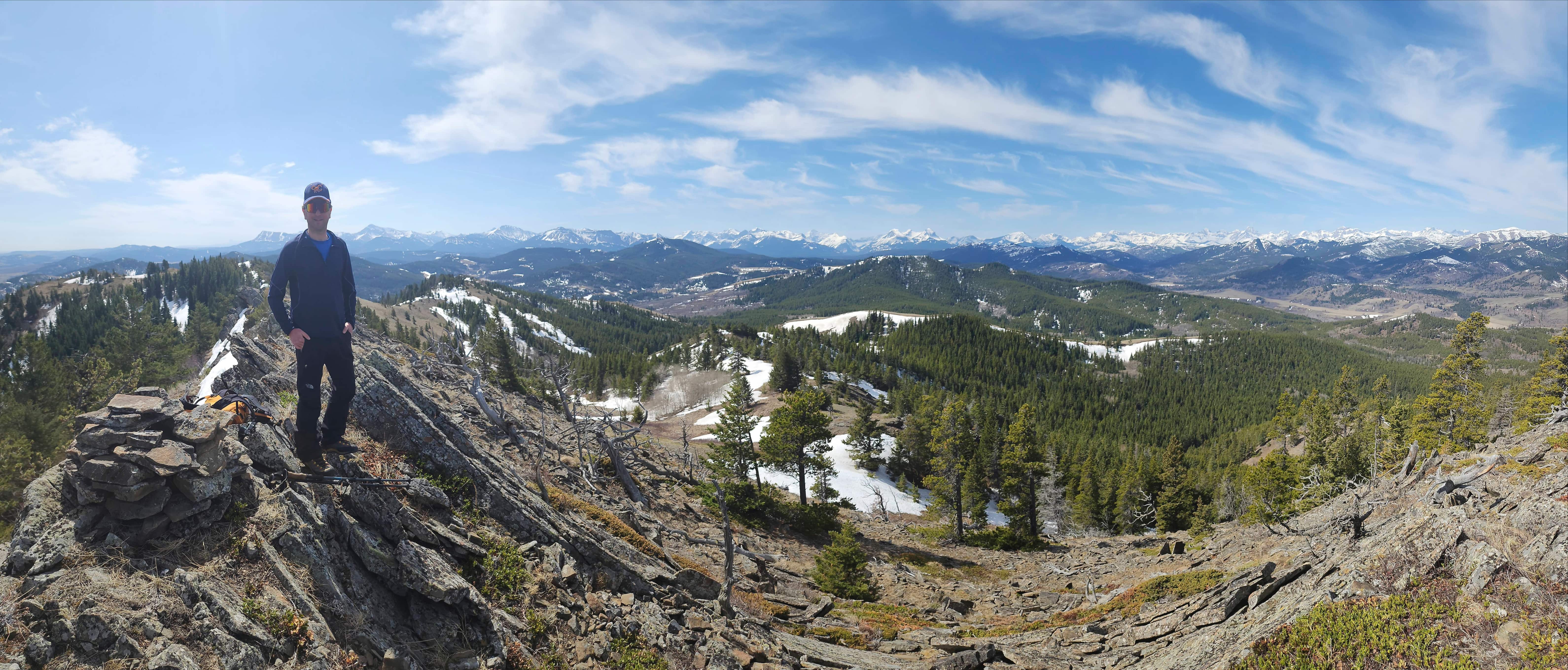
A pano to the northwest…

And finally to the west.


Leave a Reply