
⚠️ Hiking and scrambling are inherently dangerous activities. Please read my Disclaimer. ⚠️
Though not my first choice of destinations for the day, McGillivray Ridge and nearby, Ma Butte, ended up being the right choices to make given the circumstances. Originally, I had planned to head up Centre Mountain in the Flathead Range, but when I woke up with a sore throat and then heard the windows on my house rattling from the intensity of the wind, I knew this wasn’t going to happen. After bouncing around some alternate and more modest destinations, I suggested to Jeff that we try McGillivray Ridge and Ma Butte, as the effort to reach these two smaller summits would fit with how lousy I was feeling. Besides, they both appear in many of the pictures that I’ve taken of the Crowsnest Pass and it would be nice to finally see what they had to offer.
Since the wind was howling – again – I knew that we didn’t want to take the traditional route up McGillivray Ridge which would mean a long, south to north ridge walk to the summit. Instead, we chose to take a more direct route by crossing an old forestry clearing and then ascending up a drainage located just south of the summit. This way we would be sheltered from the wind and would only have to face it during our jaunt to Ma Butte. It would also cut several kilometres off of our trip which turned out to be a great thing because the weather was quite unstable despite the forecast calling for clear skies, and just as we reached our vehicle at the end of our hike, an ominous looking cloud opened up with rain and sleet. We had timed things perfectly and after looking at similar darkened skies to the south near to our original destination of Centre Mountain, we were pretty sure we’d be getting blasted by wind and rain.
In all, McGillivray Ridge and Ma Butte ended up being the right choices to make on this day. They also offered up some spectacular views of not only Crowsnest Mountain and the Seven Sisters, but the surrounding region. The hike is not difficult for someone who is fit and is definitely something that I would use to introduce off-trail hiking, as any of the scrambling we did could be avoided. The only thing I would change if we did our route again would be to ascend and descend on the north side of the drainage. We ascended on the south side through the trees and descended on the north side, where it is mostly clear. Definitely use the north side…

The usual way up McGillivray Ridge involves parking near the south end of the mountain just off one of the ‘S’ curves (pictured on the far left) and then following a trail to a cutline which is then used to gain the ridge. Since we wanted to avoid the long ridge walk because of the wind, we chose to go through an old forestry clearing and then up a drainage that is located almost directly beneath the summit.
Access to the clearing can be hard to see from the road, but the odometer on my 4Runner said it was 11.1km from where the pavement turns to gravel just after leaving Coleman and 8.8km from the first cattle guard you cross on Hwy 40. As I mentioned before, I would suggest using the north side of the drainage to both ascend and descend unless you like game trails and bushwhacking. Once near the top of the ridge, the cliff bands provide a short but fun section of scrambling (watch for some loose rock), but these can be avoided altogether by walking along their base northwards toward the summit. We scrambled up the cliff bands but avoided trying to down climb them using this route. It ended up being 2.83km from our vehicle to the summit of McGillivray Ridge which I’m guessing is quite a bit shorter than the usual route that comes from the south.

Our total hiking distance for achieving both summits was 9.3km. For McGillivray Ridge, it was 2.83km from our vehicle to the summit. From the summit of McGillivray it was 1.88km to the summit of Ma Butte which included an elevation loss of 166m and then an elevation gain of 177m. Total elevation gains for the day were 1001m and the total time was 5 hours and 11 minutes, which includes the ~40 minutes we spent eating lunch on the summit of Ma Butte.

If you blink, you will miss the entrance to the clearing which is 8.8km from the first cattle guard crossing on Hwy 40 after leaving Coleman. Since it is the fall, the area was full of hunters trying to spot game. As we were gearing up, some friendly hunters from the Pass pulled up next to us and asked where we were going. When I told them, they said to keep an eye out for the grizzly that is frequently seen on the slopes of McGillivray Ridge. He then added that the old boar didn’t usually cause people trouble. I noted that bears usually ignore hikers IF they know we are coming and that most of my bear encounters have been while I’ve been in stealth mode while fishing and he agreed, saying that hunters are in the same boat as fisherman. He also mentioned that there were at least 9 grizzlies currently living in the valley. He then told us that they had just seen a bull moose and cow 75 yards down the road from our current location which somewhat concerned me because I’m quite wary of bull moose (remind me sometime to tell the story of being followed by a swimming bull moose while crossing Hector Lake in my float tube in Banff National Park…).

A good view of McGillivray Ridge appears once you enter the clearing. The summit is on the right and our route went up the bare slopes in the centre of the picture.

Looking back across the clearing before ascending the drainage.

Even though we could see that the north side of the drainage was relatively clear, we thought we’d try ascending up the south side by following the multitude of game trails. Though the bushwhacking wasn’t that bad, we should have stuck to the north side of the drainage. Knowing that a grizzly frequented this area, we made sure we were as loud as possible. (Photo by Jeff Lang)

Looking up at the top of McGillivray from inside the drainage. We should have stayed to the right (north side).

The section of the Livingstone Range between Thunder Mountain and Centre Peak as viewed from the south side of the drainage.

The cliff bands at the top of McGillivray Ridge can be avoided by following them northwards (right) to just below the summit. We chose to go straight up and over them, but avoided them on the way down.

The view to the northeast from the base of the cliff bands. Thrift Peak and the Livingstone Fire Lookout are on the left and Thunder Mountain is in the centre.

Looking east at “Lightning Peak” (right of centre) and Centre Peak on the Livingstone Range (right of centre).

Be careful of loose rock when scrambling up the cliff bands. There are several route options to choose from but make sure no one is directly below you while ascending.

Jeff prepares to scale a small cliff band located beneath the main cliffs.

Looking back at our ascent route from the base of the main cliff band. Centre Peak is fittingly in the centre of the picture.

Jeff enjoys the view from the base of the main cliff band.

Due to loose rock, we stuck close together while scrambling up the short cliff band.

Jeff makes his way up the last few meters before the top of the Ridge.

A spectacular view of Crowsnest Mountain and the Seven Sisters greeted our arrival onto the top of McGillivray Ridge. Mount Tecumseh can also be seen on the far left.
 Our second destination for the day, Ma Butte, appears in the foreground. Mount Ward, Window Mountain, and Allison Peak are in the distance.

Looking north along McGillivray Ridge from the top of the cliff bands.

Jeff admires the stunning view.

Looking south along the Ridge as Jeff makes his way toward the summit. Wedge Mountain (centre) and “Pa Butte” (right of centre) are in the background.

This view is one of the reasons why we hiked to the top of McGillivray Ridge.

The summit of McGillivray is somewhat uninspiring.

The summit marker is located within the ruins of a scattered cairn.

My GPS readings on the summit.

The view south from the summit of McGillivray Ridge. This is why both McGillivray and Ma Butte are in so many of my pictures. Willoughby Ridge, Wedge Mountain, “Pa Butte”, Mount Coulthard, Mount McLaren, Andy Good Peak, Mount Parrish, Chinook Peak, and Sentry Mountain are all visible.

The view to the west includes Crowsnest Mountain, the Seven Sisters, Ma Butte, Allison Peak, Window Mountain, and Mount Ward.

The view to the northwest. Racehorse Mountain is on the left and Gould Dome is on the right. Tornado Mountain, located behind Gould, is obscured by cloud cover.

Looking north at “Vicary Creek Ridge”.
The view to the northeast. In the far distance on the left is Mount Livingstone and Coffin Mountain. Thrift Peak is in the centre and Thunder Mountain is on the right.

Jeff admires the view of Centre Peak (right) from the summit. Thunder Mountain and “Lightning Peak” are on the left.

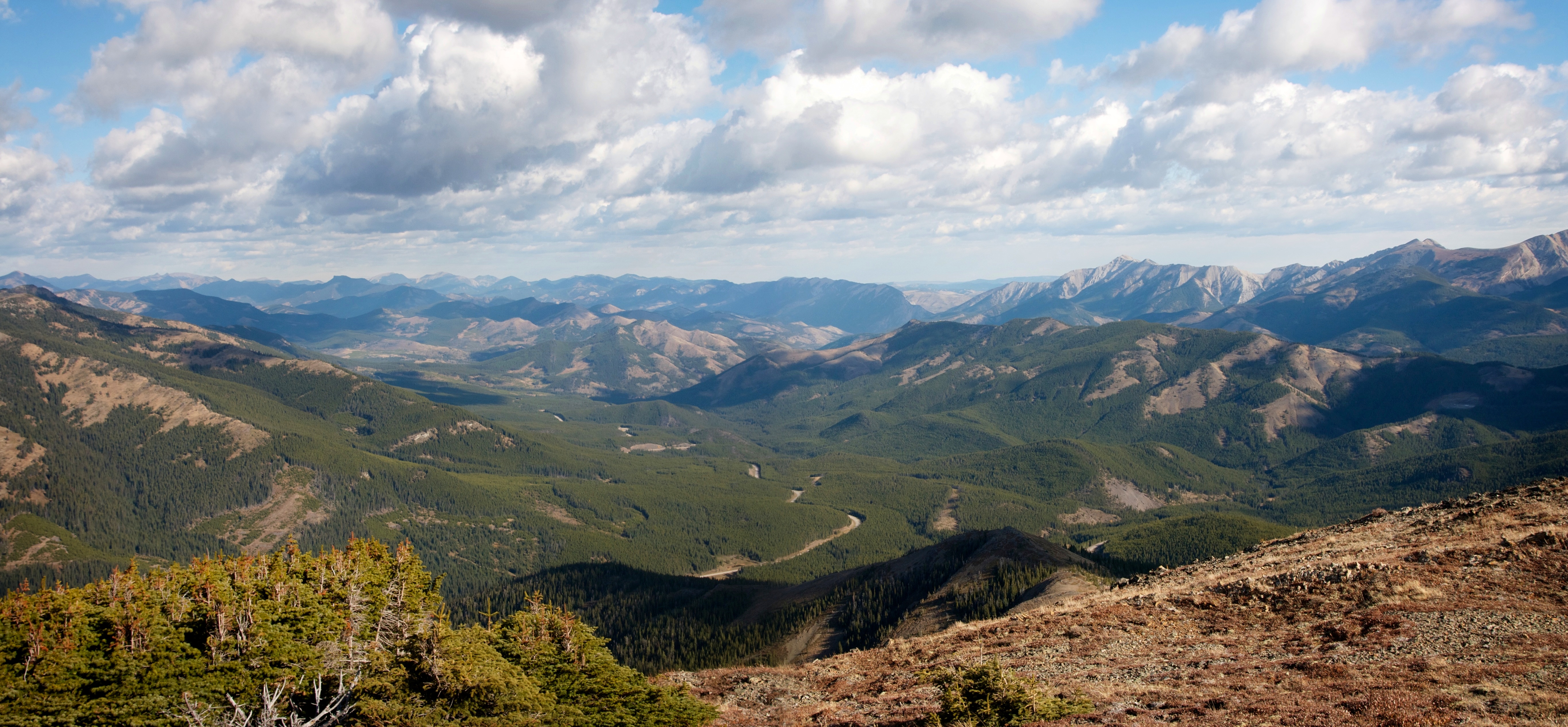
The view to the southeast includes Grassy Mountain, the South Peak of the Livingstone Range, Morin Peak, “The Dog”, the Piitaistakis Eagle Watch Site, Robertson Peak, Tallon Peak, Bluff Mountain, Turtle Mountain, and Hillcrest Mountain.

The view back along the Ridge to the south. Barely visible on the far distant left is Prairie Bluff Mountain. Also barely visible in the far distance is Southfork Mountain, Syncline Mountain, and Mount McCarty. On a clear day, many more mountains in the Castle Crown Region would be visible. McGillivray Ridge offers some great views!

And one last look to the southwest.

Jeff stands next to what is left of the summit cairn.

Oh, I should mention that the wind was ripping at this point and we had to brace ourselves on several occasions.

I know I’ve shown it several times before, but this view is one of the reasons why McGillivray is a good destination choice if you’re looking for one that doesn’t require too much work.

After bundling up to face the wind, we then set off for the summit of Ma Butte – a distance of only 1.88km over easy terrain.


Leave a Reply