
⚠️ Hiking and scrambling are inherently dangerous activities. Please read my Disclaimer. ⚠️
Today was all about finishing what I had started last week, when I aborted my planned solo trip to Allison Peak in favour of “Mount Racehorse”. Feeling back to normal and eager to get to a summit that I’ve had on my list for years, I looked forward to exploring an alternate ascent route that utilized the long, curved ridge leading up from Racehorse Pass. I was also thrilled to be joined by my friend, Mark Kadijk, who I hadn’t hiked with in more than a year. Mark is an excellent mountaineer and an overall awesome human being. Time spent with Mark always seems to generate great conversation.
A prominent landmark in the Crowsnest Pass, Allison Peak was officially named on July 22, 1915 by Dominion Land Surveyor, Morrison Parsons Bridgland. Bridgland chose the name to honour, Douglas Allison, an early settler in the Crowsnest Pass who died on August 4th, 1912. Allison, who was born in 1854 in the Compton Estrie Region of Quebec, had served in the North West Mounted Police in the Macleod area from May 25th 1875 to May 25th 1878 (Honoured in Places: Remembered Mounties Across Canada by William Joseph Hulgaard, John Wesley White, p. 14). According to Hulgaard and Wesley, Allison had been disciplined by his superiors in November 1876 for being “improperly dressed out of barracks,” which the authors suspect was merely a failure to have his coat buttoned correctly. (p.14.) Nevertheless, this admonishment did not hinder his advancement, as Allison would go on to reach the rank of sergeant. (“Came to Alberta In The Very Early Days”, Lethbridge Daily Herald, August 6, 1912, p. 1)
After owning a successful ranch located three miles west of Macleod, Allison moved to the Crowsnest Pass in 1891, eventually settling on a quarter section of land “a few miles west of Coleman.” (“Came to Alberta In The Very Early Days”, Lethbridge Daily Herald, August 6, 1912, p. 1) In 1898, Allison left for Fort Resolution in the Yukon to seek his fortune in the gold rush. He returned to Edmonton one year later where he met up with his old friend, Colonel Sam Steele, who recruited him to serve with the newly formed, Lord Strathcona’s Horse, in the Boer War. (“Came to Alberta In The Very Early Days”, Lethbridge Daily Herald, August 6, 1912, p. 1,5) It was during his service that Allison would be awarded a South African War Medal with two clasps. (findagrave.com) After the War, Allison returned to ranching in the Pass and even tried his hand as a printer. He lived the last years of his life in Coleman, rooming in the back of the Coleman Drug Store. In reporting his death, the Lethbridge Daily Herald noted that, “he had been a man of magnificent physique, and was still fairly well preserved, notwithstanding the marks he bore of a wandering life, portions of which had been spent unwisely and too well.” (“Came to Alberta In The Very Early Days”, Lethbridge Daily Herald, August 6, 1912, p. 5)
Allison Peak is included in Alan Kane’s Scrambles in the Canadian Rockies, as an extension to nearby Mount Ward. While Kane rates Ward as an easy scramble, he cautions that the connecting ridge to Allison is for, “Climbers and experienced, capable scramblers”. (Scrambles in the Canadian Rockies, Second Edition, 2011) Hence, he rates it as difficult, due to exposed and loose terrain. The route that I wanted to try did not avoid this, but rather, it changed the approach from being a scree slog up from the shores of Window Mountain Lake, to what I hoped would be a more engaging experience. Though longer, the use of bikes to reach Racehorse Pass proved to be a great equalizer, and Mark and I were able to enjoy – perhaps like many before us – a gorgeous ~3.4 km ridge walk to the summit of Allison Peak.

To get to Racehorse Pass from Lethbridge, turn right (north) off of Highway 3 and onto the Allison Creek Road just west of Coleman. Once the pavement ends, the road forks. Keep to the right and follow the road for about ~15 km. The road up to the Pass comes ~1.5 km after the left turn for Window Mountain Lake (~17 km from the highway). It is the second left once you cross the bridge over South Racehorse Creek (this is the only bridge you will cross up to this point). From the start of the road, it is a relatively pleasant ~4.3 km bike or hike to reach the Pass.
Upon reaching the apex, the terrain flattens and a small side road can be found that leads south from the main road towards the valley between “Mount Racehorse” and the ridge leading to Allison Peak (this ridge is actually the headwall above Window Mountain Lake). We ditched our bikes in a small clearing next to where the side road joins the main road, and proceeded to bushwhack south for ~100 m until we reached the more open slopes of a small rocky ridge that led southeast towards a noticeable knob on the main ridge. A further ~250 m of hiking brought us out of the trees and onto open terrain, where, to avoid gaining needless elevation by ascending the knob, we began to angle south towards a lower point on the crest.
Once on the crest we enjoyed easy hiking for ~1 km until we reached the top of the first high point that is located directly across (southeast) from “Mount Racehorse”. Here, we discovered that a large cliff band guarded access to the remainder of the ridge. Thinking we would have to descend almost to the col with “Mount Racehorse” to avoid it, we discovered a short, but exposed down-climb from the summit that allowed quick passage. Back on the ridge, it was a pleasant hike for the next ~865 m to the top of the intervening high point between Mount Ward and Allison Peak. This is the point of intersection with Kane’s route.
Descending from here to reach the ridge on Allison required some sustained scrambling as described by Kane. Once we were on the crest of the small ridge that leads towards the summit, we followed a trail that skirted climber’s left (southeast) and across a steep slope full of loose rock. After enduring ~200 m of tedious travel, we arrived on more stable terrain and from here, it was a straightforward hike to the summit. On the way back, we decided to try following a trail that led to the other side (northwest) of the crest in the hopes of avoiding another side-slope over loose terrain. As it turned out, this was worse and we ended up having to route find our way across slabs and scree before making our way back onto the crest. In hindsight, it may have been better to have just tackled the crest as head-on as possible.
Once we were back on the intervening highpoint between Ward and Allison, we retraced our steps along the ridge and had little difficulty in ascending the exposed section that we had down-climbed earlier in the day. Instead of following the ridge back to our starting point, we dropped into the valley beneath “Mount Racehorse” and followed the trail for just over 1 km to our bikes. Back on our bikes, we zipped down the remaining ~4.5 km to Mark’s truck in extremely quick fashion.

Having bikes was the great equalizer in using this route, because it expedited the ~4.5 km journey to and from Racehorse Pass, thus allowing for a total roundtrip time of only 6 hours and 46 minutes. Our total distance travelled was 17.8 km with total elevation gains of 1143 m.

A topo shows the contours of the ridge leading from Racehorse Pass to Allison Peak. Travel along the ridge not only allows for sustained views of Window Mountain Lake, but also, an unnamed lake situated beneath Allison Peak. This route seems so natural that I’m sure it has been enjoyed by many before us.

Gearing up at the start of the road to Racehorse Pass. This would end up being a beautiful day with little wind and clear skies. The only drawback was the presence of a smoky haze, the result of forest fires burning out of control in B.C.. This served as a reminder of the tinder dry conditions in the Crowsnest Pass, where both a fire and an OHV ban have been in place for several weeks.

Heading towards Racehorse Pass. In the background are Window Mountain (left) and Mount Ward (centre). (Photo by Mark Kadijk)

Arriving at Racehorse Pass. We covered the ~4.5 km from the vehicle to the Pass in just over 45 minutes. On the way back, our time was much quicker! 🙂

Mark stands at the junction where the side road (left) meets the main road. “Mount Racehorse” is in the background.

We debated hiking our bikes up the side road and into the valley between “Mount Racehorse” and the ascent ridge, but decided that it was just as easy to leave them in this small clearing next to the start of the road. From here, we had a clear view of a small knob situated along the ridge (background). However, our ~400 m hike to reach the crest would ultimately avoid it.

After stashing our bikes in the trees, we bushwhacked to the south for ~100 m until we reached a small, rocky ridge which then took us to the southeast and onto the main ridge.

We weren’t in the trees very long before we came to open slopes beneath the knob. To avoid gaining needless elevation we began to angle south towards a lower point on the crest. Racehorse Mountain is in the background.
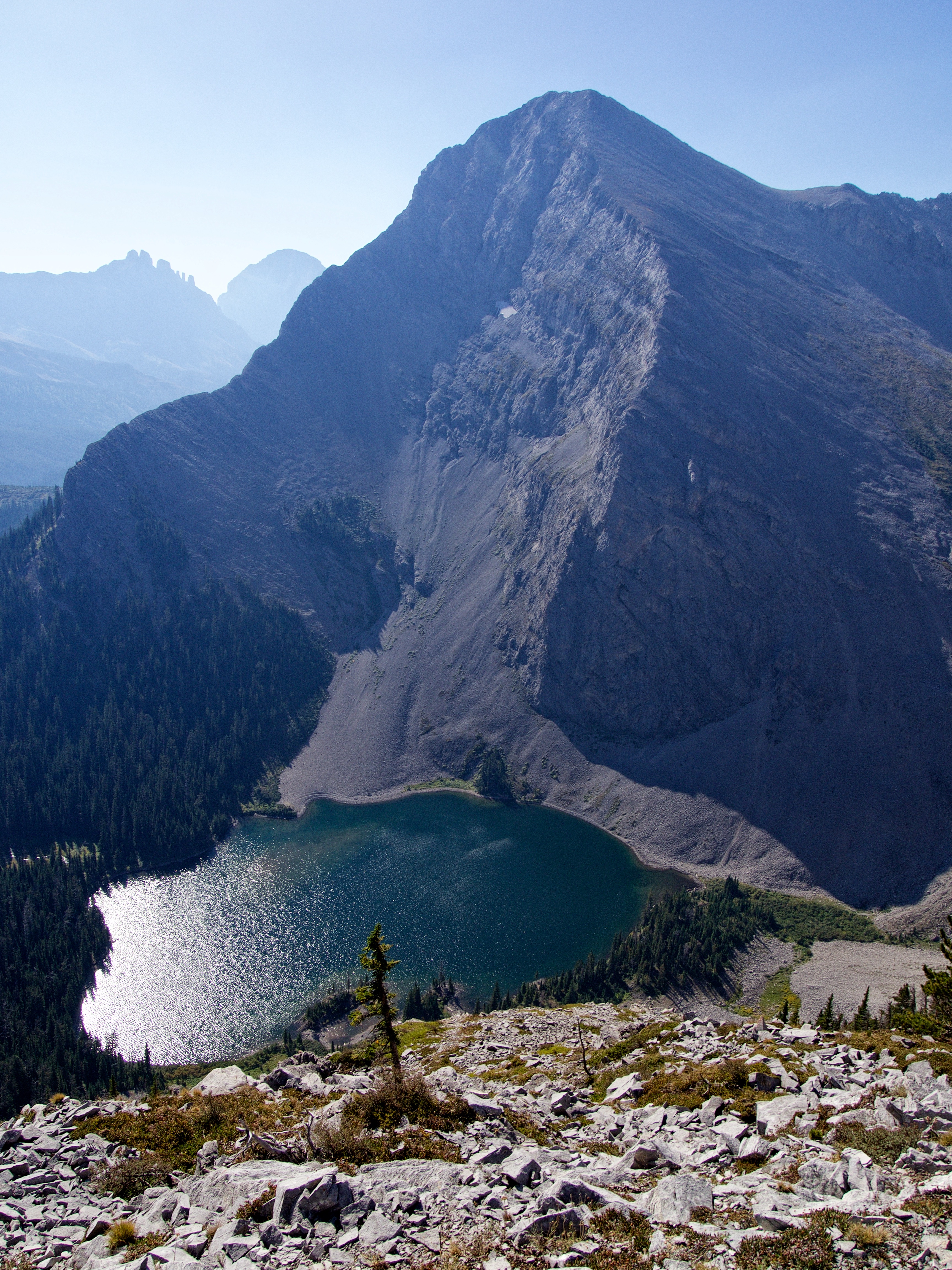
On the crest and looking at Window Mountain Lake and Mount Ward. The angle of the morning sun combined with the haze, washed out what would otherwise be a very pretty view.

This has to be a well-used route because it’s laid out so simply!

The usual approach follows the scree slopes in the centre of the picture. Mount Ward is on the left. (Photo by Mark Kadijk)

Looking across the valley at “Mount Racehorse” – where I was exactly one week ago.

Glancing back to where we gained the ridge (right).

We had no problem ascending past a couple of minor rock bands as we made our way up to the top of the first high point – an elevation gain of ~144 m from the col.

The views from the ridge commanded our attention all day long. (Photo by Mark Kadijk)

On top of the first highpoint. In the background is the connecting col with “Mount Racehorse”.

From the top, we discovered that a large cliff band guarded access to the remainder of the ridge. These cliffs extend almost to the col with “Mount Racehorse” and initially, we thought we would have to lose significant elevation in order to find a bypass. Fortunately, Mark discovered a way off the summit via a short, but exposed down-climb through a crack in the rocks (pictured next to Mark’s left foot).

A more comprehensive look at our route. For me, this was the crux of the entire trip and from this point on, travel along the ridge to the start of Kane’s scramble route was simply a hike.

Looking back at our route off the first highpoint.

A view from further back. The cliffs extend almost to the col (left) and what can’t be seen, are a second set of cliffs on the lower left. An alternate route to avoid any down-climbing, would be to follow the valley and ascend from the col, perhaps next to the cliffs.

With the crux behind us, it was now time to enjoy the rest of the ridge walk. (Photo by Mark Kadijk)

The ridge offers great views of Window Mountain Lake.

Mark enjoys the scenery to the west. I wonder how many people visit this valley?

Ascending past an impressive pinnacle. (Photo by Mark Kadijk)

A unique pattern on the rock that made it look like fossilized tree stump – maybe it was? Any geologists care to chime in?

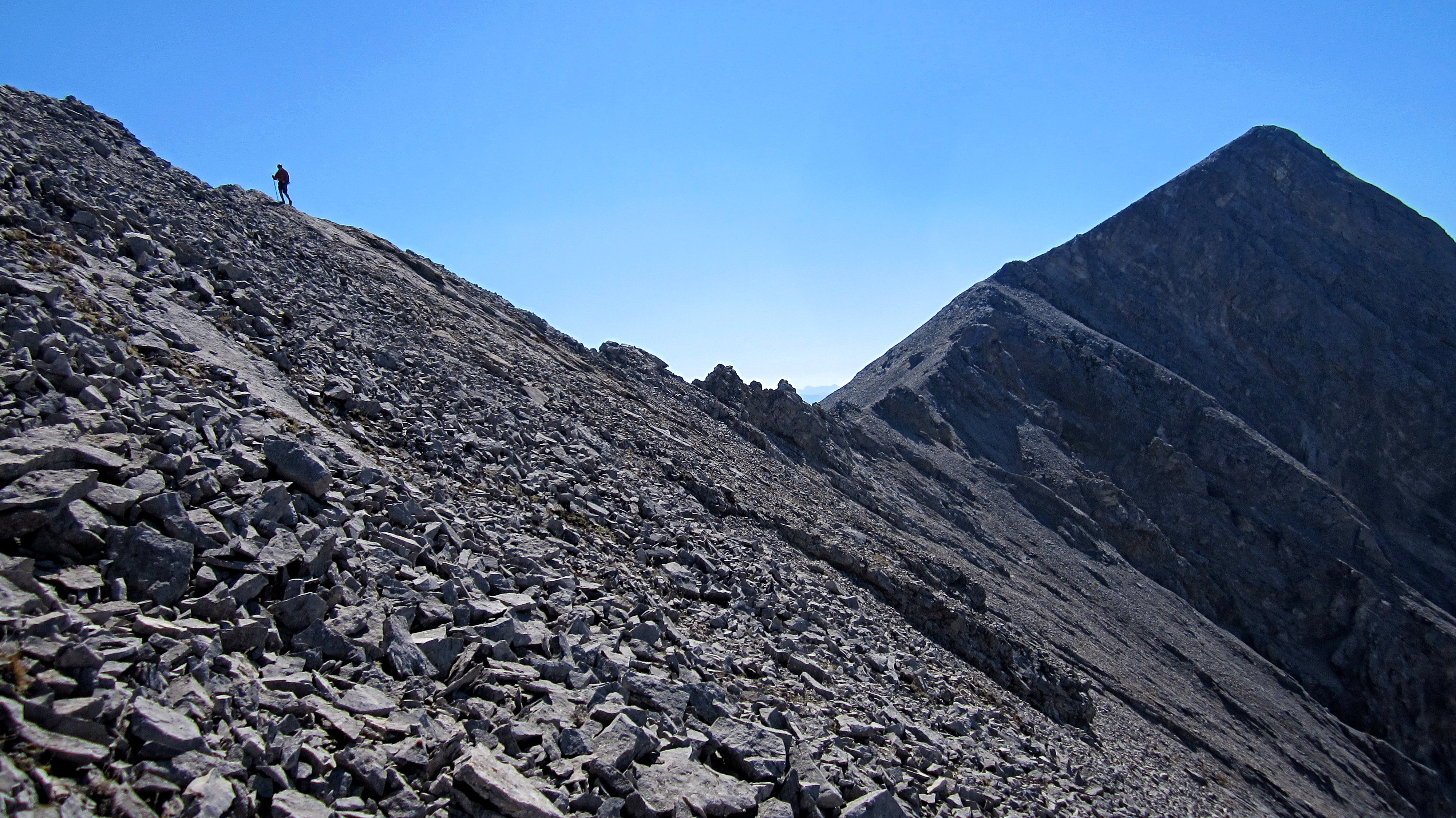
Gazing towards Mount Ward. The main concern along the ridge is paying attention to where you are in relation to the edge – particularly if it’s a windy day! (Photo by Mark Kadijk)

Looking back as Mark stops to take in the view. After losing ~ 30 m in elevation from the top of the first highpoint to a small col (pictured behind Mark), we would gain ~180 m in elevation over ~865 m to reach the top of intervening high point between Ward and Allison

The ridge offers some sweet views the surrounding area.

Looking across to Mount Ward from the top of intervening high point. At 2548 m, it’s only 22 m lower than the summit of Ward.

Window Mountain (foreground), Crowsnest Mountain, and the Seven Sisters.

Looking to the west at an unnamed lake and a small plateau.

The summit of Allison Peak and the connecting ridge. This is the beginning of the scrambling route described by Kane. A moderately worn trail leads across it, but we found it easier in many places to simply stick to scrambling the crest.

Looking back at Mark as he hikes up from the connecting ridge and onto the ridge leading to Allison Peak.

From the crest, we followed a trail that skirted climber’s left (southeast) and across a steep slope full of loose rock. (Photo by Mark Kadijk)

Outside of the down-climb earlier in the day, this section was probably the trickiest. The summit of Window Mountain is in the background.

After enduring ~200 m of tedious travel, we arrived on more stable terrain. From here it was a straightforward hike to the summit.

I’m calling this ‘Grizzly Rock’ because to me, it resembles the head, shoulder, and paw of a bear. Can you see it? Hint: the nose is on the right and the two ears are on top…

The impressive northwest face of Allison Peak.

The summit of Allison Peak (2645m).

Allison is one of the higher peaks in the area and its summit offers great views of the Crowsnest Pass. This is a pano to the southeast…

…to the southwest…

…to the northwest…

…and finally, to the north.

Mark plods up the final few metres to the summit.

Someone had left their thermometer behind, so I thought I’d check the temperature.

It’s always a pleasure to share a summit with Mark!

I’ve wanted to stand on this peak for many years! I celebrated by going full-on David Lee Roth! 😉

The Seven Sisters and Crowsnest Mountain.

In the foreground to the southeast are “Deadman Peak” and it’s twin. In the distance, Mount Coulthard, Mount Parrish, Andy Good Peak, Chinook Peak, Mount Ptolemy, and the Northwest Ridge of Ptolemy mark the northern end of the Flathead Range. Mount Tecumseh and Phillipps Peak are on the far right (middle distance).

Gazing slightly southwest at “Shooting Star Peak” and “Alexander Creek Mountain”.

Looking further to the southwest at the Natal Fire Lookout (left) and Mount Erickson.

The western ridge of Allison Peak.

To the north sits “Mount Racehorse” (left) and Racehorse Mountain (Peak).

Just like its eponym, Allison Peak also sports a “magnificent physique” – so much so, that Mount Ward (centre) and Window Mountain (right) are diminutive by comparison.

A telephoto to the northeast of “Vicary Creek Ridge”, Thunder Mountain, and “Lightning Peak”.

Kudos to whoever (Chad Helfenbein?) took the initiative to replace the original registry container with a Canada 150 Nalgene!

The summit registry is a bit of a ‘Who’s Who’ of mountaineering in Alberta. Alan Kane provided the first entry on September 11, 1993.

The late Rick Collier and his partner, Mardy Roberts.

Bob Spirko and Dinah Kruze.

Fellow Lethbian (yes, that’s what you call people from Lethbridge) James Yearous.

Andrew Nugara and Linda Breton.

The ubiquitous Kris Thorsteinsson.

I think Marko Stavric wins for best entry! I’m probably missing others such as Sonny Bou, Vern Dewit, and the many fearless leaders of Crowsnest Lake Bible Camp, but what stood out to me, is how few people have visited the summit even though it’s been in Kane’s book for close to 15 years. From the registry, it looks like traffic really began to increase after 2012 and judging by the number of entries, 2017 may well be the mountain’s busiest year. However, that number is still comparatively small with a quick (and I mean quick) guesstimate of less than 25 people so far this year.

I’m assuming that Chad Helfenbein is the selfless individual who forked out the dough to place the Canada 150 Nalgene on the top. Well done sir! And give that dog a bone too! Now here is where I have to admit that I never went to the Derek Zoolander Center For Children Who Can’t Read Good And Wanna Learn To Do Other Stuff Good Too, because it was only after I returned home, that I read Chad’s note on the bottom. Doh! We signed the new register and not the old one. If by chance you’re reading this Chad, please pardon my ineptitude!

Mark signs the new registry.

FYI, here’s what we wrote.

Maybe one day, someone will write that Mark and I were “still fairly well preserved” 😉

Leaving the summit.

Beneath the summit, we decided to try and skirt the ridge crest on the other side (northwest) in the hopes of avoiding the steep and slippery side-slope. Bad move! This side was even worse with more scree-on-slab crap. I quickly climbed up to the crest and this made travel easier, but Mark ventured quite a bit lower than me, before he too, had to climb up to the crest. In hindsight, it may have better to tackle the crest as close to head-on as possible.

Looking back at the summit as we descend to the connecting ridge with Mount Ward.

Someone had stacked these crystals next to a small cairn along the connecting ridge. We did not come across the window, nor ‘Crystal Cave’ where these come from because I had totally forgotten to look for them. To see the window and the cave, see Bob Spirko’s trip report.

Mark negotiates a narrow section on the connecting ridge.

Back on the ascent ridge and heading home.

I can’t get enough of those views! (Photo by Mark Kadijk)

The crux on the first high point proved to be much easier to ascend.

Looking down at Mark as he prepares to make the short climb up the crux.

One last look at Window Mountain Lake before descending into the valley. In the background is “Vicary Creek Ridge”.

Heading into the valley located between the ridge and “Mount Racehorse”.

Once on the trail, it was a quick and scenic hike of about 1 km to reach our bikes.

Enjoying the awesome ride back to Mark’s truck. The max speed that I hit was 43 km/hr – though to be fair, I did narrowly avoid a couple of epic wipeouts on the lower section of the trail where erosion had left some deep ruts and little room for error. Gotta love those disc brakes!

Arriving back at Mark’s truck after a roundtrip distance of 17.8 km and a time of 6 hours and 46 minutes. I’m sure many, many others have ascended using this route simply because it’s so inviting. I appreciated the more gradual elevation gains of the ridge versus bashing up a scree slope. However, if we didn’t have bikes, this route might have been too long to be so enjoyable. Finally, and as always, it was great to be out hiking – and solving complex theological issues 😉 – with Mark!


Leave a Reply