


⚠️ Hiking and scrambling are inherently dangerous activities. Please read my Disclaimer. ⚠️
Truth be told, I’d fixated on this unnamed outlier of Mount Tecumseh and Phillipps Peak for most of the winter. It doesn’t look like much from the south, but from all other directions it looked – at least to me 😉 – to be an intriguing objective. In particular, I thought that the northeast face, which is accessible via a cutline from Deadman Pass, might feature a scrambling route. I don’t know if this mountain has a local name – no one that I’ve talked to seems to know of one – so I coined it, “Alexander Creek Mountain” after the nearby creek and conservation lands. That being said, perhaps the Ktunaxa Nation on whose traditional lands it sits, have a name? If anyone knows of a name let me know and I will change my report to reflect it.
It had been a little over 2 months since I was last able to get out. End of semester busyness, a nagging cough, major hip surgery for my daughter followed closely by her high school graduation (Yikes! She’s my youngest!) meant a brief hiatus from hiking. As I was by myself and unsure of the snowpack on the northeast side of the mountain, I decided to ascend using what looked to be a decent but unglamorous approach from the south. Once on the summit, I could recon potential scrambling routes up the northeast face – which means that this might not be my only trip up “Alexander Creek Mountain”. 🙂 While it definitely looks like one could scramble up from Deadman Pass, the hiking route from the south was a fairly enjoyable experience that featured good views from the summit ridge.

“Alexander Creek Mountain” is located on the BC/AB border on the eastern edge of the Alexander Creek Conservation Lands and immediately south of Deadman Pass. More specifically it is situated within the triangle created by Mount Erickson, “Deadman Peak”, and the Tecumseh/Phillipps massif. Though really just an outlier, it intrigued me because it had enough separation from the massif to demarcate itself as its own unique destination.
My route approached it from south, though when I come back to scramble it, I will access it via a cutline that leads from Deadman Pass Trail (see my Deadman Peak report). To get to the southern route, I drove west from Lethbridge on Highway 3 until I crossed into BC. Approximately 1km west of the Crowsnest Park Provincial Park Rest Area, I turned into a weigh scale station on the righthand side of the highway. The access road for the Alexander Creek Conservation Lands begins inside the boundaries of the station. Motorized vehicle traffic is prohibited between April 1st and June 15th, so I biked the road for ~1.8km until I came to an old mining road that led north towards the southern end of the mountain. I then followed the mining road for an additional ~1.62km until I reached its terminus in a clearing beneath a small ridge that abuts against the mountain’s southern slopes.

After ditching my bike at the end of the road, I continued north by following animal trails through a section of small pine trees for ~300m until I began to lose elevation. Here, I again followed disappearing trails up through the trees for ~340m until I came across a superb animal trail that took me north and onto the crest of a little ridge. In total, I followed the trail for ~400m until it brought me to the edge of a steep gully / avalanche slope where the little ridge abuts the mountain. I then turned east to briefly descend and bushwhack across a ~100m section of deadfall to reach the southern slopes of the mountain. This is where it became a really steep hike!
Trending northeast, I slogged up open and lightly forested slopes for an additional ~420m until I came to the steep edge of yet another gully / avalanche slope. From here, I followed a myriad of animal trails east for ~170m to reach the crest of the southern ridge. Once on the crest, the grade eased and I enjoyed a pleasant ~330m hike to the summit ridge. The ~1.5km ridge walk to the summit was enjoyable and straightforward. After snapping some pics and then exploring the east ridge to recon a scramble route up the northeast face, I returned the same way.

According to Toporama, the last elevation line before the summit is 2320m. My GPS registered the summit at 2354m which sounds about right.

From my 4Runner to the summit it was 7.7km. My total distance travelled was ~15.8km with total elevations gain of 1175m. I was able to complete the entire trip in 5 hours and 14 minutes.

My starting point inside the weigh station boundary next to Highway 3. Though the access gate is open, motorized vehicles are prohibited on the road between April 1 and June 15. The summit of “Alexander Creek Mountain” is on the far right and like I mentioned before, it doesn’t look all that impressive from the south.

In 2013, Teck purchased 3098 hectares of land north of Highway 3 to create the privately managed, Alexander Creek Conservation Lands. Extending north from Phillipps Pass along the BC/AB border, this area has been deemed critical for wildlife connectivity, particularly “wide-ranging species such as grizzly bear and lynx” which use this corridor as a link to and from Waterton National Park. (source) Though the land is private, Teck does allow public access with the following proviso:
Please keep conservation in mind when you are enjoying recreation activities on these lands and respect the existing Access Management Areas on the Grave Prairie and Alexander Creek lands. (source & map)
Pictured above are the two signs found at the entrance to the Alexander Creek Conservation Lands. I contacted Teck to make sure that off-trail hiking was allowed and spoke directly to Kevin, their Environment and Landscape Conservation Manager. He confirmed to me that hiking is definitely allowed, but that random camping and off-road vehicle use were strictly prohibited. Kevin was incredibly helpful and his passion for the land was readily apparent. I really have to thank Teck for investing in, and setting these lands aside for conservation. If you happen to use this route, please make sure to respect all signage and as always, leave nothing but footprints.

Approximately 80m from the entrance gate, the road bifurcates with one branch veering sharply to the west while a second continues straight north (not pictured). This north road is the one I followed. Roughly ~500m from the gate, I came to a second fork (pictured) and a sign that read “Old Min” or mine. Kevin told me that this secondary road leads to an abandoned mine and though interesting, it wasn’t the road I wanted. Therefore, I continued straight along the main road.

It was a beautiful day and I thoroughly enjoyed the bike ride.

Approximately ~1.8km from the entrance gate, I came to a third fork in the road. This is where I left the main road to follow the old road that can be seen on the left.

Riding (and walking) down the old access road was a delight. The summit of “Alexander Creek Mountain” is to the right of centre and my ascent route followed the skyline slope that can been seen to the left of centre.

I came across some old core samples that were left beside the road.

The sample on the right seemed to be the best preserved.

The road continued north through sections of forest and meadow.

Approximately ~1.62km from its junction with the main road, the road came to an end at the edge of a large clearing. This is where I would ditch my bike and head into the small pine trees in the background.

Looking back down the road from its terminus. All three peaks (“Mummy Mountain”, “Anubis Peak”, and “Pharaoh’s Peak”) can be seen to the left on the Northwest Ridge of Ptolemy. Island Ridge is also on the left and Tent Mountain is on the right.

I followed a maze of disappearing animal trails as I made my way north from the clearing.

After ~300m I began to lose elevation so I knew it was time to begin my ascent of the small ridge that abuts against the mountain. The clearing where I left my bike can be seen through the trees on the left.

I trended in a northeast direction and whenever any real bushwhacking began, an animal trail would bail me out.

Approximately ~340m from where I left the section of small pine trees, I came across an amazing animal trail that would take me north and towards the crest of the abutting ridge.

After a while, the views from the trail began to open up and I could clearly see Mount Erickson.

On the crest of the little ridge. In total, I followed the easy trail for ~400m until I came to the edge of a steep gully / avalanche slope (not pictured).

Looking over at the steep slopes of “Alexander Creek Mountain” from the edge of the treed gully. I knew from my map that this was the point where the little ridge that I had been following intersected with the southwestern slope of the mountain. All I had to do was follow the edge of the gully to the northeast and I would be in good shape.

Reaching the actual mountain required me to briefly descend to the east and then ascend through a ~100m section of deadfall. However, I was once again assisted by an assortment of animal trails.

Once past the deadfall, I resumed my northeasterly direction. The picture belies it, but this is where it became a really steep hike.

I hiked across open slopes and through light forest until I came to the sharp edge of another gully / avalanche slope. I then followed the edge east for ~170m until I came to the crest of the mountain’s southern ridge. Again, there was no shortage of animal trails to help me out.

Finally on the crest of the southern ridge and looking east at the summit of “Shooting Star Peak”.

The grade became considerably more pleasant once I was on the crest.

The summit (centre) was still ~1.5km away from the top of the southern ridge.

At the top of the southern ridge, directly in the centre of a triangular formation of wooden slats, I found an old survey pin. An identical one exists directly to the east on “Shooting Star Peak”.

A close-up of the survey pin and tag. The one on “Shooting Star Peak” is 9374.

From the top of the ridge, I also got my first good view of Mount Tecumseh (distant centre) and Phillipps Peak (right). “Shooting Star Peak” is in the foreground centre.

The ridge walk to the summit was fun and relatively straightforward.

The only obstacle was a section of cliffs that I easily avoided by sticking to climber’s right.

Looking back at the section of cliffs that I avoided.

It was a simple hike to reach the summit (left). I would also explore the eastern ridge that can be seen on the right.

A pano to the south from along the ridge. Summit Lake is just to the right of centre.

The summit of “Alexander Creek Mountain” (2354m my GPS).

The summit sits on the BC/AB border and on the off chance that a roaming kleptomaniac happens to visit, a harsh warning is inscribed on the survey marker.

The views from the summit are really good in all directions. This is a pano slightly to the northeast.

This is a pano to the southeast.

Directly to the north are Allison Peak (left) and “Deadman Peak” (right).

The really fun ridge walk on “Deadman Peak” is in the foreground centre and in the distance are the Seven Sisters and Crowsnest Mountain.

The east ridge of “Alexander Creek Mountain” is in the foreground and in the distant centre is the South Peak of the Livingstone, followed by Morin Peak, Bluff Mountain and Turtle Mountain (far right).

I had great views of Mount Tecumseh (left), Phillipps Peak (right of centre) and “Shooting Star Peak” (in front of Phillipps) from the summit.

To the west sits Mount Erickson. The Alexander Creek Conservation Lands extend across the valley to its base.

Looking northwest at Erickson Ridge, Sheep Mountain, and Mount Salter. The land in the foreground of the valley constitute the northern edge of the Conservation Lands.

The view south includes Mount Ptolemy (far left) plus all 3 peaks on the Northwest Ridge of Ptolemy (NROP). As an aside, NROP is an awesome traverse! In the centre is Island Ridge, Tent Mountain, and Mount Taylor.

Looking southwest at Loop Ridge and the old Natal Fire Lookout. The tall peak in the distance on the right is the Three Sisters.

While the southern approach is gentle, the north face is rather steep. At the base is Deadman Pass.

A telephoto of The Seven Sisters and Crowsnest Mountain.

…and one last picture of the Tecumseh/Phillipps massif. Hopefully you can see my logic that while “Alexander Creek Mountain” is an outlier, it has enough separation to be clearly demarcated as its own little destination – at least that’s what I keep telling myself 😉

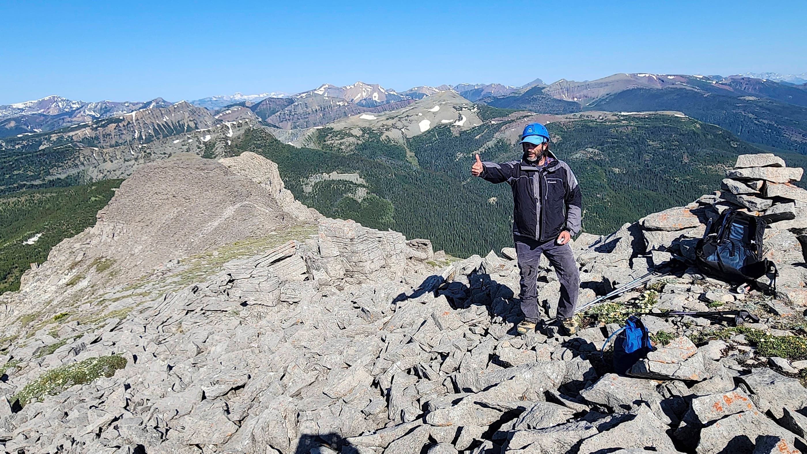
Old man selfie on the summit. With my youngest kid graduating from high school this year and my middle son getting married next year, I think my wife and I are moving into another phase of life… I believe it’s called senility.

After enjoying my time on the summit, I then proceeded to explore the east ridge and look for potential scrambling routes up from Deadman Pass.

Looking back at the summit and the mountain’s impressive north face.

The northeast face definitely holds some possibilities for scrambling. However, there is also a lot of slab & scree junk to deal with.

The end of the east ridge.

A clearly demarcated cutline extends from the base of the northeast face to Deadman Pass trail. When I return to attempt the scramble, I will bike in and then use the cutline.

A closer look at the northeast face. The east ridge curves down to meet the trees and it looks like it can be scrambled – but I won’t know that until I try it… but this is also the CNP and I’m sure it has been done many times by others!

After exploring the east ridge I bypassed the summit as I made my way back to the summit ridge.

This old tree had a “Day of the Triffids” vibe to it.

There were several rapidly melting cornices along the summit ridge.

One last look back at the summit.

Heading home through the forest.

These open slopes are much steeper than they look – but I think I said that already…

Back on that fabulous animal trail on the abutting ridge.

Apparently I didn’t make much of an effort to hide my bike… The awesome thing about having my bike was that I covered the ~3.4km back to my vehicle in only a matter of minutes. I don’t think I had to pedal once from when I got on it to when I arrived back at my 4Runner. Yee-haw!

Back at my trusty 4Runner after a good day of exploration. I’m not sure many people find obscure destinations like “Alexander Creek Mountain” as much fun as I do, but that’s okay because I’m a bit weird anyways. 😉 I doubt the summit sees much traffic, but I think this little mountain deserves some degree of homage. I’m now anxious to get out and attempt a scramble up its northeast face. Finally, as I mentioned before, no one that I’ve talked with knows of a local name for this mountain so I’m just using what I’ve coined for it – but that doesn’t mean one doesn’t exist. This is the CNP after all and everything has been explored many times over!

Leave a Reply