

⚠️ Hiking and scrambling are inherently dangerous activities. Please read my Disclaimer. ⚠️
As far as destinations in the Castle are concerned, Gladstone is intriguing because it’s really the culmination of a series of smaller, interconnected peaks that begin with Table Mountain. This makes the area an incredibly fun place to get up on a ridge and keep going for as little or as long as you’d like. I’ve wanted to visit Gladstone for many years, particularly after being thwarted on my first attempt back in 2015, settling instead for diminutive, “Mill Creek Peak”.
According to Dave Birrell in, 50 Roadside Panoramas in the Canadian Rockies, the mountain is named after William Shanks Gladstone who was born in Montreal in 1832. After joining the Hudson’s Bay Company at the age of 16, Gladstone spent five years “working at Rocky Mountain House in the winter and Fort Edmonton in the summer”. (144) Birrell notes that it was during this posting that Gladstone earned the nickname ‘Old Glad’ and in 1853, accompanied Father Lacombe to Fort Edmonton from York Factory.
Fort Edmonton is also where Gladstone married a Metis woman in 1855. However, “the girl was Roman Catholic and Father Lacombe wanted Gladstone to change his religion but he refused. The priest finally agreed to marry them but told Gladstone that he would not be able to wear his vestments during the service. ‘Old Glad’ is said to have replied, ‘I don’t care if you’re bare naked just as long as you marry us.’” (144) Gladstone’s wife would go on to save his life on two separate occasions. The first was “when he fell through the ice on a cold day” and the second was “when a prospector pulled a gun to shoot him, and Gladstone’s wife knocked it out of his hand with an axe.” (Peakfinder)
Of interest, is that Gladstone helped to build the whiskey trading post, Fort Hamilton (a.k.a. Fort Whoop Up) in 1870. (50 Roadside Panoramas in the Canadian Rockies, 144) Birrell states that Gladstone, “worked at the fort during the winters until 1874 when the arrival of the North West Mounted Police (NWMP) brought the end of the whiskey trade by the Americans.” (144) Following this, Gladstone ran a sawmill on nearby Gladstone Creek and sold lumber and other materials to the NWMP so they could build Fort Macleod. He lived in the Mill Creek Valley until his death in 1911 and in 1916, Mount Gladstone was named after him. (144)
Unlike my 2015 attempt, our route approached the mountain from the southwest via the summit of North Castle. Joining me was my friend Mark Kadijk, who unfortunately was battling inexplicable hip pain throughout the trip, and shortly after starting up the slopes of Gladstone, determined that he was in too much discomfort to continue. He then decided to wait for me back on the ridge to North Castle while I continued on to the summit of Gladstone. After I returned, we decided to forgo a possible trip to “Larry Mountain” and instead, returned the way we came. For me anyway, it ended up being a superb autumn hike and my hope is that Mark will heal up and be back on the mountain sooner rather than later!

I will save some space by deferring to my route description for North Castle. Otherwise, the summit of Gladstone is only ~2 km from the summit of North Castle, but the trip involves the moderate down-climbing of some intervening points along the connecting ridge, coupled with a ~78 m elevation loss to reach the col. The hike from the col to the summit is straightforward, involving a ~236 m elevation gain over ~1 km. After returning from the summit of Gladstone, we then scrambled back to the summit of North Castle and returned along our ascent route.

Including North Castle, our total distance travelled was 17.1 km with total elevation gains of 1356 m. Our roundtrip time was 7 hours and 8 minutes.

North Castle’s elevation is listed at 2332 m (Google Earth and Peakfinder) but Toporama shows the last contour line before the summit as 2280 m – which means that it can’t be higher than 2320 m. FYI, my GPS recorded the elevation as 2311 m. Similarly, Gladstone’s elevation is officially listed as 2370 m, but the last contour line before the summit is 2400 m. For what it’s worth, my GPS recorded the elevation as 2365 m.

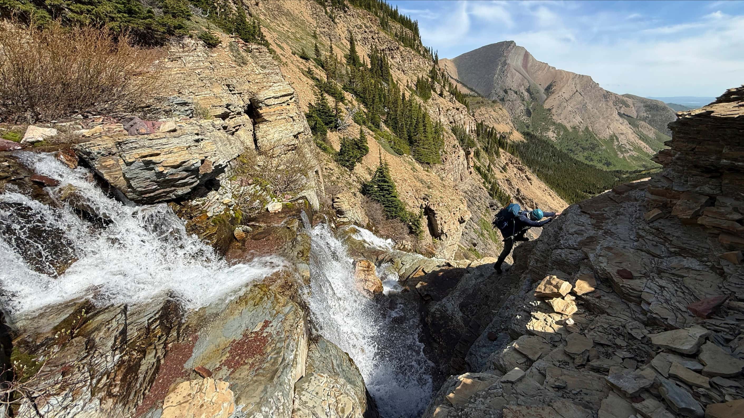
Leaving North Castle for Gladstone. The connecting ridge features a series of small cliff bands that require some moderate scrambling to negotiate. We would bypass the final point (left) on our way to the col, though I would ascend it on the way back.

Descending a small section of rock. (Photo by Mark Kadijk)

One last, minor down-climb. (Photo by Mark Kadijk)

Mark bypasses the final point before the col.

The hike from the col to the summit is easy, though it does require an elevation gain of ~236 m over ~1 km.

Starting up the slopes of Gladstone. “Frankie Peak” and “Larry Mountain” are in the background.

Victoria Peak and “Mill Creek Peak” provide a pleasant backdrop.

Mark had been battling hip pain throughout the trip, and shortly after starting up the slopes of Gladstone, he determined that he was in too much discomfort to continue. He encouraged me to go on while he returned to North Castle to wait for me.

Mark snapped this shot as he made his way back to North Castle while I continued up Gladstone. Can you see me in the top centre just to the left of the snow patch? (Photo by Mark Kadijk)

After a windy, but uncomplicated hike from the col, I could finally see the summit of Gladstone.

The cliffs beneath the summit are as striking as they are colourful.

The sun made an appearance at just the right time for me to capture some colour.

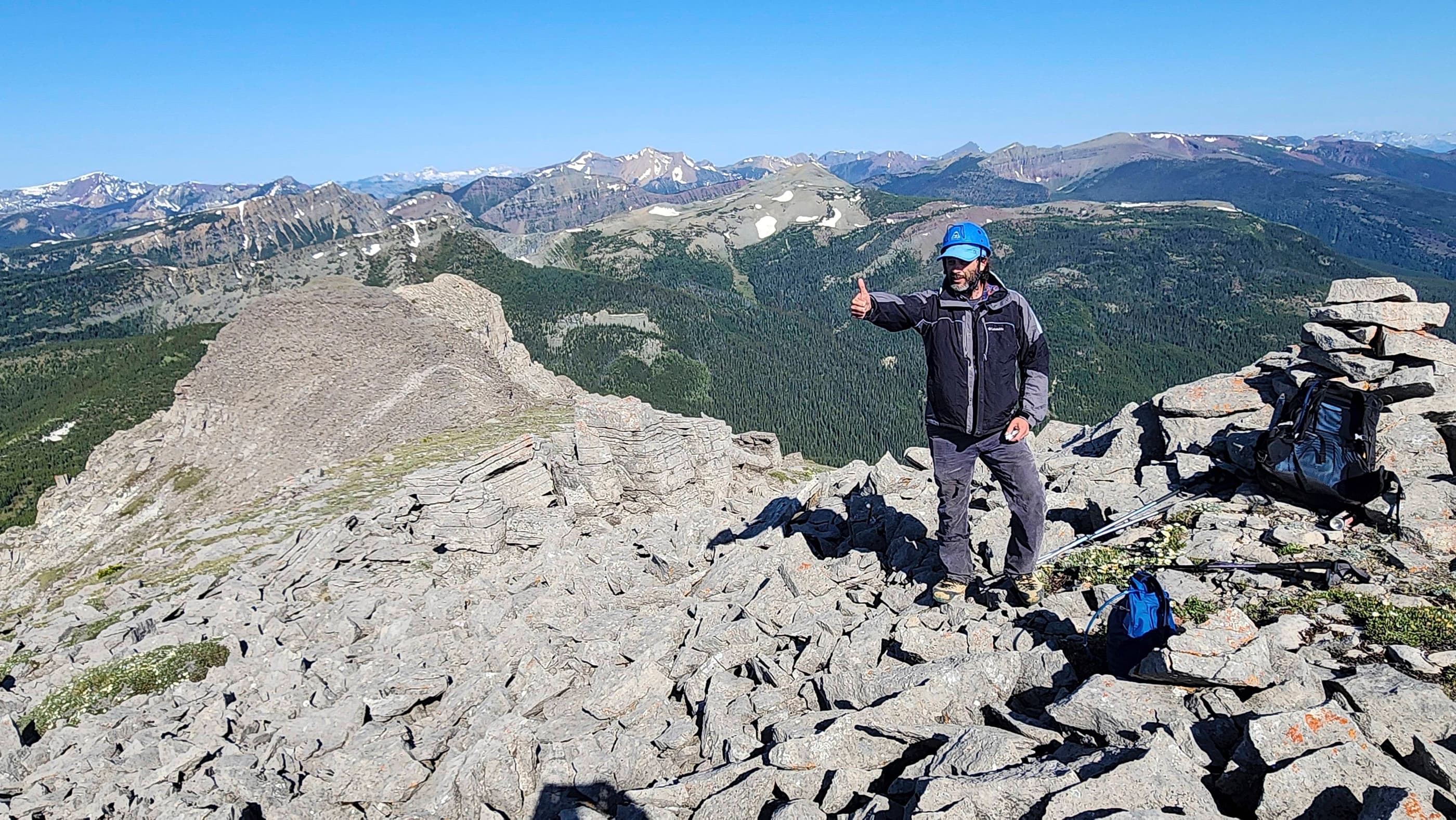
The summit of Mount Gladstone (2370m).

A small cairn sits on the summit but I couldn’t find a register.

A pano to the south.

A pano to the west.

The impressive north aspect of Gladstone. The small hills in the distance to the left of centre are Mount Baldy, Mount Albert, and Piney Point, while Christie Mine Ridge (which I’ve climbed but never posted a report) sits just to the right of centre. To the right of centre is “Whitney Creek Mountain” with Prairie Bluff on the far right.

Looking east at Prairie Bluff and Victoria Peak. Mill Creek can be seen in the foreground. The route described by Andrew Nugara in, More Scrambles in the Canadian Rockies, follows Mill Creek before branching off to follow the tributary (lower centre) that leads to southern slopes of Gladstone. This was the route that we followed in 2015.

The consolation from my 2015 attempt of Gladstone was “Mill Creek Peak” (foreground left). This ended up being a fun scramble and the right choice for the day, because as we were heading to the larger peak on the foreground centre, we were hit by a snowstorm that forced us to make a hasty retreat off the mountain. Had we been on Gladstone, we would’ve been stuck in deep snow and whiteout conditions. “Mill Creek Mountain” (foreground right of centre) is what I’ve named the entire massif and also the highest peak on it. In the distance to the southeast are: Victoria Peak (far left), Loaf Mountain (centre), Victoria Ridge (centre), and Windsor Mountain.

Windsor Mountain and Castle Peak dominate the view to the southwest while North Castle sits in the foreground on the right. In the distant centre are: Starvation Peak, Kenow Mountain, Jutland Mountain, and Langemarck Mountain. The summit of Lys Ridge is on the far right.

Another telephoto to the southwest of Lys Ridge (left), “Jake Smith Peak” (centre), Rainy Ridge (right of centre), Three Lakes Ridge (right of centre), and West Castle (right).

And yet another telephoto to the southwest that highlights Mount Haig and Barnaby Ridge (both on the right).

A telephoto to the northwest includes “Eagle Peak”, “Whistable 1”, and “Table Top” in the foreground. In the background from left to right are: Syncline Mountain, Mount McCarty, Centre Peak, Mount Darrah, Mount Pengelly, Mount McGladrey, Mount Ptolemy, and Mount Coulthard. The small, nondescript bump sitting middle distance on the far right is mighty Cherry Hill.

Looking to the north at the summit of Table Mountain (left). Behind it in the distance are Hillcrest Mountain, Turtle Mountain, and Bluff Mountain. The small bumps in the centre include some great snowshoe destinations. They are: Mount Backus, “Blue Mountain”, Burmis Mountain, Byron Hill, Tallon Peak, and Robertson Peak. “Gladstone’s Toe” a.k.a the far north ridge of Gladstone is on the right.

Summit selfie in front of “Larry Mountain” and “Frankie Peak”.

Time to head back to North Castle and see how Mark is doing…

Mark waits for me on top of a point (right) between Gladstone and North Castle.

Gazing down the connecting ridge with “Larry Mountain” and “Frankie Peak”.

A silhouette of Mark’s head and shoulders can be seen poking over the top of the point. As far as scrambling goes, this was the biggest section of rock that we encountered.

After reconnecting with Mark, we began to head back to the summit of North Castle (right).

Another section of scrambling.

Regaining North Castle’s summit ridge.

I didn’t get a summit picture on North Castle earlier in the day, so I stopped for one on the way back. Does this count as my third summit? 😉

Outside of the actual summit, North Castle provides some great views. Lys Ridge is in the background.

This vantage of Windsor Mountain and Castle Peak is still my favourite.

What a gorgeous day!

Heading down the ridge to the grassy patch in the centre.

Mark takes in the views of Barnaby Ridge and Southfork Mountain.

Our route retraced our steps down the grassy slopes and into the trees to the right of centre.

After the wind that I encountered on Gladstone, it was nice to get onto the more protected slopes of North Castle.

We followed the open slopes as far as we could before entering the trees.

The second large hole that we came across on North Castle. Thankfully nobody was home… but who knows, maybe this, and not the other hole, is actually the Cave of Caerbannog? 😉

Argh! Back into the deadfall.

For some reason, the act of picking our way through ~500 m of deadfall was not as tolerable in the afternoon as it was in the morning. 😉 After what seemed like an eternity, we finally arrived at the South Castle Road.

The ~2 km ride back to my 4Runner was however, an enjoyable way to end the day.

Mark rides across the newly repaired section of road. The last few times that I’ve been here, this section has been largely impassable to vehicles because it had been washed out by the creek. However, the recent Kenow and Castle Branch wildfires necessitated that the road be repaired so that firefighting equipment could be brought in. At some point in the near future though, most of the South Castle Road will be closed to motorized vehicles anyways, so I don’t feel too bad about not driving to the trailhead.
This ended up being a great day for me, but probably not for Mark who struggled with an unknown hip ailment. Hopefully he can get a diagnosis and a treatment plan soon! If I were to do this again, I might think about going even further down the road before leaving it to hike up North Castle. The advantage of this would be a possible avoidance of the deadfall and a chance to reach the open slopes sooner. However, it would also be a steeper approach as it would not follow the more gradual contours of the ridge that leads up from the creek.
As for Gladstone, I liked this approach better than the route up Mill Creek, but hey, it’s really six of one and a half dozen of the other. I’m just glad that I was finally able to make it to the top and enjoy the views. Now I just have to visit “Larry Mountain”… 🙂

Leave a Reply