⚠️ Hiking and scrambling are inherently dangerous activities. Please read my Disclaimer. ⚠️
To be honest, Buchanan Peak doesn’t look like much from the summit of Buchanan Ridge. The other unnamed peaks on Buchanan Ridge are way more impressive – unless of course, you take the time to view Buchanan from a northeast vantage along the Carthew-Alderson trail. From here, it looks altogether more stately. However, I’m still baffled by this one.
So why is both this peak and the ridge named for William Ashbury Buchanan? According to the Waterton Lakes National Park publication, “Senator Buchanan Winter Sports Competition”, Buchanan – who was the founder and editor of the Lethbridge Herald – “had a keen interest in the park and was its most influential supporter taking an interest in everything ‘Waterton’ even from his office across the country in Ottawa.” Indeed, it was Buchanan who garnered support to create the Waterton-Glacier International Peace Park, the first of its kind in the world (Ibid). Known as the”Senator from Waterton Lakes National Park” (Ibid) , Buchanan was also responsible for lending his support to the creation of a fish hatchery that opened in 1928. (Where the Mountains Meet the Prairies: A History of Waterton Lakes National Park by Graham A. Macdonald, 58) As MacDonald notes, this hatchery was important, because the natural fish stocks had been ravaged, with “some parties having been recorded taking 500 fish in one day.” (Ibid, 57) Thus, as far as relevant mountain names go, Buchanan is a worthy choice for this massif.
As for the route to Buchanan Peak, it ended up being a quick scramble from the summit of Buchanan Ridge, with lots of options to avoid down-climbing by keeping to skier’s right. However, we opted to stick close to the crest where we were treated to some interesting and colourful sections of argillite. After partaking of the hazy views, we opted to descend into the gorgeous valley immediately to the south, where we found yet another cool waterfall. We then joined up with the Carthew-Alderson trail – made a brief visit to the lowest Carthew Lake and then Alderson Lake – before enjoying the easy downhill hike back to my car in the Waterton Townsite. All in all, this was a great trip that once again, had me laughing and smiling throughout the day. 😁 Thanks Andrew!
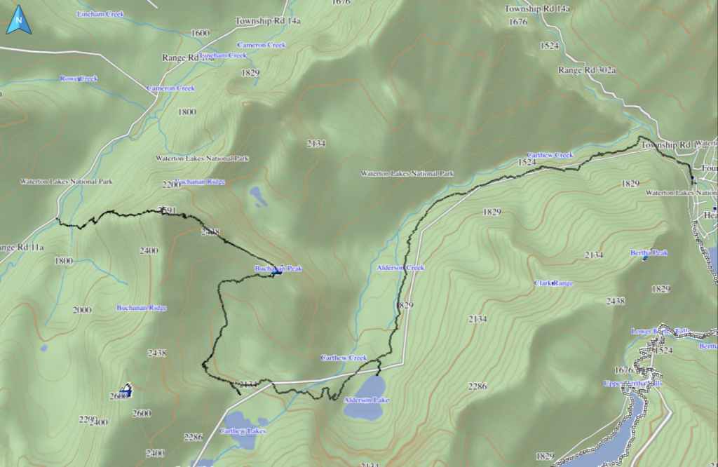
Buchanan Ridge and Buchanan Peak are included in Alan Kane’s, Scrambles in the Canadian Rockies, as add-ons to Mount Carthew. We used a two-vehicle route that was a variation of Andrew’s August 2005 and December 2020 routes, where we ascended the same way, but chose to descend into the large valley immediately to the south of Buchanan Peak and then out along the Carthew-Alderson trail.
Our day began by leaving my vehicle at the Carthew-Alderson trailhead in the Waterton townsite. We then used Andrew’s car to follow the Akamina Parkway to the Rowe Lakes trailhead. From here, we continued driving for another ~1.6 km until we came to a small pullout on our right that was immediately across the road from the 12 km marker post. This was our starting point.
After crossing Cameron Creek, we began the steep climb up the west ridge immediately beneath the summit of Buchanan Ridge. The route was incredibly straightforward and the only scrambling we encountered, was what we chose to do. From the car to the summit, it was a very quick 2 hours and 20 minutes with an elevation gain of 991 m over 3.6 km. From here, the remainder of the route was downhill.
Getting to Buchanan Peak involved a fun, ~2 km scramble along the connecting ridge, with many of the down-climbs avoidable by sticking to skier’s right. We arrived on the summit a mere 1 hour and 15 minutes after leaving the summit of Buchanan Ridge. Though we debated using Bob Spirko’s 2005 route to reach the trail, we ultimately decided to explore the lush valley immediately to the south. As we wanted to visit the lowest Carthew Lake, we trended along the upper reaches of the valley beneath Carthew, until we reached the Carthew-Alderson trail.
After a quick visit to the lake, we began to head back along the trail, again stopping briefly on the shores of Alderson Lake to eat our lunch. From Alderson Lake, it was an easy 6.8 km hike to the Waterton townsite and my vehicle.
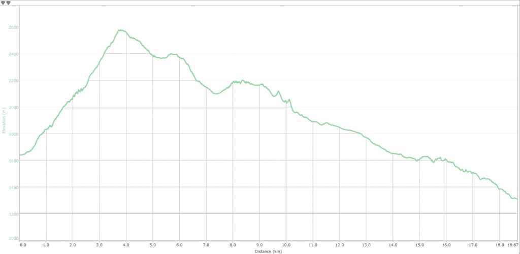
Our total distance travelled was 17.7 km with a total elevation gain of 1261 m. Our total roundtrip time was 7 hours and 33 minutes.
Looking back to the cairn on Buchanan Ridge.
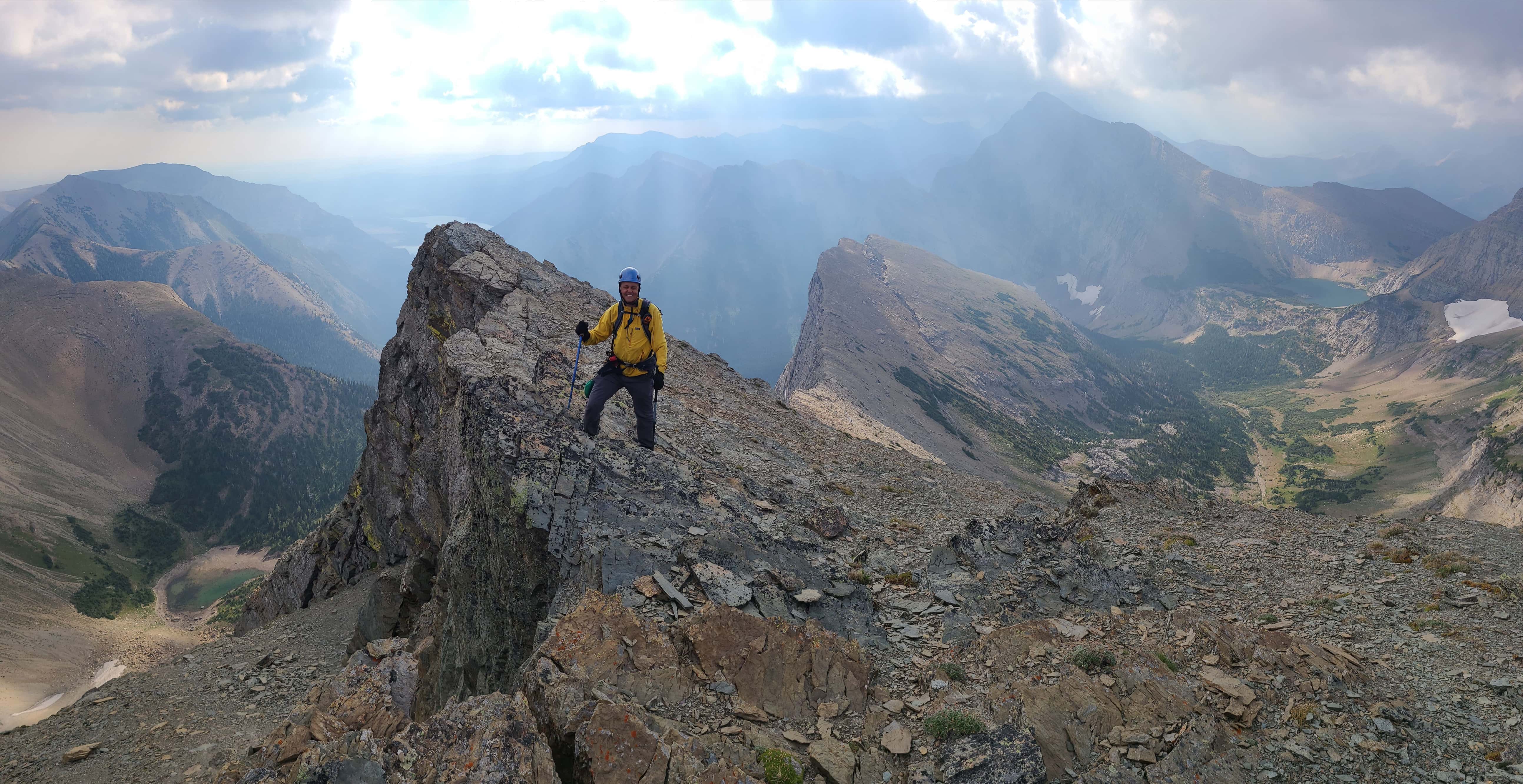
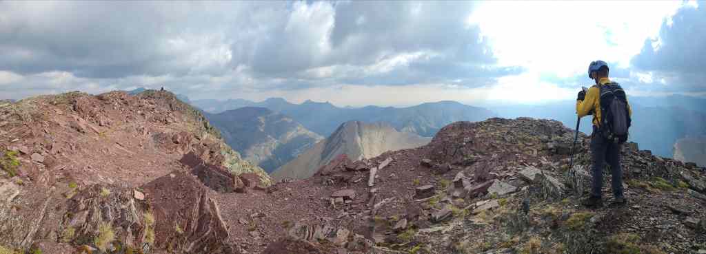
Heavenly light shines on Buchanan Peak as Andrew leads the way.

A pano of the previous photo. Though the scene would be much better under sunny skies, the dark clouds and partial sunlight provided some neat atmospherics.

We stuck to the crest as much as possible, though there was always an out to skier’s right.

The first of many examples of ripple-marked rock.

This was an impressive slab of ripple-marked argillite.

The obligatory lichen-on-argillite photo. 😁

Andrew descends near a colourful chunk of argillite. Given the size of the crack, I would guess that at some point, the whole thing is going to give way and plummet to the valley below. Better get a move on Andrew! 😂

Andrew’s yellow jacket lures more lichen-covered argillite into the open. 😂

A broader view of the previous photo coupled with some down-climbing.

This moss pattern reminded me of a cartoon chimp… or a bear with a perm. I can’t decide…

Andrew enjoys his time among the argillite. 😂

The summit is getting closer…

Andrew opts not to try this diving board into the afterlife. 😂

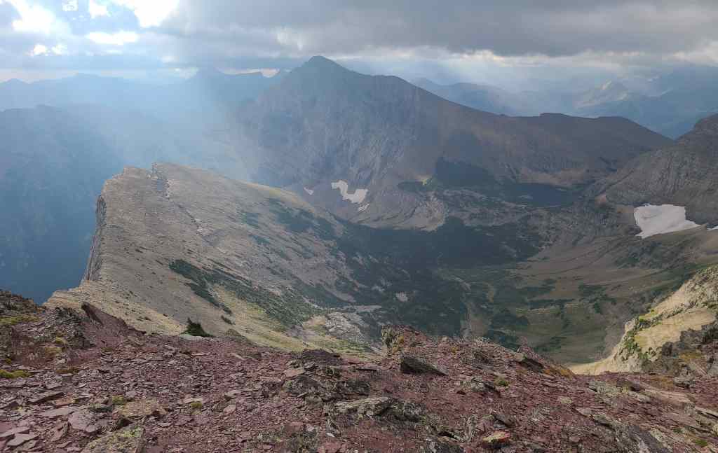
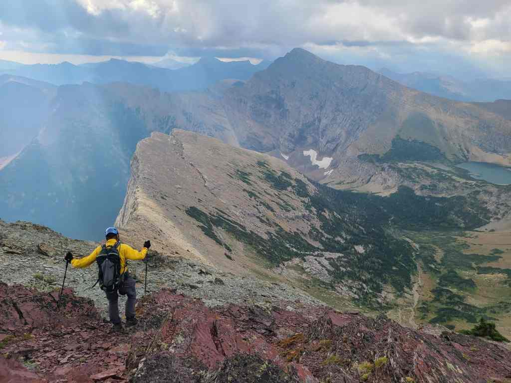
A better look at the tarns beneath, “The Senator”.

Hmmm, I think I should probably lean in the opposite direction next time…. 😳 (Photo by Andrew Nugara)

Lots of interesting terrain.

Looking back to the summit of Buchanan Ridge.

More views toward “Senator Peak”.

A dark cloud momentarily suppresses the sun.

Glancing back from the col.

Strong gusts would force us to stay well-back of the edge.

The sun is back!

The summit of Buchanan Peak (2416 m). It only took us 1 and 15 minutes to get here from Buchanan Ridge.

A pano to the south…

And to the west.

Looking north…

And finally, to the east.

Looking across the valley to Bertha Peak (left) and Mount Alderson (right).

A closer look at Mount Alderson.

Gazing across to Mount Carthew. We will eventually descend into the intervening valley.

We finally get a glimpse of the middle Carthew Lake (right of centre).

Andrew chillin’ on the summit. 😁

Me trying to keep my balance during a gust. 😂 (Photo by Andrew Nugara)

We debated using Bob Spirko’s 2005 route to descend, but ultimately, we wanted to visit the lower Carthew Lake and cutting across the valley would save us from having to regain elevation. Besides, Andrew has never been in this valley before, and anytime that I can find a spot in Waterton where he hasn’t been, I feel better making him repeat summits. 😁

There is a massive fissure on the side of Buchanan Peak…

So naturally, we wanted to explore it. 😁 (Photo by Andrew Nugara)

Inside the fissure. It feels awkward to even say that out loud… 😳

Looking towards Buchanan Ridge. The rock inside was quite unstable…

Except for this massive slab that had wedged itself in the middle.

Andrew’s view from the previous photo. (Photo by Andrew Nugara)

Continuing our way down to the valley.

Our route would go underneath the snow patch on the left.

Thankfully, there were plenty of open sections and there was no need to bushwhack.

At this point we were being mocked by a particularly large and an obnoxious marmot. 😂

This is a gorgeous locale!

A goat trail will eventually take us across the cliffs on the right, where we would meet up with the Carthew-Alderson trail.

I think Andrew is trying to tell me something… 😂

We lucked into a clear path through the krummholz. Every time I see or hear this word, I feel like it should be yelled, simply because it’s German. 😂

Andrew spots some movement on the slope above. An angry German perhaps…?

Nope. Just some goats who could care less about us.

Arriving beneath the snow patch.

This would end up being another of the many cool waterfalls we came across.

Andrew takes time to compose the perfect, slow shutter photo.

I however, did not take the perfect, slow shutter photo. 😂

I’m cheering that the snow will make it into winter, but with the heat we’ve been having, I highly doubt it.

We found a nice goat path across the lower section of these cliffs.

A second stream from the same snow patch, made for yet another cool waterfall.

Traversing across the cliffs.

Our first glimpse of Alderson Lake.

Looking back to Buchanan Ridge (centre) and Buchanan Peak (right).

The goat trail led us right onto the Carthew-Alderson trail.

Once on the trail, it was a short hike to the lower of the three Carthew Lakes.

Arriving at the lake. (Photo by Andrew Nugara)

All three lakes are very scenic and worth visiting.

Gazing back to where we came from. Yes, it would’ve been much, much quicker to regain the elevation back to Buchanan Ridge and then descend back to Andrew’s car, but this route was way more scenic – and it was almost all downhill.

Back on the trail and heading to Alderson Lake.

I had forgotten how pretty this trail is!

This waterfall is more impressive earlier in the year, but it’s still cool.

Drawing closer to Alderson Lake.

Looking down the valley. (Photo by Andrew Nugara)

Passing by Buchanan Peak.

A final look at Mount Carthew.

We decided to stop for lunch at Alderson Lake.

A fine place to relax.

Back on the trail and making quick work of the 6.8 km hike to my car.

A view of Buchanan Peak from the trail. This is where it looks more stately.

A better view of Buchanan Peak (left) and Buchanan Ridge (right).

Easy travel.

Crossing a near-empty drainage.

The lower section of trail was scorched during the 2017 Kenow wildfire.

Andrew passes the start of our ascent route for Bertha Peak.

This drainage proved to be a great way to get onto Bertha Peak!

Andrew almost disappears as he walks through a dense patch of thimbleberry.

A quick view back.

Wow! The smoke had cleared considerably since we started. We could now get a good look at Mount Crandell…

Along with Vimy Peak.

An even better look at Vimy.

Getting close to Cameron Falls…

Arriving at the Carthew-Alderson trailhead – and my car – after 17.7 km over 7 hours and 33 minutes. Crap! I just remembered that I left my keys in Andrew’s car… 😂 Just kidding, though it never hurts to carry a spare set. Well, after years of constantly being thwarted by weather, I finally made it onto both Buchanan Ridge and Buchanan Peak. Now I’m looking forward to coming back for “Buchanan, The Middle Child” and the northeast peak, weather permitting… As per usual, today was a gift and a huge thanks to Andrew for suggesting the two-vehicle route!


Leave a Reply