
⚠️ Hiking and scrambling are inherently dangerous activities. Please read my Disclaimer. ⚠️
On the margins of a good weekend forecast, Brad and I headed out to try for a late day summit in Waterton. Unfortunately, the transition into great weekend weather meant for an unstable air mass that was accompanied by a wickedly strong and biting wind. This forced us to find an objective that would provide us with decent shelter on ascent and hopefully the ability to stand upright on the summit. 😳 Though we contemplated Buchanan Ridge, we quickly changed our minds when we pulled into the parking area and found we could barely open our doors due to the intensity of the wind. That’s when Brad suggested, Lion’s Head, a small, officially named summit that I’d never heard of before today.
Where is Lion’s Head you ask? 🤔 It’s a prominent spur located on the northeast ridge of Vimy Peak that’s not often labelled on modern maps. However, as Brad observes, it’s a feature on many older Waterton maps and is included among the repertoire of local hikes. The Alpine Stables in Waterton also offer it as a 4 hour pack trip. Thus, while Brad had previously ascended Vimy, Lion’s Head remained on his ‘To Do’ list and I was more than happy to oblige crossing it off his list. That it would offer some semblance of shelter on approach was an added bonus.
As we had started late in the morning, we weren’t anticipating a long approach and though it’s my general rule in the Castle and Crowsnest Pass to bring a bike, neither of us had thought to do so today. Indeed, the ~6.5 km flat section between the Wishbone trailhead and its junction with the Vimy Peak trail is ideally suited for bikes – and is one of the few trails in Waterton where they are allowed. However, due to the friendly terrain and fantastic scenery, it ended up being a pleasant walk that we both enjoyed.
With the strong wind coupled with on-again-off-again snow and rain, we also weren’t planning on going beyond the summit of Lion’s Head. In fact, our time on top was punctuated by a snow squall. However, the lure of continuing on was too strong to resist. I mean, if we had come this far, why not keep going? 😁
As Lion’s Head is not part of the Vimy Peak trail and since the northeast ridge looked like an inviting route, we simply followed it all the way to the summit – a distance just over ~2 km. Besides, after encountering numerous trees across the trail and noting that the upper section of trail was covered in deep snow, sticking to the ridge could help us avoid what looked to be tedious and potentially torturous travel.
Indeed, aside from a couple short sections of bushwhacking, the ridge proved to be a wise choice and we arrived on the snow-capped summit under an increasingly clear sky; rewarding our efforts with fantastic views. As time was ticking and we had a lengthy walk back, we lingered just long enough to snap a few photos before following our route back to Lion’s Head and then the trail.
For a trip that started with the sole intent of avoiding the wind, unexpectedly tagging two summits including a prominent peak, made this into an incredible day of scenery and companionship. Over the years, “Always bet on Brad” has become my steadfast mountain mantra and today was no exception. Thanks Brad! 😁
Edit May 2022: Recent scholarship by Dr. Ninna Piiksii (Mike Bruised Head / Chief Bird) has uncovered that the Blackfoot name for Vimy Peak is Saakiihmabii or, ‘One who sits across the water’. Mike has determined that Lion’s Head should more properly be referred to as Oomhkataiyoo, which means ‘cougar’ in Blackfoot.
Edit June 2024: Ninna Piiksii along with the Crow Chief family and Parks Canada officials, led a ceremony on Indigenous Day on 21 June 2023 to gift second name to the mountain. This new name is, Maisstooinastáko (Crow Chief Mountain), after Joe Crow Chief of the Kainai Nation for his bravery in single-handedly capturing a German trench during the Battle of Vimy Ridge. (source; source; source) Moreover, this name encompasses the “entire Vimy Ridge Mountain including Vimy Peak”. (source) Thus, the national achievement for which the massif was given its colonial name, has been further localized in a very meaningful way. That it directly ties into both the Siksikaitsitapi belief that the mountain is sacred and that it reflects the heroism of a local Kainai soldier, is ever so fitting.

An older map of Waterton that Brad uses to manually track his trips. Note the upper centre portion where Lion’s Head is labelled as a feature on the northeast ridge of Vimy. Many of the newer maps do not include this. (Photo by Brad Wolcott)

Routes up Vimy Peak are aptly described in Andrew Nugara’s, More Scrambles in the Canadian Rockies, and both the Wishbone and Vimy Peak trails are highlighted on Park maps. I will note, that the Vimy Peak trail does not extend all the way to the summit, making the 4.8 km indicated on the junction sign, a misnomer. In fact, someone had tried to scratch it off, perhaps after their day was longer than expected.
To get to Lion’s Head, we hiked the Wishbone trail for ~6.5 km to the junction with Vimy Peak trail. Note that there is an unbridged crossing of Sofa Creek ~4 km from the trailhead, so be prepared for high water depending on the time of year.
From the junction, we then ascended the Vimy Peak trail for ~3 km until we came to a small clearing where Lion’s Head was directly in front of us. We located a subsidiary trail on the right that led down and across a small creek before heading up to Lion’s Head. Getting onto the top required a short scramble.
Even though we could have returned to the main trail, we continued to follow the northeast ridge for ~2 km to reach the summit of Vimy Peak. Along the way, we encountered a few sections of class 3 scrambling. Due to snow on the upper section of the trail, we returned along the northeast ridge.

Our total distance travelled was ~28 km (I forgot to start my GPS until ~683 m into the hike) with total elevation gains of 1369 m. The elevation gain from Lion’s Head to Vimy Peak is 558 m over ~2 km via the northeast ridge. Our total roundtrip time was 9 hours on the nose.
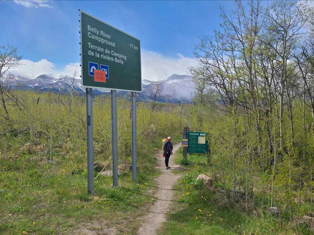
The Wishbone trailhead is located on the Chief Mountain Highway, ~488 m from the junction with Highway 5.

The trailhead sign. This area is prime bear habitat, so be prepared to make plenty of noise while you hike or cycle.

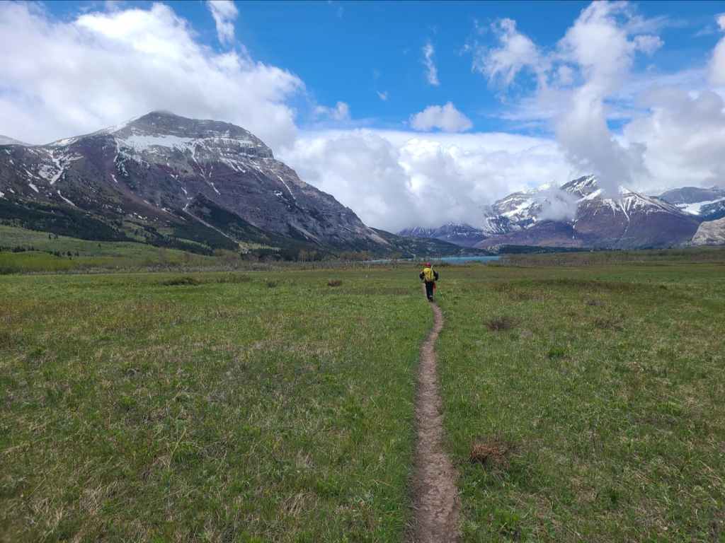
Brad enjoys easy travel along the trail. Sofa Mountain is on the left and Vimy Peak is on the right.

The trail alternates between wide open spaces and stands of aspen and alder.

Vimy begins to disappear as snow and rain move in.

Approaching the unbridged crossing of Sofa Creek approximately 4 km from the trailhead.

The water level and current may fluctuate depending on the time of year. Today it was calf-deep and quite swift – and cold – really cold! In fact, one might say that Sofa Creek was Sofa King cold! 😬

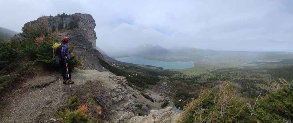
Gazing along Sofa Creek towards Mount Crandell.

I make a graceful crossing. 😂 (Photo by Brad Wolcott)

I absolutely love the scenery on this trail.
Clear skies again over Vimy (right) – at least for now!

Mount Crandell is directly in front of Brad with Bertha Peak on the left.

Our first good look at Lion’s Head (left) from the trail.

Approximately ~6.5 km after starting, we arrived at the junction with the Vimy Peak trail. In the background, Lion’s Head makes an appealing case for ascent.

The actual trail does not lead to the summit and so the 4.8 km is a bit of a misnomer. Someone had expressed their displeasure with this by trying to scratch the distance off of the sign.

On the Vimy Peak trail with Lion’s Head on the left and Vimy Peak on the right. At this point, we were not planning to ascend Vimy.

A closer look at Lion’s Head (left) and the northeast ridge of Vimy.

The trail maintains an enjoyable grade as it gains elevation.

Lion’s Head rises in front of Brad.

Winter winds and heavy snow left numerous trees across the trail.

Brad avoids yet another fallen tree.

Approximately 3 km from the junction, we came to the short trail that leads to Lion’s Head (centre).

In this photo, I am looking back along the main trail as Brad leaves it to follow the Lion’s Head trail.

Crossing makeshift bridge over a small stream.
The trail emerges onto the crest of the northeast ridge.

Heading towards Lion’s Head.

I have no idea why it is called Lion’s Head. I myself, see a gorilla’s face from this angle…

And then as we get closer, a wolf’s head (note the ear at the top with the eye below it to the right and the snout jutting skyline). Maybe this is the lion’s head?

It’s only a short scramble to reach the top.

The summit of Lion’s Head (1753 m).

A pano along the ridge to Vimy (right)

Looking onto Middle Waterton Lake.

The view to the northeast.
A 360 video from the summit.

Lion’s Head was yet another great suggestion by Brad! 😁

One of my less awkward summit photos, though I look like I’m about to engage in a gunfight at the OK Corral. 😂

Despite the inclement weather, we couldn’t resist following the ridge towards Vimy. 😁

Looking back at Lion’s Head and Sofa Mountain (right).

To avoid snow along the crest, we traversed beneath the trees before ascending the highpoint in the centre.

This decision led to some great views!

Aside from two short sections of bushwhacking, we made quick time across the slope.

A herd of sheep (left) graze peacefully on the ridge.

Sheep are ‘ewebiquitous’ on this mountain! 😂😂

Crossing a small waterfall beneath the highpoint. (Photo by Brad Wolcott)

‘Ruffy’ the ruffed grouse.

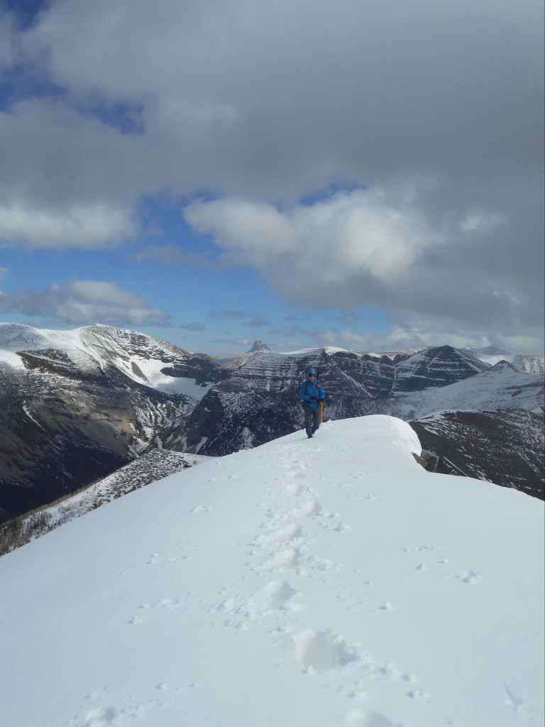
Ascending the highpoint.

Gazing back along the ridge.

Thankfully, the snow was firm enough to support our weight – well, Brad’s anyway. 😂

Brad surveys the route to the summit. Those upper slopes are steeper than they look!

More great views!

Brad leans into the increasingly steep terrain.

We are being watched… 😳

“Ewereaka!” More sheep!

My view over to Brad…

And his view back to me. (Photo by Brad Wolcott)

Lion’s Head (centre) looks kitten-like from this height.

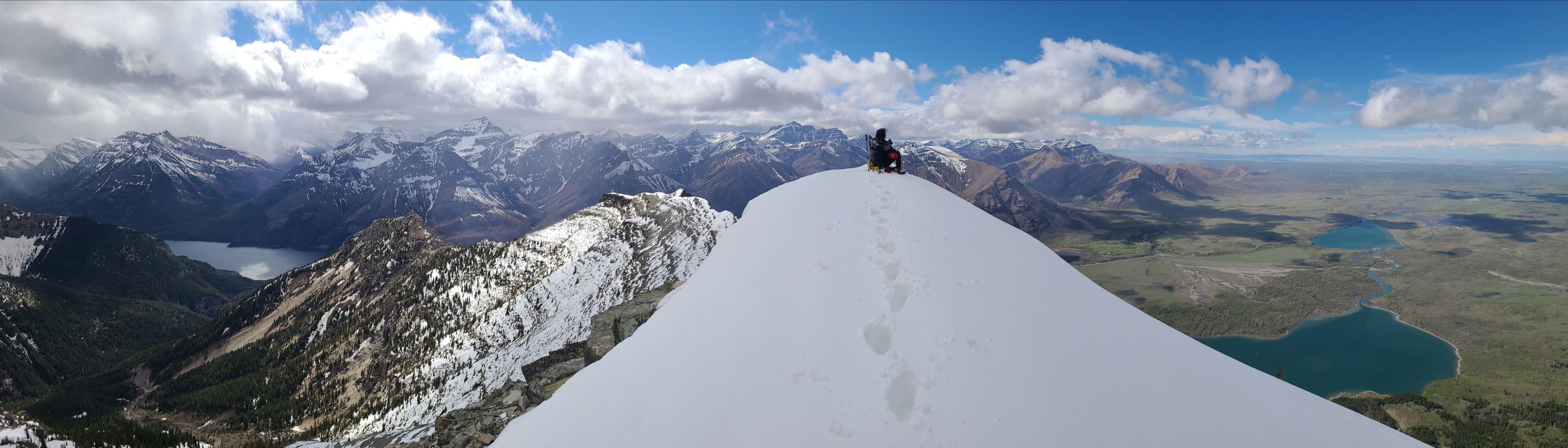
The snow-capped summit of Vimy Peak (2385 m).

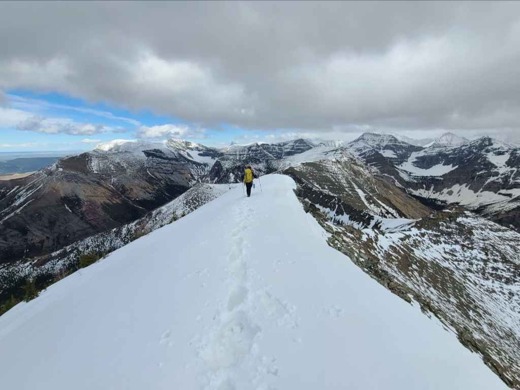
Brad leads the way across some VERY deep snow…

Before settling in to enjoy the view.

I know it’s only May, but this will rank as one of my favourite photos for 2021.
I join Brad on the summit. (Photo by Brad Wolcott)

A pano to the southeast.

The view across Upper Waterton Lake to Campbell Mountain (left), Mount Richards (right of centre), and Mount Alderson (far right).

A closer look at Campbell Mountain inside Glacier National Park.

A better view of Mount Richards (left), Mount Alderson (right of centre), and Bertha Peak (far right).

Bertha Peak is in the centre with Buchanan Ridge and Piinaquiium / Ahkoinimahstakoo (Mount Blakiston) on the right.

Looking northwest at Mount Galwey (left of centre), Mount Dungarvan (centre), “Rogan Peak” (centre), and Bellevue Hill (far right).

Gazing north and onto the prairies. Bellevue Hill and Lakeview Ridge are on the left.

The late afternoon sun highlights Sofa Mountain (centre) while uniquely-shaped, Ninastako, draws attention on the far right.

The view south at Arras Peak (left) and Mount Boswell (right). Mount Cleveland (centre) is entirely obscured from view.

I’ve said it before and I’ll say it again, “Always bet on Brad!” 😁

Apparently I decided to wear pigtails today… 😂
With time at a premium, we begin to head back.

Brad pauses to take in Sofa Mountain (left) and Ninastako (centre).

To avoid deep snow on the upper portion of the trail (centre right), we would return the way we came.

We found that a ‘ladder crawl’ was the easiest way to descend.

The snow allowed for a speedy descent.

It would take just over an hour to make it from the summit to Lion’s Head (centre).

Our sheep friends were still in the same spot.

Us doing our thing and the sheep doing their thing.

Looking back after crossing a snow gully.

It was hard to stop taking photos!

Arriving back on Lion’s Head.

Brad stops for one last look at Lion’s Head. This was a great objective!

Emerging onto the Vimy Peak trail.

A slightly different angle of Lion’s Head. Maybe the thin line of trees down its cliffs are part of the mane? I can definitely see how it looks Simba-esque from this perspective. 😁

The blue sky won’t last long…

As rain is on the way.

The lower section of trail is quite scenic.

Arriving back at the junction with Wishbone trail. From here, it is another 6.5 km to the trailhead.

Happy to be back on even terrain.

Here comes the rain!

Of course, with rain come rainbows… and hopefully leprechauns with Lucky Charms! 😳

Run Brad! Run!

Thankfully, the rain moved to the southeast and we were once again in the sun.

Brrrrrrrr! 😬

The fantastic scenery begs for another pano…
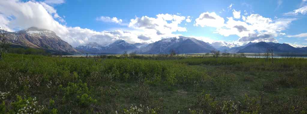
But not just one pano…

Because one would not be enough…

Not even close to being enough! 😁

Evening sunlight on Sofa Mountain.

Arriving back at our vehicles after ~28 km over 9 hours. Once again, Brad suggested a gem for an objective! 😁 Though Lion’s Head was a last minute decision because of the weather, it turned into a superb early season ascent of Vimy Peak. Again and as always, I’m grateful to live in this amazing part of the world. Peace.


Leave a Reply