
⚠️ Hiking and scrambling are inherently dangerous activities. Please read my Disclaimer. ⚠️
After an extremely quick trip up the Chief Mountain Highway Fire Lookout, Andrew and I noted that the weather over the East Peak of Lakeview Ridge looked tolerable, so we decided to make the short drive to the Horseshoe Basin trailhead and try our luck. Though it’s the smallest of the three peaks on Lakeview Ridge, the East Peak presents an intriguing east face that contains numerous opportunities for scrambling – and on a day like today, a measure of reprieve from the wind.
Well, not only did we find shelter along with some great scrambling, but we were greeted at the top by the coolest rainbow that I’ve ever seen on a mountain. Unfortunately, despite our best efforts, we could not locate the pot-of-gold but we did enjoy a leisurely exploration of the east face’s colourful argillite as we descended further to the north of the summit.
In short, this unexpected destination was just the ticket to salvage a day beset by terrible weather. Though this was my second trip to the East Peak, the bonus of a short, but fun scramble made the mountain seem much bigger than it actually is. Having back pocket options like this are a must when hiking in southwest Alberta, because even reliable weather services such as SpotWX, often understate the intensity of the wind. That so many of these small front range peaks have multiple ways to the top, makes repeating them an entirely new experience and more often than not, save me from returning empty-handed.

To get to Lakeview’s East Peak, we drove north from the Waterton Park gate on Highway 6 for ~2 km until we came to the Bison Paddock Road on our left. We then drove ~1.4 km to the trailhead. Note, if the road is closed for the season, you will have to park at the entrance and hike the distance to the trailhead.
From the trailhead we hiked for ~280 m to the junction of the north and south branches of the Horseshoe Basin trail. We then kept to our right to stay on the north branch. Approximately ~800 m from the junction, we came to an unbridged creek crossing and shortly afterwards, another junction where we took the left fork as we began to head towards the East Peak.
After hiking for ~400 m along the trail, we then left it to head directly to the east face of the East Peak – an overland distance of ~1.4 km. From the base of the east face, it was an easy scree slog to reach the cliffs. From here it was a choose-your-own-adventure for scrambling, and after testing out a couple intriguing chimneys, I found a better route further to climber’s right. Andrew meanwhile, chose a more direct line to the summit and emerged on the summit ridge a hundred or so metres closer to the actual summit than I did. From the base to the summit, it was a ~92 m elevation gain.
Once on the summit, we continued north and along the ridge for ~660 m until we found an easy route down. However, shortly after beginning our descent, we became sidetracked by the cool rock, and ended up scrambling and traversing the east face northwards for another ~615 m until we finally decided to call it quits.
From the base, we then hiked ~550 m to rejoin the Horseshoe Basin Trail just to the south of Horseshoe (Burton) Lake. Once back on the trail, it was an easy ~3 km hike back to our vehicles.

Our total roundtrip distance was 9 km with total elevation gains of 776 m. Our total roundtrip time came in at 3 hours and 30 minutes even.

Our starting point at the Horseshoe Basin trailhead with the East Peak of Lakeview on the far right.

The wind was intense, but at least it wasn’t raining! Bellevue Hill is on the left with “Rogan Peak” on the right.

Approximately 280 m from the trailhead, we came to the junction of the north and south branches of the Horseshoe Basin trail. We kept to our right to stay on the north branch.

Easy hiking alongside the Waterton boundary fence.

Descending towards Galwey Brook.

Andrew makes an easy crossing of Galwey Brook.

Shortly after crossing the creek, we came to a fork in the trail. We would keep to the left.

Mount Galwey (left of centre) would be free from the clouds for only a short period of time. Outside of the East Peak, the weather over its neighbouring peaks was downright miserable.

Still on the trail with the East Peak on the right.

Leaving the trail to make a ~1.4 km beeline to the base of the East Peak – where contrails form an X to mark the spot.

Looking back to the Chief Mountain Highway Fire Lookout (centre), where we were earlier in the day.

Navigating our way through sun-bleached trees. (Photo by Andrew Nugara)

Andrew takes the lead as we close in on the base.

Almost there…

Gazing up at some cool options for scrambling.

I’m staggered by a gust as I make my way towards the shelter of the rock. The wind was so intense, that we had to be careful not to tackle any exposure where we’d be at its mercy.

My view back as Andrew starts up from the base.

Looking across to Andrew. We would end up taking separate routes to reach the summit ridge.

Lots of options to choose from!

My first thought was to check out the chimney to the left of centre.

This looked interesting…

However, it was a little steeper and more unforgiving than I anticipated…

I then tried exploring this crag, but it also turned me back.

Finally, I began to trend to climber’s right to see where Andrew has gone.

There he is! He had found a nice line to the summit ridge. 😁

I however, decided to give some serious scrambling one more try… (Photo by Andrew Nugara)

My view from the previous photo.

No turning back now… (Photo by Andrew Nugara)

Almost there…. (Photo by Andrew Nugara)

Arriving safely at the top. (Photo by Andrew Nugara)

My view over to Andrew from the previous photo…

And also my view back down. There were plenty of little ledges to take advantage of.

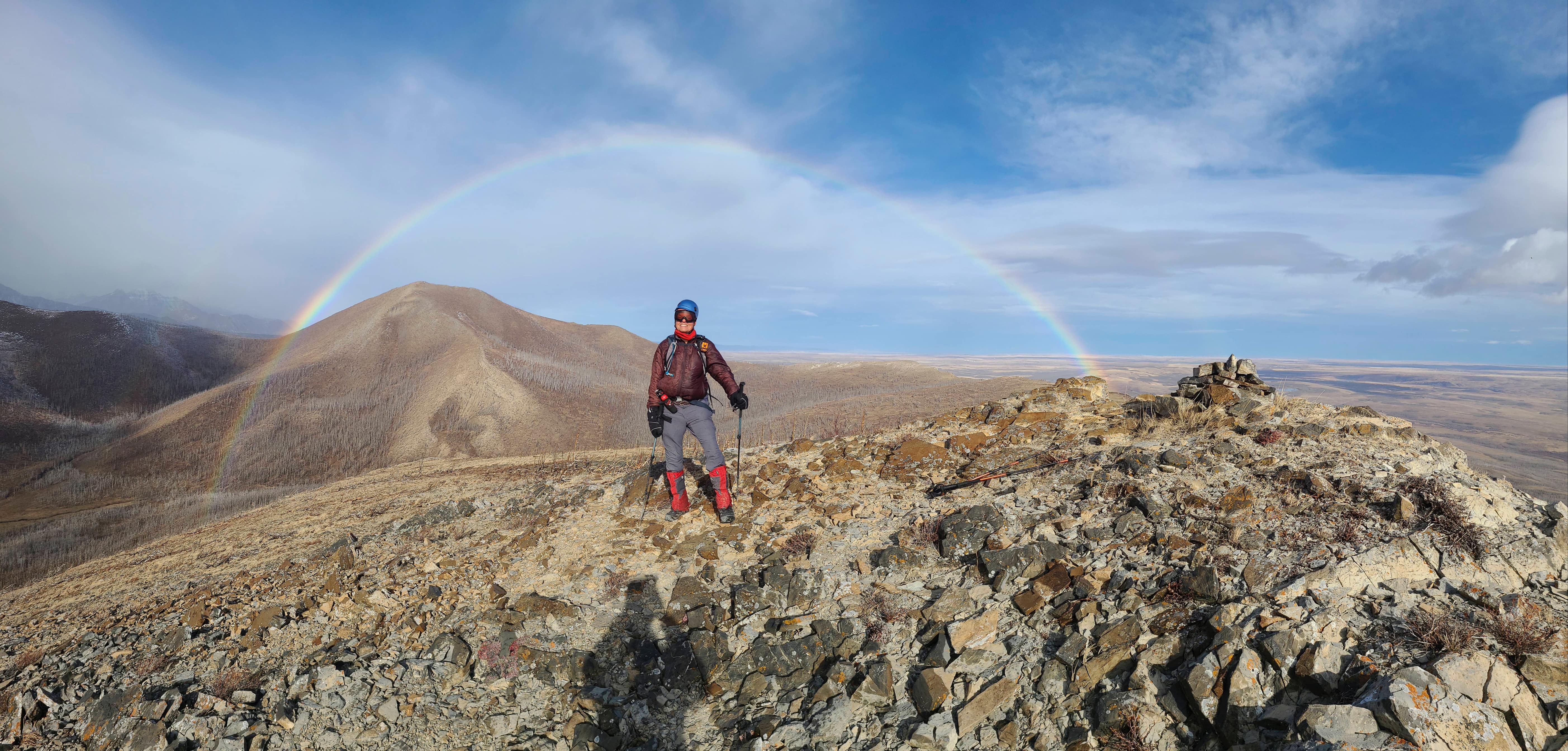
The view that greeted me when I emerged onto the ridge. How cool is this! 😁

Beset by wind, Andrew leads us towards the summit.

The summit of the East Peak (1777 m) of Lakeview Ridge.

A pano to the west highlights the nasty weather.

Rain moves toward us from Bellevue Hill.

The wind made it nearly impossible to take a steady photo. This is my best attempt at a closeup of the summits of Bellevue Hill (left) and Mount Galwey (right).

Gazing across to “Rogan Peak” (left) and Mount Dungarvan (right of centre).

The summit of Lakeview Ridge.

The rainbow made for a cool view of the North Peak of Lakeview.

For anyone who has ever wanted to see a ‘Golden Arches’ at the top of mountain, here you go! 😂 Seriously though, this has to be one of the coolest photos I’ve taken this year.

Andrew leads us a short distance from the summit as we continue to marvel at the rainbow.

My turn under the arch. (Photo by Andrew Nugara)

Now, where is that pot-of-gold? (Photo by Andrew Nugara)

Another great shot of the rainbow by Andrew! (Photo by Andrew Nugara)

I race toward the end of the rainbow to search for gold. 😂 (Photo by Andrew Nugara)

Well, that sucks. The rainbow keeps moving away from us… 😂

Looking back to the summit.

Approximately 660 m from the summit, we found this direct and easy route off the mountain.

However, we soon began to realize that there was plenty of colourful rock to see.

Andrew leads the way as we begin to traverse north and across the east face.

Andrew in his natural argillite environment! 😂

Andrew climbs an interesting formation…

And then enjoys the view from the top.

Coming to another interesting section of argillite.

A quick glance back to the summit, highlights the mountain’s super cool terrain.

It looked like someone used a giant power saw to make this crack. (Photo by Andrew Nugara)

My turn to lead the way. (Photo by Andrew Nugara)

A series of small ledges assist my ascent. (Photo by Andrew Nugara)

Gazing down from the top. (Photo by Andrew Nugara)

My view from the previous photo as Andrew follows me up…

And up.

Wow! Yet again, we come to another gorgeous section of red argillite. (Photo by Andrew Nugara)

This was super cool terrain! (Photo by Andrew Nugara)

As I was sheltered from the wind, I decided to check for a route across the cliff face. (Photo by Andrew Nugara)

I’m not going to lie, there was a bit of a Triple Divide feel to this… 😂 (Photo by Andrew Nugara)

One more look at this cool section of cliff. I made it to the end, and though it looked possible to keep going, the danger from wind gusts prevented us from continuing. (Photo by Andrew Nugara)

My view back to Andrew (centre) from the previous photo.

Fascinating ripple-marked argillite.

Descending alongside the cliff.

Andrew down-climbs a short step.

Looking back to the top. This ended up being such a fun trip! 😂 (Photo by Andrew Nugara)

Nearing the base of the mountain.

Looking back at the large cliff we were just on. The ledge near the top is where I turned around due to wind. The summit of the East Peak is on the far left.

From the base, we decided to head directly towards the Horseshoe Basin trail near to where it passes Horseshoe (Burton) Lake (centre).

A telephoto of Horseshoe (Burton) Lake.

The obligatory old tree photo.

It was an easy ~550 m trip from the mountain to the trail.

Almost at the trail…

Back on the trail and settling in for the ~3 km hike back to the trailhead.

Passing by the East Peak. Don’t overlook this little guy if you are stuck for a backup plan. 😁

The entirety of the east face.

The weather was still miserable over Vimy Peak (centre).

Big sky views from along the trail.

Continuing our easy trip back.

Descending to Galwey Brook.

Depending on the time of year, Galwey Brook may or may not be easy to cross.

Another look over to the day’s previous destination, the Chief Mountain Highway Fire Lookout (centre). Behind it, Ninastako rises through the clouds.

Arriving back at the junction…

Before making the quick hike to the trailhead.

Arriving at the trailhead after 9 km over 3 hours and 30 minutes. Though this was not the trip we had planned for, it was nonetheless an excellent outing that saved the day. Despite this being my second trip to the East Peak, the route to the top made it an entirely new experience, and I could see myself revisiting this peak to try an entirely different route. Finally, a huge thanks to Andrew for yet another fantastic day in the mountains! 😁

A final look at the East Peak from the trailhead. Happy trails everyone! 😁


Leave a Reply