
⚠️ Hiking and scrambling are inherently dangerous activities. Please read my Disclaimer. ⚠️
EDIT: I returned on 23 August 2020 and completed an ascent using the southwest ridge.
Yup. We failed. The long and the short of it is that we simply ran out of time. End of story. Well almost…
I knew we were in for a long day because I’d made the 7.5 km (one way) trip up North York Creek twice before – once for Mount McLaren and then again for Mount Coulthard. After Coulthard, I vowed that when I returned for Andy Good, I would bring a bike. Now don’t get me wrong, hiking the ATV super highway to the base of Andy Good and Coulthard to see the wreckage of an RCAF Dakota DC3 is a worthwhile endeavour. Everyone who likes to hike in southern Alberta should do it once. However, by the third go round, you really just want to get to and from the base of the mountain as quickly as possible.
So off we went, a little later in the morning than what was ideal, but pedal power would hopefully make up for that. The bikes definitely made a difference in certain sections of the trail, but since the elevation gain to the base of Andy Good was about 460m, we ended up pushing the bikes more than we actually rode them. To complicate things, the temperature had already reached 28 c by the time we reached the base, and both Graham and I were sweating buckets.
My original plan had been to ascend to the col between Andy Good and Mount Parrish and then use the north ridge to reach the summit. However, in a fortuitous encounter, we met two hikers along the trail who were returning after spending a couple of days ascending Coulthard and Andy Good. Now in other places, seeing fellow hikers isn’t a big deal, but in the Pass and the Castle Crown where foot traffic is fairly light, coming across other bipeds is always worthy of a trailside conversation. Wendy and Marta (and Wendy’s dog, Ruthie) were super friendly and helpful. They told us that they had tried summiting Andy Good via the north ridge, but were turned back due to the slabs mentioned in Nugara’s book. This came as news to me because I only own the first version of, More Scrambles in the Canadian Rockies, and did not know that Andy Good and McLaren had been added to his latest edition. In a wonderful gesture, they gave us a copy of Nugara’s trip report. Thanks ladies!
The only thing that really bothered me about Nugara’s report was his caution that a return trip along the north ridge might be difficult, particularly the section near the summit. Coming down is always twice as hard as going up, so I contemplated this as Graham and I continued up the trail. After considering a summit approach via the ridge from Coulthard (Nugara’s descent route), we decided to see for ourselves what the north route looked like. After rehydrating and eating some lunch at the plane crash (which Graham had never seen before), we began the steep slog up to the col.
Looking back, I think we should have tackled the scrambling head on, but we diverted too far down to the right and missed the first section of slabs that we had to cross before ascending back up to the ridge. This was a costly mistake because we tackled these on the way back without issue. Had we done this, we would have been able to eventually make our way up to the ridge as per Nugara’s description and save ourselves some time and energy. The heat had played a number on us during the hike up to the col and if you can believe it, we were in the Crowsnest Pass and were praying for a breeze of any kind!
Once we had lost elevation, the direct line back to the ridge over scree did not seem appealing but we should have just done it anyway. Instead, we descended even further and hopped on a goat trail that headed over to the west ridge, gradually regaining the ~100m of elevation that we had lost from the col. The trip to the west ridge was time consuming and by the time that we made it up to a section of solid rock that led to the north ridge, it was already getting late in the day. With ~240 m of vertical elevation left to go and some rain coming in from the west, I pulled the plug because I was afraid that the return trip would be too time consuming and would put us well into the evening hours – even with the bikes. We backtracked towards the col along a higher goat trail and came to the section of slabs that we had previously avoided and crossed these without issue. We returned to the col and descended down the steep slopes to the trail where we had stashed our bikes. The return trip was considerably quick with the bikes, but we still didn’t make it back to Lethbridge until close to 10 pm.
So, we failed. Yet it was still a fun trip coupled with great company, and the west side of Andy Good offers up some amazing scenery. However, I’m now faced with a fourth trip back up North York Creek to get the job done…

Third times a charm right? Well not exactly. Our route description is the same as my Mount Coulthard and Mount McLaren posts, so I won’t repeat it here.

After stashing our bikes in the trees, we made a quick detour over to the plane crash for Graham to have a look and to eat some lunch. The slog up from the trail to the col between Andy Good and Mount Parrish is broken into two very steep sections, with the only reprieve being a small bowl that still contained some snow. In total, it is about 1.3 km from the trail to col with an elevation gain of 451 m. Personally, I thought the section between the bowl and the col was steeper than the section from the trail to the bowl. Regardless, in 28c heat with nary a breeze, it was a bit of an endurance test.

This is the west side of Andy Good. We made the initial mistake of losing too much elevation and then confounded matters further by trying to avoid regaining the lost elevation up the scree slope to the ridge. Instead we lost even more elevation by dropping down to a goat trail and traversing to the west ridge where we began to ascend. Deviating from my initial route and making this second mistake cost us precious time. Even though our route would have led us to the ridge before the summit, it was too late in the day to chance it. As it was, we made it back to Lethbridge close to 10 pm. Summiting would have put us much later than that. On our traverse back, we followed a different goat trail that allowed for minimal elevation loss and which took us directly to the slabs that we tried to initially avoid. We had no difficulty in navigating these slabs, which was a big kick in the pants.
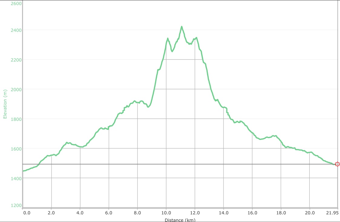
This failed trip ended up being 21.95 km in total distance with 1340 m in total elevation gains. Our total time was 9 hours and 13 minutes.

If you find a wallet at the plane crash site, give this person a call. He gives specific details as to where he thinks his wallet is.
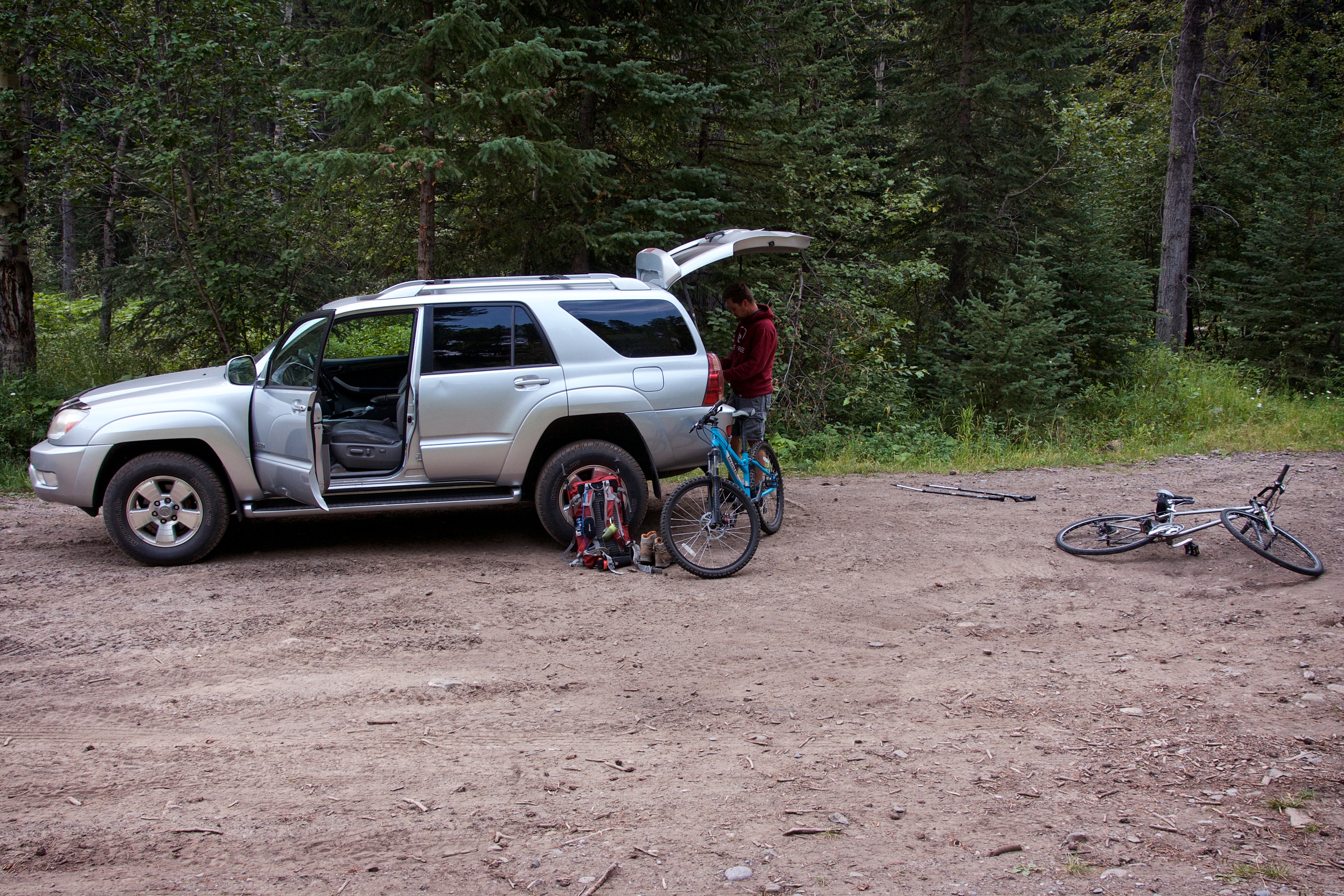
Gearing up at the yellow bridge over North York Creek.

Graham’s partially collapsed hiking poles give the appearance that he is carrying a spear into the backcountry. I’ve tried really hard not to include any extraneous comments about ‘Graham’s spear’ in this post but I can’t guarantee complete success.

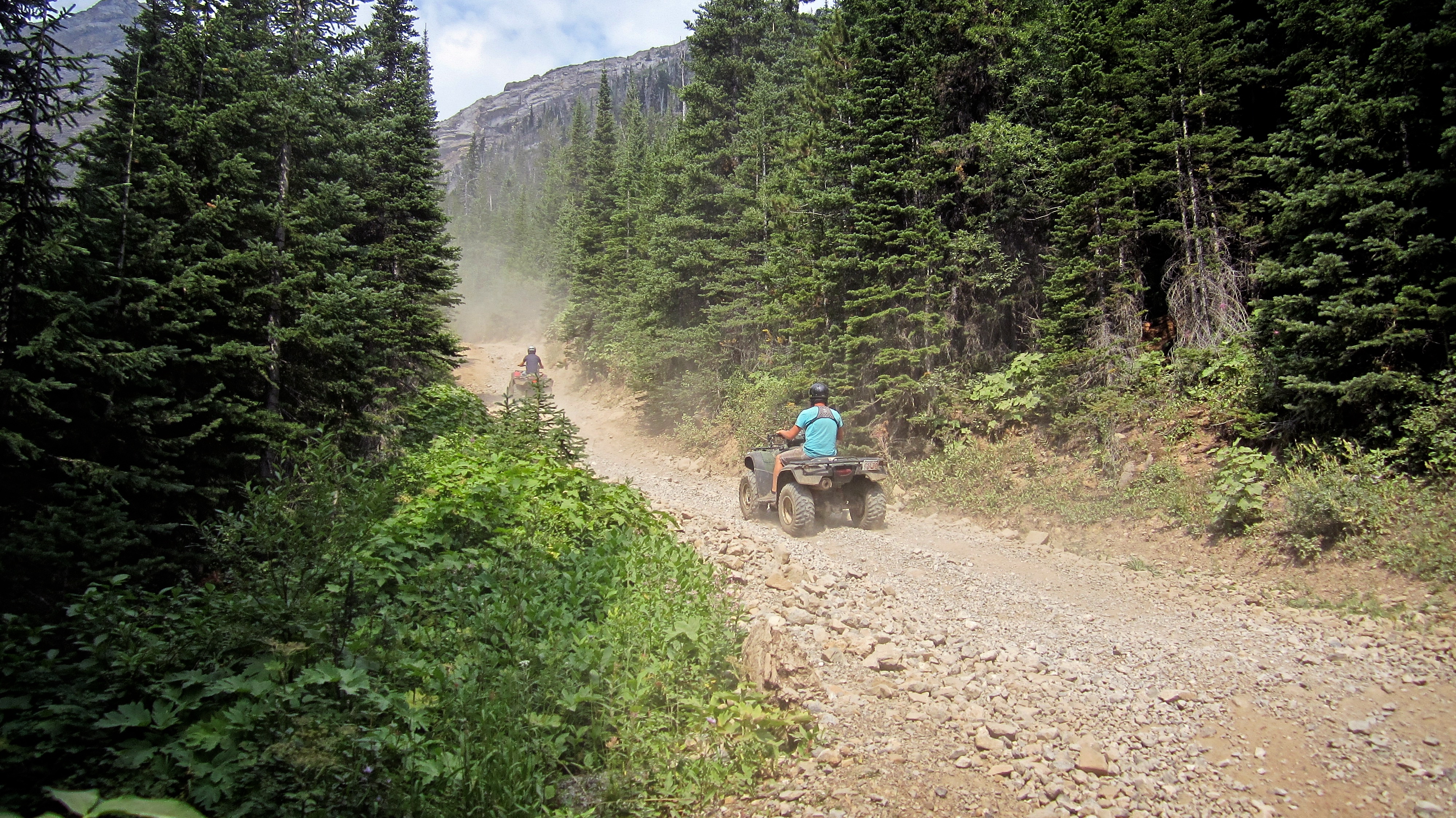
On the way up there were sections where we could ride, however, this was more indicative of the experience.

Comrades on the trail. From left to right: Ruthie, Wendy, and Marta. Wendy and Marta were returning from a few days of camping at the plane crash while they climbed Coulthard and attempted Andy Good. Their firsthand information was invaluable!

Graham crosses a bridge over the creek. Don’t worry, we wore helmets on the way down. Besides, look at Graham’s Rambo headband!

It was hot, and dry, and dusty, and did I mention hot?
Would I be a bad person if I hitched a ride up for my fourth trip?

Andy Good on the left and Mount Parrish on the right. Our route when straight up the slope in the middle.

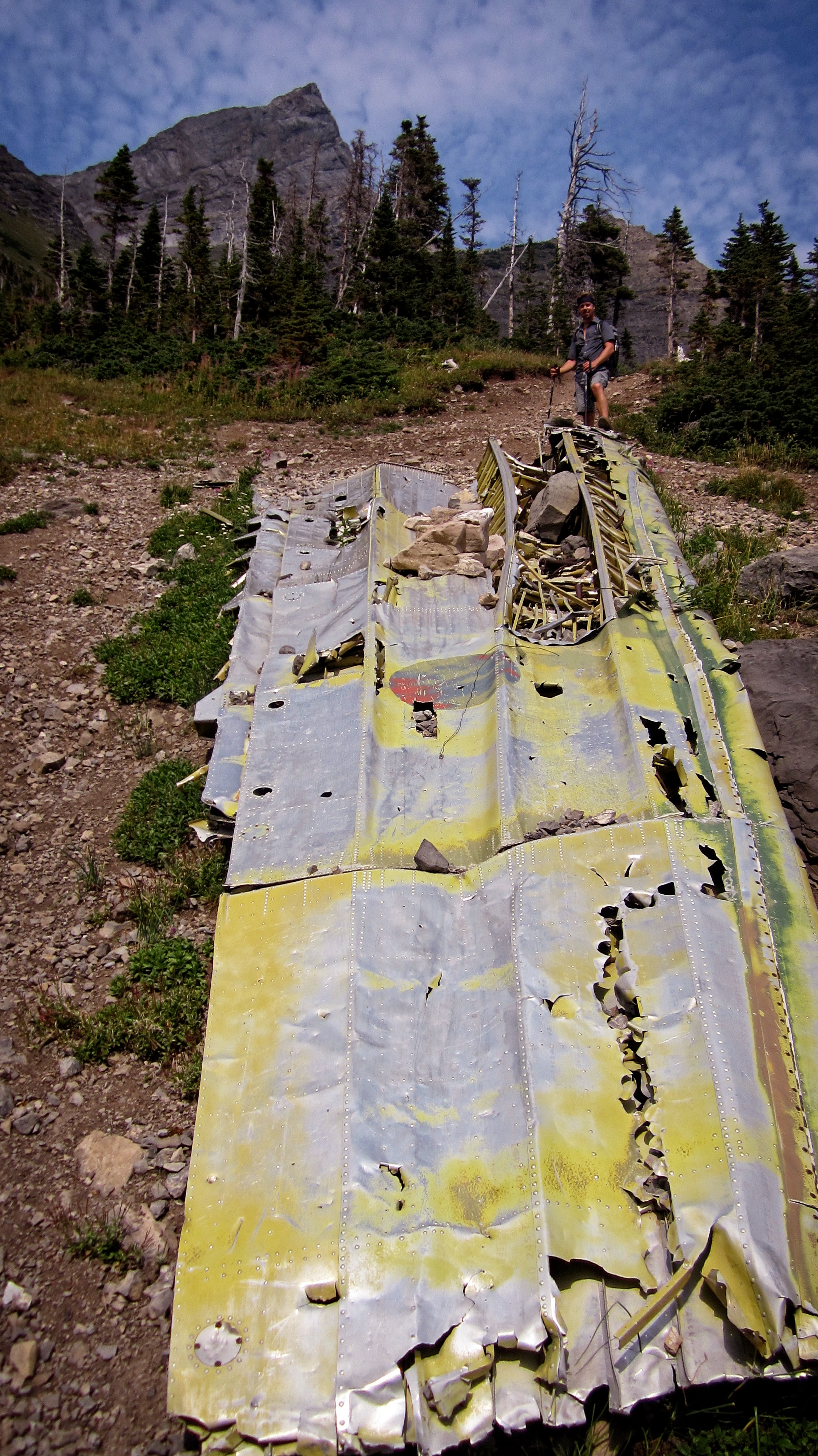
Graham had never visited the plane crash before, so to accommodate his curiosity, we made a short detour. In the winter of 1946, an RCAF Dakota DC-3 that was travelling from Comox, BC to Greenwood, NS, crashed after hitting a nearby peak. All 7 crew members were killed. The sign says it hit Mount Ptolemy, but it seems more logical that it hit Parrish or Andy Good given its final location.

The family of one of the crew members have attached a small plaque beneath the sign. This glimpse into a life cut short is a poignant reminder that this is a place of sorrow.

Graham inspects the tail section of the Dakota DC-3.
A wing sits next to the creek bed.

Wreckage is strewn along the creek bed.

A pretty little waterfall next to the crash site.

Already tired from the heat and the weight of his spear, Graham enjoys lunch before starting up the mountain.

Looking down at the trail as we near the top of the first slope.
The view towards the col from the crest of the first slope. The second slope that leads to the col is much steeper than it looks.

Looking back at our approach route along the North York Creek trail. Mount McLaren is on the left and Mount Coulthard is partially visible on the right. Bluff Mountain, Willoughby Ridge, and Turtle Mountain are visible in the distance.

The small bowl located between the first and second slopes was a brief, but welcome break. I seriously considered laying down on the snow just to cool off.

Graham trudges up the slope towards the col while a herd of goats mock us from the pinnacles.

The last section before the col.

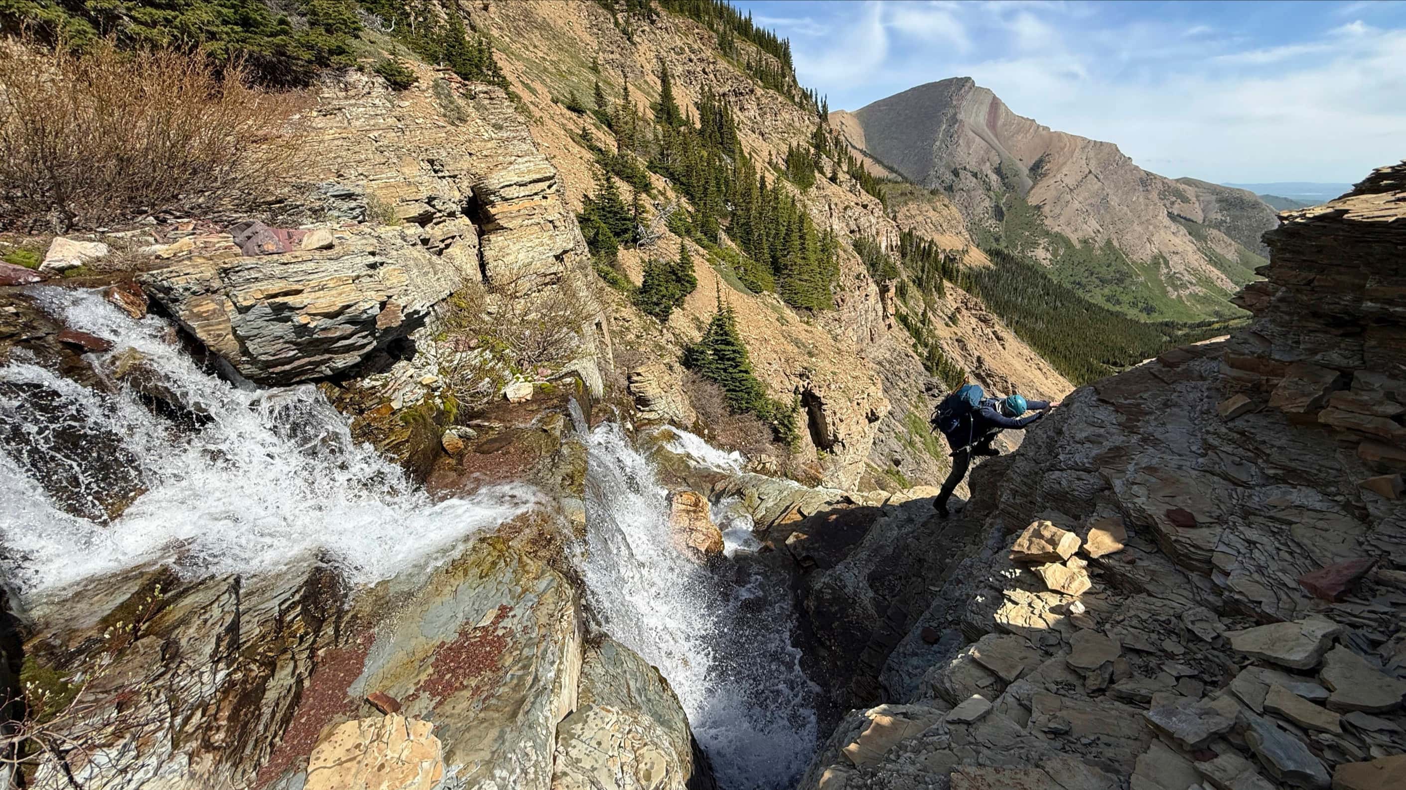
Standing on the col and looking directly at the section we chose not to scramble. We avoided this by descending to the right where we unfortunately went too far. Next time I think I will try this head on.

The view to the SW from the col. Mount Ptolemy is the tall peak on the distant left and Peak 3 (“Pharaoh’s Peak) of the Northwest Ridge of Ptolemy is in the centre.

Mount Parrish looks really impressive from the south.

Looking towards the summit (not pictured) of Andy Good from just below the col.
This picture makes me sad because it clearly shows my mistake. We should have just gone over the slabs and then up the scree to the ridge – just as Nugara instructs. We were tired from the heat and tried to choose an easier way than simply pounding the scree.

If you’re going to choose poorly while route finding, you may as well smile and enjoy the adventure. Mount Parrish is behind me.

Looking back at the col from a cairn that we found near the base of the west ridge.

Heading up the west ridge with the hope of gaining the ridge. Contrary to what the Rolling Stones might say, time was not on our side.
Gathering clouds provided the right ambience for some stellar views of Mount Parrish.

Same picture as above but a few minutes later. I couldn’t decide which one I liked better.

Starting up a section of rock towards the ridge.
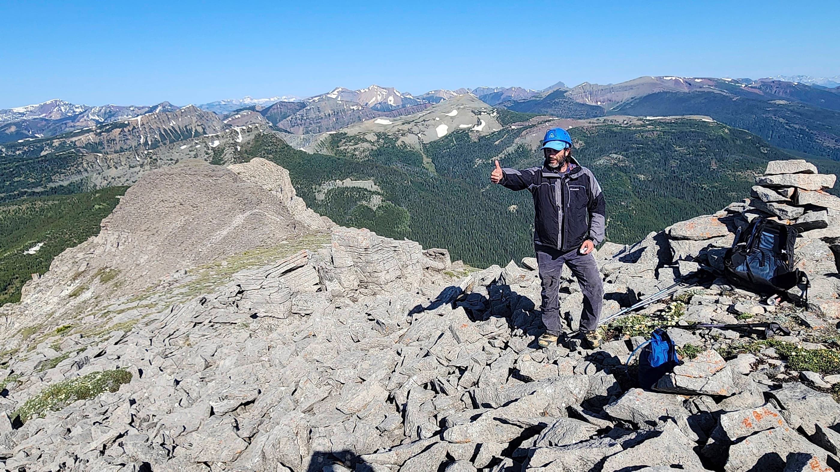
Graham at the highest point we reached (2421 m) moments before I pulled the plug due to time. Going up this rock ramp wasn’t an issue, but we had run out of time and when coupled with what looked like some rain on the way, it was time to go. The summit of Andy Good sits at 2662 m, so vertical elevation wise, we weren’t too far off.

A dejected Graham after I made the executive decision to turn back. Poor guy!

The view west from the highest point that we reached. Peaks 1 (“Mummy Mountain”), 2 (“Anubis Peak”), and 3 (“Pharaoh’s Peak”) of the Northwest Ridge of Ptolemy (NROP) are in the centre. NROP is a very fun traverse!

Graham crosses some slabby sections that we should have tackled at the beginning.

The beginning of the north ridge of Andy Good Peak from the col.

Heading down from the col. On the way back we utilized some goat trails beneath Mount Parrish that made the descent less steep. I will use these to ascend when I come back.

On our way down the slope to the trail, a dirt biker made an impressive climb up the slope and then an equally impressive descent. I chatted with him at the bottom and he told me that he was a professional rider.

I received a Life Straw for Christmas and this was as good a time as any to test it out.

Graham is glad that we didn’t have to hike all the way back.

We may have had to walk the bikes most of the way up, but they sure paid for themselves on the way back.

Hiker’s tan 😉 Even though we didn’t make the summit, it was still a fun adventure with a great friend. I guess I should start getting ready for my fourth trip up the North York Creek trail… Edit July 2017: In hindsight, when I go back to attempt Andy Good again, I will use the same approach used on our ascent of Chinook Peak.

Leave a Reply