

⚠️ Hiking and scrambling are inherently dangerous activities. Please read my Disclaimer. ⚠️
Saying goodbye to the group after summiting Maverick Hill, I set off by myself towards Poker Peak which is located ~2.7km to the north. This was my second trip to Poker Peak. In April 2014, Jeff and I enjoyed a snowshoe ascent which utilized a route that followed the Adanac Ridge (Canada spelled backwards) from north to south. This time, I would complete my traverse of the ridge by approaching from the south.
Poker Peak is probably the area’s easiest summit to ascend and it would not be stretching things to suggest that someone who is physically fit could reach it from the Adanac Road in 30 minutes or less. Since I was coming from Maverick Hill, I had previously stashed my bike in the trees beneath Poker Peak with the intent of riding over to nearby Clubs Peak and Spades Peak. After summiting these prominent points on Hastings Ridge, I would then coast down the Adanac Road to my vehicle.
However, about a kilometre after starting up the road towards Clubs Peak, I encountered a ~400m section of knee deep snow that I couldn’t easily circumvent. While I was contemplating post-holing my way up the road, I heard something large crashing through the trees a short distance up the road to my left. I yelled several times as the crashing grew closer, until whatever it was, finally got scent/sight/sound of me and turned to head down the slope to the valley. After pausing for several minutes (and being glad to be in radio communication with Brad and Raquel who were having lunch at the Maverick Hill trailhead), I decided to try and leave the road to climb an outlying slope on Hastings Ridge as a shortcut to Clubs Peak. Leaving my bike on the side of the road, I started to ascend a small gully but was forced to turn back when I found myself in knee to waist deep snow. I returned to my bike and enjoyed a super quick ride back to my 4Runner. After chatting with Brad and Raquel, we decided to drive the short distance to Cherry Hill and hike to its summit. However, I’ll return in a couple of weeks and try my hand at Clubs and Spades again.
Edit 1 November 2016: I finally returned to complete Clubs Peak and Spades Peak and my life has now been fulfilled.

Maverick Hill, Poker Peak, Clubs Peak, and Spades Peak are readily accessed from the Adanac Road. Not knowing if the road would be free of snow from the Hillcrest side, we decided to approach it from the east using Township Road 64A. From Lethbridge we drove west on Highway 3 until we came to Highway 507. Here we turned left and headed south towards Beaver Mines for ~8.8km until we came to Township Road 64A, where we turned right. We followed this scenic, gravel road for ~14.1km until we came to the Adanac Road junction. This is where we turned right onto the Adanac Road and followed it north for ~2.8km until we came to the Maverick Hill trailhead. From the summit of Maverick Hill, I enjoyed an enjoyable hike north along the Adanac Ridge for ~2.7km to the summit of Poker Peak.
It took us only 44 minutes to hike the ~1.4km to summit of Maverick Hill. My solo trip along the ridge to Poker Peak (1935m) was ~2.7km in length and took me 1 hour and 6 minutes. Including my brief excursion to try and reach Clubs Peak, my combined time was 2 hours and 52 minutes with a distance was 8.7km. If I include my third summit of the day, Cherry Hill (not shown on the graph), my total hiking distance for the day was 14.3km with total elevation gains of 1052m, and a total time of 5 hours and 23 minutes.

After summiting Maverick Hill, I said goodbye to Charlie, Brad, Raquel, and Maria and began my ridge walk north to Poker Peak. Since Poker Peak (1935m) is higher than Maverick Hill (1875m), the hike gains elevation over easy terrain.

Looking down at our vehicles from the ridge below Maverick Hill.

A small cairn marks the route to Poker Peak.

To avoid snow, I had to leave the trail when I came to a dip in the ridge and skirt briefly to the west.

Looking back at Maverick Hill from partway down the ridge.

Ginger Hill is in the foreground. Ginger could be a tricky one to get access to as only the north end is inside the Castle area. The summit is on a leased public land and the land immediately to the west and east is private. In the background is Blue Mountain.

Someone had enjoyed a campfire and sardines. Not my snack of choice when I have a campfire, but each to his own I guess.

The trail was easy to follow.

The summit of Poker Peak came into view after about 45 minutes of hiking.
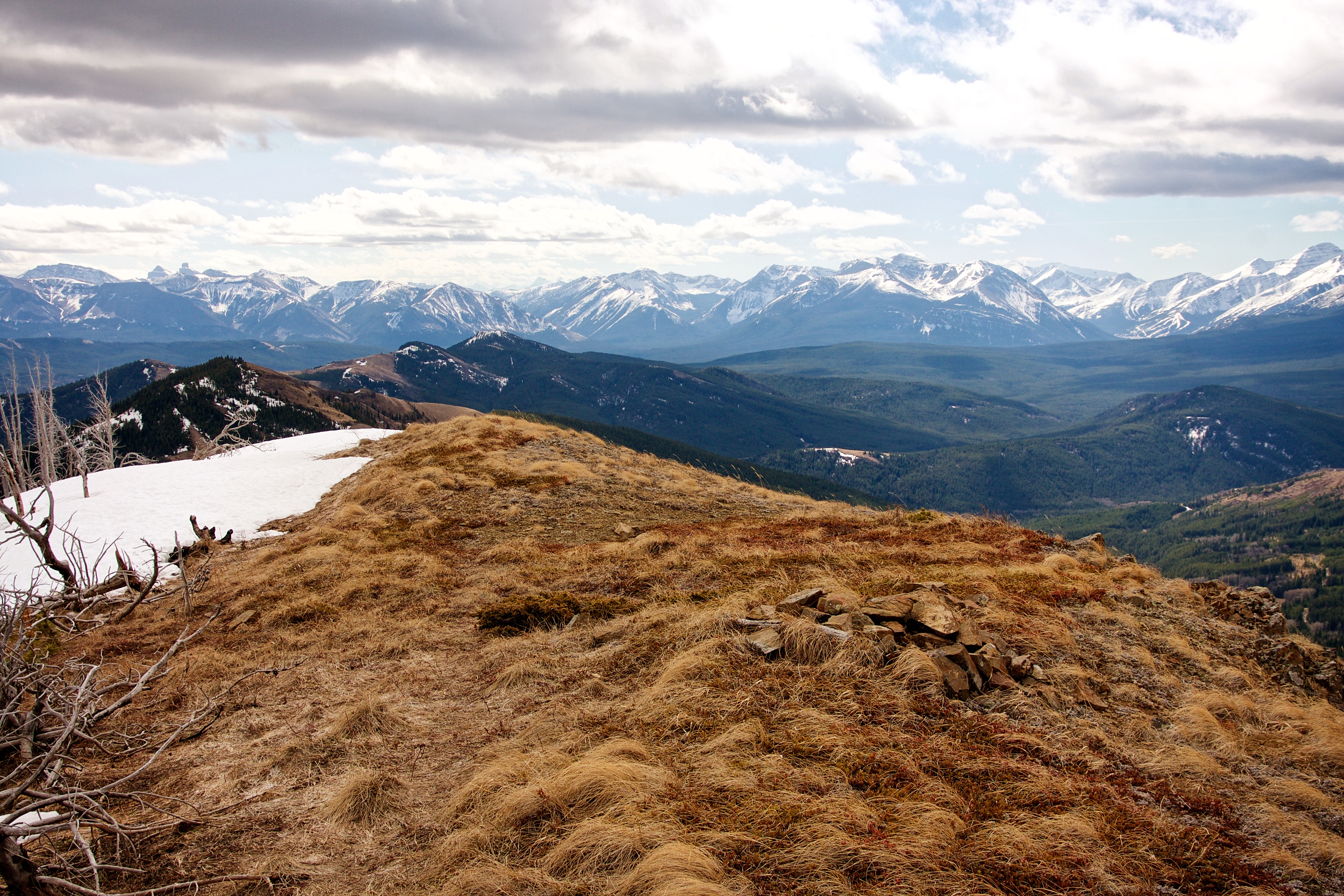
The summit of Poker Peak (1935m). This was my second time here.
Looking west from the summit at Hastings Ridge. Clubs Peak is on the left and Spades Peak (the highest point of Hastings Ridge) is just poking up to the right of centre.

A pano to the south.

A pano to the northeast.

Looking west at the Flathead Range. Clubs Peak is in the foreground on the right. The area around Clubs was once the site of the Adanac #3 open pit mine.
Looking west at Mount Coulthard in the distant centre. The summit of Spades Peak is just to the right.

Looking north at Hillcrest Mountain, Turtle Mountain, and Bluff Mountain. The summit of Hearts Peak is on the far left.

Looking north at Robertson Peak and Tallon Peak. The South Peak of the Livingstone is poking out from just behind the tree.
Looking south from the summit. In the foreground is Maverick Hill and Carbondale Hill. In the distance from left to right: Mount Gladstone, Table Mountain, ‘Table Top’, ‘EaglePeak’, Whistler Mountain, the Whistler Fire Lookout, Lys Ridge, Southfork Mountain, and Mount Haig. The distinctive shapes of Windsor Mountain and Castle Peak can also bee seen in the distance on the left.

Descending from the summit to the Adanac Road.

Sun bleached trees from the 2003 Lost Creek Fire.

The trail is well used.

I arrived to find that my bike was still where I had left it. Shortly before this, I found a set of cougar tracks so I’m glad that I locked my bike to prevent some crazy cat from taking it on a joy ride. You just can’t trust wildlife these days… 😉

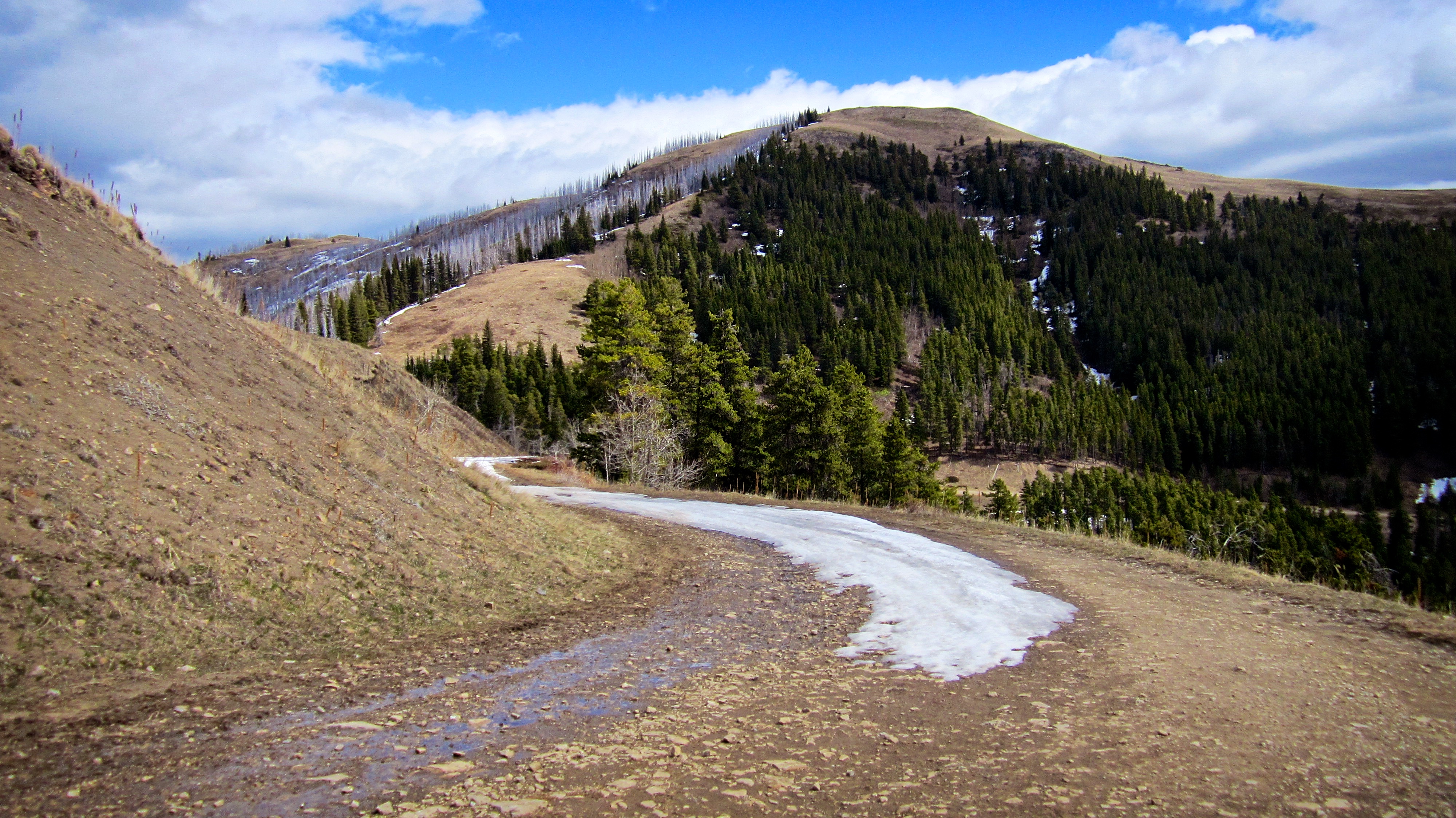
The snow covered road to Clubs Peak from the base of Poker Peak.

For the first kilometre or so, travel up the road was easy.
Looking back at Poker Peak.

Here is where I encountered ~400m of soft snow with little room on either side to pass without post-holing. It was also here that I heard a large animal moving towards me through the trees on the left. After yelling for several minutes, whatever it was, began to slowly move away from me towards the valley.

After further contemplation, I decided to leave the road and try a shortcut to Clubs Peak over a lower section of Hastings Ridge.

However, I was not interested in post-holing through knee deep snow. If I wanted to do that, I would have stayed on the road.

So I decided to abort my Clubs and Spades attempt to enjoy a rather speedy ride back to my 4runner. I will return in a couple of weeks to reattempt both peaks. Fortunately, Brad would join me for a consolation ascent of nearby Cherry Hill, which would be my third summit of the day. Click here to read my Cherry Hill trip report.
Click here to read about my return trip to Clubs Peak and Spades Peak.


Leave a Reply