
⚠️ Hiking and scrambling are inherently dangerous activities. Please read my Disclaimer. ⚠️
Less than a week after tagging, Mount Dungarvan, Andrew and I were back in the neighbourhood to try something incredibly rare: a loop route in Waterton that Andrew has never done. 😲 Though he had previously ascended “Dundy Peak” in 2016, and had twice (2006 & 2020) ascended, Cloudy Ridge, he had never combined the two into one trip. This made me happy, because when it comes to Waterton, I always feel bad that I’m the newbie who’s constantly asking him to repeat trips. Graciously, he’s always game, but it’s nice to finally find some new terrain that he can explore. 😊
Indeed, today’s loop strung together Andrew’s ascent route of “Dundy” (a combination of Dungarvan and Cloudy) as outlined in, More Scrambles in the Canadian Rockies 3rd edition, with his ascent / descent route of Cloudy Ridge, that’s also in, More Scrambles. The new part for Andrew (and of course me) was the section of ridge between the two peaks. His friend Liz and her husband had navigated the ridge back in June and their account had intrigued Andrew to try it, even though they used the Cloudy Ridge route for both ascent and descent.
Thus, with the anticipation of another enjoyable approach via Lost Horse Creek, followed by what promised to be a gorgeous egress along Red Rock Creek, we rendezvoused early this morning in the Red Rock parking lot, where we left my car and drove Andrew’s back to the Lost Horse parking area. Weirdly, this was the first time we’d shared a vehicle since the pandemic began.
Our scramble up “Dundy” was highly enjoyable with the crux being a short, but tricky climb over the limestone band guarding the false summit – the same band that we had to negotiate on Dungarvan. From the summit, we then made our way towards Cloudy Ridge, a walking distance of ~3 km that included sections of moderate scrambling. Our eventual descent along Cloudy’s south ridge was benign compared to our route up “Dundy”, with our day culminating in a fun trip through Red Rock Canyon, after which, we then drove my car back to our starting point at Lost Horse Creek.
I’ve been fortunate to have had several great trips already this year, but this has to be one of my favourites. Not only was good scrambling combined with a fun ridge walk; the routes for ascent and descent were the ideal mix: with the biggest challenge being encountered on the way up and a more relaxed posture reserved for the way down. The end trip through Red Rock Canyon under a bright afternoon sun, was stellar as always.
All in all, this was an absolutely fantastic day in the mountains! If you are confident in your scrambling abilities, then this is a really fun route to try – and if you have awesome company like I did, then you definitely can’t go wrong! 😊
Be sure to read Andrew’s awesome trip report!

Our ascent and descent routes are clearly outlined in Andrew’s, More Scrambles in the Canadian Rockies. To get to “Dundy Peak” and Cloudy Ridge we turned onto the Red Rock Parkway and drove to the Red Rock Canyon parking lot. Here, we left one vehicle before driving the other vehicle ~2.3 km back along the Parkway to the Lost Creek parking lot. This extremely small area was the starting point.
From the Lost Horse parking lot, we followed alongside and inside Lost Creek for ~1.9 km until we came to the start of “Dundy’s” southeast ridge – immediately after crossing the first tributary into Lost Creek. Depending on the time of year, the water in Lost Creek may make travel difficult, and if that was the case, we would’ve had to spend the majority of our time, high on the left bank. Regardless, I’m glad that I’d brought a set of approach shoes that could handle both the water and the slippery rocks.
The first ~2.3 km along the southeast ridge was a straightforward hike that gained approximately 512 m in elevation. The scrambling began on the shoulder and continued all the way to the summit. Most of the scrambling before the limestone band, could have been negated by trending climber’s left whenever we were faced with an obstacle.
The limestone band itself was formidable, and there did not appear to be an easy weakness anywhere on the south face of the mountain. We identified three routes to climber’s left of the ridge: the first being a possibility; the second being the one we used; and a third that looked to be a hundred or so metres away, but which we didn’t explore. The second weakness can be identified by noting a pointy rock formation near the top. This crux is not huge (perhaps 3.5 m in height), but the tricky part is encountered about halfway up, where we found ourselves perched precariously as we crossed from one side to the other, before scrambling up and onto more favourable terrain.
Once above the limestone, the trip to the false summit required only easy scrambling, and from the top, the true summit was still ~630 m away via an enjoyable ridge walk that featured more easy scrambling.
Getting to Cloudy Ridge from the summit of “Dundy” was an enjoyable ~3 km ridge walk (~111 m elevation gain) that featured a moderate down-climb as we left “Dundy”, followed by moderate scrambling to reach the false summit and then the true summit. The key to reaching the summit of Cloudy, was to circle the summit block to climber’s right until we found ourselves on the north side of the mountain. From here, we could then scramble the short distance to the top.
To descend, we returned to the false summit and followed the south ridge for ~3.4 km (911 m elevation loss) down to Red Rock Creek. The only obstacle we encountered, was the same limestone band that proved to be the crux on “Dundy”; however, the weakness was more pronounced and down-climbing it was not difficult. The bottom of the south ridge presented us with the option to drop into Red Rock Creek on our left or on our right. We aimed left at first, before dropping to the creek on our right, because the creek on the left features a large waterfall that would’ve forced us to backtrack.
We then followed Red Rock Creek for ~3.2 km until we arrived at the parking lot. From here, we drove back to our starting point at Lost Horse Creek.

Our total roundtrip distance was 17.9 km with total elevation gains of 1296 m. Our total roundtrip time was 9 hours and 6 minutes. For reference it took us 4 hours to cover the ~7.2 km hiking distance (983 m elevation gain) between our car and the summit of “Dundy”. It then took us another hour and 20 minutes to reach the summit of Cloudy Ridge.

Starting our approach along Lost Horse Creek.

Make sure to bring approach shoes that can handle both water and slippery rocks, as you will be inside and beside the creek for ~1.5 km.

As I mentioned in my Dungarvan report, Lost Horse is really scenic but you can’t appreciate it until the sun is shining. Fortunately, with this loop, you get to experience an even prettier, Red Rock Canyon, at the end of the day. 😊

Despite being 6:30 am, there’s still plenty of colour to see. (Photo by Andrew Nugara)

Even though he’s been here many times before, Andrew still stops to take it all in.

Scrambling up and around a waist-deep pool.

Great scenery inside of a small canyon.

Loving every minute of our approach! Now, to be fair, if it weren’t in the middle of a hot summer… maybe not so much. 😊 (Photo by Andrew Nugara)

Avoiding another deep pool.

Approximately 1.5 km from the parking lot, we emerge onto easier terrain.

A sticky geranium.

Arriving at the first tributary into Lost Horse Creek, approximately 1.9 km from the parking lot. The southeast ridge of “Dundy” starts immediately on the other side.

Time to pack away our approach shoes.

Showy fleabane.

Starting up the ridge with the false summit of “Dundy” on the left.

Gleaning a better view of the ridge’s upper slopes.

These new saplings are a great sight to see! Perhaps my grandkids will enjoy this as a forested hike when they are adults. 😊

Morning sunlight on Mount Blakiston.

The view back after gaining some elevation. Note how the ridge curves before reaching Lost Horse Creek. The first tributary into Lost Horse is on the right and the second tributary – which we followed off of Dungarvan – is on the left.

Emerging onto the upper slopes of the ridge. The summit of “Dundy” is barely visible to the right of Andrew; though we won’t see it again until we’re on top of the false summit.

‘Hair’ the bells ringing? 😉

On the shoulder with the false summit dead ahead. The summit of Dungarvan is on the right.

Arriving onto some interesting terrain.

Andrew tackles a small step…

Followed closely by me. (Photo by Andrew Nugara)

Most of the scrambling prior to the limestone band (top centre) can be navigated by trending climber’s left when faced with an obstacle.

Andrew’s view back to me. The ridge on the right may look like a tempting alternate from Lost Horse; however, it becomes serious business where it joins the mountain and is not something that I’d want to try. (Photo by Andrew Nugara)

Bypassing the first obstacle to climber’s left.

The striped rock reminded me of tiger-flavoured ice cream. It didn’t taste like it though… 😂

Regaining the ridge after our initial bypass.

Back on the ridge…

As Andrew leads the way.

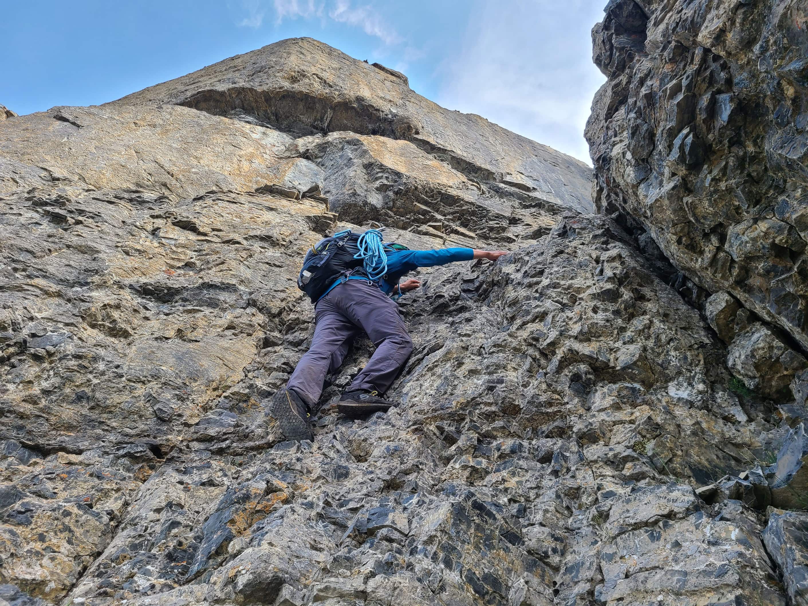
This section looked doable, but we deferred to climber’s left.

Andrew searches for a way up.

This was a bigger detour than we expected, but it was nice to be in the shade.

The limestone band is dead ahead.

Regaining the ridge.

What a fantastic day to be on a mountain! 😁

Peering down from the top of a small chimney. (Photo by Andrew Nugara)

Andrew climbs the same chimney.

A better view of the false summit and the limestone band beneath it.

A cool pattern on the rock.

As I mentioned in my Dungarvan post, I’d rather face a limestone band than a Finnish Death Metal Band any day of the week. 😂

Back on the ridge and looking across to Dungarvan (left), “Rogan Peak” (centre), Galwey North (right of centre) and Mount Galwey (right)

The limestone band is formidable and there does not appear to be an easy weakness anywhere on the south face of the mountain. We identified three routes to climber’s left of the ridge: the first being a possibility; the second being the one we used; and a third that looked to be a hundred or so metres away, but which we didn’t explore.

Checking out our first option. It was possible, but the second looked even better. (Photo by Andrew Nugara)

Inspecting our second option. It may only be ~ 3.5 m tall, but it’s a nail-biter. (Photo by Andrew Nugara)

The second weakness can be identified by the pointy rock formation at the top. This is where Andrew ascended in 2016.

Andrew leads the way.

The tricky part is encountered about halfway up – where you find yourself perched precariously as you cross from one side to the other.

As you can see, the holds are rather small. I would not want to down-climb this without a rope – which is why we brought one, just in case. 😳

Andrew’s view as I tackle the hardest part. (Photo by Andrew Nugara)

Whew! Now above the limestone and looking down on the ridge.

From here, it’s nothing but easy scrambling to reach the false summit.

A better look back along the ridge.

Standing on top of a cool little window. I was too lazy to climb down to it. (Photo by Andrew Nugara)

The always popular, Castle / Waterton lichen photo. 😊

Nearing the top of the false summit.

The true summit is an enjoyable ~630 m ridge walk from here.

Looking back to the false summit.

Getting closer. (Photo by Andrew Nugara)

A pano from my vantage in the previous photo.

Looking over to our next objective for the day, Cloudy Ridge (right).

The super cool, stegosaurus-like summit of Dungarvan.

Another view back to the false summit.

While this could be easily bypassed to climber’s left, we opted to head climber’s right to check out the argillite.

My view down to Andrew after scrambling a nice line of argillite.

Reaching the summit is an easy stroll from here.

The summit of “Dundy Peak” (2432 m) – or as I’ve taken to calling it, “Alligator Dundy”. 😂

Andrew joins me on the summit.

A pano to the east…

Followed by pano to the south…

Then one to the west…

And finally, one to the northwest.

Where we were a week ago: Mount Dungarvan.

A closer look at Dungarvan’s unique summit.

Zooming in on “Rogan Peak”.

Looking across to Galwey North and Mount Galwey, with Sofa Mountain in background.

A hazy view of Mount Crandell.

Ruby Ridge was a fun trip!

Piinaquiium / Ahkoinimahstakoo (Mount Blakiston) is on my list for 2021. EDIT: done!

A telephoto of Anderson Peak.

Gazing along the connecting ridge to Cloudy Ridge (right of centre).

And finally, a closer look at “Cloudy Junior”.

After a brief stay on the summit, it was time to leave. Click to continue on to Cloudy Ridge.


Leave a Reply