
⚠️ Hiking and scrambling are inherently dangerous activities. Please read my Disclaimer. ⚠️
After busy schedule of work and volunteer activities, it was good to get back to the mountains for a recharge. 😁 One particular piece of unfinished business that I’ve had on my list for quite some time, has been the middle peak of Loaf Mountain – or “Pastry Peak” as I’ve taken to calling it. Completing this tasty objective would mean that I could finally say that I’ve enjoyed the entire ~ 9 km long delicacy that is comprised of: “The Muffin”, “The Croissant”, “Bakery Peak”, “Pastry Peak”, and of course, the summit of Loaf Mountain itself.
As with many of the mountains in the Castle, Loaf offers fantastic opportunities for year-round exploration, with multiple routes accessible from either the Bovin Lake trail or the Spionkop Valley trail. I’m always shocked when I meet people who say that they only visit officially named summits, because some of my best trips have been on subsidiary peaks. Oh well, each to their own. 😁
This trip was especially memorable because it was my first peak as a grandpa. Yes, you heard that right, Melanie and I are now the extremely proud grandparents of Oliver – and he is the cutest baby ever! Watching my son, Nathan, and his wife, Chantelle, adapting to parenthood has been cool and we’ve enjoyed lots of time holding and snuggling little Ollie. That Nathan is already planning a climbing wall for Ollie, bodes well for his future in the mountains. 😁
Joining me today were Andrew and Brad – two of my favourite people to explore mountains with. Outside of our conversations, what made the day so enjoyable, was our ability to take advantage of ideal snow conditions. Hard-packed snow made our ascent much easier – and much more scenic – than we were expecting. In fact, it didn’t matter if it was on the mountain or in the Spionkop Valley, the snow functioned as the perfect medium for travel. This is one of the reasons why I love scrambling in the spring.
Now that I’ve tasted everything Loaf has to offer, does that mean I’m full? Not a chance! I’m sure I will be back because who can resist such a delicious assortment of fine baking? 😁
Be sure to read Andrews trip report!

To get to the northeast end of Loaf, we drove ~19.5 km south from Pincher Creek on Highway 6 until we reached the Shell Waterton Plant Road (Township Rd. 43A). We then turned onto it and drove west for ~9.1 km until we came to a junction with a gravel road near to the entrance of the plant. Here, we turned left and onto a gravel road where we continued for ~3.9 km until we reached Butcher Lake. We then turned left and onto another gravel road immediately prior to the Lake and followed this road for ~1.4 km until we come to the junction with another road on our left. We turned here and followed it for ~5 km until we arrived at a T-intersection. We turned left again and proceeded for 700m until we could see a hairpin curve on our right. We follow the curve and drove for ~3.5 km until we reached yet another T-intersection. Here, we turned right and drove for ~800 m until we reached a fork in the road. To our right was the gate for the road that leads up the Spionkop Valley. This is the trailhead.
From the trailhead, we biked for ~3.9 km until the road forked. We kept to the right and continued on for another 700 m until we came to the end of the road and the point where the Spionkop Valley trail continues into the trees. In total, it was ~4.7 km from our vehicles to this point.
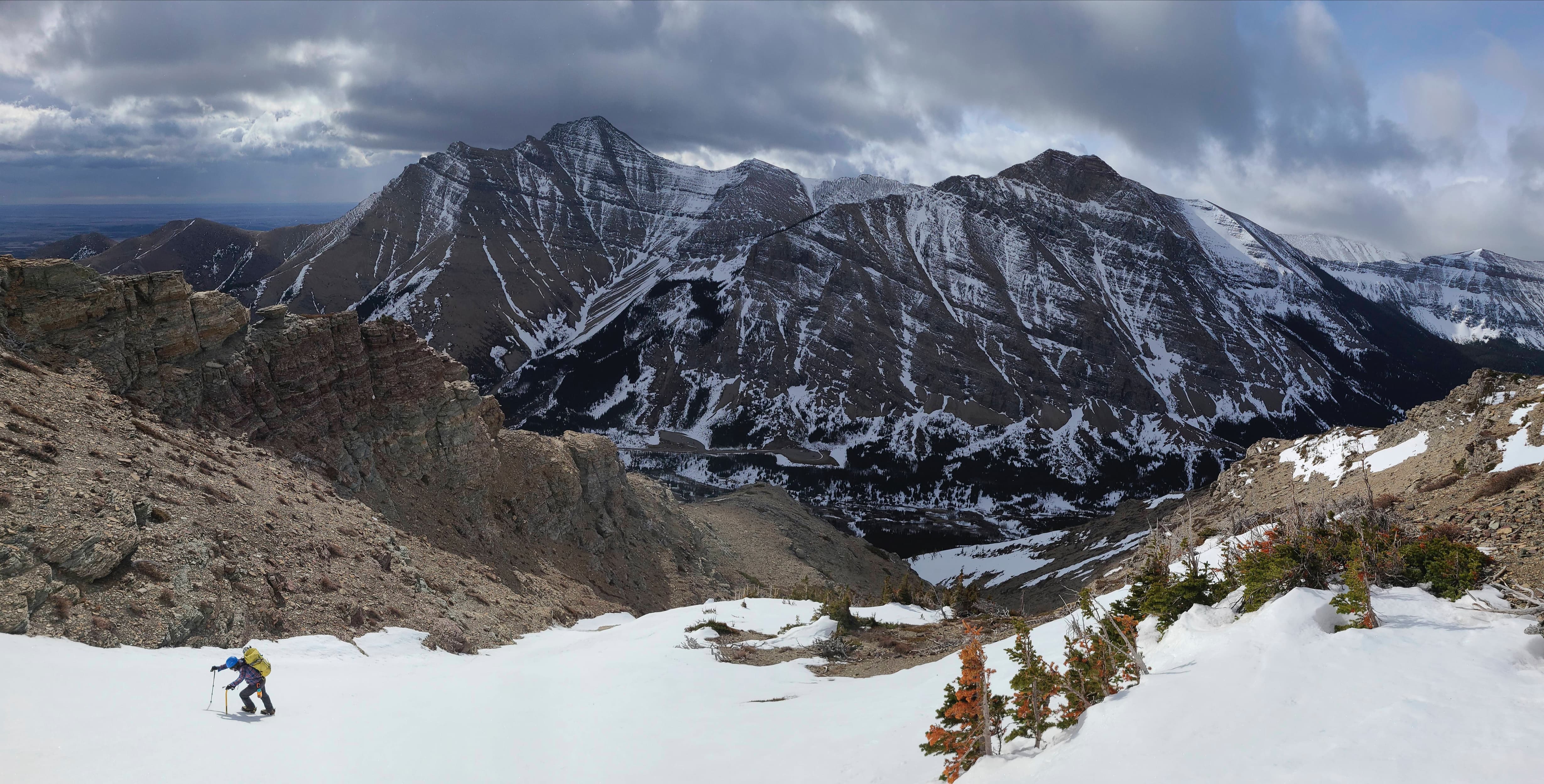
From the end of the road, we headed immediately upwards and into the trees, eventually following a small ridge located between “Bakery Peak” and “Pastry Peak”. From the road to the main ridge it was a 670 m elevation gain over ~3.8 km. The crux was getting past the massive limestone band that guards the upper half of the mountain. This entailed some partially exposed scrambling up a route located to climber’s right from where we encountered it on the small ridge. Once above the crux, it was a delightful hike up snow-filled gully to the main ridge of Loaf.
Once on the main ridge, it was a ~790 m hike to reach the northeast face of “Pastry Peak”. From here, we headed climber’s left until we came to a very obvious snow-filled couloir that led to the summit. We then followed it to the top.
To descend, we followed the broad ridge that leads from “Pastry” to the summit of Loaf Mountain. Approximately 3 km from “Pastry” we came to the col between a high point and the summit of Loaf Mountain. Here, we descended down easy scree slopes while trending skier’s right to avoid cliff bands.
After ~1.8 km, we arrived in the bowl beneath the east face of Loaf, and from here, we hiked for another ~2.2 km until we came to the Spionkop Valley trail. Once on the trail, we followed it for ~3 km until we arrived back at our bikes and the gas road. We then enjoyed an incredibly quick, ~4.7 km bike ride back to our vehicles.

Our total distance travelled was 23 km with total elevation gains of 1171 m. Our total roundtrip time was 8 hours and 5 minutes. *Note: my GPS was functioning about ~140 m off of the actual elevation (must’ve used too much yeast 😂). The actual elevation of “Pastry” is 2464 m.

How cute is this!! Our first grandchild, Oliver, was born in March. My son is already planning to build a climbing wall, so I’m sure Ollie will grow up with a great love for the mountains – and of course, lacrosse! 😁

Gearing up at the Spionkop Valley / Creek trailhead. The forecast was iffy, but it turned into an excellent day, with the snow holding off until we were on back on the trail at the end of the day.

We biked the first ~4.7 km along the road – which was a life saver at the end of the day. 😁

Andrew pauses to scope a new route up, “The Croissant”.

Andrew and his Vespa scooter – er, e-bike 😂 – wait for us near the end of the road. At this point, Brad and I were pushing our bikes up the hill.

Andrew and Brad discuss a possible route to “Pastry Peak” which can be seen directly above Andrew. As Andrew has done “Pastry” before (2013 trip; 2020 trip), we wanted to use a route that he had never tried. The Spionkop Valley trail starts into the trees on the left side of the photo.

Stashing our bikes near the gas well. Our route would eventually utilize the snow-filled gully that is visible in the top centre.

Andrew leads the way.

A quick look back at the well site and the location of our bikes (bottom centre).

A positive sign of things to come: hard-packed snow. 😁

Beginning an enjoyable ascent.

A wider perspective of the previous photo. “Raptor Peak” and Spread Eagle Mountain are in the background.

Brad passes in front of “Bakery Peak” which is located on the northeast end of Loaf. As you can see, it is comprised of bread sticks standing on end. 😂 Seriously though, it is one of the cooler peaks in the area.

We stuck to the snow as long as we could. (Photo by Andrew Nugara)

I arrive at the first of many colourful features. (Photo by Andrew Nugara)

I may now be a grandpa, but that doesn’t mean I’m giving up scrambling. 😂 (Photo by Andrew Nugara)

My view upwards from the previous photo. I’m always a sucker for those Castle colours!

More unnecessary scrambling. (Photo by Andrew Nugara)

My view back with Spionkop Ridge in the background.

Arriving at the crux. Many mountains in Waterton and the Castle have a limestone band that guard the upper slopes, and more often than not, getting past these turns out to be the most difficult part of the day. (Photo by Andrew Nugara)

Brad looks to tackle it head on, while I head to climber’s right. Usually, we can always bet on Brad to find a route… but can we today? 🤔

I start to explore my own route… (Photo by Andrew Nugara)

Brad is an insanely good scrambler. (Photo by Andrew Nugara)

However, he can’t find a way up the final few metres. (Photo by Andrew Nugara)

Meanwhile, Andrew continues past my location and follows the band quite far to climber’s right. Unsuccessful in finding a route, he does come across this very cool waterfall. (Photo by Andrew Nugara)

Wait a minute! How did grandpa Dave get up there? 🤔 (Photo by Andrew Nugara)

My view back to Andrew (centre) in the previous photo.

That’s right! It’s always bet on Dave – at least for today. 😁 Brad follows me up the partially exposed route.

A closer look as Brad navigates the exposure with skill.

Now it’s Andrew’s turn…

And here’s the incredible thing – he climbed it with his crampons still on. Amazing skill!

The remaining section above the crux. We would follow the snow-filled gully in the centre all the way to the top.

The gully is steeper than it looks! (Photo by Andrew Nugara)

Brad’s always game for a snow ascent! 😁

Andrew inspects a small waterfall.

I lead off as we start up the gully. (Photo by Andrew Nugara)

A gorgeous view back and over to Spread Eagle Mountain.

One more for good measure! 😁

Brad leads us towards the Gates of Mordor.

Brad’s view back. Note the very large rock sitting on the snow in front of me. At some point in the recent past, it had careened off the mountain and tumbled down the gully, leaving a deep impression in the snow (foreground). (Photo by Brad Wolcott)

And now my view back to Andrew.

The upper section of Loaf is full of colourful pinnacles. (Photo by Andrew Nugara)

This pinnacle was particularly stunning. (Photo by Andrew Nugara)

Brad’s view just before he dropped his camera. It would roll all the way down the gully and past Andrew, who then climbed back down (as did Brad) to retrieve it. (Photo by Brad Wolcott)

A closer look at that gorgeous pinnacle.

Enjoying the sweet view!

Brad and Andrew make their way up after retrieving the camera. We could now see “Cloudy Junior” and Cloudy Ridge (far right) behind Spread Eagle Mountain.

It was possible to scramble to the top of the pinnacle, but not while wearing crampons, so I took a pass. However, in hindsight, I wish I had removed my crampons and tried it.

Brad begins his double axe ascent of the upper section. (Photo by Andrew Nugara)

Meanwhile, I continue to explore the other side of the pinnacle.

While Brad continues straight up, I opt for a little more security inside the rocks. (Photo by Andrew Nugara)

A cool pano of the previous photo… (Photo by Andrew Nugara)

And then an even cooler one! (Photo by Andrew Nugara)

Brad eyes up the last few metres.

Almost there… (Photo by Andrew Nugara)

And now both of us are on top. (Photo by Andrew Nugara)

Brad enjoys the view while we wait for Andrew.

Glancing along the ridge towards “Bakery Peak”. Note all of the cool pinnacles in the foreground. There is so much to see and explore on this mountain! 😁

On the ridge and noticing that the wind wasn’t as bad as we thought it would be. It still sucked, but it was the normal southwestern Alberta kind of suck. 😂 (Photo by Andrew Nugara)

Next stop: “Pastry Peak”.

“Pastry” looked imposing from the ridge; however, we found a great route via the obvious snow-filled couloir leading to the summit.

From this vantage, you can see how narrow “Bakery Peak” is.

Despite the forecast, the sky remained wonderfully clear.

Approaching the base of “Pastry” and getting a better look at that scrumptious couloir (left). (Photo by Brad ‘Whoops, I dropped my camera!’ Wolcott)

Andrew contemplates whether or not he should purchase e-legs to go along with his Vespa. 😂

I lead us towards the base of “Pastry”. (Photo by Andrew Nugara)

Brad checks out the impressive mix of layers and colour.

Enjoying a quick break.

The colours were incredible! (Photo by Andrew Nugara)

Blue sky + red argillite + yellow lichen = a classic Castle day. (Photo by Andrew Nugara)

Heading towards the couloir. (Photo by Andrew Nugara)

Standing at the base of the couloir.

Andrew leads the way.

Close to the top, Andrew and I elected to take advantage of the rocks while Brad continued up the snow.

Andrew’s view over to Brad and I. (Photo by Andrew Nugara)

Brad powers his way to the top…

And then waits for us on the summit.

Gazing down the couloir.

A pano to the northeast…

And then one to the south…

And finally, one to the southwest. Hmmm, something is missing… 🤔

Ah, yes. That’s what’s missing. The summit of Loaf Mountain was hidden under a cloud.

Looking to the north at Drywood Mountain.

Glancing to the northwest at Pincher Ridge (right) and Victoria Peak (centre).

A closer look at Victoria Peak with the Centre Peak of Pincher Ridge in front of it.

The Southwest Summit of Drywood with Windsor Mountain and Castle Peak off in the distance..

A good look at Spread Eagle Mountain with Mount Yarrow off to the right.

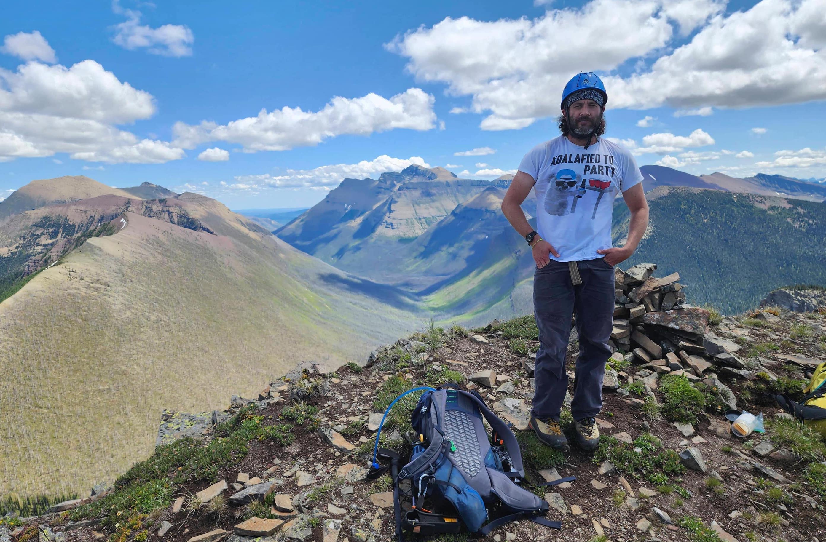
Celebrating a cool peak with awesome friends. (Photo by Andrew Nugara)

Beginning our ~3 km traverse to the base of Loaf.

Looking back at “Bakery” and “Pastry”.

Easy but scenic hiking along the ridge. (Photo by Andrew Nugara)

That’s it! The party’s over kids! 😂 This is definitely one of the weirder items of trash that I’ve collected.

More great scenery.

Our plan was to descend from the col between the high point in the foreground and the small shoulder on the right.

The sky begins to clear over Loaf. (Photo by Andrew Nugara)

A quick look back.

We thought it would be easier to avoid the high point and just traverse to the col. However, it was a much longer side-slope than we were expecting. (Photo by Andrew Nugara)

Arriving onto the col…

And a starkly winter landscape.

Heading down easy scree. We would trend climber’s right to avoid cliff bands.

And just like that, the clouds disappear from the summit of Loaf Mountain.

Passing one of many ice formations. (Photo by Andrew Nugara)

In the bowl beneath the east face of Loaf.

Impressive cornices on the summit!

We startled a herd of sheep…

Prompting them to run away. (Photo by Andrew Nugara)

Enjoying easy travel thanks to the snow…

And getting in a quick glissade. (Photo by Andrew Nugara)

We would only follow the snow for a short ways beyond the bowl…

Before heading to skier’s left to avoid a waterfall.

Searching for a good spot to eat lunch.

Found it!

Taking advantage of good snow to reach the Spionkop Valley trail.

The waterfall on the right is what we avoided, but it is also where Brad comes to ice climb. He camped here in January.

I’ve always had a special place in my heart for this valley.

We now had a ~3 km walk back to our bikes.

One more look back.

It was sunny, but not for long.

Hmmm, the trail has disappeared.

A casualty of winter.

Still searching for the trail.

Found it!

The man, the myth, the mastermind behind the Rusty the Ram Memorial Disc Golf Course. 😂

The weather quickly turned nasty.

Thankfully, we were off the mountain. (Photo by Andrew Nugara)

On the final section of the trail.

Arriving back at the well site…

And our bikes.

I can’t begin to describe how important bikes are for exploring in the Castle – especially at the end of the day, when it’s all downhill. 😁

It took us only 10 minutes to cover the ~4.7 km back to our vehicles, and in that time, we outran the weather and arrived back under blue sky. I know I say it after every trip, but this was a fantastic day in the mountains! I will never get tired of exploring the Castle – especially when I have such amazing friends to share it with. As this was my first peak as a grandpa, “Pastry” will always be memorable to me – though I guess if I’m now a grandpa, my memory may fail and I may soon forget that I’ve done it. 😂


Leave a Reply