
⚠️ Hiking and scrambling are inherently dangerous activities. Please read my Disclaimer. ⚠️
Like other backcountry enthusiasts, I spend an inordinate amount of time looking at Toporama, Google Earth, and other hikers’ websites. I first took note of Loop Ridge when I was compiling my trip report for Mount Erickson in June 2014. I was searching for the name of the long ridge that lay directly to the south of Erickson on the other side of Highway 3. After learning from Toporama that it was called Loop Ridge, I was then surprised to discover that Calgary-based hikers Bob Spirko and Sonny Bou had visited the summit earlier that same month. Since I like destinations off of the beaten path, I made note of their reports (read Bob’s report / read Sonny’s report) and planned my own trip. While Bob and Sonny had made their approach from the south end of the Ridge, I planned an early season trip that would traverse the ridge from north to south.
Though not an overly impressive destination, this trip did have special meaning for me as I had learned the day before that my best friend throughout my teenage years had passed away. Living west of Calgary, we shared many outdoor adventures and Jason was the first person that I climbed a mountain with. He would later stand beside me as the Best Man at my wedding. Though several years had passed since Jason and I last saw each other, we reconnected this past February and talked with an ease that felt as though we were resuming a conversation from just a few days prior. We had planned on getting together this summer when he passed through Alberta. Now in hindsight, the timing of our reconnection was a great gift. I thought about him the entire trip and since my nephew Jeff knew him too, we were able to share stories as we walked and then spent time on the summit remembering him.

The route we took up Loop Ridge can be accessed by driving west on Highway 3 from Coleman, AB and then turning south onto the Corbin Road about ~8.6km from the Alberta/BC border. Drive ~4.7km down the Corbin Road until you come to a small dirt road on your left that leads across the railroad tracks (I think this is the first left turn you can make along the Corbin Road). Turn onto this road and park your vehicle on the other side of the tracks. The road is called ‘Loop Ridge Road’ and will lead to the base of Loop Ridge, however, there is a gate not far beyond the tracks that prevents non-logging traffic from continuing.
We followed the well used logging road for about ~1.2km before leaving it to bushwhack up to an old logging road located on the slopes to our left (north). An easy way to tell where to leave the road is to head into the trees on your left when you come to a giant pile of burned timber on the right hand side of the road. After engaging in some light bushwhacking for ~350m, we came to the old logging road about 1/2 way up the slope. It was almost unrecognizable and full of boulders, but after following it for a few dozen metres, the road’s outline became noticeably clear. We followed the road for ~1km until we came to the base of Loop Ridge. The road is overgrown in several places, but a well used animal trail makes travel easy. Here, the road contains a switchback that leads to the east, but we took an animal trail that led up through the trees until we rejoined the road again at the base of our ascent slope up Loop Ridge. From here we hiked ~450m up the steep slope until we gained the ridge.

Travel along the ridge was not difficult and bushwhacking in the treed sections was fairly light. The snow remaining in the trees was firm enough that we only post-holed on a couple of occasions. From where we gained the ridge to the summit was ~1.9km. We returned the same way.

Loop Ridge sits at 2030m (my GPS) and offers a unique view of the Crowsnest Pass. Our total distance travelled was 10.5km with total elevation gains of 847m. We completed the trip in exactly 5 hours which included a long lunch break once we gained the ridge and a long stay on the summit.

Our parking location just off of the Corbin Road (~4.7km south of Highway 3). Loop Ridge can be seen in the distance though the summit is not visible. The first logging road we followed is visible in the trees just behind my 4Runner.

The logging road is fittingly called ‘Loop Ridge Road’. As Jeff also noted, we needed to be careful due to active logging (as opposed to passive logging).

A gate prevents vehicle traffic up the road, though as we walked by we noticed that it was unlocked.

We passed by several stacks of timber. (Photo by Jeff Lang)

Jeff follows the road towards Loop Ridge. We would soon leave this road and hike ~350m up the slope in front of Jeff to follow an older, unused logging road.

After ~1.2km we left the road and began to bushwhack up the slope on our left. Look for a pile of burned timber on the right hand side of the road as a reference. (Photo by Jeff Lang)

Jeff makes his way up the slope above the logging road. Being tick season, we were thankful that the bushwhacking wasn’t too bad.

After ~350m of bushwhacking, we came to the old logging road.

At times the outline of the road was hard to discern. I was standing in the middle of it to take this picture. We would follow this road all the way to the base of Loop Ridge (~1km).

After coming to a bend, the road began to head north. We followed the road until we came to the bare patch of grass above the trees in the middle of the picture. We then ascended up the rocky slope next to the tree line.

Once it entered the trees, the road became overgrown in many places. Fortunately, a well used animal trail makes navigating through the underbrush quite easy. We were pleasantly surprised to discover that there were no signs of ATV use.

After following the old road through the trees, we finally came to a switchback at the base of Loop Ridge. Instead of following the road, we took a shortcut up an animal trail. Here, Jeff stands on the animal trail next to the road. The size of the trees growing in the middle of the road give some indication as to how long it has been since it was last used for vehicles.

We came across this old tree shortly after starting up the ascent slope.

Jeff powers his way up the steep slope. Behind him at the top of the clearcut is the logging road.

Once we gained the ridge, the views to the west opened up. We learned fairly quickly that you DON’T hike up Loop Ridge for the views to the west. They are rather uninspiring…. The peak second from the left is the Natal Fire Lookout.

A closeup of the old Natal Fire Lookout on the summit of Sparwood Ridge.

From this vantage point, the views to the south along the Corbin Road are also rather poor. The summit of Mount Taylor is visible on the far left.

After gaining the ridge, we then proceeded southward into the trees.

Looking back down at the Corbin Road and our approach route. Three Sisters is the peak on the far left and the Natal Fire Lookout is left of centre.

Jeff pauses to look northward at Mount Erickson. Sheep Mountain and Mount Salter are in the distance to the left of centre.

After making our way through the first section of trees, we were finally able to see why you WOULD want to climb Loop Ridge – for the views to the east and the Flathead Range.

Looking east into the Crowsnest Pass. Crowsnest Ridge is on the left, Sentry Mountain and Chinook Peak are on the right. The South Peak of the Livingstone is in the distance, as is Bluff Mountain and the lower portion of ‘The Saddle’. Island Ridge is in the foreground on the right.

Jeff enjoys the views from along the ridge. The Northwest Ridge of Ptolemy is on the right and Sentry Mountain is on the far left.

A cool picture by Jeff as I walk along the ridge. The final section of trees before the summit is in the background. (Photo by Jeff Lang)

Most of the snow that we encountered was in the trees, but there were still remnants in more open areas.

Another view of the Crowsnest Pass from along the ridge. Mount Tecumseh and Phillipps Peak are on the left and Sentry Mountain is on the right.

Looking north towards Mount Erickson (centre). The High Rock Range is on the right. To the left of Erickson is the coal mining operation on Natal Peak.

Just before reaching the summit, we came across a provincial boundary marker that was partially covered in vegetation.

Jeff examines the marker from the B.C. side, while I stay closer to home on the Alberta side.

Sections of the marker bore the names of hikers, loggers, and surveyors from as far back as 1936.

This one is from 1960…

…while the two above it were from 1936 and 1939. The most recent inscription that we could find was from 2010.

The summit lies a short distance away from the first boundary marker. Tent Mountain is on the left.

The summit of Loop Ridge (2030m).

Loop Ridge offers a unique view of the Crowsnest Pass. From left to right: Phillipps Peak, Mount Tecumseh, Crowsnest Ridge, Island Ridge, and Sentry Mountain. The snow covered shape of Centre Peak on the Livingstone Range can also be seen in the distance.

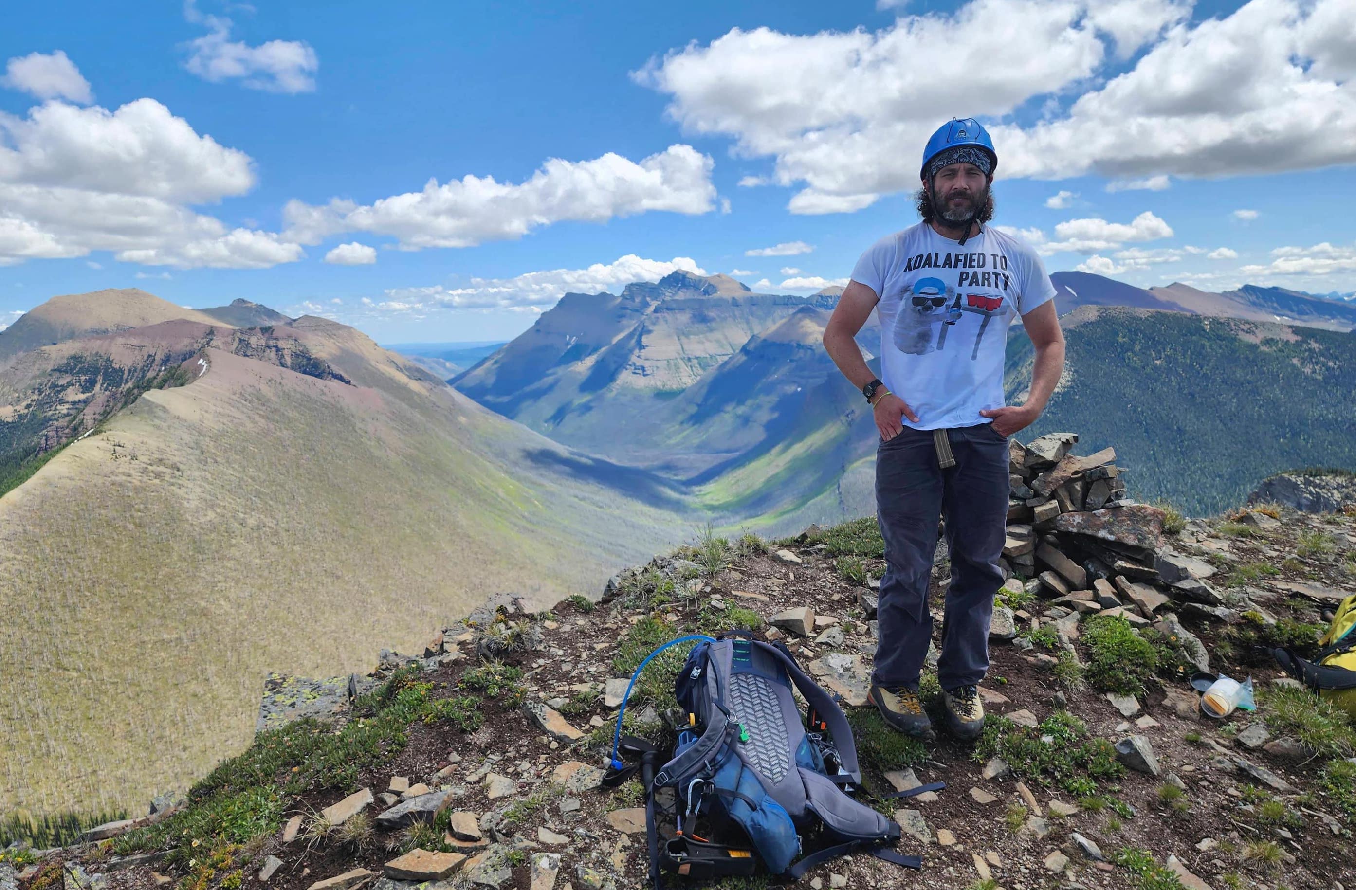
Jeff and I on the summit with the Flathead Range behind us.

A behind-the-scenes look at the making of our summit pose. I improvised a tripod for my trusty old DSLR by using our hiking poles.

A panorama of the view to the east. Mount Ptolemy is right of centre and Tent Mountain is on the right.

A closer view of the Flatheads. Andy Good Peak and Mount Coulthard are in the distant middle. The three peaks on the Northwest Ridge of Ptolemy can be seen on the right.

The Northwest Ridge of Ptolemy and Mount Ptolemy are on the left and Tent Mountain is right of centre.

The view to the south. Tent Mountain is on the left, Michel Head is in the centre, and Mount Taylor is on the right.

Looking northeast towards Mount Tecumseh, Phillipps Peak, “Deadman Peak”, “Shooting Star Peak” and “Alexander Creek Mountain”.

Looking north at Mount Erickson (left) and “Alexander Creek Mountain” (right).

Just in case you were wondering what the blue sign was…

The views to the west are not as engaging. Three Sisters and Mount Hosmer are on the left and the Natal Fire Lookout is in the centre. The tall peak on the right is Mount Washburn.

Jeff walks the line with his left foot in B.C. and his right foot in Alberta.

Most of the names on the summit boundary marker had faded away, but some were still visible. I decided to add our names along with a small tribute to my friend Jason.

Jeff pauses for one last look at the boundary marker before we leave. To return we retraced our route.

Making our way down the slope to the old logging road.

Heading back along the road. (Photo by Jeff Lang)

Looking back at our ascent route.

We followed the old logging road back and then bushwhacked down to reach the main road. When ascending, a good place to know when to leave the road is to use the pile of burnt timber (pictured) as a reference point.

Our parking location off of Corbin Road. Though the views to the west are not that inspiring, the views to the east make Loop Ridge an interesting and worthwhile hike.


Leave a Reply