
⚠️ Hiking and scrambling are inherently dangerous activities. Please read my Disclaimer. ⚠️
This was a fantastic trip! Not only did the weather cooperate, but the challenges posed by route finding and scrambling undoubtedly kept senility at bay for a couple of 50-something guys. 😂
“Cloudowan Peak” is the nickname that Andrew and and his brother, Mark, gave to the prominent, unnamed summit (GR165500) located between Cloudy Ridge and Mount Glendowan – “Cloudowan” – in Paahtómahksikimi (Waterton National Park). This was back in 2007 and as there were several sections requiring the use of rope, Andrew has kept “Cloudowan” out of More Scrambles in the Canadian Rockies. In fact, today was the first time he’s attempted to follow up on his observation that, “the entire ascent could have been scrambled if one desired to do it without a rope.” That there is little, if any, additional information on “Cloudowan” speaks to both a lack of interest and perhaps difficulty.
Therefore, with a forecast warning of severe thunderstorms and an early morning whopper that proved this wasn’t a joke, Andrew and I set off from Red Rock Canyon knowing full well, that we might have to bail due to weather or insurmountable rock – or both. Following his previous route, we headed up “Cloudowan’s” surprisingly scenic south ridge that is easily accessible from the Snowshoe trail. Indeed, even if the intent was never to go up “Cloudowan”, a trip along the lower portion of this delightful ridge would not disappoint those looking for a view.
Soon after reaching the scrambling section of the ridge, it became apparent why Andrew had noted that the rock bands were far more serious than those of Glendowan and Mount Dungarvan. Not only was the scrambling more difficult, the rock was untrustworthy – and in many cases, wet from snow melt. In fact, throughout the day, I made numerous attempts at scrambling different routes, only to turn back in the hope of finding an easier track – which with patience, always presented itself.
Indeed, patience and perseverance are the keys to unlocking “Cloudowan” as a scramble and nowhere was this more evident than when it came to the summit block, which proved to be crux of the entire trip. Since Andrew couldn’t recognize the route that he and Mark had used in 2007 – only that they didn’t require a rope to down-climb it – we set about traversing the base in search of a way up. After reaching the northeast end of the block and finding no obvious or inviting route, we resigned ourselves to the idea that we had reached the ‘scramblers summit’ and not the actual summit.
However, on the way back we paused for a closer look at two possible routes that we previously noted, but bypassed in the hope of finding something better. Not wanting to give up on reaching the summit, I made it halfway up the second route before turning back due to a combination of wet moss and rock. Had it been drier, this route would certainly have worked, though it was highly exposed and down-climbing was tricky. Just around the corner, we came to the first possibility – a narrow couloir with a slightly easier grade and less exposure. Taking one last chance on finding a route to the top, I soon found myself making rapid progress, eventually finding my way onto the summit. We had ‘rediscovered’ the route used by Andrew and Mark in 2007. 😁
Though not an official summit, “Cloudowan Peak” was worth the effort simply for the views. There are also two summits on the ridge – the southwest pinnacle that we tackled today and a ‘milder’ summit on the northeast end that according to the Avalanche Canada topo, is slightly smaller. With its rugged prominence on the skyline, “Cloudowan” is no shrinking violet nor is it any less worthy than Glendowan or Cloudy Ridge. It is however, an objective that requires a high level of experience and skill due to all the route finding combined with the nature of the scrambling.
Again, a HUGE thank you to Andrew for yet another wonderful adventure in the mountains! 😁
Be sure to read Andrew’s awesomely fantastic trip report!!

To get to “Cloudowan Peak” we parked at Red Rock Canyon and hiked the Snowshoe Trail for ~500 m until we came to the open, grassy slopes of “Cloudowan’s” south ridge on our right. This is where we left the trail for an enjoyable ~ 1 km (~250 m elevation gain) hike onto the crest. We then followed the ridge for another ~ 1.3 km until we came to where the terrain changes from vegetation to rock. Shortly beyond this, is where the scrambling begins with the first major obstacle sitting approximately 500 m away.
Patience and perseverance are the keys to unlocking “Cloudowan” and where Andrew and Mark had used ropes in 2007, we were able to find bypass routes to climber’s left. As with most mountains in the area, the limestone band once again posed a significant problem to our ascent. Its presence on the ridge was formidable and we were forced to follow its base climber’s left for ~300 m or so, until we found a gully that we could safely exploit.
This detour took us onto the southwest side of the mountain where we were presented with continuing towards the col with Glendowan or continuing more or less, straight up. We chose the latter, which ended up being a good decision as we could take advantage of the numerous scree ledges to eventually reach the summit ridge. Indeed, later in the day, the southwest scree slopes proved ideal for descent.
The summit ridge is comprised of a series of smaller pinnacles with the obvious summit block located ~450 m from the start of the ridge. The route onto the summit is not obvious, but we eventually discovered that it is the second couloir beyond the narrow gap between the summit block and the large pinnacle immediately to the southwest. In comparing our photos from today with those from Andrew’s 2007 trip, the couloir is marked by a distinctive overhang of pointy rock located immediately above a section of chockstone approximately halfway up.
We did discover a second scramble route just beyond the couloir, but it was far more exposed. I made it halfway up and turned around due to wet rocks and moss; however, under different conditions it would’ve yielded, though the couloir is by far the better – and safer – choice.
After enjoying the amazing views, we returned the way we came, discovering that we could bypass most of the scrambling on the ridge by descending much lower from the limestone band and then traversing downwards until we were back on the gentle grade of the initial section of the south ridge. From here it was a pleasant hike back to the trail and then our vehicles.

Our total roundtrip distance, including our traverse of the summit block and the many test scrambles, was 16.7 km with total elevation gains coming in at 1263 m. Our total roundtrip time was 8 hours and 49 minutes.

Our starting point in the Red Rock Canyon parking lot. The grassy slope in the background leads onto the south ridge of “Cloudowan”. Unfortunately, clouds have obscured the summit from view.

Crossing Red Rock Canyon early in the morning. When we returned later in the day, there were the usual crowds of people along the creek.

Easy hiking along the Snowshoe trail.

Approximately 500 m from the trailhead (~540 m from the parking lot) we came to the start of the grassy slope that leads onto the south ridge. This is where we left the trail.

The grass was soaking wet after an early morning deluge.

Andrew finds himself in natural camouflage as he walks past some arrowleaf balsamwood.

It wasn’t long before we were treated to some great views!

Wooly weed is an appropriate name.

Silky phacelia.

Nearing the ridge crest.

Looking back at Mount Blakiston. Recent scholarship by Dr. Ninna Piiksii (Mike Bruised Head / Chief Bird) has uncovered that the Blackfoot had two names for this mountain. The first is Piinaquiium or “seen from afar mountain” and the second is Ahkoinimahstakoo or “pipestone mountain”.

The summit of “Cloudowan” is true to its name! 😂 (Photo by Andrew Nugara)

On the south ridge and enjoying a more comprehensive view of “Cloudowan”. (Photo by Andrew Nugara)

Easy and enjoyable hiking.

Some great views continue to emerge. 😁

Gazing across to Cloudy Ridge (left) and “Dundy Peak” (right).

The south face of “Cloudowan” has some interesting striations

Getting our first clear view of the summit.

Coming to the bend in the ridge.

Approximately 1.3 km from where we gained the ridge, we came to where the terrain changes from vegetation to rock. Shortly beyond this, is where the scrambling begins with the first major obstacle sitting approximately 500 m away.

A good look at Anderson Peak.

Gazing back along the ridge. The lower portion of the ridge is scenic trip in and of itself.

Andrew leads the way.

Getting our first look at Mount Glendowan.

Climbing up and over a small obstacle. (Photo by Andrew Nugara)

Now comes the serious stuff.

Gearing up for some exploring.

I attempt to follow Andrew and Mark’s route from 2007.

The first of many, “I could do this, but should I?” moments.

Not knowing if I will eventually have to backtrack and down-climb makes me change my mind. Patience is key on this mountain.

Traversing climber’s left along the base of the first cliff band.

Andrew changes his mind after trying to navigate the gap between rock and snow.

Eventually we came to the end of the cliff band and could see the ridge above.

Making our way up to the ridge.

Back on the ridge and looking towards the next obstacle. The summit is directly in the centre.

Looking south from the ridge…

And now slightly to the southwest.

Gazing west from the same vantage.

Andrew (centre) pauses to look back at me…

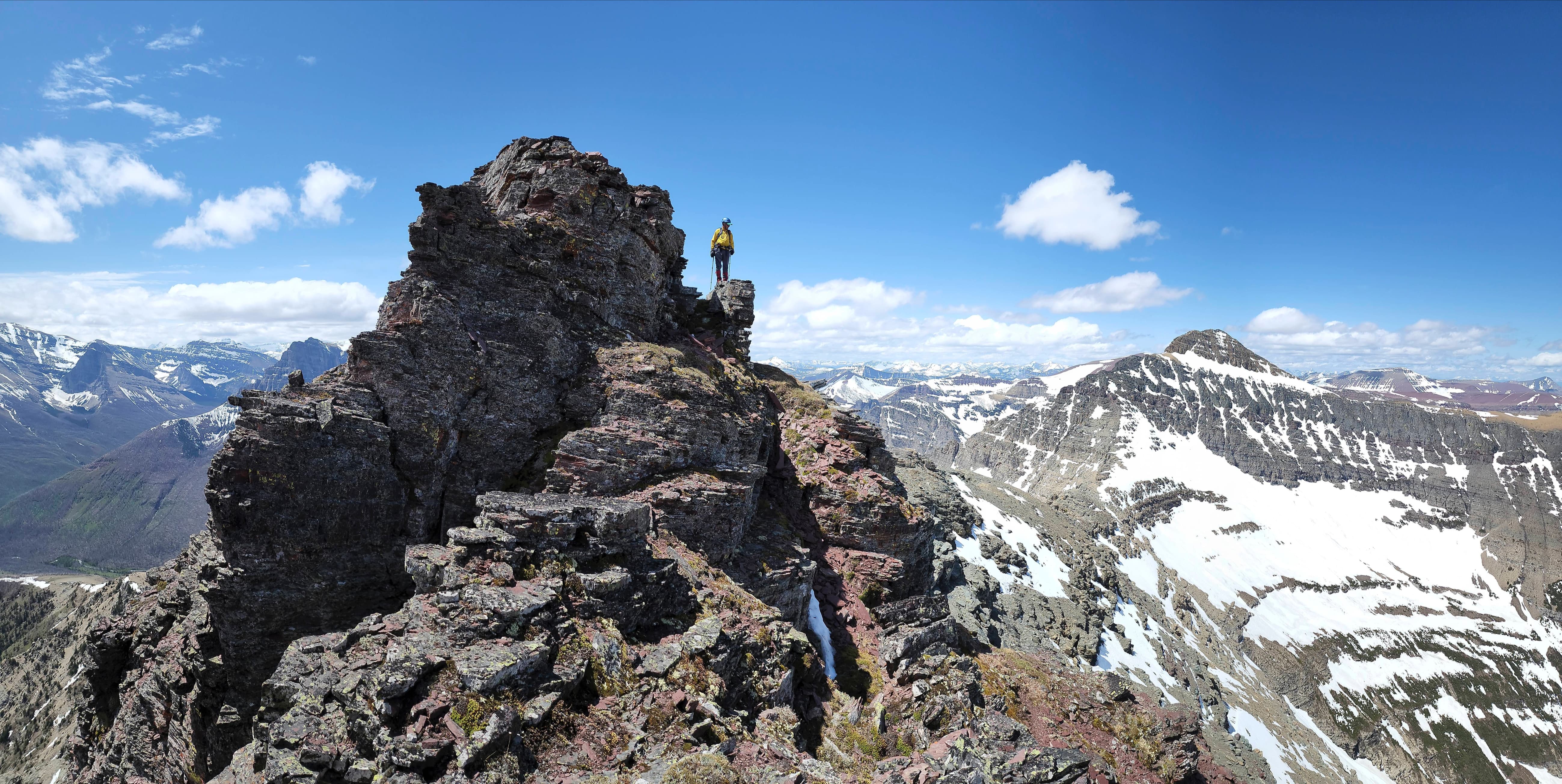
And this is what he sees. (Photo by Andrew Nugara)

A pano of the previous photo. (Photo by Andrew Nugara)

Heading towards the second obstacle. (Photo by Andrew Nugara)

We would end up using a snow gully on the left.

I pause to contemplate a route… (Photo by Andrew Nugara)

Before heading climber’s left to check out the gully. (Photo by Andrew Nugara)

Perfect snow for ascending. (Photo by Andrew Nugara)

Andrew follows close behind.

Continuing up the gully. (Photo by Andrew Nugara)

Looking back.

It would’ve made life easier had the snow had filled the entire gully, but as annoying as the short gap was, it was not difficult.

Andrew tackles the gully’s upper section.

Back on the ridge and looking at the third obstacle: the always challenging limestone band. Though to be fair, I’d rather face this than a Finnish Death Metal band. 😂

The band becomes more formidable the closer we get. (Photo by Andrew Nugara)

Yikes! This one’s nasty! (Photo by Andrew Nugara)

I know a climber or two who would appreciate that crack – but maybe not the overhang. As we’re on a peak with a hybrid Irish name, I will simply say, that is great craic! 😂 (Photo by Andrew Nugara)

We knew from Andrew’s 2007 trip, that there was a weakness beneath the col with Mount Glendowan. However, that was a LONG ways off and so we began to look for an alternative.

The first possibility we came to was the 5.4 pitch that Andrew and Mark used in 2007. Needless to say, we kept going.

Heading up and over a steep block of snow…

Followed closely by Andrew.

Rounding the corner and hoping to find a weakness.

Surveying the options. We would soon find a gully cutting through the rock in the centre. (Photo by Andrew Nugara)

Trying another possibility before discovering the gully. Wet and slippery rock negated what otherwise might have worked. (Photo by Andrew Nugara)

Approximately 300 m from the south ridge, we arrive at a usable gully. (Photo by Andrew Nugara)

Climbing alongside a small waterfall. (Photo by Andrew Nugara)

Looking back from the top of the first section. We would cross the waterfall twice as we made our way up. (Photo by Andrew Nugara)

Andrew starts up the gully.

The washboard rock not only looked cool…

It made crossing the waterfall much easier! (Photo by Andrew Nugara)

A closer look at the interesting rock. (Photo by Andrew Nugara)

Leaving the gully above the waterfall.

We had two options from here: 1) continue to trend climber’s left and make our way towards the col with Glendowan; or 2) traverse the base of the next cliff band and look for a route up the southwest side. We chose the second based on a hunch.

The south ridge is skyline, but we were hoping that a route would present itself near the centre. (Photo by Andrew Nugara)

Andrew makes his way across a steep patch of snow.

Andrew’s view back highlights the immensity of the cliff band. I’m not sure about you, but I definitely see a skull looking down on me from the right. 💀 (Photo by Andrew Nugara)

Or hunch worked! We discovered a weakness along with what appeared to be a good route up the southwest slope.

Taking advantage of some convenient steps. (Photo by Andrew Nugara)

Andrew follows a small gully next to the cliffs.

Andrew’s view up to me. (Photo by Andrew Nugara)

While Andrew more or less followed a straight line to the top, I trended climber’s right and towards the south ridge.

Andrew’s perspective shows me (top left) standing on the south ridge. (Photo by Andrew Nugara)

My view back to Andrew. The scree will later prove ideal for a quick descent.

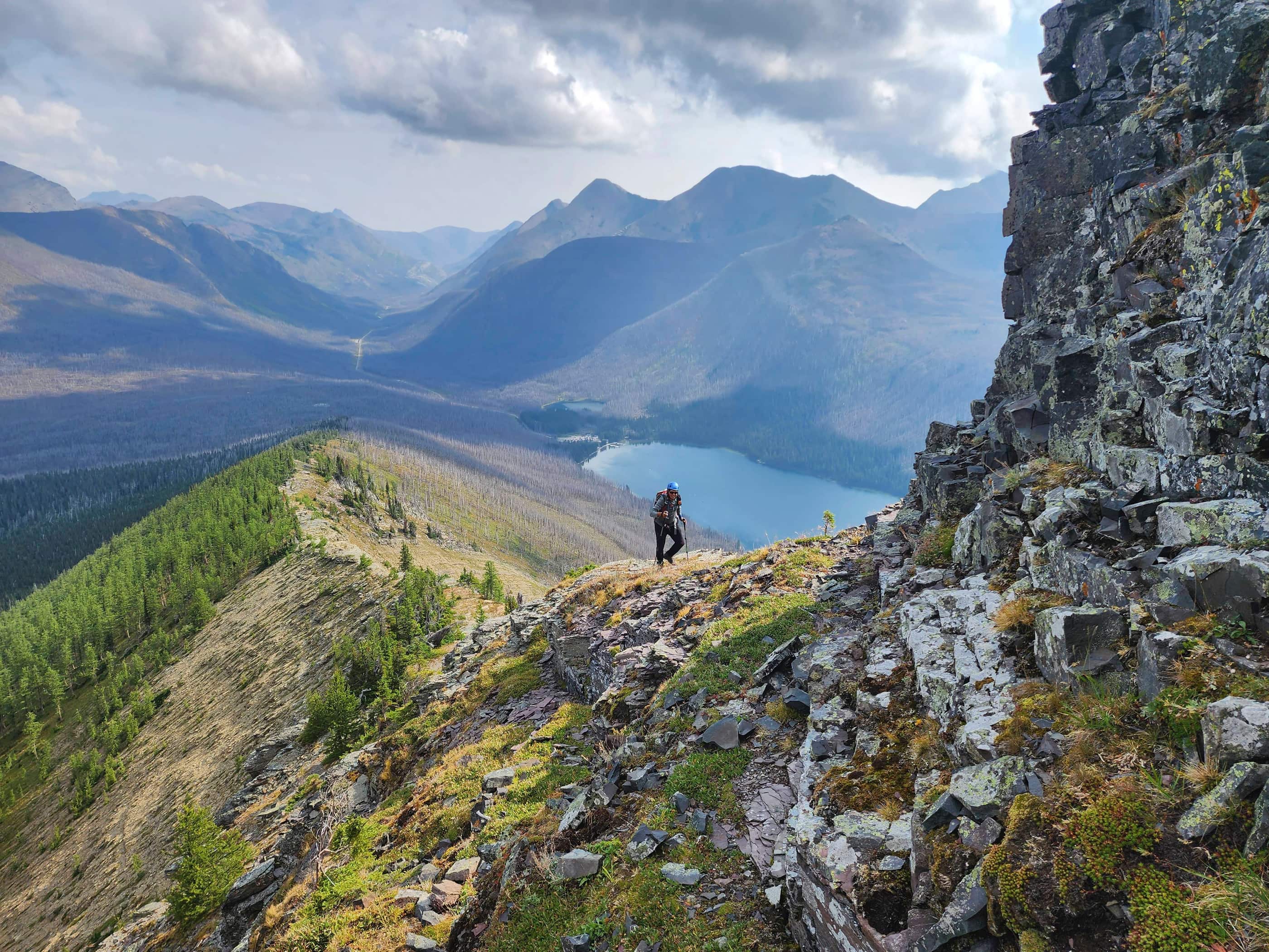
Gazing back and along the south ridge.

The final portion of the south ridge was not difficult.

Andrew (lower right) is dwarfed by the magnitude of Mount Glendowan.

Arriving on the summit ridge and getting our first good look at the summit.

Glancing down the connecting ridge with Glendowan.

Nice views onto the front range of Tatsiki-Miistáki which is Blackfoot for ‘Middle Mountains’ a.k.a the Castle.

A pano to the north with the summit of “Cloudowan” on the right.

Starting along the ridge.

A small patch of moss with a big splash of colour.

The summit ridge is a series of narrow pinnacles…

With lots of options to bypass.

Andrew’s view back from the previous photo. (Photo by Andrew Nugara)

The slightly lower northeast summit is on the far left.

A crown of red argillite.

Climbing back onto the ridge… (Photo by Andrew Nugara)

Followed by Andrew.

Mindful of a severe thunderstorm warning, we were grateful for the continued blue sky.

It was hard to not take a bazillion photos of Mount Glendowan. 😁

Looking to the northwest at Victoria Peak.

One of my favourite scrambles is “Bakery Peak” (right of centre) which sits on the northeast end of Loaf Mountain.

Little snow remains on Spread Eagle Mountain (left) and Mount Yarrow.

Drawing closer to the summit block – which is really a ginormous pinnacle. Note the slightly smaller pinnacle in front along with the gap in between.

The couloir to the summit is found shortly after passing the gap (right of centre) between the summit and the smaller pinnacle. We noticed the couloir, but because Andrew wasn’t sure if this was the route he used in 2007, we kept traversing along the base. It is easy to miss and rather uninviting from the base.

Approaching a steep patch of snow and ice in front of the gap. (Photo by Andrew Nugara)

A slip here would not be good.

The second potential route we came to and the first one I attempted after returning from the northeast end of the base. At this point however, we just kept going.

Andrew (right) leads us along the base.

There are some cool pinnacles further to the northeast.

Looking back to Andrew as we continue our traverse.

Taking advantage of the snow.

Arriving at the northeast end of the summit block with no easy or obvious route in sight.

We debated continuing to the northeast summit, but decided against it.

A great view of “Cloudy Junior” (left), Cloudy Ridge (centre), and Mount Dungarvan (right) from the northeast end of the summit block.

Another view of the ridge as Andrew searches for a potential route up the south face. (Photo by Andrew Nugara)

I stand at the bottom of a potential route. I went up about 3m before realizing it was a dead end. (Photo by Andrew Nugara)

Resigning ourselves to the idea that we had reached the ‘scramblers’ summit and not the actual summit.

Retracing our route along the base.

Not wanting to leave without a fight, I start up the second route we came across. (Photo by Andrew Nugara)

I made it about halfway up, but wet rock and moss made me hesitant to continue. Under dry conditions, this route would work, but it is highly exposed and tricky to down-climb. (Photo by Andrew Nugara)

Making a cautious down-climb. (Photo by Andrew Nugara)

Shortly after my defeat on the second route, I make an attempt at the first route we encountered – a small couloir that is easy to miss but way less exposed. (Photo by Andrew Nugara)

I make rapid progress towards the top. Note the distinctive pointed rock at skyline. When comparing photos from today with those from Andrew’s 2007 trip, this rock confirmed that it was the same route. Though Andrew and Mark were roped for their trip, they did not need it while down-climbing. As a scramble, I was far more comfortable with this route over the other.

For reference, here is Andrew’s photo of the couloir in 2007.

The summit of “Cloudowan Peak” (2570 m) and the highest point on the ridge. The summit is comprised of twin bumps of equal height.

The view to the east…

And then to the southeast.

Gazing southwest…

And now a little more to the west.

Looking directly west…

And then finally to the north.

A closer look at “Cloudy Junior” and Cloudy Ridge (foreground right of centre).

Mount Dungarvan is a fun scramble.

A slightly different composition that includes Mount Dungarvan (left), “Rogan Peak” (centre) and “Dundy Peak” (foreground right of centre).

Zooming in on Mount Galwey (centre) with Istiikoiistakoo (Sofa Mountain) and Ninastako behind it.

Mount Crandell in the centre.

Gazing towards Piinaquiium / Ahkoinimahstakoo (Mount Blakiston).

Dark clouds begin to gather over Anderson Peak.

Zeroing in on Kishinena Peak (centre) with Kenow Mountain behind it.

Still can’t get enough of Mount Glendowan.

Looking over at Loaf Mountain.

Light rain falls on Victoria Peak (centre) and the Southwest Summit of Drywood (left).

Scrumptious “Pastry Peak” (centre) with the summits of Pincher Ridge (left) and Drywood Mountain behind it.

Like a lightbulb in an Easy Bake Oven, sunlight illuminates “Bakery Peak” (right of centre). 😂

Another look at Spread Eagle Mountain (left) and Mount Yarrow.

Looking towards the northeast summit (left of centre) with “Cloudy Junior” and Cloudy Ridge on the right.

Andrew stands on the adjacent summit bump.

A pano of previous photo. This peak was definitely worth the effort!

Andrew’s view over to me… (Photo by Andrew Nugara)

And then a pano of the previous photo. Super cool! 😁 (Photo by Andrew Nugara)

I head over to join Andrew on the first bump. (Photo by Andrew Nugara)

Andrew unleashes ‘Blue Steel’. 😂

Another pano by Andrew, this time to the north. (Photo by Andrew Nugara)

With dark clouds gathering, I begin to down-climb the couloir. It took a several minutes to find the couloir as the top is quite camouflaged. (Photo by Andrew Nugara)

Looking back to Andrew as I near the bottom. Loose rock makes this a one-person-at-a-time endeavour.

Andrew closes in on a narrow section of the couloir…

And makes the tight squeeze through.

Time to head back.

More sweet views from the ridge.

A parting look at the summit. I’m so glad that we persevered with our route finding! 😁

Nearing the end of the summit ridge.

Utilizing ideal scree on the southwest side of the mountain.

We would use the same weakness (lower right) that we did on the way up.

Down-climbing the weakness. (Photo by Andrew Nugara)

Andrew stops for a refill of “Cloudowan Springs”. 😂

Back in the gully at the limestone band. (Photo by Andrew Nugara)

Making the final down-climb off the gully. (Photo by Andrew Nugara)

While it was tempting to drop into the drainage between “Cloudowan” and Glendowan – or even swing over to the approach ridge for Glendowan – we decided to descend almost directly from limestone gully, traversing skier’s left until we were back on the initial section of the south ridge. By doing so, we avoided almost all scrambling.

Keeping an eye on the weather as we descend.

Getting closer…

And closer.

Arriving on the lower portion of the south ridge.

From here to the parking lot it was easy peasy. 😁

Looking back to the summit. This was a such a fun trip!

A pasqueflower with “Cloudowan” in the background.

We could see that it was raining hard to the south, but thankfully, we only felt a few drops and that was it. 😊 (Photo by Andrew Nugara)

Leaving the ridge.

More silky phacelia.

Jacob’s ladder and silky phacelia.

Definitely feeling those Sound of Music vibes. 😂 (Photo by Andrew Nugara)

A tranquil place. (Photo by Andrew Nugara)

More of the same. (Photo by Andrew Nugara)

Almost at the Snowshoe trail.

Back on the trail and making the quick walk back.

Arriving back at the Red Rock Canyon parking lot 8 hours and 49 minutes after starting. This was superb trip because of all the route finding and exploring. Though we had resigned ourselves to the idea of not reaching the actual summit, I’m so glad that we persevered. It would’ve gnawed at us to have been so close but not make it – but now we don’t have to worry about that! While “Cloudowan” is not an official summit it’s nevertheless a worthy objective that probably sees few if any visitors. In fact, it was so fun that Andrew and I are already talking about reaching “Cloudowan’s” northeast summit via an approach from Yarrow Creek. 😁


Leave a Reply