
⚠️ Hiking and scrambling are inherently dangerous activities. Please read my Disclaimer. ⚠️
Wow! What a crazy day – and one that could have turned ugly had we not been able to make a quick escape off of the mountain. In fact, I can’t recall ever experiencing such a sudden and wild change in weather like we encountered today. It was absolutely bananas.
Here’s what happened… Our plan was to explore a route along the northeast ridge of “Newman Senior” which sits on the border of Paahtómahksikimi (Waterton) and Tatsiki-Miistáki (Castle). We’ve thought about this trip for quite a while, especially after scoping out the ridge a couple of years ago while climbing Mount Yarrow. It was just too inviting not to try and if everything worked according to plan, we would complete a loop by first tagging, “Newman Senior” (2640 m), followed by, Newman Peak (2515 m). We would then descend back to the Yarrow Creek trail from Newman’s col with Spionkop Ridge and hike the valley back to our starting point.
So, with the most current forecast calling for clouds in the morning followed by clearing in the afternoon, Andrew and I set off from the Yarrow Creek trailhead. After biking – and pushing our bikes – for about an hour (~5.6 km), we arrived at the final gas well and the point where the trail enters the forest. From here, we had a good vantage of the end of the ridge and could further contemplate our plan to ascend its southeast slopes, which still seemed possible.
Setting off on foot, we hiked the trail for ~580 m, until we found the start of a secondary trail that supposedly leads toward the valley located between the northeast ridges of “Newman Senior” and Mount Glendowan. The heavily overgrown trail combined with what looked to be a massive amount of bushwhacking to even reach the valley entrance, gave us reason to pause. We then decided to continue along the trail to check out the northwest slopes. If we didn’t like what we saw, we could always double back.
Hiking a further ~2.2 km, we soon found ourselves staring up at the heavily treed northwest slope. Deciding that it was ‘six of one or half dozen of the other’, we elected to try it. Though the bushwhacking was bad, there were enough breaks from either game trails or natural thinning that it never became demoralizing. We even lucked out and found an easy way past an otherwise imposing cliff band that had been hidden from view along the trail.
Once on the ridge, we settled in to some good scrambling, good views, and an all-round enjoyable ridge walk – just as we had hoped. We took note that the sky was not clearing as forecast and there were intermittent bands of rain much further to the north, yet in our general vicinity, it was all good. However, as soon as we reached col between the final high point and “Newman Senior”, a strong wind picked up and we could now see rain bands to both the north and the south. It also started to get cold.
Several minutes later we arrived on the summit of “Newman Senior” (2640 m) where we were blasted by the wind and an even sharper drop in temperature. Knowing things were about to go pear-shaped, we had little choice but to continue to the col with Newman Peak (2515 m). That’s where things got crazy.
We’re used to hiking in extremely strong winds; however, the wind at the col suddenly – and I mean suddenly – turned frigid and extreme, combining 100 km + gusts with torrential horizontal rain and painful ice pellets. The bare ridge offered no place to shelter and it was next to impossible to open your pack to put on more rain gear – not that it would’ve helped, for in mere minutes we went from being completely dry to completely soaked and freezing. With numb fingers despite our gloves and barely able to stand in the crosswind, we began to shiver. With our planned – and the easiest – descent route located on the other side of Newman Peak, we knew that even if the rain stopped, the frigid wind would turn us into popsicles before we could reach it. In a wise decision, we turned around at the base of Newman Peak and backtracked along the col; searching for a way into the valley below. Thankfully we found one.
After making a careful but hasty retreat into the Yarrow Creek valley, the rain relented and we spent several minutes refuelling and trying to dry off next to a small tarn. Everything in our packs was soaked including any extra layers of clothing. The rain was so vicious and the wind so strong that my rain coat was no match. The only equivalent I can think of, would be if we had fallen into a river. We were that drenched.
Though I’m always prepared to spend the night, becoming this wet and this cold so quickly would’ve made for a horrible experience if we had been forced to bivy. Thankfully, we made it safely onto the trail and after our quick stopover by the tarn, we hiked for the first 45 minutes under decent conditions. However, the rain soon caught up to us and we spent the next 2 hours under an ever-increasing deluge. We arrived back at my truck covered in mud and soaked from head to toe. My truck’s instrument cluster said the outside temperature was only 10 C, so it’s no stretch to think that it was much closer to freezing back on the mountain. Yikes.
Anyway, the moral of the story is always be prepared, and even if you are, freak events like this can happen quicker than you think. Constant scouting for escape routes is important as is communication with your hiking partner. I think I won the Captain Obvious Award when I yelled to Andrew in the midst of onslaught, “We need to find shelter!” 😂
Outside of this major event, the loop itself was interesting and a worthwhile exploration. I’d never travelled the length of the Yarrow Creek valley before, and I came away with a new appreciation for how scenic and secluded it is. I also know we will be back to try a similar route for Mount Glendowan’s northeast ridge, though hopefully on a much better day.
Be sure to read Andrew’s most excellent trip report! [link coming]

To get to “Newman Senior” from Lethbridge, we drove west on Highway 3 to Pincher Creek. We then took Highway 6 south for ~27 km until we came to the Twin Butte General Store. From here, we continued south on Highway 6 for another ~4.2 km until we came to the junction with Township Road 34. We then turned right and onto Township Road 34 and drove west for ~8.2 km until we came to a T-intersection with Range Road 303. Here, we turned left and proceeded for another ~1.3 km until the road ended. This is the trailhead.
The field immediately to the west of Range Road 303 is private and is demarcated by an electric fence marked with numerous, ‘No Trespassing’ signs. The trail leaves the parking area and follows alongside the electric fence for ~300 m towards an obvious cutline. We entered the cutline through opening and closing a gate.
The trail continues along the cutline for several kilometres as it parallels “Yarrow Ridge” until it eventually merges with a road just prior to a large gas plant. Approximately 80 m beyond the gas plant, we came to a junction on the road. Here we kept straight and followed the road for another ~2 km until it ended at a pumping station. From our vehicle, it was a total of ~5.6 km to this point. This is where we left our bikes.
The trail continues into the trees behind the pumping station, and we followed it for another ~2.8 km until we were on the northwest side of the ridge and upstream of a multi-tiered waterfall. Here is where we left the trail to cross the creek and bushwhack our way onto the ridge.
From the trail to the crest, it was a ~300 m elevation gain. Once on the crest we then enjoyed some good scrambling until the first major high point, before settling in to a pleasant ridge walk to “Newman Senior”. The total distance along the ridge from where we gained it to the summit of “Newman Senior” was ~4.3 km with an elevation gain of ~586 m.
Our plan was to continue from “Newman Senior” to Newman Peak and then descend back to the Yarrow Creek trail from Newman’s col with Spionkop Ridge. However, that didn’t happen and we descended from the col between “Newman Senior” and Newman to the tarn at the end of the Yarrow Creek valley. From the tarn to our bikes it was ~7.4 km and the total distance back to my truck was ~13 km.

Our total roundtrip distance was 32.7 km with total elevation gains of 1743 m. Our total roundtrip time was 9 hours and 27 minutes.

Gearing up at the Yarrow Creek trailhead. The latest forecast called for clouds in the morning followed by clearing in the afternoon.

Andrew leads as we start off. We would bike the cutline and then the gas road.

Some sections of the single track were rideable…

While others were not. 😂

Moisture-laden clouds hang over Mount Dungarvan (left) and “Cloudy Junior” (right). (Photo by Andrew Nugara)

Andrew (centre) and his e-bike are WAAAY in front of me. Man, I need to get a tow rope someday! 😂

I finally caught up! (Photo by Andrew Nugara)

Approximately 3 km from the trailhead, we arrived at the gas road. The lower section of this road sits entirely on private land, but this portion is open to public use.

We will continue straight ahead and not take any of the side roads.

Andrew’s perspective from the previous photo. In the background are “Cloudy Junior” (left), Cloudy Ridge (left of centre), “Cloudowan Peak” (centre), and Mount Glendowan (right). (Photo by Andrew Nugara)

Andrew checks out an inviting gully on Mount Yarrow.

Approximately 5.6 km from the trailhead, we arrive at the end of the road and the final gas well. The northeast ridge of “Newman Senior” is on the right.

We will ditch our bikes near to where the trail enters the forest.

A closer look at the northeast ridge of “Newman Senior”. Our original plan was to ascend the southeast slope (centre) as close to the end as possible, then follow the ridge to “Newman Senior” (not pictured) and Newman Peak (also not pictured). We’d then descend onto the Yarrow Creek trail from Newman’s col with Spionkop Ridge and hike back through the valley to our bikes.

Starting along the trail.

One thing to know about this trail: there are lots of black and brown cows wandering around.

Andrew inspects a bone laying next to the trail.

My boot print next to some fresh cougar tracks.

A bear had marked its territory next to the trail.

Andrew crosses our ascent drainage for Mount Yarrow.

Just beyond the drainage (~160 m or ~580 m from where the trail enters the forest) is the secondary trail that we think leads to the valley between the northeast ridges of Glendowan and “Newman Senior”. This is where we were planning to leave the trail; however, it was very overgrown and so we paused for a better look at the route. I’m sure sheep hunters use this in the fall.

Checking out the southeast slopes of the northeast ridge from the same vantage as the previous photo. Getting past the waterfall and into the valley looked to involve heavy bushwhacking, especially if the secondary trail didn’t pan out.

We then decided to check out the more heavily treed – but closer to the trail – northwest slope.

The northwest slope comes into view.

The Yarrow Creek valley is very secluded and scenic. In the background is the middle peak of Spionkop Ridge.

A pretty waterfall on Yarrow Creek.

Gazing back to “Cloudy Junior” (centre).

A smallish grizzly went one way on the trail and the same cougar from earlier in the day, went the other.

Andrew plots a route up.

We decided to stay on the trail until we were above this multi-tiered waterfall.

The point where we left the trail was approximately 2.8 km from the final gas well. Our route will go straight up to the ridge.

Descending to the creek. (Photo by Andrew Nugara)

As it was late summer, Yarrow Creek was easy to cross.

A gorgeous pool.

Crossing the creek. (Photo by Andrew Nugara)

On the other side of the creek and assessing the bushwhacking.

Andrew takes advantage of a nice game trail – most probably a well-used bear trail given the size and all the old scat. In fact, the entire slope had numerous trails zig zagging across it. These combined with natural thinning provided enough breaks from bushwhacking to make things ‘bearable’. 😂

Bad but not horrific bushwhacking.

Forest bathing anyone? 😂

Back on another bear trail.

If a rock falls in the forest and then a tree falls on the rock and no one is around, do they still make a sound? 😂

Arriving at a massive cliff band about halfway up. This was not visible from the trail.

Searching for a route up. I didn’t find one. (Photo by Andrew Nugara)

Andrew follows the base looking for a weakness.

Success! Animals had made a trail going up and over a weakness.

Continuing to follow the trail above the cliffs.

Back into some heavy brush.

The worst bushwhacking came near the top.

Looking over at the middle peak on Spionkop.

Almost on the crest and no more bushwhacking! We made it!

Arriving onto the northeast ridge with Spread Eagle Mountain (left)and Mount Yarrow in front of me. (Photo by Andrew Nugara)

Looking back to the east.

A closer look at the end of the ridge with Mount Yarrow behind it. The gas well where we left our bikes is in the centre.

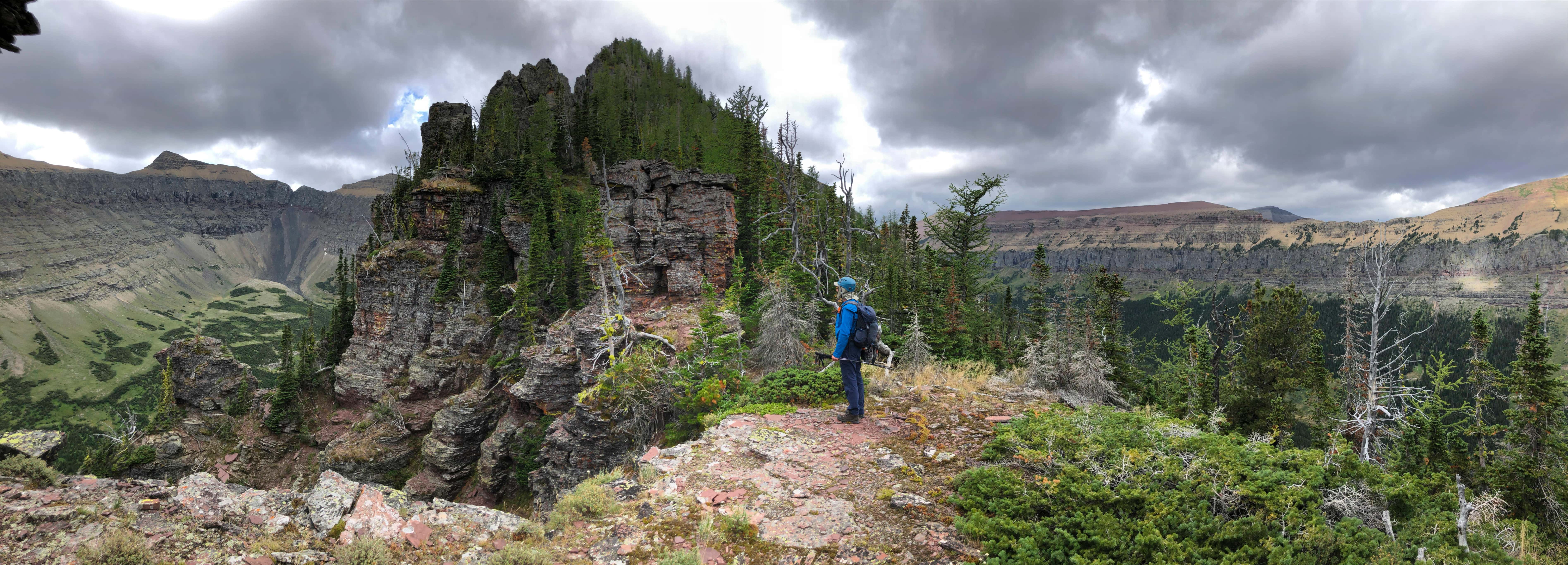
Sweet! This is a cool looking ridge!

Gazing up the neighbouring valley between “Newman Senior” and Mount Glendowan (left). Outside of sheep hunters, I’m sure it sees few visitors.

The first of many pinnacles to come. There was also a great game trail we could follow. (Photo by Andrew Nugara)

A pano of the previous photo highlighting the northeast ridge of Glendowan. (Photo by Andrew Nugara)

The same perspective again, this time highlighting Spionkop Ridge.

Enjoying the sun while it lasted. (Photo by Andrew Nugara)

Approaching the start of some cool terrain.

Andrew stands inside an impressive gap.

Scrambling onto the crest.

More of the same. We were hesitant to tackle everything just in case we were forced to backtrack. (Photo by Andrew Nugara)

Enjoying the ridge so far!

A closer look at the pinnacle from the previous photo. It was huge!

Some great craic! 😂

A pano of the previous pinnacle. (Photo by Andrew Nugara)

More super cool terrain!

I lead the way. (Photo by Andrew Nugara)

A super-duper sheep trail will take us right on through. (Photo by Andrew Nugara)

A wider look at the previous photo. (Photo by Andrew Nugara)

The ridge continues to impress.

Following the sheep trail.

Another series of pinnacles.

The pinnacle on the right kind of looks like Homer Simpson…

The trail led us quite far below the crest.

Looking across at the middle peak of Spionkop.

Following the trail…

Before deciding to head back onto the crest.

Spread Eagle Mountain on the far right.

Back on the crest.

The weather wasn’t clearing as forecast, but at this point, it was a pleasant temperature with a slight breeze. (Photo by Andrew Nugara)

Glancing back along the ridge.

From here on, the terrain softens. (Photo by Andrew Nugara)

Heading to the next high point.

We could now see Loaf Mountain (right) poking over Spionkop Ridge.

Getting a good look at Mount Glendowan (centre).

Another look at Loaf Mountain. (Photo by Andrew Nugara)

The view back to Spread Eagle Mountain and Mount Yarrow.

Gazing across the northeast ridge of Glendowan to the summit of “Cloudowan Peak”.

I look pretty determined. 😂 (Photo by Andrew Nugara)

The high point before “Newman Senior” comes into view, though we still couldn’t see “Newman Senior”. (Photo by Andrew Nugara)

Here is when it started to get gusty.

The sky was definitely not clearing as forecast. 🤔 (Photo by Andrew Nugara)

A good look into the Yarrow Creek valley and Newman Peak (left of centre). Our planned descent route was to come down the trail at the col (centre) between Newman and Spionkop (right). It would be a nice, easy way off the ridge – or so we had planned.

Many familiar friends make up the front range of Tatsiki-Miistáki (Castle). 😊

Approaching the high point.

Another look at Mount Glendowan.

The high point on the right with Glendowan on the left. In the background is Anderson Peak (centre).

A wider view of the previous photo. (Photo by Andrew Nugara)

We could still see the gas well and the road in.

Though it was tempting to bypass, it was a short, but worthwhile trip to the top of the high point.

Too bad it was cloudy because the amount of colour would be outstanding. (Photo by Andrew Nugara)

A slightly different version of the previous photo. (Photo by Andrew Nugara)

Rain had moved in to the north. That was quick!

A small cairn sits on top of the high point.

The connecting ridge to Mount Glendowan.

Gazing back along the northeast ridge. This was definitely a worthwhile endeavour. 😊

The object of our affection, “Newman Senior”. At 2640 m it’s 125 m higher than officially-named, Newman Peak.

Encountering strong wind as we enter the col. We could also see rain to the west and the north. Our planned descent route is in the centre. (Photo by Andrew Nugara)

A different angle of the previous photo, but this time showing Newman Peak (left). (Photo by Andrew Nugara)

My view back to Andrew.

From the col we could see sunshine on Piinaquiium / Ahkoinimahstakoo (Mount Blakiston). On the far right is Anderson Peak.

It was a 143 m elevation gain over ~540 m from the col to the summit of “Newman Senior”. (Photo by Andrew Nugara)

Looking back to the col.

The rain bands are getting closer and the wind is getting worse…

Looking over to Glendowan, “Cloudowan Peak”, and “Cloudy Junior”. (Photo by Andrew Nugara)

The sky begins to grow dark. (Photo by Andrew Nugara)

The summit of “Newman Senior” (2640 m). We didn’t even stop or slow down – we just kept on trucking.

Andrew is staggered by the wind.

This is basically the same photo as before – except this is 4 minutes later and rain is now falling over Glendowan.

We could also see rain coming from the southwest.

Anderson Peak is being soaked.

We had little choice but to head to the col with Newman Peak (right). At this point we were still dry but the wind was getting worse.

How quickly can we make it to the descent col (centre)? 🤔

Rain…

and more rain – but not yet on us.

Oh look! The sun is shining on Newman Peak. Maybe everything will blow over?

Sweet! The wind may be getting worse, but at least the rain over Newman has stopped.

Yikes. This is 2 minutes from the last photo and a wall of freezing water and ice pellets is just about to hit us. Did I mention that the wind was also insane and that the temperature dropped to near freezing? 😳

At the base of Newman and soaked to the bone. Even with gloves on, our hands were numb and we were both shivering. There was nothing to do, but try and escape to the valley below. Even if the rain stopped, the frigid wind would turn us into popsicles before we reached the col with Spionkop. We had to backtrack and look for a way off.

The summit of “Newman Senior” was now beclouded.

After backtracking a couple hundred metres, we saw a route down through the cliff bands below.

We would trend skier’s right to avoid the cliffs.

Getting closer to the valley floor.

At least it had stopped raining.

Looking down and along the Yarrow Creek valley.

The wet cliffs we avoided.

Back on easy terrain.

The headwaters of Yarrow Creek.

Gazing up at the col we were supposed to use.

On the trail that leads to the Newman / Spionkop col.

It was still windy, but we were thankful to be off the ridge.

Looking across to “Newman Senior”. It would’ve been very tricky to get through those cliffs in the rain.

At the tarn and looking towards Newman Peak.

A pano of “Newman Senior” and Newman Peak – and the cliffs we avoided.

Leaving the tarn to find shelter from the wind.

There were cow patties everywhere, so it took a bit to find a patch of ground where the cows didn’t also seek shelter.

A closer look at the tag on the log.

After a quick bite to eat and realizing that our packs – and everything inside – was soaked, we set off along the trail. The only equivalent that I can think of, would be if we had fallen into a river with all our gear on. That’s how wet we were.

Even the cows were sheltering.

The trail was good and the valley was scenic, so this boosted our spirits.

Looking back to Newman Peak.

Easy hiking – even in wet boots. 😊

More rain incoming – only this time, it would stick around.

Passing our ascent route onto the ridge.

Hiking in the rain.

Almost back at the gas well.

Taking cover from heavy rain. It didn’t let up, so we just kept going.

We made quick time along the road.

Back on the single track…

And now the cutline. It was all downhill from here.

Arriving at the end of the cutline with my truck off in the distance.

Andrew took this from the highway as we drove away, so it’s no wonder we were soaked. In reality, the rain wasn’t the main issue, it was all that came with the front that hit us: the insane wind; the plummeting temperature; the volume and velocity of the rain; and the ice pellets… ouch. All this happened in the span of ~10 to 15 minutes and there was little we could do. We were soaked and shivering. Thankfully, we were at a point on the ridge where we could find a quick way off. This will undoubtedly go down as a memorable mountain adventure.
Outside of the crazy weather, the route was interesting and enjoyable. The northeast ridge of “Newman Senior” was fun to explore and the Yarrow Creek valley was a great place to visit. Even the bushwhacking was tolerable – or should I say “bearable” thanks to the many paths left by our bruin friends. Finally, a HUGE thanks to Andrew for his willingness to keep exploring new routes on mountains he has already visited. 😁


Leave a Reply