
⚠️ Hiking and scrambling are inherently dangerous activities. Please read my Disclaimer. ⚠️
Without a doubt, experiencing sunrise on a mountain is a great way to start off the year. Watching those first rays light up a section of red argillite in a momentary blaze always draws me to wonder at the beauty of the world we live in. This grand spectacle only lasts a few minutes and if you miss it, you may never know what was. However, if you have seen it, you remember because it forced you to stop and stare for a few fleeting minutes before the light returned to normal. As I get older, this kind of pause becomes an increasingly important metaphor in my life. Indeed, when I think back over the past year, I’m floored at how fast life changes. Melanie and I are now grandparents with a second grandchild expected in the spring. Our oldest son was married in August; capping off three weddings in four years for all of our kids. Though we are financially poorer because of the weddings, we are far richer from welcoming new members into our family. With work only accelerating in busyness, enjoying time with family and getting out to the mountains on a regular basis will be even more important for me in the coming year. 😊
So, with a short window to work with, today’s trip was a repeat of “Yarrow Ridge” that I did back in October 2019 with Brad under extreme wind conditions. In fact, the wind was so bad on that trip, that we ended up crawling on our bellies along the ridge, before retreating off the mountain in search of shelter. Thankfully, today’s weather was the exact opposite – a beautiful winter day with little to no wind and a temperature of -2 C – perfect!
As Andrew had also done “Yarrow” a couple times before, we thought we’d try a new route because, well, we could – and that’s the beauty of living in southwestern Alberta. There are usually multiple routes up an objective and when you repeat, you aren’t prescribed to a particular track. In the case of “Yarrow”, this meant engaging in some exploratory scrambling up an inviting gully that neither of us had tried before.
Surrounded by sunlit argillite and interesting rock folds, the gully proved to be well-worth exploring, even though we were eventually forced to backtrack and re-ascend along the side. What could have been a simple New Year’s Day hike to the ridge, had turned into an opportunity for even more fun!
After reaching the ridge and enjoying the easy walk to its highest point, both Andrew and I were amazed that this was the first time either of us had been here when it wasn’t insanely windy. The fact we could stand upright, converse in normal voices, and linger to enjoy the view was remarkable for this locale and hopefully indicative of what the rest of our mountain experiences will be like in 2023. You can only hope, right…? 😁
Happy New Year everyone!

To get to “Yarrow Ridge” from Lethbridge, we drove west on Highway 3 to Pincher Creek. We then followed Highway 6 south for ~27 km until we came to the Twin Butte General Store. Here, we continued south on Highway 6 from the entrance of the store for another ~4.2 km until we come to the junction with Township Road 34. We turned right and onto Township Road 34 and drove west for ~8.2 km until we came to a T-intersection with Range Road 303. Here, we turned left and proceeded for another ~1.3 km until the road ended. This is the trailhead.
The field immediately to the west of Range Road 303 is private and is demarcated by an electric fence marked with numerous, ‘No Trespassing’ signs. The trail begins at the parking area and crosses through a deliberate opening where a fence leading to the east, intersects with the electric fence. We followed the trail alongside the electric fence for ~300m towards an obvious cutline. We soon arrived at a gate with a sign that says, ‘Please Close the Gate’ – though this time it was deliberately strapped open. We went through the gate and followed the cutline south until we came to very obvious open slopes that led directly to the north end of the mountain.
Once at the base, our route initially went up a short gully but after being cliffed-out, we retreated back to the base where we ascended along the cliffs above the gully. After gaining the ridge it was an ~880 m hike to reach the summit. We then descended via a drainage on the south side of the mountain before traversing back to our approach route and then back to the trailhead.

Our total roundtrip time was 4 hours and 30 minutes and our total distance travelled was 8.8 km. Total elevations gains came in a 700 m.

Gearing up at the trailhead for the first hike of 2023. 😁 It was a fantastic winter day with little to no wind and ideal temperatures. “Yarrow Ridge” is on the right.

Andrew leads the way as we start off.

The gate was already strapped open, so there was nothing to close.

Easy hiking along the trail. We will leave this section of the trail when we reach the high point in the distant centre.

Arriving on top of the high point. From here, we will use a secondary trail and open slopes to reach the base of the mountain.

It’s not big, but there are lots of options for ascent. At this point, we weren’t sure what way we’d choose.

A glimpse of what’s to come – walking past some red argillite as we near the base. (Photo by Andrew Nugara)

Sunrise on the first day of 2023. Happy New Year! 😊

The first rays of sunlight begin to draw colour out of the rock.

A closer look as the increasingly bright rock.

A ram (top centre) crosses the now blazing argillite. This kind of intensity only lasts a few minutes which is why it’s so cool to see.

After a bit of deliberation, we settled on attempting an ascent through the cliff band in front of us. This would be a new route for both of us.

A better look at the cliff band with the gully we will use, located just to the left of centre.

Entering the gully. It was steeper than it looks!

We could tell that we were going to be treated to some amazing rock. 😊 (Photo by Andrew Nugara)

Gazing back and across a mix of red and green argillite shortly after starting.

Following alongside the enormous cliff.

Andrew stops to admire the rock.

Continuing to make our way up. (Photo by Andrew Nugara)

Andrew scrambles up to inspect a fascinating series of folds.

I pause to check out the upper section of the gully. (Photo by Andrew Nugara)

A wider view of the same photo. There appeared to be no way around this without some seriously involved scrambling. (Photo by Andrew Nugara)

Andrew heads over to search for a route.

Up…

And up he goes.

However, he couldn’t find an easy way. This is his view from where he stopped and you can see how vertical the rock becomes. (Photo by Andrew Nugara)

Andrew at the point where we decided to backtrack in search of another route.

Heading down to the bottom of the gully. We decided to turn to skier’s left at the base of the gully and climb back up and onto the top of the cliffs. (Photo by Andrew Nugara)

Andrew stops for one more look at the folds.

Leaving the gully.

Following some convenient sheep tracks.

I take a brief detour to check out a potential scramble route.

Heading back onto the cliffs.

We came to a huge section of slabs that reminded us of Three Lakes Ridge…

So of course, we had to go and check things out! 😁 (Photo by Andrew Nugara)

The slabs were comprised of insanely cool rippled-marked and mud-cranked argillite.

Example #1…

Example #2…

Example #3…

And example #4. These rock murals really stand out under the low angle of the winter sun.

Example #5…

And example #6.

We continue to head upwards. (Photo by Andrew Nugara)

I climb a short but inviting section. (Photo by Andrew Nugara)

You’ve heard of ‘Elf on a Shelf’, well, I present to you, ‘Dave on a Shelf’. 😂

My view down to Andrew.

We were being watched… (Photo by Andrew Nugara)

This ewe was very curious about our presence.

I try and have a conversation with her. 😂 (Photo by Andrew Nugara)

Ahhh, this is why she was so interested in us! She had a calf with her. Right now she is saying to it, ‘See these middle-aged idiots? Whatever they do on a mountain, do the opposite.” 😂

Continuing to head up. (Photo by Andrew Nugara)

The ewe and her calf decide to move off, but they didn’t go too far away. Thanks for sharing your mountain with us Ms. Sheep and sorry for the disturbance!

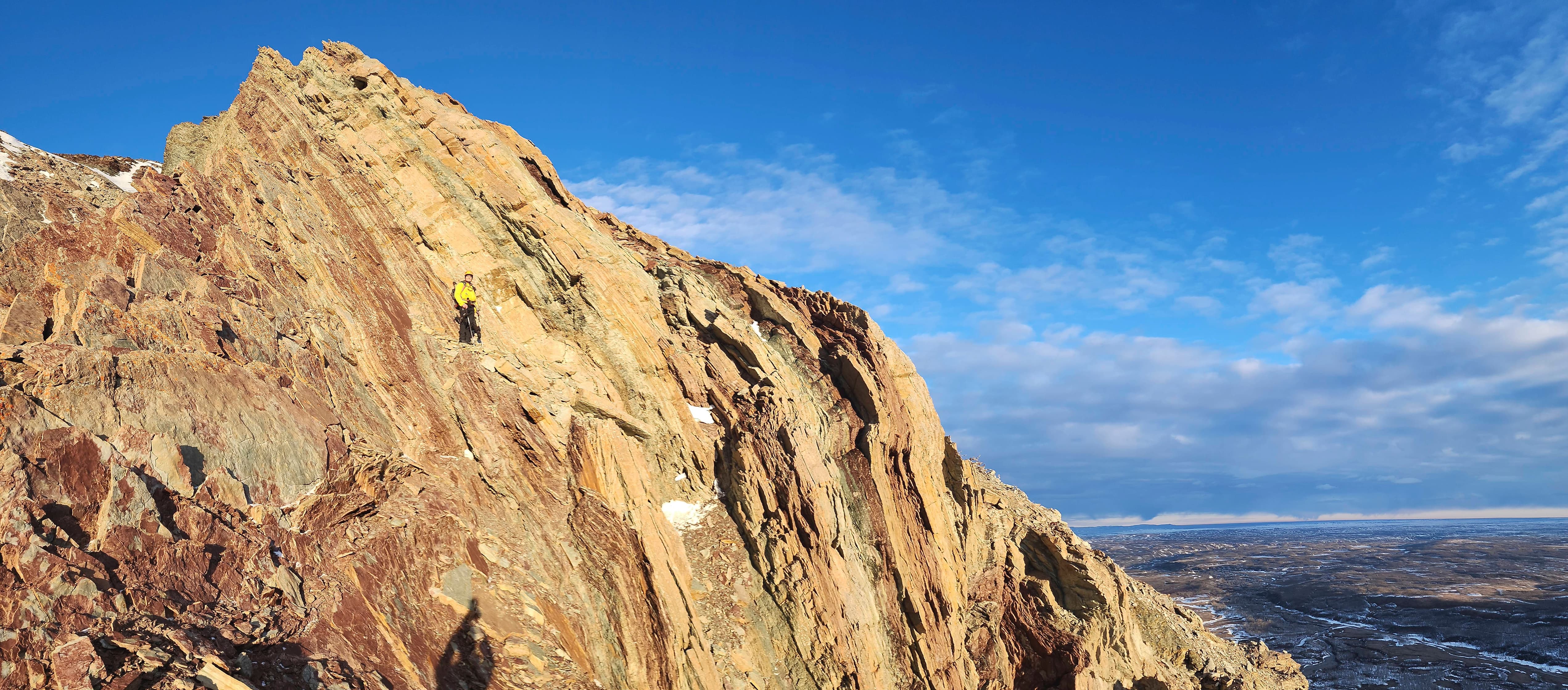
Andrew tackles a very narrow section of the ridge.

The northeast end of “Cloudowan Peak” looks frosty.

As does Cloudy Ridge.

A good look at “Cloudy Junior”.

Continuing along the cliffs above the gully.

Nearing the top of the ridge. (Photo by Andrew Nugara)

Andrew stops to admire a section of overhanging rock.

Making a short traverse to check out some orange lichen.

A good look at the lichen. There is lots of colour on this mountain!

Scrambling up…

And towards the ridge. (Photo by Andrew Nugara)

On the ridge crest. (Photo by Andrew Nugara)

Another view of the previous photo.

Andrew leads as we tackle the first high point.

The view from the top of the first high point towards Mount Yarrow (centre) and Spread Eagle Mountain. The second high point is in front of Mount Yarrow.

Heading to the col with the second high point. Back in 2019, this was where Brad and I bailed due to extreme wind.

Glancing back to the first high point.

Nearing the top. (Photo by Andrew Nugara)

Arriving on the summit of the second high point which is the unofficial summit of “Yarrow Ridge” (2128 m).

A pano to the south…

And then to the west.

A pano to the north…

And finally to the northeast. It was remarkable at how calm it was.

A close look at Spread Eagle Mountain.

Mount Yarrow towers above the ridge.

A cloud-covered Mount Glendowan.

The fun little summit of “Cloudowan Peak” is on the right with the lower northeast end in the centre.

Looking across to “Cloudy Junior” (centre) and Cloudy Ridge (right).

Gazing south towards Mount Dungarvan (right of centre) and “Rogan Peak” (left of centre).

Ninastako sits in the distant centre with Lakeview Ridge and “Kesler Lake Peak” in the foreground.

Kesler Lake is in the foreground with the north summit of Lakeview Ridge behind it. The long treed ridge in the distance is Mokowan Butte.

Andrew was just as shocked as I was, that we could stand around and chat without getting blown off the mountain. This was not the case on previous visits.

Me on the summit. (Photo by Andrew Nugara)

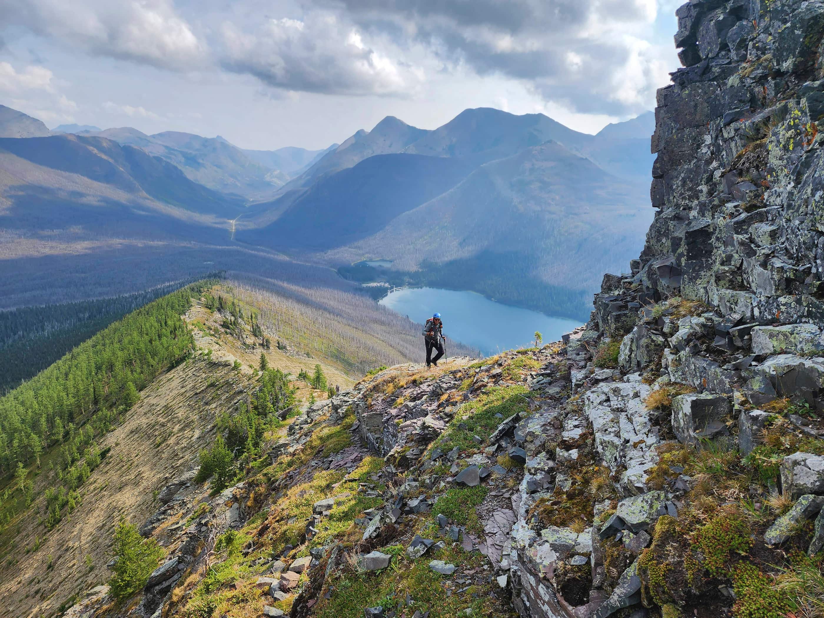
To descend, we opted to follow the south slopes to a snow-filled drainage.

Arriving at the drainage.

More cool rock.

Following the drainage.

Looking back to the second high point (centre).

The drainage narrows…

Before dropping off into an icefall.

Bypassing the icefall by heading to skier’s left.

This was much easier terrain to descend. (Photo by Andrew Nugara)

Yet another section of beautiful overhanging rock.

Andrew traverses across a vegetation-covered slope.

Nearing the bottom. (Photo by Andrew Nugara)

Instead of descending directly back and onto the trail, we traversed along the base of the mountain until we rejoined our approach route. This allowed us to avoid having to hike up two steep sections of trail. (Photo by Andrew Nugara)

Enjoying the easy traverse.

Back on our approach route with the gully and cliffs that we ascended directly behind Andrew.

The snow was not just hard-packed, it was super-packed.

Back on the upper trail. (Photo by Andrew Nugara)

It was easy-peasy from here.

Arriving back the the trailhead 4 hours and 30 minutes after starting. Spending a beautiful day on mountain with a great friend was a fantastic way to begin a new year. Thanks Andrew and Happy New Year everyone! 😊


Leave a Reply