
⚠️ Hiking and scrambling are inherently dangerous activities. Please read my Disclaimer. ⚠️
All credit to Sonny and Zosia for today’s objective and route. Until this weekend, I had never heard of Mokowan Butte and had always assumed that the large, treed ridge located on the far eastern boundary of Paahtómahksikimi (Waterton National Park) was Bird’s Eye Butte – an objective that sits entirely on private land. Therefore, when Sonny and Zosia invited me to join them for a hike up Mokowan, I was both confused and intrigued – which for me, isn’t an unfamiliar state of mind. 😂
Gracious in addressing my mistake, Sonny explained that Mokowan Butte sits partially inside the Park boundary and partially on a public grazing lease, with its highest point, squarely inside the lease. However, since we didn’t have permission to venture onto the leased land, our objective would be the gazetted Park summit that the late Rick Collier documented (we think 🤔) in 2010. Indeed, other than Rick’s handful of pictures on Flikr, there is little online information for Mokowan Butte. That Rick never bothered to post an actual trip report on Bivouac speaks to why this is not a well-known or frequented destination. It is just that obscure and uninteresting, especially when compared to the mountains that sit across from it. In fact, I have a strong suspicion that we may be among the few who have visited Mokowan in recent years.
That being said, I do relish in exploring these locations and I’m so glad that Sonny and Zosia do as well. It’s even better when someone like Sonny does all of the homework and maps out the route in advance! Thanks Sonny! 😁 Moreover, even though the summit itself is completely treed, the summit ridge does offer some good views to the south and to the west, in particular, Istiikoiistakoo (Sofa Mountain) which sits directly across the valley.
By sheer coincidence, I had the privilege to meet with Niina Piiksi (Mike Bruised Head) the day after our trip and I asked him what Mokowan means in Blackfoot. Mike is a Knowledge Keeper who is completing a PhD centred on recovering the original Siksikaitsitapi names for mountains. I was honoured to work with both him, and the amazing Lisa Kozleski, on a recent edition of Wider Horizons that focuses on the southern Alberta landscape and the corresponding Siksikaitsitapi names and stories.
Mike told me that Mokowan is Blackfoot for ‘stomach’ or ‘belly’ and the name stems from Mokowansiitahta or the Belly River. It refers to the ‘belly’ (headwater valley) of the mountains where the waters collect and flow outward. He noted that the first ‘o’ in Mokowan is long and that a more accurate spelling of it would be Mookowan (which sounds like Mow-ko-wan).
I doubt many hikers will be interested in Mokowan Butte, but for those who might be – and I can think of only 6 or 7 off the top of my head and of these, 3 were on this trip – it is, as Rick Collier notes, an official (or at least gazetted) summit. Personally, what made this into yet another fantastic day in the mountains, was the great company and conversations that I had with Sonny and Zosia. Thanks again to you both!
Be sure to read Sonny’s excellent trip report!

To get to Mokowan Butte, we drove ~16 km south on Highway 6 from its junction with Highway 5, until we crossed the bridge over the Belly River. Immediately on reaching the other side, we parked on the shoulder, making this our starting point.

From the bridge, we followed a marked trail north for ~530 m before leaving it to go off-trail in search of a small pond known as Giants Mirror. Once off-trail, we headed east for ~250 m and quickly arrived at the south end of Giants Mirror.
From Giants Mirror, we followed the undulating terrain eastward for ~2.5 km until we found ourselves below the bluff-like summit ridge. A steep, but quick hike of ~150 brought us onto the surprisingly open ridge, where we enjoyed the views before setting off in search of the summit. The entire open part of the ridge totalled approximately 420 m.
The gazetted summit is located ~500 m to the northeast from the last open section of ridge and is completely treed with no view whatsoever. In fact, outside of GPS, it is really a guess as to where the summit is, for there is no cairn nor is there any distinguishable landmark.
To return, we followed our route off the ridge before deciding to take a more direct line back to the highway in an attempt to avoid some of the ups and downs that we encountered on the way in. On the lower section of the mountain, we ended up following alongside a drainage that led us back to the highway approximately 300 m from Sonny’s car.

Our total distance travelled was 10.7 km with a total roundtrip time of 5 hours and 29 minutes. Total elevation gains came in at 460 m. Interestingly, at the end of the day, Sonny and I discovered that our GPS readings were quite different. For reference, Sonny logged the trip at 8.7 km with a 389 m elevation gain. I guess one of us worked harder on the hike! 😂 It may also be that my GPS adds a metre every time I talk… sigh… extrovert issues. 😂

Our starting point on the east side of the bridge over the Belly River. Mokowan Butte stretches across the background, with the Park summit located – but not visible – on the left.

We had beautiful weather with little to no wind for most of the day. In fact, it didn’t start to rain until we were back at the car – just the way I like it! 😁

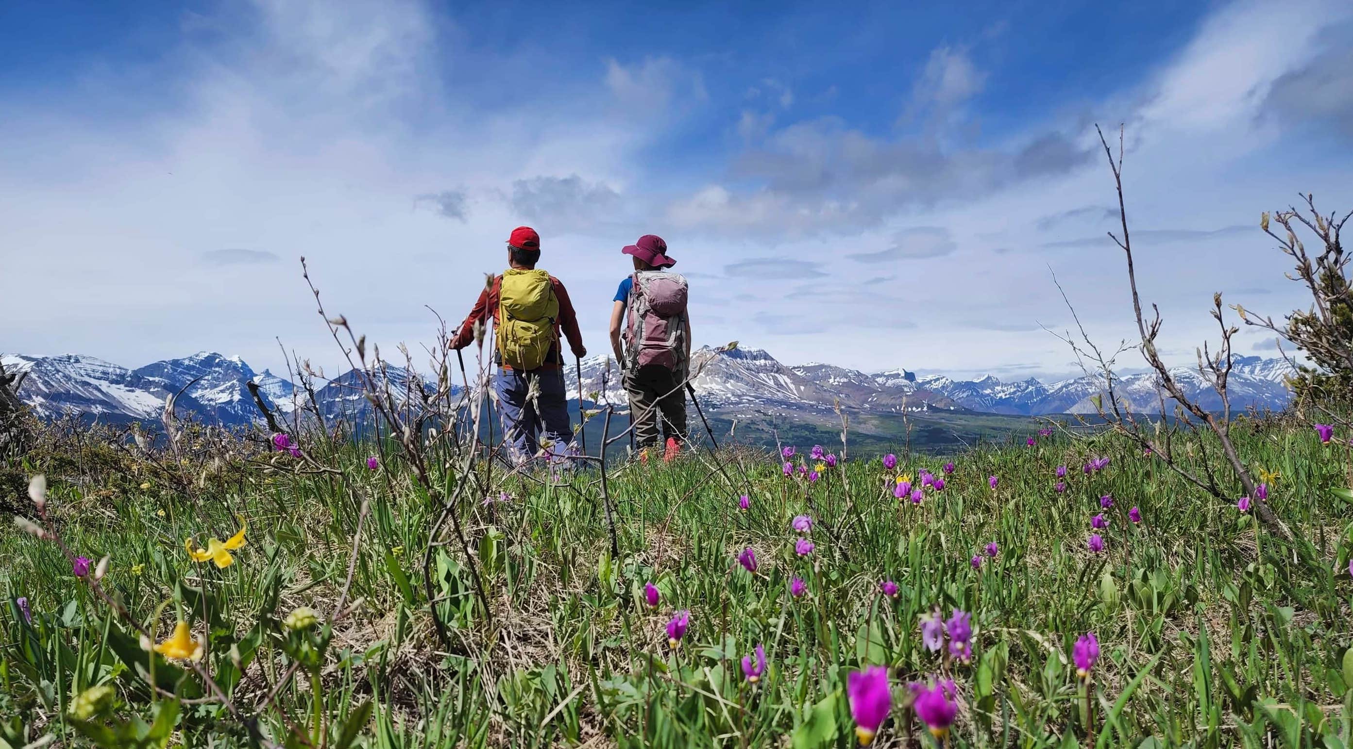
I have no idea where we’re going, but I’m glad Sonny does! (Photo by Zofia Zgolak)

The trail starts off by cutting through a small meadow.

Sonny and Zosia read a sign located along the trail.

Of all the days to not bring my gorilla suit! 😂

The trail follows alongside the Belly River…

Before narrowing as it enters the forest.

Approximately 530 m from the highway, the trail begins to descend. This is where we decided to leave it and head east, towards Giants Mirror.

Sonny leads the way.

After a quick ~250 m hike from the trail, we arrived at the south end of Giants Mirror.

Giants Mirror is a small pond that draws its name from its reflections. We didn’t walk the shoreline to see what it captured, but it’s possible the east side could reflect Istsiikooyiistakii (Sofa Mountain). 🤔

Leaving Giants Mirror.

A colourful shell that Zosia found in the woods near Giants Mirror. (Photo by Zofia Zgolak)

Much of the trip involved light bushwhacking over manageable, but ubiquitous amounts of deadfall.

Sonny expertly leads us through the forest.

At each opening in the canopy, we hoped to catch a glimpse of the summit ridge, but this proved impossible until we were standing directly in front of it.

Very cool insect tracks on deadfall – which is probably the reason why it’s now deadfall. (Photo by Zofia Zgolak)

Finally being rewarded with some views! In the centre is Istiikoiistakoo (Sofa Mountain).

The terrain on approach involved a series of small, undulating knolls that tricked us – well, me – into thinking we were heading up a much larger ridge. When we finally started onto an actual ridge, the grade was enjoyable.

The views now stretched to the south and included Ninastako (centre), the unique pinnacle Ninaki, and Yellow Mountain (right).

So… I ordered a clearance shirt from Eddie Bauer because I needed a new long-sleeved hiking shirt. The item description said the colour was ‘eggplant’ and I thought, how purple could it be? Apparently the answer is very purple! The trail cam folks will wonder why Grimace was wandering around the woods. 😂 (Photo by Zofia Zgolak)

More enjoyable hiking along the ridge.

We were now treated to views of Sarcee Mountain (right of centre), Kaina Mountain (centre), Sentinel Mountain (left of centre), Bear Mountain (left of centre), Mount Merritt (left) and Natoas Peak (left).

The man with the grand plan! Huge thanks to Sonny for doing the homework and route finding for Mokowan Butte! 👏

Passing beside a small pond.

It turns out that besides route finding, Sonny is also a butterfly whisperer. 😂 Zosia and I tried to get the butterfly to land on one of us, but it ignored us in favour of Sonny’s hat.

Sonny’s new friend.

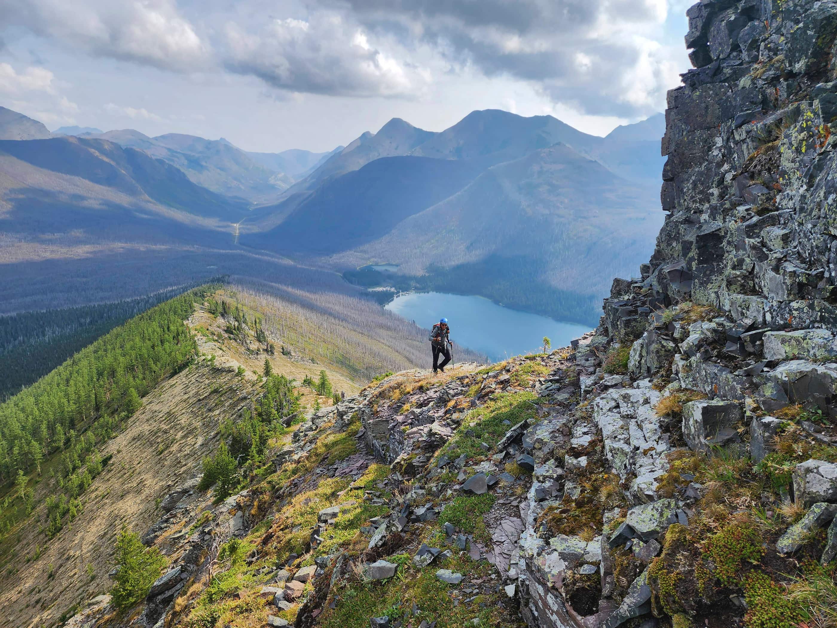
From our vantage in the previous photos, we could see that we were now beneath the summit ridge. From here, it was just a short, but steep hike to the top.

The view shortly after arriving on the summit ridge.

It was hard to not take a ton of photos of Istiikoiistakoo (Sofa Mountain).

Incoming weather on Kaina Mountain.

Same for Ptarmigan Wall (left) and Iceberg Peak (right of centre).

Settling in for the easy hike along the ridge.

We would hike until the ridge was no longer open (centre), before heading off into the trees to try and locate the actual summit. The entire open section of ridge was approximately 420 m long.

Taking advantage of a convenient game trail.

The ridge was adorned in wildflowers. Especially notable were the glacier lilies…

And the shooting stars.

The opening on the ridge extended quite far to the east and at times, resembled a large field.

The makings of an elaborate photo shoot. 😂 (Photo by Zofia Zgolak)

The finished product.

Zosia and Sonny enjoy the views from the same location as the previous photo.

A pano to the south from the highest open section of the ridge.

A pano to the west…

And then one to the north. We were surprised at how far we could see.

A closer look at Ninastako, Ninaki, and Yellow Mountain (right).

With the border now open, I’m looking forward to doing more exploring in Glacier National Park. For example, Gable Mountain would be an interesting trip. 😊

As would be Sentinel Mountain (left of centre) and Kaina Peak (right). If you look closely, you can see the summit of Niitaaspiitaa (Mount Cleveland) poking up from behind the summit of Kaina Peak.

I wish that my 2015 trip to Istiikoiistakoo (Sofa Mountain) had not been obscured by clouds and smoke. I may have to try it again on a sunny day. 😊 On the far right is Saakiihmabii (Vimy Peak).

Continuing to look west at Akiiohtaikiistakoo (Bertha Peak) (left), Buchanan Peak (left of centre), Buchanan Ridge (centre), and “The Senator” (right).

A slight adjustment to the last photo that includes Buchanan Northeast (right of centre) with Mount Lineham behind it.

Zeroing in on mighty Piinaquiium / Ahkoinimahstakoo (Mount Blakiston) with Mount Craandell in front of it. The low, treed ridge in the foreground centre is the Chief Mountain Highway Fire Lookout.

Continuing north along the front range of Paahtómahksikimi (Waterton National Park) with Mount Galwey on the far left, “Rogan Peak” in the centre, Mount Dungarvan on the right, and “Cloudy Junior” on the far right. In the foreground on the left is Bellevue Hill.

In the foreground is Bird’s Eye Butte, which for years, I mistakenly thought was Mokowan Ridge. Bird’s Eye is also an official summit, but it sits entirely on private land. Immediately behind Bird’s Eye Butte is Lakeview Ridge.

Moving further north to the front range of Tatsiki-Miistáki (Castle) and looking at Mount Yarrow (left of centre) and Spread Eagle Mountain (centre).

Still looking north, this time at delicious “Bakery Peak” (left) and Drywood Mountain (centre). The scrumptious “Croissant” and “The Muffin” are on the far right.

Finally, what more needs to be said about Prairie Bluff and its outliers: “Prairie Fire”, “Prairie Sky”, “Prairie Storm”, and of course, “Prairie Oyster”? 😁

Sonny and I on the last open section of ridge. (Photo by Zofia Zgolak)

As we set off in search of the summit, we came across this interesting, gnarly mess.

The reverse of the previous photo. It was cool that a young tree had grown up in the middle of all the old branches. (Photo by Zofia Zgolak)

Sonny guides us toward the general location of the summit.

The bushwhacking was decidedly worse than earlier in the day.

An old chainsaw mark was the only sign of human activity.

Sonny and Grimace discuss the location of the summit. (Photo by Zofia Zgolak)

Zeroing in on the general location…

Behold! The majestic summit of Mokowan Butte (1770 m)! 😂

As there was not much to look at, we headed back to the summit ridge where we enjoyed a nice lunch.

Gazing south along the ridge.

Pasqueflowers were ubiquitous along the ridge.

Time to leave.

Following the game trail down the slope. (Photo by Zofia Zgolak)

Nearing the base of the ridge.

Instead of following our approach route, we took a more direct line back to the highway so as to avoid the knolls.

Zosia has a keen eye for discovering dead things, especially bones and antlers. I walked right past this impressive 6 point elk antler without even noticing it, but thanks to Zosia, we were able to add a cool discovery to our trip.

For a size reference, my poles are set to 120 cm.

More interesting shells discovered by Zosia. (Photo by Zofia Zgolak)

Arriving back at the highway approximately 300 m from Sonny’s car.

This is definitely a scenic section of the highway.

Zosia with yet another dead thing. 💀

Arriving back at Sonny’s car 5 hours and 29 minutes after starting. This was a cool trip because I had no previous knowledge of Mokowan Butte before today, so I feel like I’ve explored something obscurely interesting. I doubt Mokowan sees many visitors, but its location near the headwaters of the Belly River is notable from an ecological standpoint. Again, a HUGE and MASSIVE thank you to Sonny and Zosia for not only doing all of the homework on Mokowan, but for the great conversations and companionship throughout the day. As I always say, being on a mountain makes for a great day, but sharing that experience with friends makes for a fantastic day. 😁


Leave a Reply