
⚠️ Hiking and scrambling are inherently dangerous activities. Please read my Disclaimer. ⚠️
Taking advantage of a windless but cloudy forecast, Andrew and I headed to the Crowsnest Pass to try our luck at snowshoeing up Trail Hill (1783 m). Located at the south end of Loop Ridge, Trail Hill is little more than a bump that blends into the landscape and for reasons that I’ve yet to discover, it is classified as an official summit. 😳 Why? My best guess is that it was used as a triangulation or phototopographic station during the Interprovincial Boundary Survey of the Crowsnest Pass during the summer of 1914; though it is lacking the telltale, well-constructed cairn. It may also have something to do with mining or forestry in the area. That an old resource road leads to the top, may be why it is called Trail Hill. If someone knows the answer, please let me know.
I first took note of Trail Hill during my snowshoe ascent of nearby Island Ridge in January 2016 and followed this up by reading Rick Collier’s, An Enchainment of Loop Ridge and Trail Hill. I’d always meant to return and try it, but it was so low on my priority list, that I’d actually forgotten about it until Andrew and I were discussing snowshoe options and it popped back into my head. As it would be a new objective for both of us – and that staying low on a cloudy day made more sense – it was an easy decision to make.
Prior to starting, Andrew found a trip report on AllTrails that took a slightly different path to the top than I had originally envisioned. My route would have followed a trail to the base of the southeast slope before leaving it to slog directly to the top. The AllTrails route was far more civilized and though longer, it followed an old road to the backside of the mountain and then up to the summit. However, what really cemented our choice of route, was the discovery that a solo snowshoer had recently ascended Trail Hill using the AllTrails route and most importantly, had broken trail for us through the deep snow. 😀 A HUMUNGOUS THANK YOU goes out to whoever this was!! We definitely owe you a beer!
Though tiny, Trail Hill does offer some decent views due to its open summit. As a snowshoe, it is good little destination that doesn’t take too much time, especially if snow conditions on Coal Road allow you to drive directly to the trailhead. We ended up parking at the Ptolemy Creek trailhead just to be safe, but in hindsight we could’ve driven the extra kilometre to the actual trailhead; though the hike along the road was easy.
Thanks again to Andrew for yet another great trip. 😊 Be sure to read his excellent trip report! [link coming].

To get to Trail Hill, we followed Highway 3 past Coleman towards the BC border. After driving 1.3 km beyond the rest area at the far west end of Crowsnest Lake, we turned left onto Coal Road. From here we drove ~3.2 km to our parking spot at the Ptolemy Creek / Valley of the Seven Bridges trailhead. The actual trailhead begins another ~1 km down the road, so drive it if you can.
There are a myriad of trails and old roads all around Trail Head, and the trick is finding the right ones to follow. From the trailhead we hiked for ~300 m until we came to a fork. Here, we turned left and followed the trail for another ~700 m until we came to a second fork. We kept to the right and followed the trail for another ~700 m until we came to a third junction. Here, we continued straight ahead and followed the trail for another ~100 m until we came to a fourth junction. Continuing straight, we hiked for another ~390 m until we came to a fifth junction, where we again continued straight. After another ~500 m of hiking, we emerged onto an open section of trail with a clear view of Trail Hill on our right.
As the snowshoe tracks we were following left the trail at this point, we correctly deduced that they were headed up Trail Hill, and since this person had done all of the hard work, we followed them. 😊 After leaving the trail, the tracks led west through the woods for ~250 m until it came to a trail. Instead of following it, the tracks continued across it and back into the trees in a westerly direction for another ~270 m until they arrived at the bend of a larger trail. From here we followed the trail and tracks for ~960 m until we were directly beneath the summit. A quick hike up open slopes brought us onto the summit. After enjoying the views, we returned the same way.

Our total distance travelled was 11.2 km with total elevation gains of 417 m. Our total roundtrip time was 3.5 hours.

Gearing up at the Ptolemy Creek trailhead. Though this is not the actual trailhead, we chose to play it safe and park here in case the road conditions deteriorated. From here, we will make the easy ~1 km hike along the road to the trailhead.

Trail Hill can be seen in the distance on the left as we cross a bridge along the road.

A closer look at Trail Hill.

Arriving at the trailhead which is ~1 km from the Ptolemy Creek trailhead. In hindsight, we could’ve driven the remainder of the road up to this point – oh, well. The trail starts on the right.

Starting down the trail.

Fortunately, we didn’t fall victim to a trap! 😂

Easy travel along a snowmobile track.

It was cloudy with a comfortable temperature of -7 C. (Photo by Andrew Nugara)

Coming to the first of 5 separate junctions. We will keep left and follow the tracks of a solo snowshoer.

Following the trail from the first junction.

It was a very peaceful trip.

Arriving at the second junction approximately 700 m from the first junction.

We kept to the right at the second junction. (Photo by Andrew Nugara)

My view back to Andrew from the previous photo. This is where we began to sing the praises of the person who broke trail.

A good view of “Mummy Mountain” and “Anubis Peak” on the Northwest Ridge of Ptolemy.

Approximately 700 m from the second junction, we came to a third. Here, we would continue straight ahead.

A short ~100 m walk later, we came to a fourth junction. Following the lead of the solo snowshoer, we continued straight.

Approximately ~390 m from the fourth junction, we came to a fifth junction. We again kept going straight.

Still enjoying our trip along the trail.

As we were following the solo snowshoer tracks, we began to speculate that they were headed up Trail Hill. It turned out that we were right! Approximately ~500 m from the fifth junction, we finally got a good look at Trail Hill (centre). This is the point where the snowshoer left the trail to head west – and so we followed their tracks. 😊

A broader view of the previous photo.

Andrew follows the tracks into the trees.

Andrew’s view back to me and the spot where we left the trail. (Photo by Andrew Nugara)

Following the tracks up and onto a narrow trail.

The tracks crossed the trail and continued into the woods.

The solo snowshoer made things so easy for us! A HUGE thank you to whoever you are! 😀👏👏

Approximately 520 m after leaving the trail, the tracks led us onto an old road / trail. From here we will follow the trail (and the tracks) for ~960 until we were just beneath the summit. By this point, we realized that the snowshoer was following the AllTrails route.

The views open up as we get higher.

Looking across the valley.

A closer look at the Northwest Ridge of Ptolemy (centre) and Mount Ptolemy (right).

It’s all fun and games when someone else has broken trail! 😀 (Photo by Andrew Nugara)

The summit had some impressive cornices.

Though the trail narrowed in places, it always remained obvious.

A closer look at Mount Ptolemy (left) and our ascent route along the southwest ridge. This trip was a highlight for me in 2022. 😀

Continuing along the trail to the backside of Trail Hill.

The summit isn’t far from here.

Arriving beneath the summit.

Andrew pauses to check out Mount Taylor (right) as we climb open slopes to the summit.

Looking back at Andrew with the south end of Loop Ridge in the background.

The summit of Trail Hill (1783 m).

A pano to the northeast… (Photo by Andrew Nugara)

And then one to the east. (Photo by Andrew Nugara)

A shorter pano to the northeast…

Then to the east.

A frosty Mount Ptolemy.

Another look at the Northwest Ridge of Ptolemy. This remains one of my favourite ridge walks in the Pass.

Getting a good look at Chinook Peak (right)…

Followed by an equally good view of Sentry Mountain.

Island Ridge is also a fun snowshoe.

Gazing across to Phillipps Peak (left), Mount Tecumseh (centre), and Omahkai’stoo (Crowsnest Mountain) (right). Crowsnest Ridge is middle distance and you can see the radio tower on its summit (far right).

“Alexander Creek Mountain” was a fun little solo trip.

A look at the myriad of roads and trails that make up the surrounding area.

Andrew on the summit.

After snapping some photos, we decided to head over to the southeast end of the summit. (Photo by Andrew Nugara)

My view of Tent Mountain from the previous photo.

Gazing across to Michel Head (left of centre). Resource company land restrictions have prevented me from attempting this peak, but I’m hoping that these will be lifted at some point in the near future once the logging has been completed. Edit: Done!

A pano of the southeast end of the summit.

Andrew’s view towards me… (Photo by Andrew Nugara)

And my view back to him.

Mount Darrah (centre) is high on my list.

Another look at Tent Mountain.

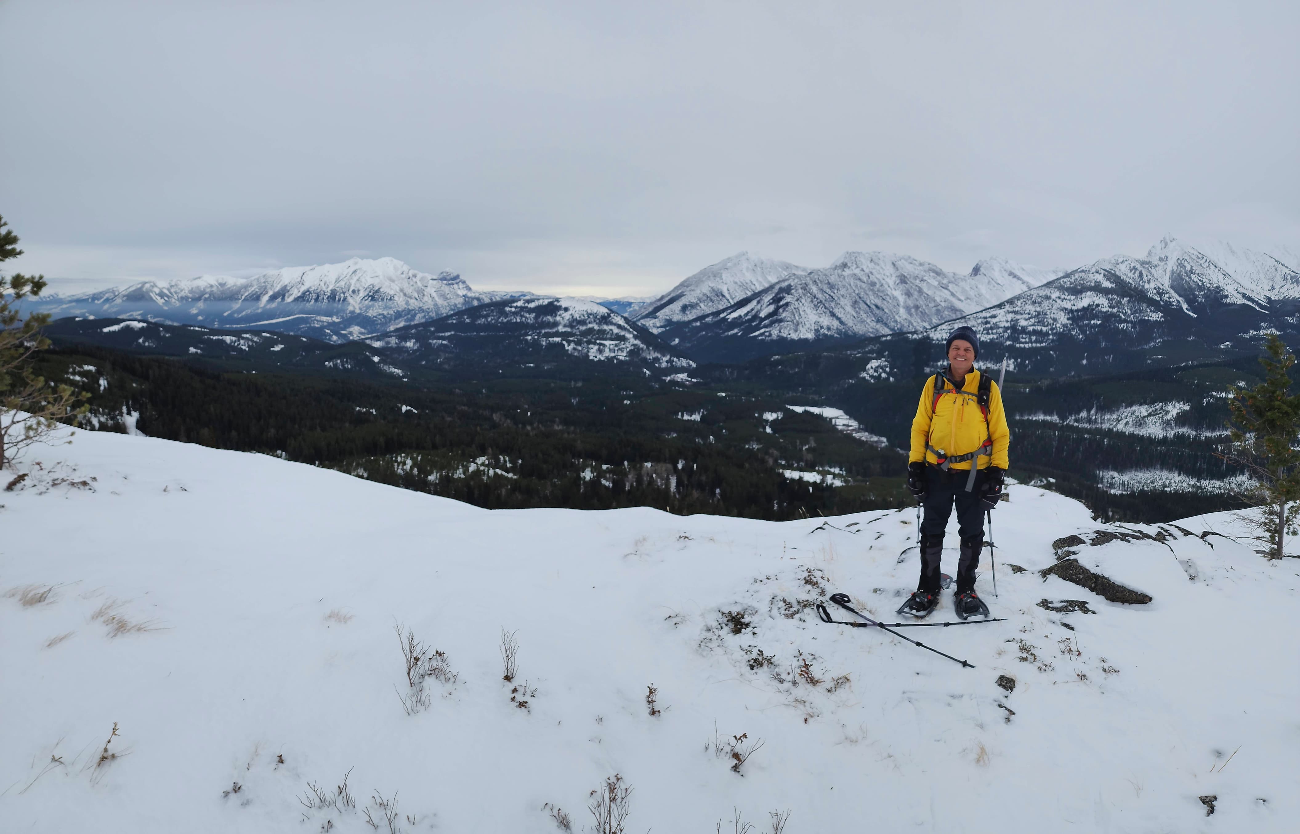
Me on the summit. (Photo by Andrew Nugara)

One last look before heading back.

A small cairn sits beneath the snow.

Gazing towards one of the high points on Loop Ridge.

Heading back to the trail.

On the trail and enjoying the quick trip back.

Looking across to Chinook Peak (left of centre) and the Northwest Ridge of Ptolemy (right).

A brief glimpse of the summit.

Arriving back where we joined the summit trail. We contemplated following it back to the main trail, but decided against it.

Heading back through the trees.

One last look back.

On the main trail and making great time.

Almost back at the trailhead.

Hiking back from the trailhead along the road. Island Ridge is in front of Andrew.

Arriving back at my truck 3 hours and 30 minutes after starting. Again, a HUGE and MASSIVE THANK YOU to whoever it was that broke trail all the way to the summit. This saved us a ton of work and route finding. You rock and we owe you a beer! 😀 Though Trail Hill is little more than a bump, it is still an official summit and one that neither of us had done before. Doing this as a straightforward snowshoe objective was the perfect choice for today.


Leave a Reply