
⚠️ Hiking and scrambling are inherently dangerous activities. Please read my Disclaimer. ⚠️
Well, it’s a new year and with it, another pandemic-altered celebration. Hopefully, 2022 will see SARS-COV2 wane in severity and by this time next year, we will all be saying, “Remember when we couldn’t gather as friends and family?” Fingers crossed… 😊
I have to say, making my fifth ascent of Prairie Bluff was not my plan to kick off 2022. With two weeks holiday over Christmas and New Year’s, I had hoped to get at least 3 or 4 trips under my belt; however, beginning on Christmas Day, an intense mass of arctic air settled over the region, keeping temperatures well below -25 C until today.
Last weekend, I tried to get up Mount Crandell with the Nugara brothers, but my worn winter boots couldn’t handle the wind chill and while Andrew and Mark continued on to the summit, I turned around and went home to do some online shopping for new boots. 😁 With a break from the frigid temperatures forecast for today, I set about trying to figure out where I should go – as I was pretty desperate to get out, even if it was just for the exercise. Of course, the trade-off for warmer temperatures in southern Alberta is the wind, and once again, it would dictate my choice of objective.
After considering several options along the front range, I settled on Prairie Bluff simply because it offered elevation beyond that of a foothill and a modicum of shelter from the wind. Though this was my fifth time up, I chose a route along the north ridge, something that I’ve used twice before. My strategy was to avoid the wind by staying on the east side of the crest and then once on the summit ridge, endure the wind’s wrath as I walked the remaining distance to the top.
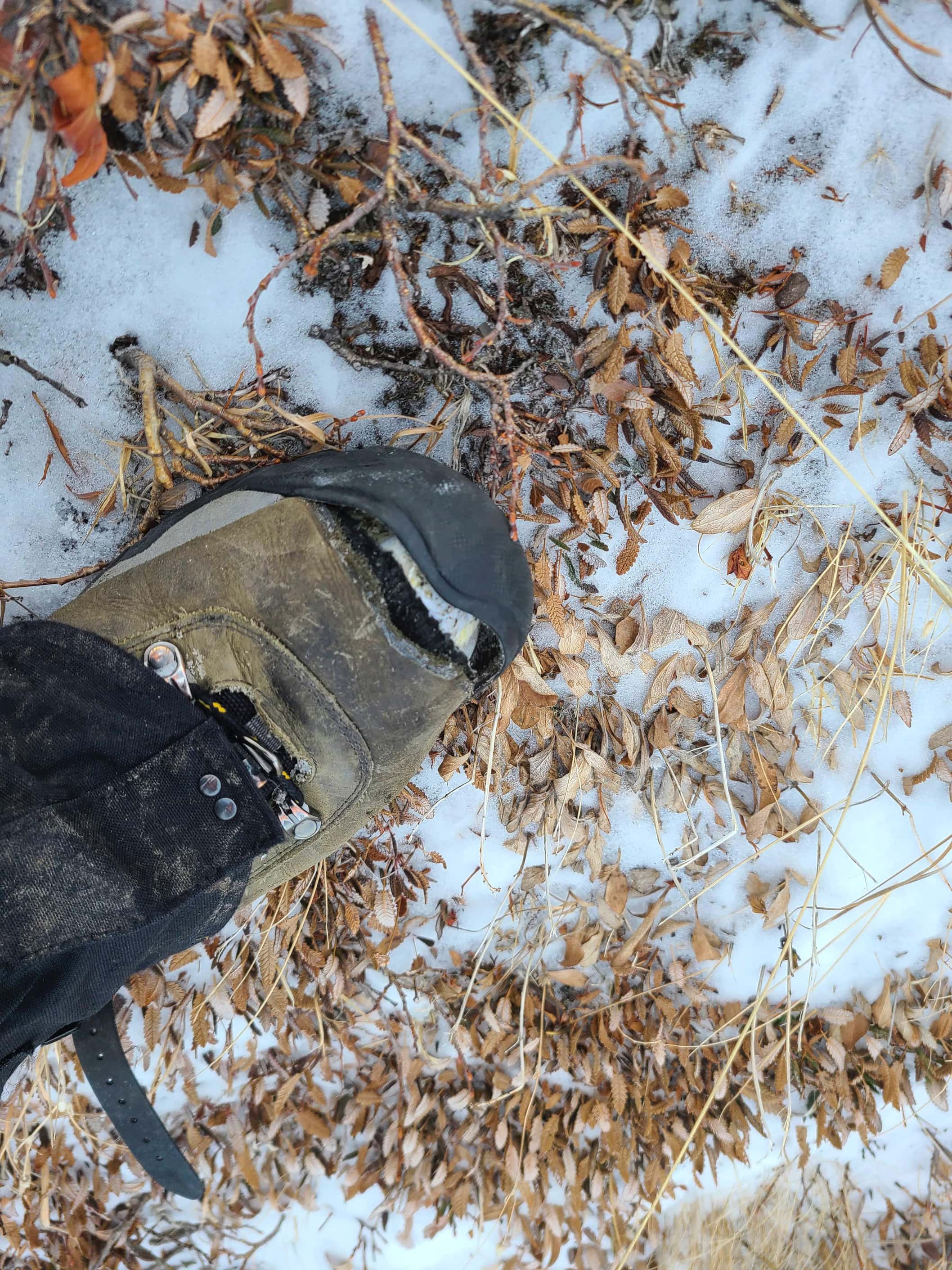
This strategy worked okay, though the wind was so intense, that even below the crest I was continually staggered. In fact, I was flat-out knocked to the ground at least seven times during the day. This was a huge reason why I avoided any scrambling, because the wind was akin to ‘Death’ in the movie, Final Destination, where an invisible hand was relentlessly trying to push me off the mountain. Fun times! 😉 The only other annoyance was that I tore the toe cap almost completely off my boot just below the summit, which made for some chilly toes while snowshoeing back to my truck. Fortunately, these were my old boots and not the ones I had ordered the week before.
Anyways, as I’ve already documented this route twice before, I will keep this post relatively short and sweet. Happy New Year and many happy trails for 2022! 😁

To get to Prairie Bluff from Lethbridge, I followed Highway 507 west of Pincher Creek to the Gladstone Valley Road which is located on the left side of the highway, ~1.4 km past the bridge over Mill Creek. After turning onto the road, I kept left at all major junctions, and until I eventually crossed two bridges over Mill Creek. Approximately 16.3 km from Hwy 507 or ~3.5 km from the 2nd bridge, I came to a junction where a closed red gate prevented me from continuing straight ahead. I continued on by taking the hairpin curve to the left and following the road as it climbed upwards for another ~3.3km until I came to a side road on my right. This road leads to a gas well at the base of Prairie Bluff and is where I turned onto. My parking spot for the north ridge route was large patch of gravel immediately across the gas road near to the junction with the main road.
From here, my route was obvious. I climbed the small embankment above the parking area and walked across an open meadow until I came to a creek. I crossed the creek (it was filled with snow) and followed it until I reached the point where it enters the trees where I then followed a slope on my left that led upwards. This is the beginning of the ridge, and I snowshoed through light forest for ~300m until I was above treeline and at the base of the ascent slope. A short, but steep hike of another ~300m brought me to the base of the first and largest band of argillite. As I’d already scrambled this twice before and because I wanted to stay out if the wind, I followed the band to climber’s left, gaining elevation as I went.
Eventually, I emerged onto a small shoulder, but quickly decided to remain below it due to the wind. I then followed beneath the remainder of the north ridge and then stayed below the summit ridge as long as I could – again to keep out of the wind. Once on the summit ridge, it was an easy – but windy – walk to the summit. I returned the same way.

This route allows for a quick trip. It took me 1 hour and 45 minutes to reach the summit with a total roundtrip time of 2 hours and 49 minutes. Total elevation gains were 533 m and my total distance was 5.4 km.

My starting point with the north ridge in the centre and the summit on the left.

My view as I cross the meadow next to the parking lot. This would be the third time I’ve used this route.

I’m glad I brought snowshoes!

Arriving at treeline with the first band of argillite above me. The slope to reach it is steeper than it looks!

Looking back from the base of the rock band. My parking spot is the open patch in the centre.

The scrambling on the north ridge is short, but fun. However, this time I would simply follow the base to climber’s left to avoid the wind.

The summit isn’t too far from here.

Arriving on the small shoulder where the wind forced me to remain below the crest.

Looking back to the shoulder.

A telephoto of the Livingstone Range.

Staying beneath the summit ridge as I close in on the top.

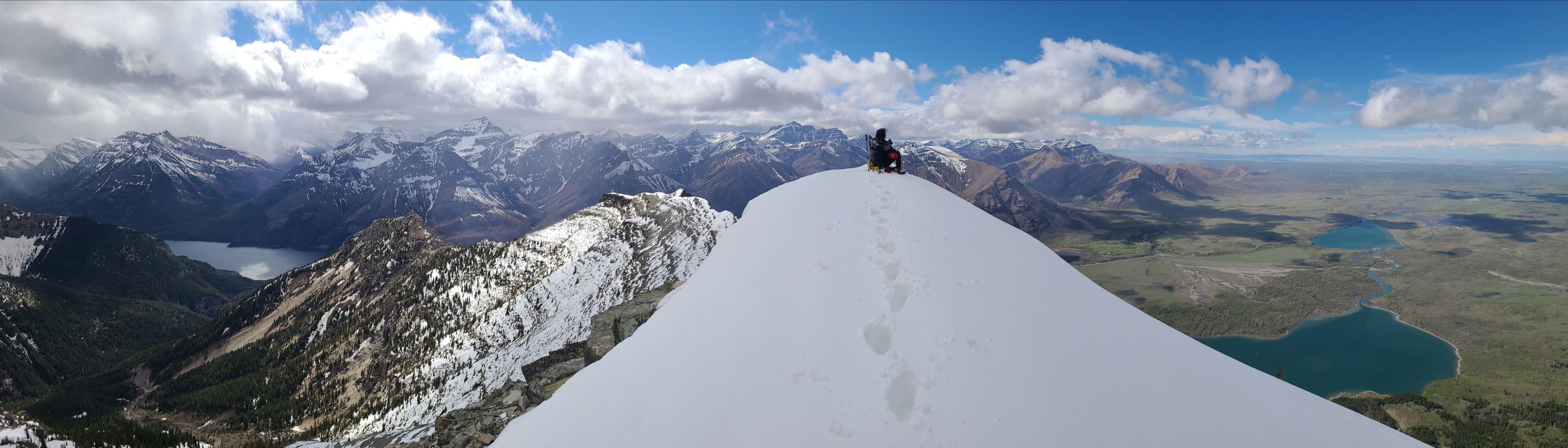
Finally on the summit ridge and being blasted by the wind.

A quick glance over to Victoria Peak (centre).

It was an easy walk from here.

Closing in on the summit…

My fifth time on the summit of PB (2285 m). In the foreground on the left is Christie Mine Ridge which sits entirely on private land. I was given permission to ascend it in the spring of 2021; however, I’ve never posted a trip report.

Looking to the southeast at Drywood Mountain (right of centre) and Pincher Ridge (right). “Prairie Fire” is in the foreground on the far right, while distinctive, Ninastako, sits on the horizon to the left of centre.

The view to the south. In the foreground centre is “Prairie Fire”, with the Centre Peak of Pincher Ridge to its right.

Of course, Victoria Peak (centre) always steals the show.

Gazing a little more to the west with “Mill Creek Mountain”, “Mill Creek Peak”, and Mount Gladstone in the centre.

Continuing the view to the west with Table Mountain in the centre.

The view to the northwest…

And finally to the north. In the foreground are Mount Baldy and Mount Albert which are located in Beauvais Lake Provincial Park.

Another look at Victoria Peak.

So much fun in one picture! In the foreground centre is “Whitney Ridge” with “Mill Creek Peak” and “Mill Creek Mountain” behind it on the left. In the distant centre is North Castle with Mount Gladstone to its right.

More fun with “Whitney Creek Mountain” in the foreground and “Gladstone’s Toe” behind it. In the distant centre is Table Mountain with “Table Top” on the far left. Diminutive “Beaver Mines Ridge” is on the far right.

Well this sucks! Shortly after leaving the summit I tore the toe cap on my boot. Good thing I have new winter boots on the way.

It was a quick trip back…

Though the gaping hole in my boot made snowshoeing a chilly affair. 😂

Another look back as I cross the meadow.

Arriving back at my truck after a quick 2 hours and 49 minutes. Though I’d love to have started 2022 by climbing something new, I’m not going to begrudge the opportunity to finally get out after the bitter arctic weather we’ve had. Hopefully in the coming weeks, the wind will die down enough to allow me to explore some new territory – though I’ve been saying that since the middle of November… 😳 Happy New Year!


Leave a Reply