
⚠️ Hiking and scrambling are inherently dangerous activities. Please read my Disclaimer. ⚠️
Happy New Year! A busy schedule combined with several weeks of -25c temperatures, meant that today was my first trip to the mountains since November – too long if you ask me! Joining me once again was my friend, Brad Wolcott, who shares my passion for exploring the many small ridges, hills, and mountains in the Castle and Crowsnest Pass.
Our objective was originally a series of high points on the far north end of Mount Gladstone that for some reason or another, I’ve taken to calling “Gladstone’s Toe”. However, we missed the turnoff to the starting point, and instead, decided to tackle a similar-sized mountain located directly to the east of “Gladstone’s Toe”, at the far end of Victoria Peak’s northwest ridge.
For all intents and purposes, this little peak is pretty much its own entity, as it sits isolated from all other features along the ridge. Indeed, it’s as if the ridge was supposed to end, but as it began dipping towards the prairie, it suddenly changed its mind and made one final push back towards the sky, resulting in a peak that offers wonderful panoramic views.
As far as I know, this mountain is unnamed, though I’m sure the local ranchers have a nickname. Throughout the day, Brad and I debated several of our own nicknames. Initially, we thought maybe we should keep with the theme of Queen Victoria and her family, since Mount Albert is located a short distance away in Beauvais Lake Provincial Park. Hence, we pondered calling it, “Mount Edward” after Edward VII, but perhaps the last thing we need are more mountains named after royals. We then toyed with the very cheeky, “Victoria’s Secret”, which played upon its location at the end of Victoria Peak’s northwest ridge and its surprising summit views – and this even got some air time for a few hours – but ultimately, I decided upon, “Whitney Creek Mountain”, after the creek located immediately to the east. It may be boring, but it will keep the lawyers at bay. 😉

To get to “Whitney Creek Mountain” from Lethbridge, follow Highway 507 west of Pincher Creek to the Gladstone Valley Road which is located on the left side of the highway, ~1.4 km past the bridge over Mill Creek. After turning onto the road, keep left at all major junctions, and you will eventually cross two bridges over Mill Creek. Approximately ~15.1 km from Hwy 507 or ~2.3 km from the 2nd bridge, you will come to a junction marked by a pipeline pumping station on your right. “Whitney Creek Mountain” is immediately behind the station, so turn here and follow the main road for 1.5 km until you come to a gas well at the base of the mountain. This is where road ends and it’s also where we parked – well away from any of the buildings.
From here there are a few options. We chose to take the most direct line to the summit, which ended up being ~1.1 km up the east face from my 4Runner, but it was quite steep and may not be everyone’s cup of tea for a snowshoe. Another option could be to bushwhack south along the base of the mountain for ~1 km until you come to the start of the southeast ridge that leads all the way to the summit. However, we rejected this idea because we weren’t sure how much deadfall we’d have to overcome and the fact that the snow was knee-deep. A third, and perhaps better option, would be to not turn off at the pumping station, but continue following the road for another ~2.4 km as it curves south around the mountain. You could then park your car and follow a drainage to reach the base of the southeast ridge. This might be less steep than our route, and if you try it, let me know!

Our route up the east face is what I call a ‘park and hike’, meaning that you literally get out of your car and start up the mountain. It was somewhat steep and when combined with deep snow, it took us just over 1.5 hours to ascend ~225 m to reach the top of the cliffs that we could see from my 4Runner – a distance of only ~653 m! Afterwards, the grade lessened for a bit, until just before the southeast ridge, where we had to climb over a cornice to reach the crest. From here it was an easy walk to the summit.
Though we returned the same way, we did consider following the southeast ridge all the way to the drainage to see if this would be an easier route. However, the thought of potentially having to break fresh tracks through knee-deep snow (and possibly deadfall) in the drainage, and adding an extra kilometre onto the trip, was nixed in favour of taking advantage of the trail we had already broken. Again, if you try this as an alternate route, let me know!

My GPS pinged the summit at 1942 m, though in comparing it with the topo map, it doesn’t look like the summit is more than 1919 m high.

As I mentioned, we took the most direct, but perhaps the steepest route to the summit. Our total distance travelled was 2.2 km with total elevation gains of 356 m. Our total roundtrip time was 3 hours and 27 minutes.

“Whitney Creek Mountain” (centre) from the Gladstone Valley Road. Our route went up the slopes on the left.

Looking towards “Whitney Creek Mountain” from our parking spot at the gas well. Even though it wasn’t far away, it took us 1.5 hours to reach the top of the cliffs in the background. The summit itself is not visible.

Another shot of our parking spot with Victoria Peak in the background. There are no signs indicating that parking or accessing the mountain from this location is prohibited. After turning around, we made sure to park far away from any of the buildings so that we wouldn’t be in the way.

Brad starts off towards the mountain.

We had to bushwhack through a short section of young pine trees to reach the ascent slope.

Once past the pine trees, our route opened up.

Though we took turns breaking trail, Brad willingly bore the brunt of the steepest sections. The moral of the story: always go snowshoeing with someone younger than yourself! 😉

The lower section of the mountain involved navigating through deadfall. (Photo by Brad Wolcott)

Slogging our way up the steep slope. (Photo by Brad Wolcott)

Again, hats off to Brad who forged most of the trail!

Looking northeast towards Beauvais Lake Provincial Park and Mount Baldy, Mount Albert, and Piney Point.

Arriving at the base of the cliffs. We easily bypassed them by keeping to climber’s right.

A fine view of Prairie Bluff from the edge of the cliffs.

Brad stops to enjoy the view from above the cliffs.

Looking east at Christie Mine Ridge, which sits entirely on private land.

Pincher Ridge (left) and Victoria Peak (centre).

Scrambling over a small section of rock. (Photo by Brad Wolcott)

Brad pulls himself over the same section of rock. On the way down, we easily avoided this obstacle by keeping to skier’s right.

Above the cliffs, the grade eased for a bit… which is why I took the lead! 😉 (Photo by Brad Wolcott)

However, the slope steepened significantly beneath the crest of the southeast ridge. At this point we decided to trend to climber’s left to find an easier access point.

The day before, the temperature hovered around -25c, but overnight it rose to -4c. I was perfectly comfortable wearing a base layer, a wind shell, and light hiking gloves. (Photo by Brad Wolcott)

Brad begins to make the short climb up the cornice and onto the ridge.

Brad’s the Bruce Lee of kick-stepping! 😉

A cool silhouette of Brad as he stands on top of the cornice.

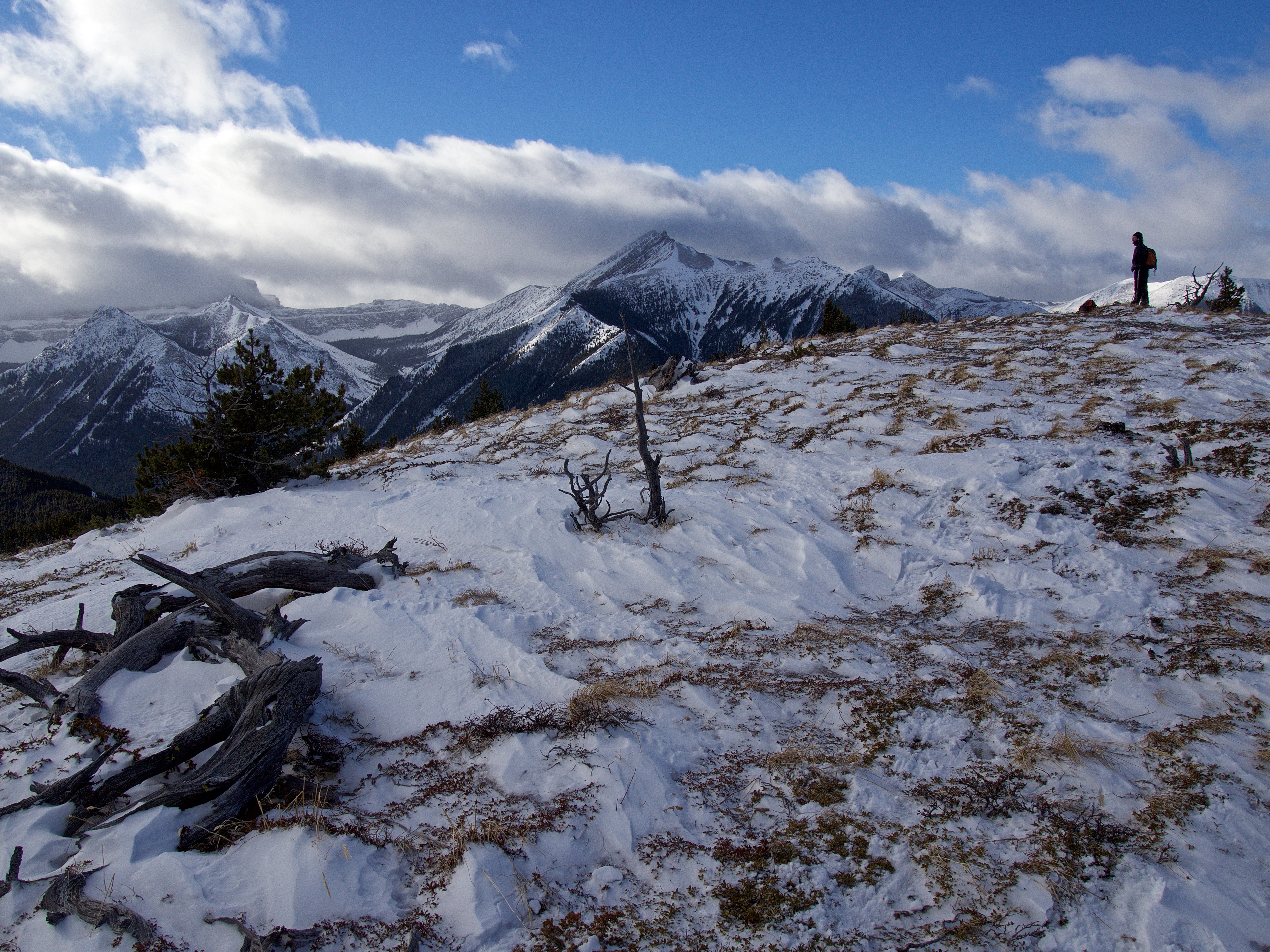
The beginning of the awesome views offered by “Whitney Creek Mountain”. Looking southwest at “Mill Creek Peak” and “Mill Creek Mountain” (far left), North Castle (centre), and Mount Gladstone (right). Hidden by cloud behind “Mill Creek Peak” are Castle Peak and Windsor Mountain.

Looking back along the southeast ridge towards Prairie Bluff (left). (Photo by Brad Wolcott)

Brad makes the easy hike to the summit.

The summit of “Whitney Creek Mountain” (1942 m my GPS).

We found a micro-cairn that we would add to before leaving.

This unassuming summit offers great views in almost every direction! Looking southeast at Victoria Peak (centre) and Pincher Ridge (left). The summit of Victoria Ridge is on the far right.

The view southwest at “Mill Creek Peak” and “Mill Creek Mountain” (left), North Castle (centre), and Mount Gladstone (right). I know I just showed a similar picture from along the ridge, but seriously, on a clear day, both Castle Peak and Windsor Mountain would be absolute standouts on the left.

From left to right: the view west at “Larry Mountain” and “Frankie Peak”, “Eagle Peak”, “Whistable 1”, and “Table Top”.

Also looking west at the summit of Table Mountain. In the foreground is the far north end of Mount Gladstone, and what I’m hoping will be my next snowshoe destination, “Gladstone’s Toe” – don’t ask me why I’m calling it this because I really can’t answer it. 😉 Who knows, maybe an alternate name will come to me while I’m on it?

On the left to the north sits “Blue Mountain”, Burmis Mountain, Tallon Peak, Robertson Peak, “The Dog”, Morin Peak, and the South Peak of the Livingstone Range. On the distant right is Ky-es-kaghd-oghsuyiss (the Porcupine Hills).

Gazing to the northeast at Mount Albert and Piney Point in Beauvais Lake Provincial Park.

Christie Mine Ridge sits to the east. I hiked Christie Mine Ridge in the spring of 2021, but have never published a trip report because I want to respect the privacy of the owner who gave me permission to access his land.

The view southeast at Prairie Bluff (left), Pincher Ridge (right of centre), and Victoria Peak (right).

“Whitney Creek Mountain” sits at the far end of Victoria Peak’s northwest ridge (foreground), but it’s so far removed from the rest of the features on the ridge, that it’s really it’s own entity. Brad and I speculated that the two points in the foreground might also make good destinations. EDIT: We’ve made two trips to the middle section of the ridge that we now call, “Whitney Ridge” and our suspicions were correct, they are great little destinations! 😁

A closer view of “Mill Creek Peak” and “Mill Creek Mountain”.

A closer look at North Castle (left), Mount Gladstone (centre), “Larry Mountain” (right) and its twin, “Frankie Peak” (right).

What a great day to be on a mountain!

I’m not sure our snowshoes were needed at this point… 😉

My best attempt to unleash ‘Magnum’ on the summit. 😉

This summit is really a hidden gem.

Before leaving, I made sure to upscale the little cairn with more rocks and for good measure, a log. I then named it, Edward.

Heading home.

We initially thought about following the ridge all the way to the drainage to see if this would be an easier route. However, the thought of potentially having to break fresh tracks through knee-deep snow (and possibly deadfall) in the drainage, and adding an extra kilometre onto the trip, was nixed in favour of taking advantage of the trail we had already broken.

Pausing beneath the cornice to enjoy the sunshine, some lunch, and some Grey Goose.

Since Brad broke trail most of the way up, I figured the least I could do was take the lead while going down! 😉

A man, a pipe, and a mountain.

Looking down at my 4Runner from above the cliffs.

One of many wipeouts that we experienced on the way down!

Arriving back at my 4Runner after a round trip distance of 2.2 km and a time of 3 hours and 27 minutes.

Looking back towards “Whitney Creek Mountain” as we drive out along the Gladstone Valley Road. We had no idea that this little mountain offered up such great views! While our snowshoe route was definitely the most direct route, other options may also exist, and if you use one, let me know how it goes! “Whitney Creek Mountain” would also make for a great little hike in the spring, summer, or fall, though I would highly recommend waiting for a clear day to maximize everything this hidden gem has to offer.


Leave a Reply