⚠️ Hiking and scrambling are inherently dangerous activities. Please read my Disclaimer. ⚠️
Winter and Mount Carthew are synonymous to me. The last time I was on Carthew, it was the Labour Day weekend of 2015 and Jeff and I were besieged by white-out conditions as we made our way to the summit. This time, it was the Victoria Day weekend, and while the route was totally different, it was nonetheless, an ascent done entirely under winter conditions.
Indeed, recent snowstorms had deposited tons of new snow in the mountains – which we sorely need in southern Alberta – leaving all of the peaks in the area under a beautiful white blanket. With a forecast calling for minimal wind and clear skies until the early afternoon, Mark and Andrew suggested an early start combined with northwest approach via the Akamina Parkway. As my previous experience on the summit of Carthew was devoid of any views whatsoever, I was more than happy to reascend and see what I missed – and boy, were the views ever worth it! 😁
Andrew had successfully used this route in April 2021, but open water in the drainage combined with snow on the upper reaches of his ascent gully, meant we deviated from his route shortly after leaving the Parkway. Instead, we traversed high above the drainage, eventually gaining the northwest ridge via the stunning bowl on the west side of Carthew. As there is no trail into this bowl, nor is it adjacent to any route that would naturally lead one to it, I’m sure that it sees few, if any visitors.
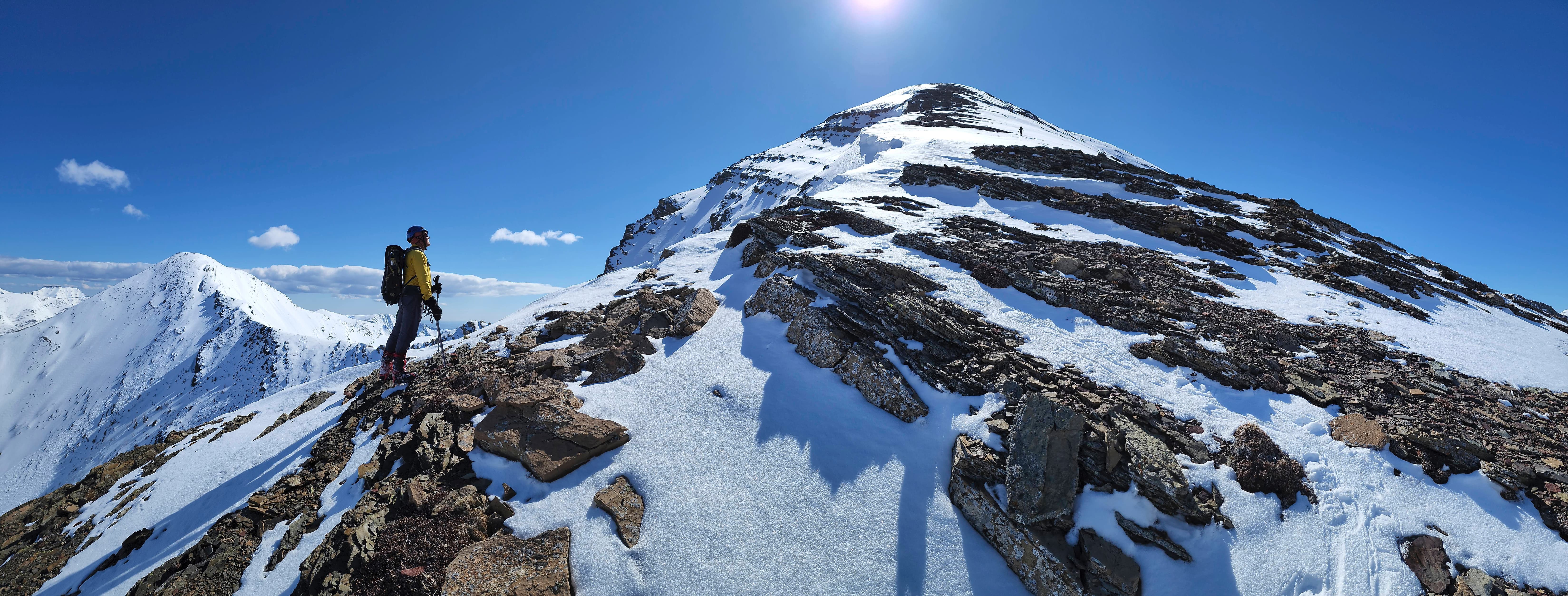
The spectacular winter landscape in the bowl was only matched by the unfolding views as we neared the summit of Carthew, making the massively foreshortened slog up from the bowl worth the effort. Under a clear blue sky, the winter panorama from the top was simply outstanding! The huge cornice on summit of Carthew was breathtaking as were the snow-capped peaks surrounding it. It was truly a picturesque day to be on a mountain and I’m so glad that I was able to repeat this summit. Thank you Andrew and Mark for such a fantastic day! 😁
Be sure to read Andrew’s awesome trip report!

To get to Mount Carthew via the northwest, we used the same starting point as our Buchanan Ridge trip. This meant that we followed the Akamina Parkway to the Rowe Lakes trailhead. From here, we continued driving for another ~1.6 km until we came to a small pullout on our right that was immediately across the road from the 12 km marker post. This was our starting point.
After crossing Cameron Creek, we started along a drainage that leads into the valley between Carthew and Buchanan Ridge. We followed it for approximately ~300 m until it became apparent that there were too many sections of open water for us to snowshoe over as Andrew had done in April 2021. We then headed higher to climber’s right and traversed onto the shoulder of a small ridge where our progress was stymied by a cliff that was impossible to overcome under winter conditions.
We then traversed underneath the cliff searching for a way onto the northwest ridge of Carthew. Approximately 2.7 km from Cameron Creek (not including our foray onto the shoulder which added on another ~800 m), we came to a short, but steep snow gully that we used to gain access to the bowl beneath Carthew.
From the bowl, it was an easy but massively foreshortened ~1.6 km (619 m elevation gain) hike up the northwest ridge to the summit ridge of Carthew. Once on the summit ridge, it was another ~195 m walk to reach the summit. We then returned the same way.

Our total roundtrip distance was 11 km with total elevation gains of 1063 m. Our total roundtrip time was 8 hours and 7 minutes.

Our starting point across from the 12 km marker on the Akamina Parkway. Mount Carthew is in the centre and Buchanan Ridge is on the left.

A closer look at Mount Carthew from the Parkway. The northwest ridge is skyline. (Photo by Andrew Nugara)

Mark crosses Cameron Creek.

Andrew leads as we start along the drainage.

Lots of open water meant that we couldn’t follow the drainage like Andrew did in 2021.

Heading higher to find an alternate route. We wanted to see if we could get over the rock band on the right, but it was a no go with all the snow.

It’s always a good day when you’re on a mountain! 😁

The view down to the Akamina Parkway and Ruby Ridge. (Photo by Andrew Nugara)

Arriving at the first rock band…

And now traversing along its base. Mount Carthew is on the left.

Heading onto the small shoulder above the rock band.

The shoulder offered great views of Mount Rowe.

Mount Carthew is in the centre with Buchanan Ridge on the left.

Heading over to the next cliff band to check for a route.

There might be a way up in the summer, but definitely not today.

Mark and I enjoying the views. 😁 (Photo by Andrew Nugara)

Leaving the shoulder to continue our traverse.

Mark leads as we work our way towards a headwall. Our route onto the northwest ridge will follow on top of the headwall while Andrew’s 2021 route followed beneath it and up the snow gully on the left. The northwest ridge is skyline on the upper left.

Mark’s perspective from the previous photo. (Photo by Mark Nugara)

Searching for a weakness in the cliffs. We would end up using a gully hidden behind the slanted rock in the centre.

My view back to Andrew.

Rounding the corner to enter the gully. (Photo by Mark Nugara)

Starting up the gully. In the summer, this may be a waterfall, but when covered in several metres of snow, it makes for a steep, but convenient way to get above the headwall. 😁 (Photo by Mark Nugara)

Andrew kick-steps a route. (Photo by Mark Nugara)

Looking back shortly after starting.

The steep middle section was the crux of the trip. (Photo by Mark Nugara)

The grade eased as we neared the top.

Looking back as Mark clears the crux.

The Nugara brothers celebrate at the top of the gully. 😁

The bowl under the west side of Carthew was an incredible winter wonderland. As there is no trail into this bowl, nor is it adjacent to any route that would naturally lead one to it, I’m sure that it sees few, if any visitors.

Mark strolls across a frozen tarn as he explores the bowl. The summit of Mount Carthew is on the left

The view back towards the headwall. We were surprised at how much snow there was.

A closer look at the cornice on the ridge above. (Photo by Andrew Nugara)

A pyramid cornice on the same ridge. (Photo by Andrew Nugara)

Leaving the bowl and following the edge of the headwall to the northwest ridge (skyline).

Fantastic shadows under the morning sun.

The view from the headwall back towards the Akamina Parkway (right of centre). The drainage and the small shoulder that we were on earlier, are in the centre.

From here, it became a ~1.7 km foreshortened slog to reach the summit ridge. However, Mark decided to turn on ‘Beast Mode’ and made quick work of the ~619 m elevation – while Andrew and I – the mere mortals that we are – followed at a much slower pace. 😂

Mark and Andrew close in on the northwest ridge. It’s not a difficult hike, but it gets steeper the higher you go, but then again, don’t most hikes? 😂

Up…

And up…

And up we go. (Photo by Andrew Nugara)

Thankfully, we were treated some pretty stellar scenery to pass the time. 😁

Meanwhile, Mark “The Terminator” Nugara continues his torrid pace… 😂

While Andrew and I can only pause to admire him.

Our first views of Cameron Lake (centre). (Photo by Andrew Nugara)

Mark closes in on the summit ridge… (Photo by Andrew Nugara)

Followed by Andrew.

Mark and Andrew wait for me on top.

WOW!! 😁

Mark heads towards the summit. (Photo by Andrew Nugara)

What a gorgeous day to be on a mountain! 😁 (Photo by Mark Nugara)

Super cool scenery!

The impressive cornice on the summit. (Photo by Mark Nugara)

Andrew’s perspective from the previous photo. (Photo by Andrew Nugara)

Arriving at the summit cairn. It was impossible to tell where the cornice started, so we kept well back from the edge.

A pano to the north…

And to the east.

One to the south…

And finally, one to the west.

A closer look at Kinnerly Peak and Kintla Peak, with Forum Peak and Forum Ridge in the foreground.

Gazing into Glacier National Park at Chapman Peak with Mount Carter and Rainbow Peak to the right.

Long Knife Peak looks like it belongs in the Himalayas. 😳

The view west at King Edward Peak (left) and Starvation Peak.

Glancing down into the west bowl and over to Mount Custer (left of centre), Forum Peak, and Cameron Lake.

A closer look at Mount Rowe.

A good look at Piinaquiium / Ahkoinimahstakoo (Mount Blakiston). Recent scholarship by Dr. Ninna Piiksii (Mike Bruised Head / Chief Bird) has uncovered that the Blackfoot had two names for this mountain. The first is Piinaquiium or “seen from afar mountain” and the second is Ahkoinimahstakoo or “pipestone mountain”.

Looking beyond Piinaquiium / Ahkoinimahstakoo (Mount Blakiston) to “Clowdowan Peak” (left of centre), Cloudy Ridge (right of centre), and “Cloudy Junior” (right of centre). In the foreground is Ruby Ridge.

Mount Dungarvan (centre) along with “Dundy Peak” (left), “Cloudy Junior” (far left) and Cloudy Ridge (far left). Buchanan Ridge is in the foreground.

A wider view of the previous photo also shows “Rogan Peak” (right of centre) and Mount Galwey (right). The diminutive, but fun, East Peak of Lakeview Ridge is on the far right.

Zooming in on Bellevue Hill.

Akiiohtaikiistakoo (Bertha Peak) is on the far left with Saakiihmabii (Vimy Peak) to the right of centre. In the centre is Istiikoiistakoo (Sofa Mountain). Again, thanks to the scholarship of Dr. Ninna Piiksii, we are recovering the original Siksikaitsitapi names for mountains in southern Alberta.

Mount Alderson is on my list for 2022. 😁 EDIT: Done!

Niitaaspiitaa (Mount Cleveland) means “only tall mountain” in Blackfoot.

The Nugara brothers channel their inner Ultimate Warrior and Macho Man Randy Savage. 😂

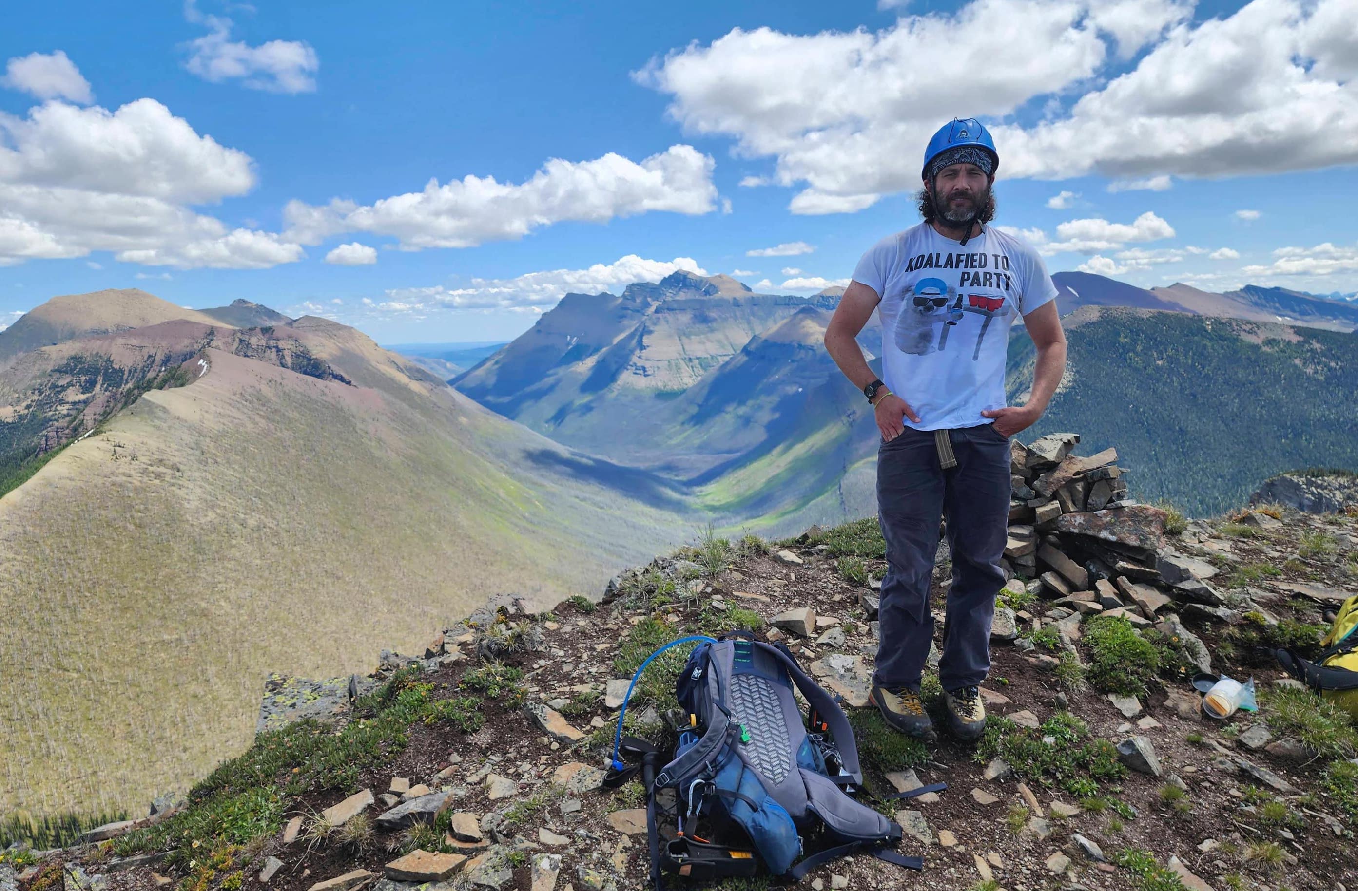
My second time on Carthew – only this time with a view – but sadly, no gorilla suit. 😂 (Photo by Andrew Nugara)

Andrew ventures further along the summit ridge. We had initially thought about returning via the Carthew / Alderson Trail via Summit Lake, but decided against it due to unknown amounts of snow. Better to go with the one who brought you. 😁

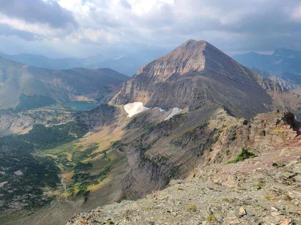
Majestic Chapman Peak (centre) with Mount Carter and Rainbow Peak to its right.

Andrew’s trip to the end of the ridge is justly rewarded! Note the Carthew Lakes (foreground centre) with Alderson Lake on the far left. (Photo by Andrew Nugara)

Looking down at the end of the ridge. (Photo by Andrew Nugara)

A great view of Mount Alderson. (Photo by Andrew Nugara)

Andrew’s view back to Mark and I. (Photo by Andrew Nugara)

Heading back.

Andrew’s view from the previous photo. Don’t worry, I’m standing on solid rock. (Photo by Andrew Nugara)

One last look at Mount Alderson and Akiiohtaikiistakoo (Bertha Peak) (left).

Descending the way we came. (Photo by Andrew Nugara)

What a view! 😁

Mount Lineham is to the right of centre. (Photo by Andrew Nugara)

A quick stop on the way down.

How many ptarmigan do you see? 🤔 (Photo by Andrew Nugara)

Back on the headwall…

And heading into the bowl.

Andrew and Mark lead the way as we descend the crux.

Easy does it! 😁

This was the trickiest part. (Photo by Andrew Nugara)

Instead of following the tracks from our traverse, we dropped further into the drainage. As noted by the fresh releases, the snow had softened quite a bit since the morning. (Photo by Andrew Nugara)

Looking back at the gully.

Enjoying a pleasant snowshoe…

Before things got trickier. 😂

Down-climbing another steep section.

Back on better terrain.

The volume of water in the drainage had definitely increased since the morning.

Note that while Mark and Andrew used hip waders, I strolled through Cameron Creek in my sandals. Look at those pale sticks go! 😂 This was yet another fantastic outing with Mark and Andrew! I’m so glad that we were able to fit this trip into a perfect weather window as the snow combined with a crisp blue sky, made for the ultimate winter landscape. Once again, Paahtómahksikimi (Waterton) proved to be a fantastic place to spend a day!


Leave a Reply