
⚠️ Hiking and scrambling are inherently dangerous activities. Please read my Disclaimer. ⚠️
With conflicting forecasts calling for either moderate wind conditions (50 – 60 km per hour) in the morning or a full-on ripper (100 km+) for the entire day, Andrew and I set out to see how far we could get up the northeast end of Drywood Mountain. In 2019, we – along with Raff and Nancy – enjoyed an early season loop of Drywood’s horseshoe-shaped northeast ridge, where we tagged three small high points that we affectionately nicknamed, “Woody” (2037 m), “Stumpy” (2031 m), and Barky” (2031 m) in keeping with the mountain’s overall theme of ‘wood’.
As luck would have it, the moderate forecast was right and for the first time in a long time, we could enjoy a mountain without killer wind. This didn’t mean it was calm, it just meant that we could stand up and walk without too much effort. Of course, this also meant that we could set our sights on more than just the northeast ridge – we could now try for a small, but rugged peak of 2319 m located just prior to Drywood’s summit ridge. Though a relatively easy scramble in the summer, the presence of ice and snow had the potential to turn it into a more difficult challenge.
As the peak is a distinctive feature on the mountain, I’ve taken to calling it, “The Knot”, in keeping with the mountain’s overall theme. Indeed, from “The Knot”, the actual summit of Drywood is not far off (see Andrew’s 2018 Drywood Mountain trip report) and we were very tempted to keep going. However, no sooner had we reached an even higher point (2349 m), when the moderate wind transformed into extreme gusts that easily surpassed 100 km per hour. This made things not only unpleasant, but dangerous as both Andrew and I struggled to maintain our balance. In fact, I watched Andrew consistently take one step forward and then six steps sideways while I ended up with a nice bruise on my arm after a gust hammered me to the ground. Usually there is a warning that sounds like a rumbling train before a gust arrives, but in this case, it was a sneak attack. Ouch!
After carefully making our way back onto the northeast ridge, we quickly tagged, “Stumpy”, before dropping into the drainage located between the two arms of the ridge. Here, we enjoyed a few sections of glissading, before snowshoeing the remainder of the drainage back to the road, followed by a short hike to reach our vehicles.
While it’s too bad that we couldn’t continue to the summit of Drywood, I’m super happy that we achieved some decent elevation for the middle of January. Indeed, these front range high points in the Castle make fantastic winter and shoulder season objectives given the short days and colder temperatures. In the summer, you would speed past most of these high points on your way to an actual summit; however, in the winter they provide great exercise, decent elevation gains, and some good views. They are decidedly fun places to play! 😁

To get to the northeast end of Drywood Mountain, I drove ~19.5 km south of Pincher Creek on Highway 6 until I reached the Shell Waterton Plant Road (Township Rd. 43A). I then turned onto this road and drove west for ~9.1 km until I come to a junction with a gravel road near the entrance of the plant. I turned left and onto this gravel road which leads to the Forest Reserve, and I continued for another ~3.9 km until I reached Butcher Lake. Here, I turned left and onto another gravel road immediately prior to the lake and followed this road for another ~1.4 km until I came to a junction with a road on my left. I turned left and followed the road for ~2.7 km until I came to a gated entrance for a gas well on my right. This was our starting point.
From the gate, we hiked the road for ~60m until we came to a fork. We took the right fork, which is an old road, and followed it until we came to a sharp bend that led up to our right. Here we left the road and continued straight, following alongside a barbed wire fence. Eventually, we arrived at the base of the northernmost arm of the northeast ridge, where we proceeded to make the steep hike (~300 m elevation gain) to reach the far end of the ridge.
Once on the ridge, it was a ~510 m hike to reach “Barky” (2031 m) and then another ~390 m to reach “Woody” – which is tallest of the 3 high points on the horseshoe ridge at 2037 m. From “Woody” we descended to the col with “The Knot” where it was another ~847 m in hiking coupled with a ~247 m elevation gain to reach the summit. We then continued on from “The Knot” to reach another high point that was ~282 m away with an elevation gain of 30 m.
From here, we returned the way we came, except from the base of “The Knot” we made the short trip to “Stumpy” (2031 m) on the southern arm of the horseshoe. We then dropped into the intervening drainage and followed it all the way back to the road and our vehicles. From the top of “Stumpy” to our vehicles it was ~2.3 km.

Our total distance travelled was 7.5 km with total elevation gains of 858 m. Our total roundtrip time was 5 hours and 7 minutes.

Our starting point at the entrance to the gas well. “The Knot” is in the distant centre.

Getting a better look at “The Knot” (left) from the old gas road. (Photo by Andrew Nugara)

Leaving the road to follow a fence.

Nice! There was a convenient path next to the fence.

Arriving at the base of northern arm of Drywood’s northeast ridge.

It didn’t take long for the slope to steepen.

It’s always a joy to experience sunrise from a mountain. 😁

Getting into a bit of scrambling. (Photo by Andrew Nugara)

Andrew navigates his way through the rocks.

Getting closer to the top.

Arriving at a small rock band just below the ridge.

The views begin to open as we arrive on the ridge.

After weeks of either intense cold or intense wind, it was nice to enjoy a more moderate day.

A small cairn sits on the far end of the ridge. “The Knot” is in the centre while the summit ridge of Drywood is on the right.

A quick look to the south…

And then to the west.

That’s a lot of gear… I put my gloves on my pack so that I can pat myself on the back. 😂

We are not alone!

Andrew leads the way as we make our way along the ridge.

Hello there!

Heading towards “Barky”, the first of two high points on the northern arm.

Arriving on top of “Barky” (2031 m).

The view back along the ridge.

Looking across to the southern arm with “Stumpy” (2031 m) in the centre. We would visit “Stumpy” on the way back.

Gazing across to Pincher Ridge. That treed bump in the foreground might be a cool place to snowshoe one day…

Morning sunlight on Prairie Bluff (right of centre). In the foreground are “Cinch Hill” and “Bridle Peak” which are located on the northeastern end of Pincher Ridge.

“Barky” has some cool twists to it.

Andrew leads the way onto “Woody” (2037 m).

Looking back at “Barky” from the summit of “Woody”.

There he is! The twisted face of Woody himself.

With the wind still tolerable, it was time to head to “The Knot” (centre).

Gazing up from the col.

Andrew soaks in the view.

Getting into some scrambling.

Glancing back at both arms of the northeast ridge. After tagging “Stumpy” (right), we would follow the drainage in the centre back to the road.

In the summer, this would be a fairly easy scramble…

However, in mid-January a good chunk of the rock is covered in ice, which makes things a bit more challenging.

Andrew carefully negotiates a section of ice.

Not only were there great views, but we were sheltered from the wind.

A wide angle of the previous photo.

Good ol’ Prairie Bluff (right) where I encountered some insane wind last week.

Continuing to scramble our way up.

It’s always a treat when you can enjoy scrambling in January. 😁

Nearing the top.

I climb over the final section of rock. (Photo by Andrew Nugara)

On the shoulder and looking at “The Knot” (centre).

A cool silhouette photo by Andrew!

My view from the previous photo.

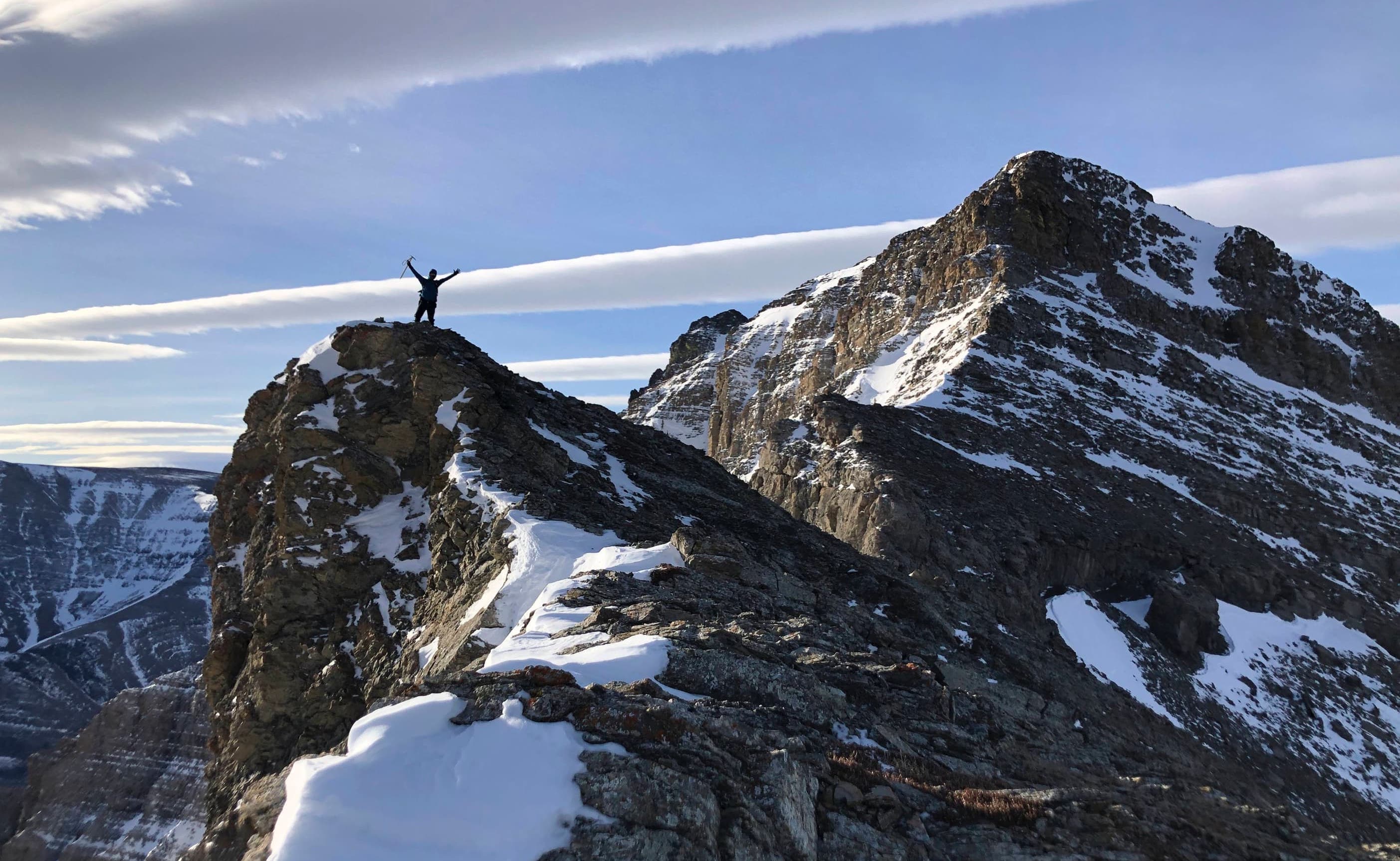
On the summit of “The Knot” (2319 m). (Photo by Andrew Nugara)

Gazing to the north…

Then to the east…

And finally to the west.

A telephoto of Ninastako with Lakeview Ridge at middle distance. Coming closer are “The Eaglet” and “Raptor Peak” on the northeast end of Spread Eagle Mountain, and finally, in the foreground are “The Muffin” and “The Croissant” on the northeast end of Loaf Mountain.

A better look at “The Muffin” and “The Croissant”.

One of my favourite scrambles on the front range of the Castle is “Bakery Peak” (centre) which is located on the northeast end of Loaf Mountain. Those jagged pinnacles on the summit are uber cool!

“Pastry Peak” (centre) is the one place on Loaf Mountain that I’ve yet to visit. Maybe this winter… 😁 EDIT: Done! On the far right is Spionkop Ridge.

Looking down the valley at the Centre Peak of Pincher Ridge (centre)…

And then zooming in on Windsor Mountain and Castle Peak.

Pincher Ridge was stunning today.

It was great to see so much snow on the Flatheads! On the far left is Mount McGladrey followed by Ptolemy SE5 (left) – which is near the top of my list for 2022. 😁 Mount Coulthard (right) looks especially brilliant as does diminutive Mount McLaren (far right).

Another look at what I call the Prairie Bluff family: Prairie Bluff, “Prairie Fire”, “Prairie Oyster”, “Prairie Sky”, and “Prairie Storm”. So much fun in one picture!

A telephoto onto the north end of the Flatheads and into the Crowsnest Pass. From left to right: Mount Coulthard, Mount McLaren, Crowsnest Ridge, Philipps Peak, Mount Tecumseh, and “Deadman Peak”.

A closer look at Hillcrest Mountain (left), Omahkai’stoo (Crowsnest Mountain) (centre), and Turtle Mountain (centre).

I rebuilt the existing cairn and named it ‘Buzz’ as an homage to “Woody”.

Another look to the northwest.

Deadwood on top of “The Knot”. 😂💀 (Photo by Andrew Nugara)

After enjoying the views, while also noting the rapidly increasing wind velocity, we decided to head towards the next high point (centre).

I can’t get enough of that view over to Pincher Ridge!

Approaching the base of the next high point. (Photo by Andrew Nugara)

Negotiating some exposure. (Photo by Andrew Nugara)

Heading up. (Photo by Andrew Nugara)

My view to the summit ridge from the top of the high point (2349 m). The summit of Drywood is just poking over to skyline left.

Looking back to “The Knot” (left).

Andrew used the gully on the right to get onto the summit ridge in 2018. However, he said that as it was very exposed, he would recommend some technical gear for a winter ascent. We then contemplated traversing across to reach the north ridge which would lead us directly onto the ridge. The wind though, had other plans as it began to blast us relentlessly. Being completely exposed to its wrath on the summit ridge would not be pleasant. I will however, return to re-ascend Drywood using this route. 😁

Andrew carefully down-climbs from the high point.

Almost back at the base.

Heading back to “The Knot”…

And then returning back to the northeast ridge.

Easy does it!

Another view of the northeast ridge.

Andrew passes an interesting pillar.

Heading over to tag “Stumpy” which is the highest point on the southern arm. “Woody” and “Barky” are on the far left.

On top of “Stumpy” (2031 m).

The east side of “The Knot” from “Stumpy” with the summit of Drywood visible on the left. (Photo by Andrew Nugara)

Descending into the drainage.

I sure hope that snow is hard-packed; otherwise it is going to be a long trip back.

Enjoying one of several sections where we could glissade.

It was a quick trip from “Stumpy” to the bottom of the drainage.

Andrew descends what I’m assuming is a small waterfall during run-off.

Thankfully, the snow was accommodating.

Bend it like Beckham.

Looking back at “The Knot” – and the Knob – from inside the drainage. 😂💀 (Photo by Andrew Nugara)

A more comprehensive look back as we near the road.

Back on the road with the wind at our backs.

Arriving back at our vehicles after a fun trip that was just over 5 hours. I have to say, I’m starting to get annoyed by the wind. I’m not sure if it’s just that I’m an old man or if it’s actually windier this year – or both – but I feel like I’ve been restricted in my choice of destinations more than usual over that past couple of months. Oh well. I won’t begrudge the great morning of moderate wind that we had, because it allowed us to get to the top of “The Knot”. Oh, and we could get up “The Knot” because the wind had blown all the snow off, so there’s that too. 😁 Finally, and as always, it was fantastic to spend yet another day on a mountain with my good friend, Andrew.


Leave a Reply