

⚠️ Hiking and scrambling are inherently dangerous activities. Please read my Disclaimer. ⚠️
From the summit of “Sapper Peak”, the routes to both SW3 and SW1 were obvious. Though SW3 was our initial target, once we saw SW1 it was a no-brainer to make that our priority. Sitting only 35 m lower than Saint Eloi (which I’ve somehow neglected to visit), SW1 is joined to “Sapper” via a gentle connecting ridge (~1.7 km from summit to summit). The ridge is broad and the views are fantastic, with the highlight being the large, unnamed lake that sits beneath it.
Looking down at this lake, it’s hard to fathom why it doesn’t have a name. It’s deep with sharp drop-offs and looks very capable of holding a population of fish. On further inspection, we could see what looked to be a decent trail leading from the outlet of the lake and down the valley, where I would guess that it connects with the Flathead Fire Service Road (FSR) near to the ranger station south of the Pollock Recreation Site. Given the condition of the trail coupled with the obvious depth of the lake, I think it would be a safe bet that this lake holds a healthy fish population and is probably a local backcountry haunt. I quickly looked on the BC Fish Stocking Report, but couldn’t find anything for 2022 or 2023, but that doesn’t mean much. I’m willing to bet there are fish.
The summit of SW1 offers excellent panoramic views especially of nearby Syncline Mountain, Saint Eloi, and onto the southern end of the Flatheads. We discovered that if we descended a short distance from the summit to northwest, we had a good view of a second unnamed lake. Judging by its depth and topography, I doubt this one holds a population of fish, but it was a very pretty green. By traversing to the col on the ridge that separates the lakes, it was possible to see both lakes at once.
The temptation to continue over to Saint Eloi was real, but because we had left our bikes at Haig Lake, that wasn’t an option – nor did we have enough water. Besides, Rick Collier describes the route between the two peaks as “serious scrambling” with “some tricky and exposed moves” and if there is one thing I’ve learned over the years, if Collier says something is serious, then it’s “pee my pants” territory for me. 😳
After returning to “Sapper Peak” under intensifying heat, we thought about, but rejected the notion of continuing to SW3 due to a lack of water. We had both brought 5 litres, but the heat was forcing us to deplete our supplies quicker than usual. As SW3 is the lowest peak on the ridge, I don’t feel too bad about missing it and I wouldn’t mind returning one day, but under cooler temperatures and when there is still snow on the ridge to use for refilling.
Again, I’d recommend reading Rick Collier’s 2006, ‘St. Eloi to Haig Traverse’ as well as Greg Jones’ 2021, ‘Saint Eloi SW3 and SW1 via the West Castle. Both approach the ridge from the opposite side, with Jones ascending from the Syncline Brook trail and then scrambling up beside a waterfall into the valley between SW1 and “Sapper Peak”.
This trip undoubtedly ranks as one of my top ridgewalks in Tatsiki-Miistáki (Castle) and a huge thank you to Andrew for suggesting it! 😁 Be sure to read his fantastic trip report!

To get to Saint Eloi SW1 and “Sapper Peak”, we drove south from the hamlet of Beaver Mines on Highway 774 until we arrived at the parking lot for the Castle Ski Resort. This was our starting point.
From the parking lot, we biked the south Haig Lake trail for ~4.5 km (385 m elevation gain) until we reached Haig Lake. We then stashed our bikes in the trees and headed past the lake and towards the base of the Gravenstafel Ridge / Mount Haig col. We chose to head for an obvious gully on the north end of the col and stayed in it or beside it until we were parallel with the col. We then traversed a short distance over to the col. From the lake to the col it was ~1.3 km with an elevation gain of 265 m.
From the col, we then scrambled for another ~864 m (185 m elevation gain) until we reached the top of the ridge at the base of Mount Haig. We then descended along the ridge to a small highpoint that was located ~1 km to the northwest (95 m elevation loss then a 40 m elevation gain). The highpoint is larger than it looks from Haig, and we would avoid regaining its elevation on return by following a very obvious goat trail.
From the top of the high point, we descended to the lowest point on the ridge (120 m elevation loss) that was located ~670 m away. From here it was mostly an uphill hike (with a couple small dips) for ~1.6 km (247 m elevation gain) to the start of the ridge on “Sapper Peak”. This is the point where the ridge swings to the southwest and the summit of “Sapper” sits only ~600 m away.
In total, the summit of “Sapper Peak” (2375 m) sits ~4 km from the point where we gained the ridge at the base of Haig and ~11 km from the parking lot at Castle Ski Resort (921 m elevation gain). It took us 4.5 hours to reach it.
From “Sapper”, the summit of SW1 sits a further ~1.7 km to the northwest along a gentle connecting ridge (50 m elevation loss and 130 m gain). It took us 30 minutes to reach from “Sapper” and 5 hours from the start. The highlight between the two peaks is the view of the unnamed lake that serves as the headwaters for Packhorse Creek. We discovered that if we descended a short distance from the summit to northwest, we had a good view of a second unnamed lake. By traversing to the col on the ridge that separates the lakes, it was possible to see both at once.
We then made an easy traverse underneath the summit of SW1 and back onto the ridge, which we followed to the summit of “Sapper”. To reach SW3 would’ve added another ~3 km (~1.5 km there and back) and probably another 400 m in total elevation gains onto our trip. Under the scorching sun we realized that we would not have enough water left to reach Haig Lake if we committed to SW3, and made the decision not to ascend it.
From the summit of “Sapper” we returned the way we came except we avoided regaining the elevation of the high point prior to Haig by using a very obvious goat trail that led from col to col. The scramble off Haig is tedious with the worst seection being the descent off the Gravenstafel / Haig col back to the lake. The dirt and scree terrain sucks. Once on our bikes, it was a quick descent back to our vehicles.

Our total roundtrip distance was 25 km with a total roundtrip time of 9 hours and 50 minutes. Total elevation gains came in at 1652 m.

Andrew leads us off “Sapper Peak” and along the gentle ridge that connects to Saint Eloi SW1.

Looking over at Saint Eloi SW3 and the large unnamed lake that serves as the headwaters for Packhorse Creek.

A closer look at the lake.

Looking to the west.

Andrew chose a lower line so he could get a better view of the lake.

Glancing back to the summit of “Sapper Peak”.

Approaching the gentle climb to SW1. It is ~1.7 km from the summit of “Sapper” to the summit of SW1 with a 50 m elevation loss and a 130 m gain.

The connecting ridge to Saint Eloi doesn’t look too fierce from this angle, but Collier noted it contained “serious scrambling”.

The view back and along the very broad ridge. (Photo by Andrew Nugara)

Following a pleasant curve to the summit.

Andrew’s view from the previous photo. (Photo by Andrew Nugara)

The summit of SW1 (2469 m). There was a small cairn that hosted a massive swarm of flying ants. 😳

A pano to the north…

And then to the northeast.

Looking east…

And finally to the south.

Saint Eloi (right) and all three peaks of Syncline Mountain.

A closer look at Saint Eloi…

And then at Peak 1 (right), Peak 2 (centre), and Peak 3 (left) of Syncline.

Good ol’ Mount McCarty (centre). Now those are some bushwhacking memories! 😂

The south end of the Flathead Range featuring Hollebeke Mountain (foreground), “South Flathead Peak” (left), Centre Mountain (left of centre), Centre SE1 (centre), and Centre N1 (right).

Speaking of running out of water, may I introduce you to Mount Borsato? 😂

On my ‘To Do’ list is Mount Darrah (centre). On the right is Mount Ptolemy, the largest peak on the range.

Gazing over to Centre E3 (centre) and behind it, Darrah S2.

Zooming in on Mount Coulthard (right of centre).

Bringing the distance back with Packhorse Peak.

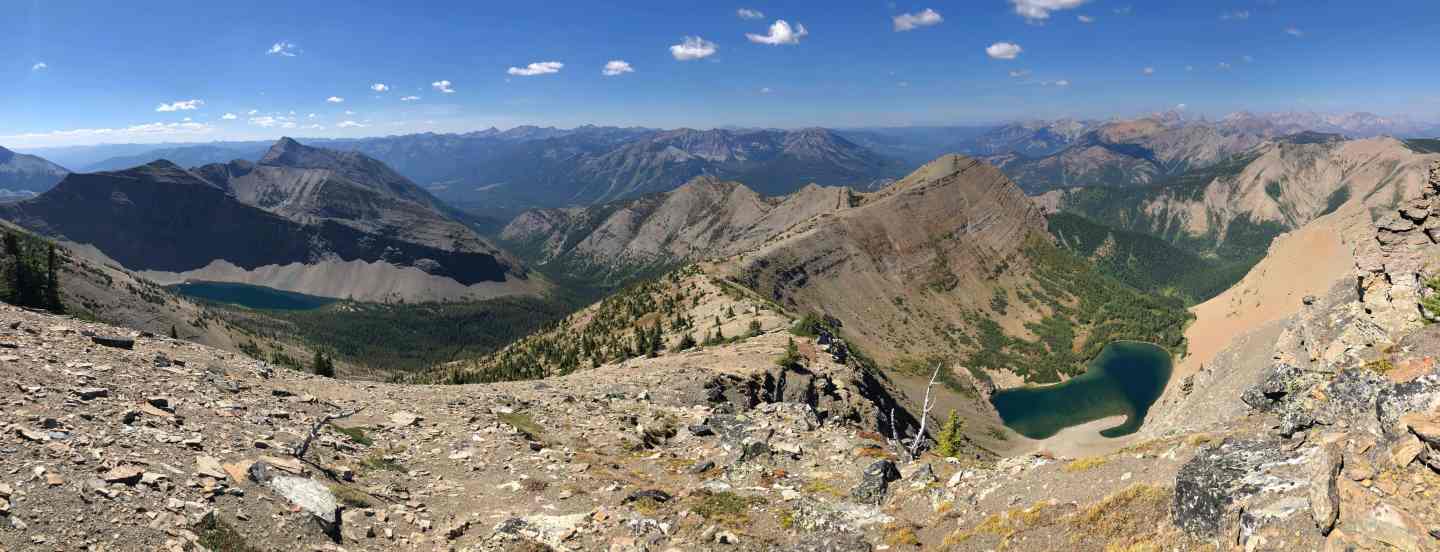
Packhorse, SW3, and that sweet lake!

Another look at the lake. Note the steep drop off from the shoreline. For alpine trout, the drop into deep water is their safety net. Most of their food comes from aquatic insects and terrestrials in the shallower zones and when spooked, the fish retreat quickly into deep water. If I have a way of getting onto the water in an alpine lake, I like to float closer to the middle and cast towards the shoreline.

Tombstone Mountain is another peak that I need to visit.

Rick Collier’s aptly named, “Boot Hill”, is connected to Tombstone (far right).

Mount Haig – the point where we gained the ridge seems awfully far away… 😳

Way off in the distance sits Piinaquiium (Mount Blakiston).

Now looking at Gravenstafel Ridge.

Speaking of awesome ridgewalks in Tatsiki-Miistáki (Castle), here is Lys Ridge (centre).

Looking at all three summits on Barnaby Ridge: Southfork Mountain (left), “The Amoeba” (centre), and the summit of Barnaby Ridge. In 2017 I was part of a trip that traversed the entire ridge from Southfork Mountain to Grizzly Lake.

Gazing past Barnaby and looking at Victoria Peak (centre) and Victoria Ridge (right).

Mighty Prairie Bluff! To date, I’ve summited it 6 times using 4 different routes. Andrew is still the all-time PB champ though. 😁

The first of two unnamed peaks on the McDonald Range…

And now the second peak.

Lots more panos to come! (Photo by Andrew Nugara)

Andrew on the summit…

Apparently followed by an aging member of an obscure ’80s rock group. 😂 (Photo by Andrew Nugara)

We wanted to see the second lake, so we made the very short trip to the northwest end from the summit. (Photo by Andrew Nugara)

On a clear day, you can see so many different ranges from SW1. (Photo by Andrew Nugara)

More big views. (Photo by Andrew Nugara)

Descending a short ways to see the lake. Note the cool little peak on the right.

The second lake and that cool little peak above it. (Photo by Andrew Nugara)

Get ready for a bunch of panos courtesy of Andrew! 😀 (Photo by Andrew Nugara)

The valley into this lake is also very interesting. (Photo by Andrew Nugara)

Judging from the topography, I don’t think this lake would hold fish, but I could be wrong… (Photo by Andrew Nugara)

A closer look. There are definitely places to camp if you were to visit it. (Photo by Andrew Nugara)

And now the piece de resistance: both lakes together! 👏 (Photo by Andrew Nugara)

The ridge continues off of SW1 and eventually ends near the Flathead Fire Service Road. (Photo by Andrew Nugara)

Another look at the first lake. We could see a definite trail leading from the lake and down the valley.

Instead of regaining the summit, we made an easy traverse back to the ridge.

Andrew’s view from our traverse. (Photo by Andrew Nugara)

Andrew rejoins me on the ridge.

Heading back to “Sapper Peak” (left).

The view down the valley that Greg Jones used to access the area in 2021.

Looking back at SW1.

At this point we were still debating whether to continue on to SW3. Here, Andrew makes a quick descent to check out the route to SW3. The scorching heat had forced us into consuming more water than we anticipated, so we made the wise decision to hold off until another day. Remember, the saying: “There are old climbers and there are bold climbers, but there are no old bold climbers.”

Leaving the summit of “Sapper”.

Continuing along the summit ridge of “Sapper”.

The view over to SW1 (left) and Saint Eloi (right).

Approaching the point where the ridge swings toward Haig.

We weren’t looking forward to losing and regaining the elevation back to the shoulder on Mount Haig (right).

Still enjoying the panoramic views!

One last look at SW1.

Heading back.

More big views from the ridge. (Photo by Andrew Nugara)

Getting closer to the lowest point on the ridge.

Gazing at the headwaters of Cate Creek. “Boot Hill” is in the centre with Tombstone Mountain on the right. (Photo by Andrew Nugara)

More of the same! (Photo by Andrew Nugara)

The high point closest to Haig may look small from the opposite side, but from here it’s very impressive.

To avoid regaining the high point, we followed a fantastic goat trail.

Glancing back to ‘Sapper Peak” (centre) as we begin our traverse around the high point.

Hooray for goats!

Andrew’s view back. (Photo by Andrew Nugara)

The last real elevation gain of the day will be getting onto the shoulder where we gained the ridge.

Andrew leads the way up.

His view back. (Photo by Andrew Nugara)

Another look back at “Sapper” (left), the summit of SW1 (centre), and Saint Eloi (right).

An even closer look at “Sapper” and SW1 from the same vantage as the previous photo.

Heading down to the Gravenstafel / Haig col.

The view down to Haig Lake.

Carefully picking our way down.

Navigating a short section near the edge.

Almost through most of the scrambling.

Argillite pillars and Dave. 😂 (Photo by Andrew Nugara)

The heat was perhaps the biggest crux, but second to it was the descent from the col to the lake. The scree / dirt / tussock terrain sucked to descend.

Continuing with our tedious descent off the col.

Looking back.

Getting closer to the lake.

The final section of rubble before we enter the trees.

Back on the trail!

For a beautiful Sunday afternoon, it was surprising not to see anyone at the lake.

I stick my head in the lake to cool down – and kill the entire aquatic ecosystem. 😂 (Photo by Andrew Nugara)

The view back to the col.

Making the short walk to our bikes. (Photo by Andrew Nugara)

Thankfully they were still there!

Though I had to push my bike up, going down was super fast…

Until I popped my rear tube about 2/3 of the way down. Damn it! 😢

I had a spare tube with me, but figured it would be easier to walk the remaining 20 minutes rather than spend an equal amount of time putting on a new one. (Photo by Andrew Nugara)

Arriving at the trailhead…

And then back at our vehicles. This was a super fun trip that ticked all the boxes: great views, clear skies, new terrain to explore, and all done with a great friend. I look forward to coming back one day to tag Saint Eloi and then some of the other peaks like “Boot Hill” and Tombstone.