
⚠️ Hiking and scrambling are inherently dangerous activities. Please read my Disclaimer. ⚠️
It felt good to be back in the mountains after a number of weeks away. A sudden, family medical emergency at the beginning of October meant that my time has been dedicated to far more important things in life. Thankfully, we found ourselves under the excellent care of Dr. Par Boora (Hiking with Par ), whose superb skill and expertise as a surgeon saved the life of my spouse. I know I’ve said it in past trip reports, but I will say it again: I am incredibly grateful for our universal health care system and for all of the doctors, nurses, and health care professionals who work in within it. You are all heroes! And thank you again Dr. Boora, words cannot begin to express our gratitude.
Given the circumstances, it may seem odd that my first hike since September would be up a destination with the morose nickname, “Suicide Hill”. However, this small shoulder season objective has been on our radar for a number of years and after so many weeks away, it would serve as the perfect conditioning stint to regain my ‘mountain legs’.
Located immediately to the north of Syncline Mountain in Castle Provincial Park, “Suicide Hill” is a 1989 m standalone that is easily accessed from Highway 774 via the Great Divide Trail (GDT). We came up with the name because of its proximity to Suicide Creek, but I’m sure there are other unofficial names out there, so don’t take it as the end-all-be-all.
At any rate, Brad and I attempted it as a snowshoe last year, but deep snow alongside the highway, made parking an impossibility, leaving us with the sole option of starting from the Syncline Cross Country Ski area which would’ve added ~3.6 km onto the trip – all along a busy highway with no shoulder. So, we took a pass in favour of Carbondale Ridge and Carbondale Hill. Fast forward to today and at Brad’s suggestion, we were back for another try – this time with our good friends, Andrew and Lance.
At Brad’s prompting, we decided against starting from the GDT trailhead, instead venturing several hundred metres down the highway, until we were at the base of a small, but intriguing ridge that we could see from the road. Brad’s ingenious plan was to ascend the ridge – which we affectionately came to call, “Great Little Ridge” (GLR) – until we intersected with upper section of the GDT. From here, we would follow the main trail and then a secondary trail until we were at a point where we could bushwhack our way to the top of “Suicide Hill”.
As I’ve said on many occasions, ‘Always bet on Brad!’ and today was no exception. His plan worked like a charm and not only did we get to enjoy the great views from the summit of “Suicide Hill”, we had a fantastically scenic ascent of GLR – which ended up being a great little shoulder season destination in and of itself. 😁 That I was accompanied by three great companions, meant that most of the day was spent in laughter and good conversation.
I’m sure “Suicide Hill” is a popular objective as it meets all the criteria for a shoulder season outing: easy access combined with great views and a relatively short timeline to complete. I will definitely add both destinations to my long list of small, but fun foothills to explore in the Castle. 😁

To get to “Great Little Ridge” (GLR) and “Suicide Hill”, we drove south from Beaver Mines on Highway 774 for ~21 km until we came to the base of GLR on the righthand side of the road – just prior to reaching the usual starting point for Syncline Mountain. For further reference, our parking spot was ~4.4 km from the entrance to the Syncline Cross-Country Ski Area parking lot or ~750 m from the bridge over Suicide Creek. Just in case you were wondering, the GDT trailhead is located ~3.6 km from the Cross-Country Ski Area parking lot.
From the highway, we made the steep ~360 m hike to the crest of GLR in relatively quick time. It did involve a bit of a scramble through a weakness in the cliff band, but this could be avoided entirely by gaining the crest further to the south.
Once on the crest it was a delightful ~1.9 km hike to reach the summit of GLR (1765 m). After enjoying the views, we continued towards “Suicide Hill” by descending through the trees for ~500 m until we intersected the GDT close to where it forks to reach either Syncline Mountain or Lynx Creek. Here, we stayed to the right (Lynx Creek) and followed the trail for ~550 m until we came to Suicide Creek.
After crossing the creek, we followed the trail for another ~170 m until we came to an old secondary trail leading off to our left. Here, we left the main trail and followed the secondary trail for ~350 m until it eventually became a single-track path. This is where we left it to bushwhack our way to the summit ridge of “Suicide Hill”. Once on the ridge, it was an easy hike to reach the actual summit (1989 m).
To descend, we opted to follow an open section of slope all the way back to a small section of trees just prior to reaching the secondary trail. This minimized the bushwhacking and prolonged the great views. For reference, we emerged back onto the secondary trail ~140 m from where it joins the GDT. If I come back again, I may use this route for ascent.
Once back on the GDT we followed it all the way back to where we joined it from GLR. We then continued to follow the trail until we had almost reached its trailhead along the highway. However, to save time, we opted to follow a smaller path that led back towards our starting point on GLR, before it eventually gave way to some light bushwhacking. After ~500 m of travel through the trees, we emerged onto the highway ~200 m from the bridge over Suicide Creek. From here it was a short walk back to our vehicles.

Our total roundtrip distance was 9.2 km with total elevation gains of 709 m. Our roundtrip time came in at 4 hours and 10 minutes.

Our parking spot alongside Highway 774 at the base of “Great Little Ridge” (GLR).

Brad leads us into the woods (cue Sondheim’s musical score 😂) as we head towards GLR.

Drawing closer to GLR’s initial cliff band. If we had started further to the south (climber’s left) we could have avoided this altogether.

Searching for a way up. (Photo by Andrew Nugara)

Andrew leads us around a corner.

We would’ve bypassed GLR altogether if Brad hadn’t suggested it. As I’ve come to say, “Always bet on Brad”. 😁

Success! Andrew discovers a steep but easy route through the cliffs.

Twenty minutes after starting, we were on the crest of GLR. With the names Brad, Andrew, Lance, and Dave, we already have the acronym for our forthcoming middle-aged rock band: B.A.L.D.. 😂

Clouds sweep over Mount Haig (left) and Gravenstafel Ridge.

Syncline Mountain provided a scenic backdrop for most of the day.

Gazing back along the lower section of ridge.

A pano that highlights the first peak of Syncline and the impressive cliff face of GLR. We came up with the nickname GLR because we kept commenting what a ‘Great Little Ridge’ it was. (Photo by Andrew Nugara)

Brad and Lance lead us towards the next high point.

Though easily avoidable, Brad scrambles up a small section of rock. (Photo by Andrew Nugara)

Another look back but with a more comprehensive view of Southfork Mountain.

It was hard not to take a bazillion photos of Syncline Mountain. 😁

We came across this unusual contraption along the ridge…

Which sparked an intense debate as to whether it was related to research being conducted at the nearby University of Lethbridge field station, or if it was left by witches. We came to the obvious and rational conclusion that it had been left by witches. 😂

While Lance enjoys the views off to the east, Brad and Andrew take in the view to the south…

Which was this.

An easy but enjoyable ridge walk. (Photo by Andrew Nugara)

Another look back.

The summit of “Great Little Ridge” (1765 m) with a portion of “Suicide Hill” in the background.

A pano to the north.

The view back to Southfork Mountain.

Heading off the summit and into the trees as we make our way towards “Suicide Hill”.

Brad always wears ‘interesting’ shirts while hiking and today’s choice was a sleeveless AC/DC hoodie.

Easy travel through the trees.

Approximately 500 m from the summit of GLR, we arrived on the Great Divide Trail (GDT) which would take us to the base of “Suicide Hill”.

Not long after joining the trail, we came to a fork where we would keep to the right.

“Suicide Hill” can be seen through the trees as the trail descends towards Suicide Creek.

Andrew leads the way as we make good time along the well-kept trail.

Andrew crosses Suicide Creek…

Followed by Brad.

Continuing to follow the trail after crossing the creek.

However, we would only follow the GDT for another ~170 m. Once we came to this sign, we would take a secondary trail that would lead us closer to “Suicide Hill”.

Leaving the GDT (left) and starting up the secondary trail.

The old trail had seen its share of erosion – kind of like me, now that I’m in my fifties. 😂

Continuing along the secondary trail. On the way back, we took advantage of open slopes and arrived back on this trail only ~140 m from its junction with the GDT. However, those slopes are not visible from the trail and at this point, we didn’t know where the trail was leading, so we kept following it.

Approximately 350 m from its junction with the GDT, the trail becomes little more than a single track path. As the bushwhacking looked to be light, this is where we would leave the trail to head up “Suicide Hill”.

Thankfully, all of the bushwhacking we encountered was relatively easy to navigate.

Lance takes advantage of a brief opening in the trees.

The slope was steep but we made good time.

Nearing the top of the ridge…

This was not the summit, but it was the part of “Suicide Hill” that we could see from GLR and the GDT. It was a great spot to enjoy lunch!

Looking to the southeast…

And now to the south.

Southfork Mountain towers above the summit of GLR – which is the little bump in the foreground centre.

The summit of Rainy Ridge pokes through the clouds.

The first peak of Syncline Mountain.

A cloud seemingly balances itself on the summits of Castle Peak and Windsor Mountain.

Looking across the valley to Table Mountain (left), “Table Top” (centre), the “Whistables” (right of centre), and Whistler Mountain (right) with Frankie Peak and Larry Mountain behind it.

Directly to the east sits “Beaver Mines Ridge” (foreground) with Mount Albert on the right.

A closer view of the fire lookout on Carbondale Hill.

Mount Backus is a worthy snowshoe destination.

My all-time favourite foothill, “Blue Mountain” with “Screwdriver Ridge” in front of it.

A telephoto of the the south end of the Livingstone Range highlights Centre Peak, Caudron Peak, the “South Peak”, Morin Peak, and “The Dog”.

After enjoying a leisurely lunch, it was time to head to the actual summit.

We were anticipating the summit to be treed, but to our pleasant surprise, the terrain opened up the higher we went.

Almost there.

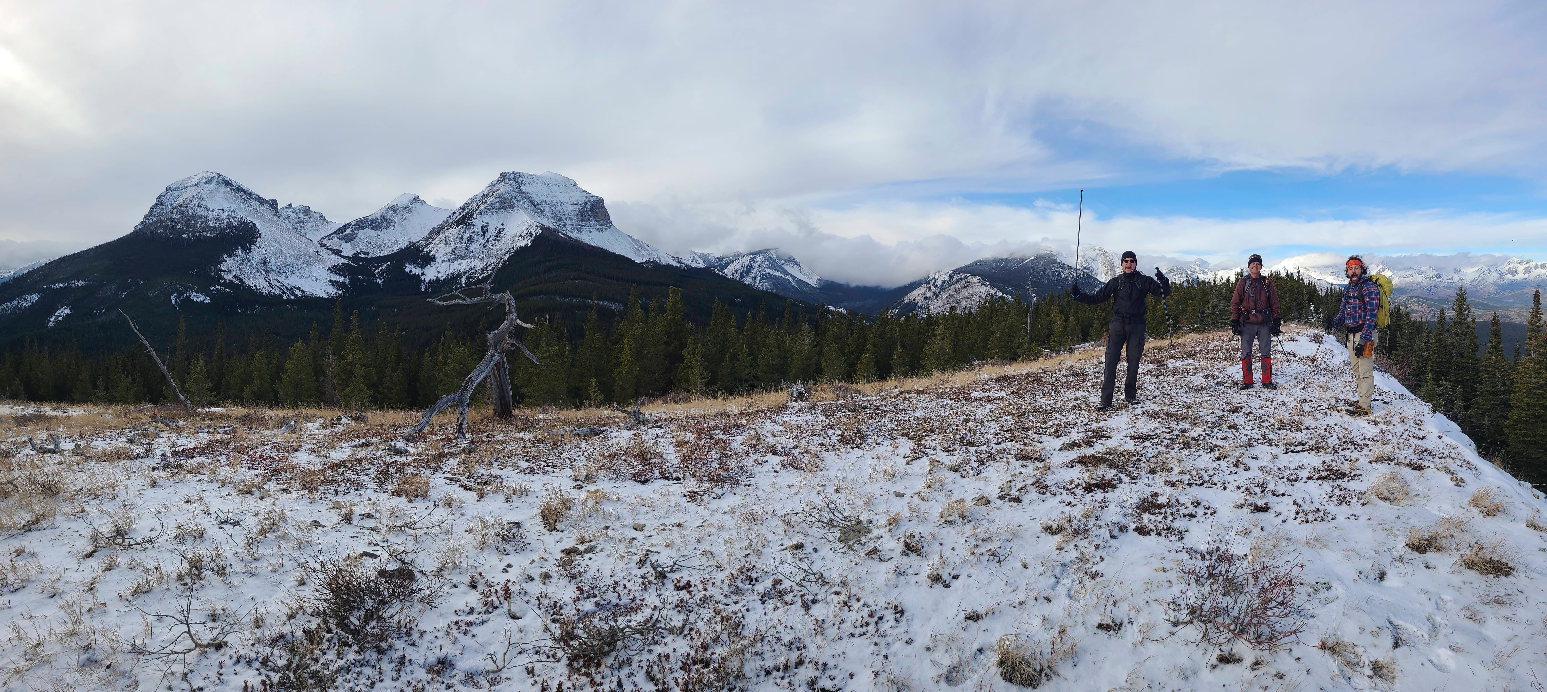
The summit of “Suicide Hill” (1989 m).

A pano to the northwest. The 360 views were definitely a treat!

A pano to the north…

And then one to south and southwest.

Finally a pano to the southwest and west as Lance, Andrew, and Brad celebrate our great achievement. 😂

“Suicide Hill” provides a fantastic view of all three peaks of Syncline Mountain.

Immediately to the west sits Mount McCarty.

Gazing towards the south end of the Flatheads where clouds obfuscate the summit of Centre E3 while leaving uniquely-shaped, Centre N1 (right), out in the open.

A few moments later however, the summit of Centre E3 finally comes into view.

Glorious Mount Darrah.

A closer look at Ptolemy SE5 (definitely high on my ‘To Do’ list 😁) with Mount McGladrey on the far left.

The north end of the Flatheads is capped by Mount Coulthard (centre) with diminutive, Mount McLaren to its right.

Clouds envelop the summits of both “Deadman Peak” (left) and Omahkai’stoo (Crowsnest Mountain).

A long glance towards Ma Butte (left) and McGillivray Ridge.

Finally, another look at the south end of the Livingstone Range.

As there was no cairn, I decided to make one. However, there weren’t many rocks to use, so I improvised with an old log. Brad mercilessly mocked me for wanting to build a cairn, so I naturally took the opportunity to bludgeon him in submission. Perhaps we should have nicknamed the mountain, “Murder Hill”? 😂 (Photo by Andrew Nugara)

After beating Brad until he was unconscious (I’m kidding! I’m kidding! It was actually the absinthe that knocked him out 😂), I get to work building a cairn. (Photo by Andrew Nugara)

I named the new cairn, ‘Geddy’, in honour of Lance’s affinity for Rush. 😂

I proudly stand beside Geddy, though unfortunately he is not on the ‘Lee’ side of the mountain. 😂 (Photo by Andrew Nugara)

Time to leave…

However, there were still plenty of views to enjoy as we made our way back to the trees.

Arriving back at the viewpoint where we had stopped for lunch.

At Brad’s suggestion, we chose to descend the open slopes beneath the viewpoint. This was a wise decision!

It ended up being a very quick descent!

We continued to be treated to great views of Syncline Mountain.

Nearing the end of the open slopes. GLR is the small treed bump in the centre.

A few minutes of light bushwhacking…

Brought us directly onto the secondary trail, only ~140 m from its junction with the GDT.

Back on the GDT.

Retracing our route along the trail.

Another GDT sign on the other side of the secondary trail. We wondered if these were placed to prevent hikers from mistaking the secondary trail for the GDT… Naw, it’s more logical to assume that the same witches who left the contraption on GLR, also left these. After all, the more complex a theory is, the closer to the truth it must be. 😂

Easy travel back to the creek.

Andrew leads the way across Suicide Creek.

Brad and Lance discuss the finer points of life.

Arriving back at the first fork.

The clouds had finally moved on from Castle Peak and Windsor Mountain.

The trail was not only signed, but the flagging tape was labelled as well. Those witches, they think of everything! 😂

Passing the point where we joined the trail from GLR.

An easy descent route is something I will never complain about. 😁

We head down…

And down…

Until we arrive next to Suicide Creek.

Another GDT sign marks the way. I would love to have a replica made of these!

Arriving in a clearing underneath the summit of GLR.

A closer look at the impressive cliffs of GLR.

We left the GDT to follow a small path towards our starting point on GLR.

However, the path soon disappeared and we were left with some light bushwhacking to reach the highway.

This was the worst it got for bushwhacking.

Arriving back at the highway.

From here, it was a quick ~500 m walk back to our vehicles.

Arriving back after a 9.2 km roundtrip distance over 4 hours and 10 minutes. This was an awesome day in the mountains and a HUGE thank you to Brad for suggesting that we start with GLR. I would’ve completely overlooked this fun little ridge walk! 😁 Again, and as always, it was fantastic to have such great company – with most of our time spent in laughter, good conversation, and the occasional bludgeoning. 😂

With time on our hands, Brad teaches us how to play ice axe golf – a fun activity that he plays when hiking with his dad.

Andrew tees up for his opening drive.

Lance makes an approach shot from the fairway…

And then finishes with a well-placed putt.

While Brad scouts the location for our third hole, Lance, Andrew and I check out GLR. Our route onto the crest went up through the trees on the right side of the initial section of cliffs (foreground). However, a much easier route can be found further to the left, where the slope is more gradual. If I were going to snowshoe GLR, this is where I’d begin – if I could find a safe place to park. We turned back a year ago because deep snow alongside the highway made parking impossible, so keep this in mind.


Leave a Reply