
⚠️ Hiking and scrambling are inherently dangerous activities. Please read my Disclaimer. ⚠️
One of my goals this year, was to tag the remaining summits along Anderson ridge in Paahtómahksikimi (Waterton National Park). Back in 2020, Brad, Dave, Keanan, Mark, and I were chased off the summit of Anderson Peak (2698 m) under blizzard-like conditions that nixed any thought of continuing on towards Lost Mountain (2509 m), which under normal circumstances, would be a quick trip. In fact, once you are on Lost, it makes sense to keep going and knock off “Kootenai Brown Peak” (2470 m) and Mount Bauerman (2403 m) before descending back to the Blakiston Creek trail and making the long hike back to your car.
However, our experience on Anderson meant that completing the remaining peaks would become piecemeal, which is fine for locals like Brad and I, who make multiple trips to the Park every year. It would suck though, if you lived further away and had to make the long drive back. That the remaining peaks are much further away from the trailhead than Anderson, is super inconvenient if you are forced into multiple trips, but as Monty Python reminds us, “Always look on the bright side of life” because at least you get to enjoy more hiking, right? 😂
Last month, Andrew and I completed an enjoyable loop of “Kootenai Brown” and Lost using the bowl between the two peaks as our access point. However, that still left Mount Bauerman for me to do but it also presented another opportunity – Kishinena Peak (2440 m). Had I completed the entire ridge in one shot, I doubt I’d have had the energy to scramble the east face of Kishinena, but by combining it as a trip with Bauerman, it made perfect sense. Now the only question was logistics, specifically, the best route to use on approach.
Fortunately, because Andrew is the Yoda of the mountains, he told me the answer while I was carrying him on my back on top of “Kootenai Brown”. Knowing my confusion as I gazed over to Bauerman, he leaned in and whispered, ‘Mmmm, Snowshoe Trail go you. Bike must you.’ – and that was that. I instantly knew our route for today. 😂
The only other decision to make was figuring out the order of ascent. Should we head up Sage Pass and follow the ridge to Kishinena; descend its east face and head up Bauerman as Andrew had done? Or should we head up Bauerman first and then scramble the east face of Kishinena before descending via Sage Pass? Thankfully, Brad was on the ball and made the wise suggestion to choose the latter.
The end result was a fantastic day full of great scenery topped off by an insanely fast return trip along the Snowshoe Trail. After talking with Brad, I think we will use this route to reach Festubert Mountain via South Kootenay Pass as it will be much quicker than hiking the Blakiston Trail.
Finally, according to Alberta Place Names by Larry Donovan and Tom Monto, Mount Bauerman is named after Hilary Bauerman who was the geologist on the British Boundary Commission from 1858 to 1862. The Commission was responsible for surveying the international boundary between the U.S. and British North America and is the source of several mountain names in the Park. A huge thanks to Brad for finding this information and passing it on.

To get to Mount Bauerman and Kishinena Peak, we drove to the Red Rock Canyon parking lot where the Snowshoe Trail begins. As one of the few trails in Paahtómahksikimi (Waterton) that allows bikes, we were able to make quick time (1 hour) to cover the ~8.5 km distance from the trailhead to the start of the Twin Lakes trail. Here is where we left our bikes.
We followed the Twin Lakes trail for ~3.7 km (1 hour) until we reach the first lake. We then passed through the campground and followed the Lone Lake trail above the second lake and onto the col between Bauerman and Kishinena. From the parking lot to the col it took us exactly 2 hours and 30 minutes.
The trip up Bauerman from the col is easy and direct. We simply followed the gradual ridge for ~2 km (324 m elevation gain) until we were on the summit. If you take away the distance from the parking lot, Bauerman from the col has to be one of the easiest peaks to reach in the Park.
After returning to the col and eating a quick lunch, we then set off up the east face of Kishinena Peak which is described by Andrew in More Scrambles in the Canadian Rockies, 3rd edition, as a moderate scramble. Though much steeper than Bauerman and seemingly much taller, Kishinena is all bark and no bite for in reality, it’s only 37 m taller than Bauerman and though the east face looks daunting, it lies-back nicely. Brad and I only had to put hand-to-rock a couple of times as it was more or less a steep hike over scree-covered ledges. From the col to the summit it was a 361 m elevation gain that took us almost hour on the nose.
From the summit of Kishinena, we then made the easy hike over to Sage Pass where we used the trail to descend ~1.4 km back to the main Twin Lakes trail. From here we followed the same route back to our bikes on the Snowshoe Trail. Once on our bikes it only took us 30 minutes to cover the ~8.5 km distance back to the trailhead and parking lot.

Our total distance travelled was 34 km with total elevations gains of 1409 m. Our total roundtrip time was 7 hours and 46 minutes.

Leaving the Red Rock parking lot. The Snowshoe trail starts on the other side of the bridge.

After several cool and rainy days, we lucked into a gorgeous morning.

The Snowshoe trail features a gradual grade that pays off on approach and more importantly, at the end of the day.

Thimbleberries encroach onto the trail.

Getting our first look at Mount Bauerman.

Easy riding on the upper section of trail.

Arriving at the Snowshoe hut and the end of the trail. From the parking lot it took us exactly 1 hour to cover the ~8.5 km to this point. On the way back, we’d make it from here to the parking lot in just 30 minutes. Zoom Zoom!

This is where we’ll leave our bikes.

The Snowshoe hut.

A map showing all the options in the area.

Setting off on foot after stashing our bikes.

Our view as we cross the creek. This is definitely a scenic corner of the Park.

The sign at the Twin Lakes trailhead. We still have 3.7 km to go to reach the lakes.

The trail was in great shape.

Emerging from the trees and into a scenic meadow. Mount Bauerman is on the left.

Finally getting our first good look at Kishinena Peak (centre).

A closer look at Kishinena and our ascent route up the east face. Though it looks daunting, it eases-back like David Lee Roth’s seat in Panama. 😂

A wider angle of the previous photo.

Continuing to enjoy our trip through the meadow. The trail will become steeper once we reach the trees in the centre.

The junction with the trail to Sage Pass. We will use this trail for descent at the end of the day.

Arriving at the first lake. It took us 1 hour to reach this point from the Twin Lakes trailhead and 2 hours in total since we leaving the parking lot.

Crossing the outlet stream.

Kishinena Peak is on the far left and later in the day, we will traverse the ridge in the centre.

The map at the entrance to the campground.

We were surprised that no one was here, but given the weather over the past few days, it would’ve been miserable camping.

The only occupant of the campground. (Photo by Brad Wolcott)

Another look at the first lake with Sage Pass to the right of centre.

Approaching the base of Kishinena.

We will follow the Lone Lake trail to reach the col between Bauerman and Kishinena.

Getting our first look at the second lake.

A lone deer grazes beside the lake.

Following the trail towards the col (left). (Photo by Brad Wolcott)

A pano from the trail.

Another look at the second lake.

My view back to Brad.

Arriving at the col. It took 30 minutes to reach it from the first lake and 2 hours and 30 minutes from the parking lot. From here it will be another ~2 km to reach the summit of Bauerman.

Brad leads the way as we begin to ascend Bauerman. The steepest part takes place within the trees – and it’s not that steep at all. Once you’re on the ridge, it’s an incredibly easy hike to the summit.

Arriving in a section burned by the 2017 Kenow wildfire. We couldn’t believe how the fire avoided the entire Twin Lakes valley.

Gazing down to the lakes shortly after leaving the col.

Looking back at Kishinena.

Clear air meant we could see a number of peaks. This is looking north at Font Mountain (centre), Mount Matkin (right of centre), and Jutland Mountain (left). Both Font and Matkin are on this year’s ‘To Do’ list. 😊

Looking down at the Twin Lakes trail and the meadow we hiked through.

Once we were out of the trees, the grade eased and it became an enjoyable walk.

Closing in on the false summit.

Glancing back.

Nearing the top of the false summit.

From the top, we could see that the actual summit was not far away.

The other nice thing about today was the lack of wind. It was simply a beautiful day to be on a mountain. 😊

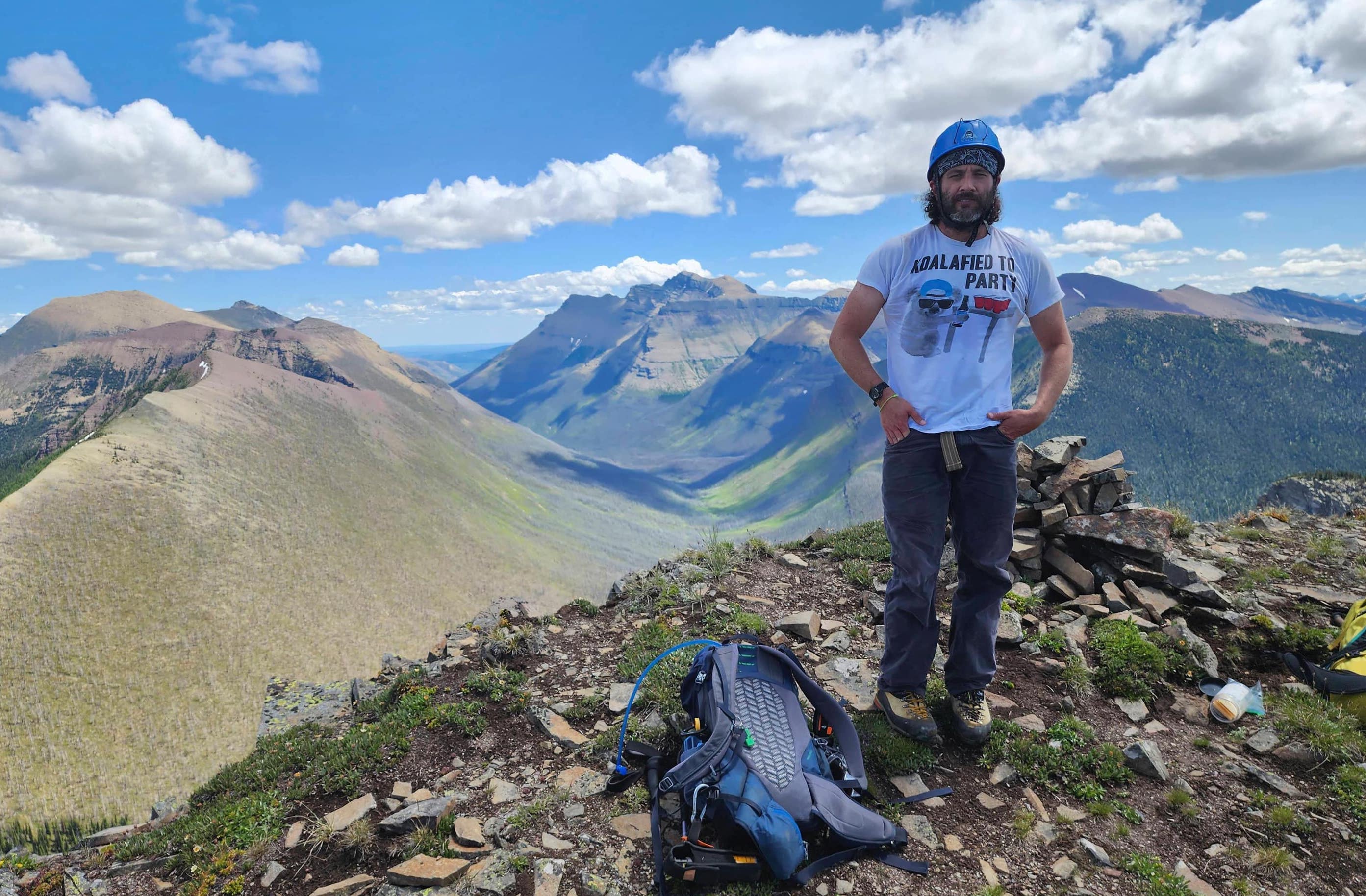
The summit of Mount Bauerman (2403 m).

Looking to the east…

And now to the southeast.

The view to the southwest…

And now to the west.

Gazing northwest…

And finally, to the north.

Looking along the ridge to “Kootenai Brown Peak” (foreground), Lost Mountain (right), and Anderson Peak (left). It took a while, but it’s satisfying to have finally tagged every peak on this ridge. 😀

A closer look at three very fun peaks: “Cloudowan Peak” (left), “Cloudy Junior” (right of centre), and Cloudy Ridge (right).

Mount Glendowan was another excellent trip.

It still puzzles me why the very prominent, “Newman Senior”, is not officially named. 🤔

I only have a handful of official summits left to complete in Paahtómahksikimi, and Avion Ridge (foreground) is one of them. I think I will come back in the next month and tag it. 🤔 Edit: Done!

Looking past Avion Ridge to Spionkop Ridge and Loaf Mountain.

Zooming in on Victoria Ridge (left) and Victoria Peak (right).

The clear air left us with a great views of Castle Peak (left), Windsor Mountain (left of centre), “Mill Creek Mountain” (middle distance right), “Mill Creek Peak” (middle distance far right), and Mount Gladstone (right).

Looking across the valley towards “Sage Pass Peak” (foreground) and “Sage Senior”.

Zeroing in on Font Mountain (centre). Behind it are Jutland Mountain (left), La Coulotte Peak (left), and Lys Ridge (right).

A good look at Sage Pass (right of centre).

Our next destination for the day, Kishinena Peak. 😀

Kenow Mountain is in the centre with Miskwasini Peak to its left.

It’s hard not to miss Starvation Peak (right of centre) and King Edward Peak (left of centre).

Long Knife Peak has a fresh dusting of snow.

Two other peaks that I need to visit this year: Lone Mountain (foreground; Edit: done!) and Festubert Mountain (right). Edit: done!

Gazing over at Mount Hawkins.

Dr. Ninna Piiksii has uncovered that there were two Siksikaitsitapi names for Mount Blakiston. The first is Piinaquiium or “Seen From Afar Mountain” and the second is, Ahkoinimahstakoo or “Pipestone Mountain”. I’ve chosen to include both when referring to the mountain and to put the original names ahead of the colonial name.

Brad chillin’ on our first peak of the day…

And then there’s me. 😂😂 (Photo by Brad Wolcott)

After a short stay, it was time to head back to the col.

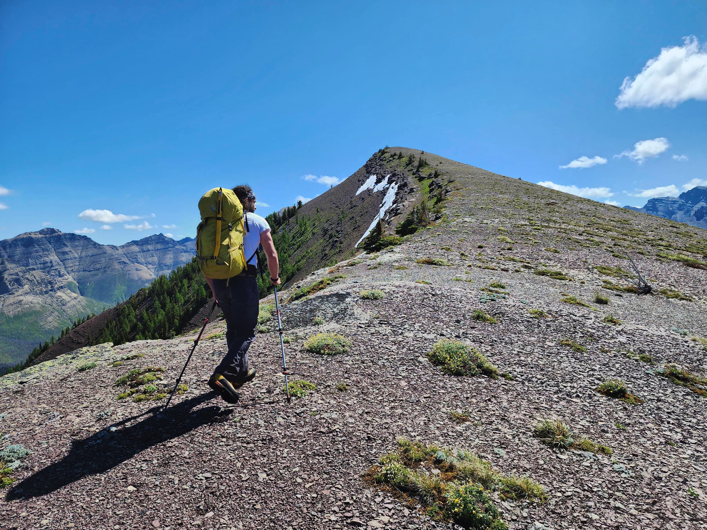
Eyeing up Kishinena’s east face.

It was a quick and easy trip back to the col.

Another lake photo with more to come.

The small bump in the centre is what some maps label as Kishinena Peak.

A closer look at the small tarn that sits below the disputed summit.

Almost back at the col…

And just like that, we’re there. By this point, it had only been 4 hours since we left the parking lot.


Leave a Reply