

⚠️ Hiking and scrambling are inherently dangerous activities. Please read my Disclaimer. ⚠️
Continuing my focus on Paahtómahksikimi (Waterton National Park), Brad and I took advantage of an excellent forecast to make the long, but enjoyable trip up Lone Mountain . Though it’s an easy mountain to ascend, its location along the western edge of the Park makes reaching it the most difficult part of the journey. Fortunately, there are several excellent trails and the only off-trail stuff comes while ascending the easy south slope of the mountain.
As it’s located directly to the north of Festubert Mountain, Brad and I had originally planned to ascend Lone and then follow the trail onto the shoulder beneath Festubert’s east ridge. From here, we would try and find a scramble route along the ridge to the summit. However, after scoping potential routes from Lone, we concluded that though it may be possible (with a good measure of exposure), tacking such an exploration onto an already long day, was not wise. Hence, we’ll return for Festubert sometime in the not-too-distant future. Edit: Done! 🙂
Andrew Nugara describes the route for Lone Mountain in, More Scrambles in the Canadian Rockies, with access via the Blakiston trail. Given our recent ascents of Kishinena Peak and Mount Bauerman from Twin Lakes via the Snowshoe trail, we concluded that using this approach would be the best choice for several reasons. First, though it’s longer in distance, the fact that we could cover ~8.5 km of it on bikes evened things out. Second, the elevation loss / gain from the Bauerman / Kishinena col to Lone Lake was minimal. Third, neither Brad or I had followed the trail off the col and through Blue Grouse Basin before, which gave the route a higher factor of intrigue. Fourth, the route would allow us to pass beside four different lakes; and finally, the approach via Twin Lakes is largely sheltered from the morning sun which for a long approach on a hot day, makes all the difference in the world. 😊
It was only when we returned, that we discovered that Vern deWit had also used this same approach for Lone Mountain and Kishinena Peak in 2021. Again, this route only makes sense if you use bikes on the Snowshoe trail; otherwise, Blakiston trail is the best route – unless of course you are tackling Lone as part of a backpacking trip, which is what many people do.
As for the experience, both Brad and I agreed that this was a day well-spent. The views from the summit of Lone Mountain were surprisingly good as was the scenery we encountered along the trail. In fact, Blue Grouse Basin is a neat little corner of the Park that is well-worth visiting. Moreover, the almost 43 km roundtrip distance was not tiring and went by quickly – again, with our bikes being the secret weapon.
Though we never made it to Festubert, we’ll be back, only this time using South Kootenay Pass to access the ridge. A huge thanks to Brad for another awesome day in the mountains and for suppling the sambuca. 🤪

To get to Lone Mountain, we drove to the Red Rock Canyon parking lot where we accessed the Snowshoe trail. From the trailhead we biked for ~8.5 km (56 minutes) until we reached the end of Snowshoe and the sign for the Twin Lakes trailhead. From here, we hiked for ~3.7 km until we reached the first of the Twin Lakes (45 minutes). We continued along the trail for another ~1 km until we reached the Bauerman / Kishinena col 2 hours after leaving the Red Rock parking lot.
From the col we then made the gradual descent into Blue Grouse Basin, reaching the small tarn after an easy ~1.2 km hike. We then followed the trail for another ~1 km until we arrived at the junction with the Blackiston trail and the trail to South Kootenay Pass. Continuing straight, we hiked for another ~4.2 km until we arrived at the hut and horse corral at Lone Lake. In total, it took us 3.5 hours to cover the ~18.7 km from the Red Rock parking lot to this point.
To avoid losing elevation down to the lake, we started up the slope of Lone Mountain just behind the corral, trending slightly to climber’s right until we were on the open the ridge. It was an easy ~2 km (357 m elevation gain) hike to the summit and we were pleased to see that it only took 1 hour; meaning that it took us just 4.5 hours to cover the 20.7 km total distance to the top.
After enjoying the views and studying the east face and ridge of Festubert, we descended the way we came, finding ourselves back at the stables in only 30 minutes. We then proceeded a couple hundred metres down the trail where we lounged around Lone Lake for an hour, eating lunch, drinking booze, and deciding whether to continue on to Festubert.
Choosing to come back another day, we returned the way we came and were surprised (and thankful) how gradual the elevation gain was back to the col. Once on the col, the entire trip back was downhill; taking 1 hour from the col to reach our bikes and then another 30 minutes to cover the ~8.5 km back to the parking lot.

Our total distance travelled was 42.7 km with a total roundtrip time of 9 hours and 34 minutes (including a leisurely 1 hour lunch break at Lone Lake). Total elevation gains were 1438 m.

Starting off at first light from the Snowshoe trailhead at Red Rock Canyon.

Passing beside “Newman Senior” (far right) and Avion Ridge (far left)

The first rays of light on Avion Ridge. One of the benefits to this approach on a hot day, is the shade it offers from the morning sun. The same can’t be said for the alternate approach along the Blakiston trail.

Gazing over at “Kootenai Brown Peak” (left) and Mount Bauerman (right).

Arriving at the end of the Snowshoe trail. It only took us 56 minutes to cover the ~8.5 km from the trailhead, but keep in mind, we’re using old school human-powered bikes, so this time would be significantly less with e-bikes. On the way back, it will only take us 30 minutes to reach the parking lot.

After stashing our bikes in the trees, we set off on foot for the Twin Lakes.

The sign at the trailhead.

Easy hiking along a good trail. This would remain true for the entire day.

Arriving in the first meadow and looking up at Mount Bauerman. (Photo by Brad Wolcott)

Kishinena Peak glows under the morning sun.

The hike to Twin Lakes is always scenic. 🙂

Passing the junction with the Sage Pass trail.

The first of the two Twin Lakes. It only took us 45 minutes to reach this from where we left our bikes.

Following the trail towards the Kishinena / Bauerman col (far left) with Kishinena Peak in the centre.

The second lake.

Some goats enjoying the sun.

Looking back towards Sage Pass (right). (Photo by Brad Wolcott)

Another look at the second lake.

More of the same.

On the Kishinena / Bauerman col. It took us 2 hours to reach this point from the Red Rock parking lot.

Gazing through the trees at Festubert Mountain. Our original plan was to try and find a scramble route along the skyline east ridge.

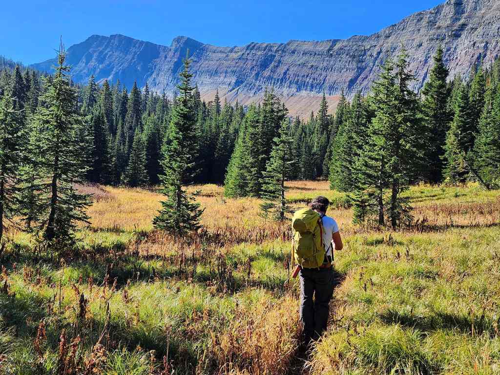
Making the gradual descent into Blue Grouse Basin. Visiting this area was a highlight of the trip! 😊

Lone Mountain (left) with its south ridge skyline (centre).

Glancing back to the col. (Photo by Brad Wolcott)

Hiking through one of many picturesque meadows.

Blue Grouse Basin gets two thumbs up! 👍 👍

Approaching a small tarn.

We’d wanted to visit this tarn since seeing it from Mount Bauerman and Kishinena Peak.

A closer look at the tarn. Since it’s in Blue Grouse Basin, does this mean that it’s the Blue Lagoon? After not seeing Brooke Shields anywhere, we continued hiking… 😂

Looking back at the col and the gradual elevation loss.

Hiking through a section that was burned in the 2017 Kenow wildfire.

Arriving at the junction with the Blakiston trail.

Only 4.2 km to reach Lone Lake.

When we come back for Festubert, we plan to use South Kootenay Pass.

Looking ahead to Lone Mountain (left) and Festubert Mountain (centre).

We kept expecting a substantial change in elevation, but it never came.

Gazing back at Mount Bauerman (left of centre), “Kootenai Brown Peak” (right), and Lost Mountain (far right).

Back inside the forest…

And then emerging onto another stunning meadow.
More of the same.

The wall on this section of trail was particularly impressive.

While the goats were hanging out by Twin Lakes, the sheep were near Lone Lake. This seems biblical somehow… 😂

Arriving at the cabin and corral at Lone Lake. It took us only 3.5 hours to cover the ~18.7 km to this point.

The sign alongside the trail.

We’ll check out the cabin on the way back.

To avoid losing elevation, we’ll begin our ascent of Lone behind the corral.

Brad leads the way as we leave the trail.

Lone is much like Mount Bauerman: a short section of steep terrain near the bottom and then a long but gradual ridge to the top. Both are very easy mountains to hike.

It wasn’t long before we got our first view of Lone Lake nestled beneath Festubert Mountain. Even from here, I could see fish rising in the lake.

After the initial steep section, we trended climber’s right to gain the open ridge.

Gazing back.

Zooming in on Lone Lake.

From this point on, it was mostly open ridge to the summit.

The view over to Mount Hawkins (right of centre).

It was a gorgeous September day!

Taking in the view. We were surprised at what Lone offered. 😊

Another look back.

We kept a constant eye on the east ridge of Festubert (upper left) in the hope of finding an obvious route.

A cool twisted tree.

Brad continues to lead the way.

His view back to me. (Photo by Brad Wolcott)

Only a few larches had changed colour. It won’t be long however, until the mountains are shrouded in golden yellow.

Passing beside an interesting pit.

Closing in on the top.

A large cairn marks the summit of Lone Mountain (2420 m)

A pano to the south…

And then to the west.

Looking north…
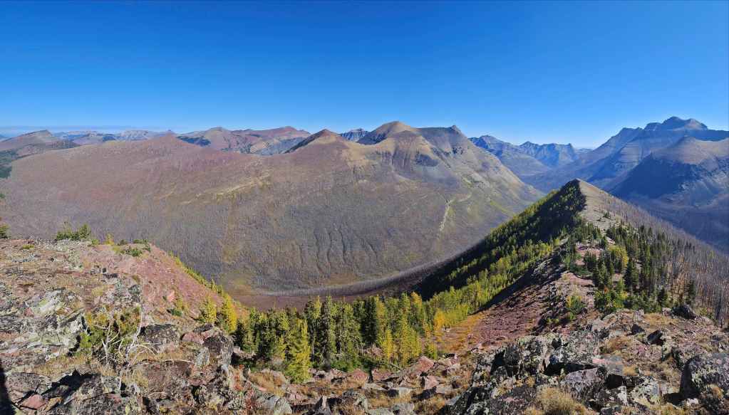
And then northwest.

Finally, a pano to the east.

Gazing across the valley to Mount Hawkins (centre).

Mighty Piinaquiium / Ahkoinimahstakoo (Mount Blakiston).

Looking east along the Bakiston Valley at “Rogan Peak” (left) and Mount Galwey (right).

Zeroing in on Mount Dungarvan.

Anderson Peak with Lost Mountain in front of it.

Zooming past Anderson to Mount Glendowan.

“Kootenai Brown Peak” (centre) sits across the valley.

Colourful “Newman Senior”.

Distinctive – and diminutive – Newman Peak (centre).

Glancing over to Spionkop Ridge (centre) with Avion Ridge in front of it.

Mount Bauerman and Lone Mountain have similar ascents.

Zooming past the summit of Bauerman to Victoria Peak (centre).


A telephoto of Castle Peak (left) and Windsor Mountain (right).

Another one on my list: “Sage Senior” (centre).

Gazing over at Kishinena Peak. The tarn we passed in Blue Grouse Basin is beneath it (bottom right of centre).

Looking west at Kenow Mountain (left) and Langemarck Mountain (right).

Miskwasini Peak (left) and Kenow Mountain (right of centre).

King Edward Peak (left) and Starvation Peak (right).

Long Knife Peak (left) and See Peak (right).

A closer look at See Peak which sits on Kishinena Ridge. Yet another peak on my list. 🙂

Another look at Festubert Mountain.

Akamina Ridge (left of centre) with Mount Carter (left) and Rainbow Peak (right) behind it.

Another look to the west. (Photo by Brad Wolcott)

There’s no shortage of colour on Lone Mountain. (Photo by Brad Wolcott)

Me on the summit. (Photo by Brad Wolcott)

Brad rockin’ the same shirt from our Kishinena Peak trip.

Heading down to Lone Lake…

And making great time.

At this point, we were still hoping to try our luck at scrambling Festubert’s east ridge (left).

Back on the steep section…

And then emerging from the trees behind the corral.

Heading over to the lake.

Passing beside a campfire / dining room.
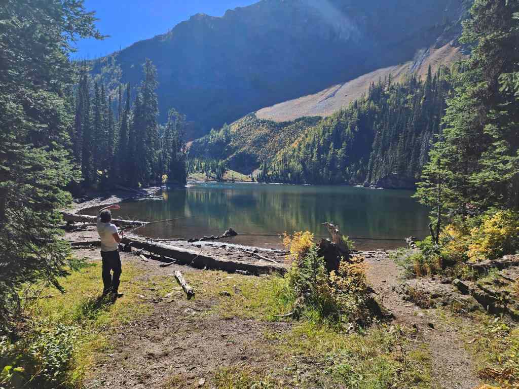
This was my first and Brad’s second visit to Lone Lake.

We discussed continuing on to try and find a route up Festubert, but after looking at the upper section of the ridge from the slopes of Lone Mountain, we concluded that while there may be a route, it might take us longer to find it than there was time left in the day. We decided to enjoy our time at Lone Lake and spent a good hour enjoying the scenery and relaxing.

After seeing lots of rising fish from Lone Mountain, it was no surprise to see lots of cuts cruising around.

I love watching fish. 🙂

Watching fish and drinking sambuca.

After an hour at the lake, it was time to head back, but not before checking out the cabin.

Everything was locked up…

But the view from the front porch was pretty awesome!

Back on the trail.

Crossing one meadow…

And then another.

Looking back at Festubert (left).

Back onto the burned section.

Gazing along the valley towards Piinaquiium / Ahkoinimahstakoo (Mount Blakiston)

Arriving at the junction with Blakiston trail…

And then arriving in Blue Grouse Basin.

A pano of the tarn in Blue Grouse Basin.

More of the same.

Kishinena Peak towers above the Basin.

Gaining easy elevation back to the col.

Almost there.

One last look at Lone Mountain (right).

Back on the col…

And now descending back to Twin Lakes.

The second lake.

A group of trail riders beside the lake.

Gazing down the valley at Mount Glendowan (left), “Cloudowan Peak” (centre), Cloudy Ridge (right of centre), and Anderson Peak (right)

Passing beside the first lake…

And then enjoying more awesome meadows.

Getting closer…

And finally arriving back at our bikes.

We will cover the final ~8.5 km in just 30 minutes.

Arriving back at the Red Rock Parking lot nearly 43 km and 9.5 hours after starting. Though it was a long trip, it felt much quicker because of great trails, great scenery, and great company. Though we bailed on trying to find a route up Festubert’s east ridge, we’ll definitely be back for it – but with an approach using South Kootenay Pass. Edit: Done! 🙂


Leave a Reply